簽到天數: 4044 天 [LV.Master]伴壇終老
|
本資料
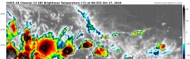
編號 :91 E
擾動編號日期:2024 年 10 月 27 日 14 時
撤編日期 :2024 年 10 月 00 日 00 時
EP, 91, 2024102706, , BEST, 0, 102N, 1172W, 30, 1008, DB, 34, NEQ


Tropical Weather Outlook Text EspañolTropical Weather Discussion
ZCZC MIATWOEP ALL
TTAA00 KNHC DDHHMM
Tropical Weather Outlook
NWS National Hurricane Center Miami FL
1100 PM PDT Sat Oct 26 2024
For the eastern North Pacific...east of 140 degrees west longitude:
Active Systems:
The National Hurricane Center is issuing advisories on Tropical
Storm Kristy, located over the western portion of the eastern
Pacific basin.
1. Western East Pacific:
An area of low pressure is forming within a large area of
disorganized showers and thunderstorms located well to the southwest
of the southwestern tip of the Baja California peninsula.
Environmental conditions appear conducive for additional development
of this system, and a tropical depression is likely to form by the
early to middle part of the upcoming week while moving westward or
west-northwestward at about 15 mph over the far western portion of
the eastern Pacific basin. This system is expected to move into the
central Pacific basin on Wednesday or Thursday.
* Formation chance through 48 hours...low...30 percent.
* Formation chance through 7 days...high...80 percent.
Forecaster Papin
|
|

 提升卡
提升卡 千斤頂
千斤頂