開啟輔助訪問
 找回密碼
 立即加入

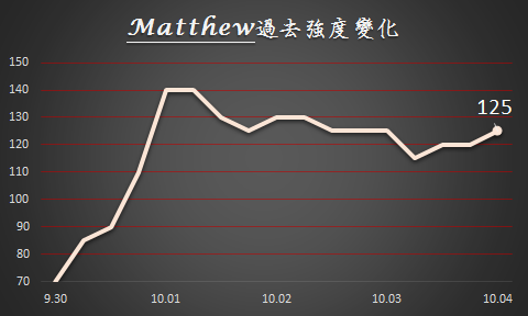
14L.Matthew 北大9年來首個五級颶風 吹襲加勒比海周邊國家

簽到天數: 3279 天

[LV.Master]伴壇終老

t02436|2016-10-4 13:44 | 顯示全部樓層
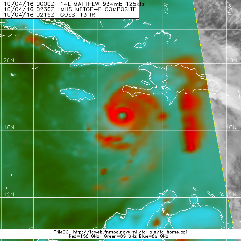
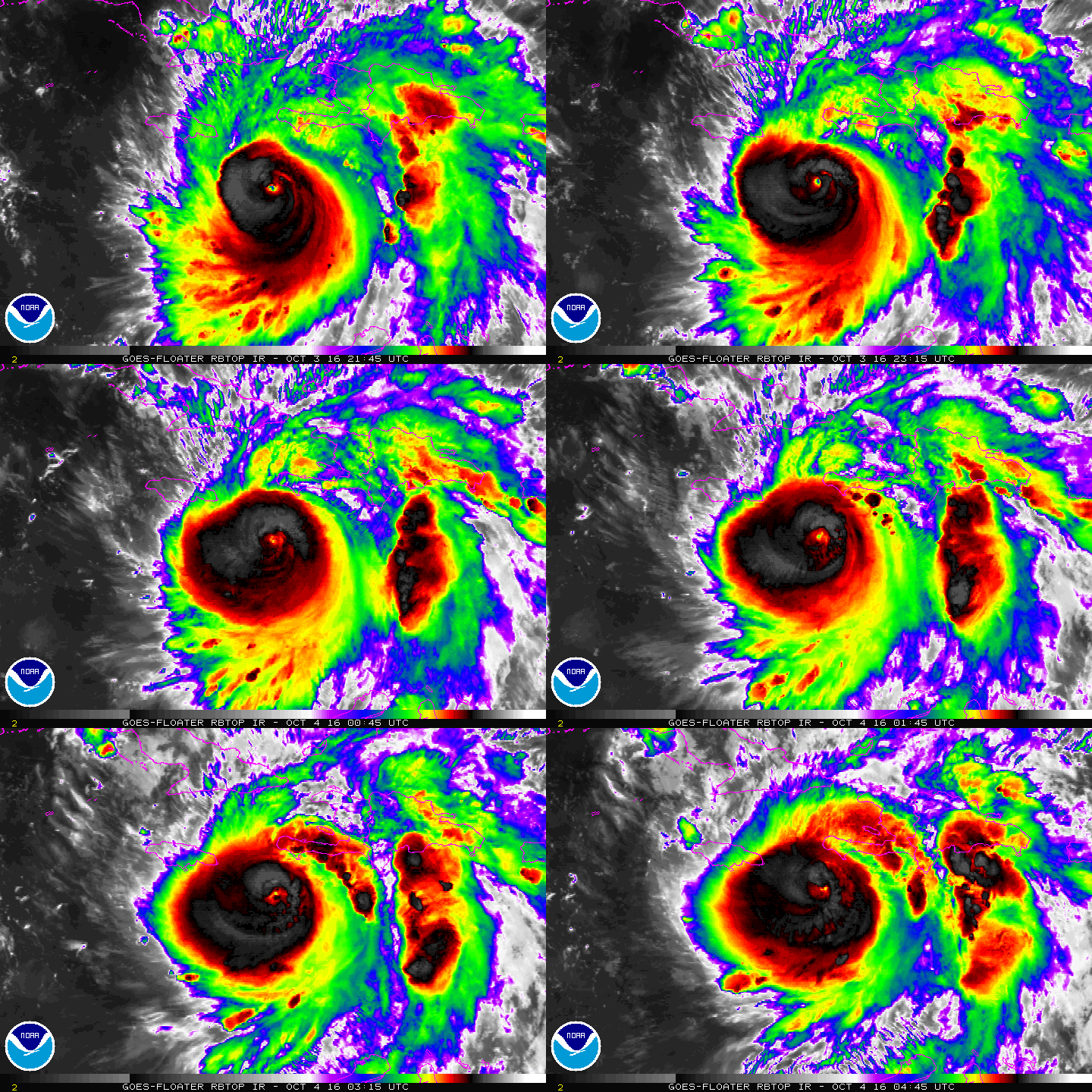
NHC根據實測再調升強度至125節,12小時之後將擦過海地西岸,一天後登陸古巴。
000
WTNT44 KNHC 040257
TCDAT4

HURRICANE MATTHEW DISCUSSION NUMBER  24
NWS NATIONAL HURRICANE CENTER MIAMI FL       AL142016
1100 PM EDT MON OCT 03 2016

An Air Force Reserve Hurricane Hunter aircraft this evening measured
two peak SFMR winds of 125 kt in the northeastern eyewall, along
with a peak flight-level wind of 129 kt. The lowest pressure
measured by a dropsonde has been 934 mb, down 6 mb since the
previous flight. Based on these data, the initial intensity has been
increased to 125 kt.

Matthew continues to move a little east of due north, or 010/07 kt.
There is no change to the previous short-term track forecast
reasoning. Matthew is expected to move northward around the western
periphery of a strong deep-layer ridge for the next 24 hours,
followed by a north-northwestward motion at 36 and 48 hours. That
portion of the new forecast track is essentially the same as the
previous advisory, bringing Matthew over the southwestern peninsula
of Haiti tonight and near or over eastern Cuba on Tuesday. Beyond 48
hours, the GFS has again trended westward, and now lies closer to
the UKMET model track. This change might be related to the
mid-/upper-level trough currently located over the eastern Gulf of
Mexico, which is now forecast to split, with the northern portion
lifting out to the northeast and dissipating while the southern
portion cuts of into a low pressure system that drops southward over
the northwestern Caribbean Sea by 36-48 hours.   The new track
forecast has again been shifted westward closer to Florida, and lies
near a blend of the 18Z GFS and 12Z ECMWF model solutions.

Only slight weakening is expected during the next couple of days due
to Matthew interacting with the land masses of western Haiti and
eastern Cuba. After the hurricane emerges over the Atlantic waters
between Cuba and the Bahamas, low vertical wind shear and warm SSTs
of near 30C should help Matthew to recover some before southwesterly
wind shear increases by 96-120 hours and induces a faster rate of
weakening. The new NHC intensity forecast is basically identical to
the previous advisory, and closely follows the consensus model IVCN.

KEY MESSAGES:

1.  Matthew is likely to produce devastating impacts from storm
surge, extreme winds, heavy rains, flash floods, and/or mudslides in
portions of the watch and warning areas in Haiti, Cuba, and the
Bahamas.  Please consult statements from the meteorological services
and other government officials in those countries.

2.  Direct hurricane impacts are possible in Florida later this
week.  Tropical storm and/or hurricane watches are likely tomorrow
morning for portions of the Florida peninsula and the Florida Keys.

3.  Tropical storm or hurricane conditions could affect portions of
Georgia, South Carolina, and North Carolina later this week or this
weekend, even if the center of Matthew remains offshore.  It is too
soon to specify what, if any, direct impacts Matthew might have on
the remainder of the U.S. east coast farther north.  At a minimum,
very dangerous beach and boating conditions are likely along much of
the U.S. east coast later this week and weekend.

FORECAST POSITIONS AND MAX WINDS

INIT  04/0300Z 16.9N  74.6W  125 KT 145 MPH
12H  04/1200Z 18.3N  74.5W  125 KT 145 MPH
24H  05/0000Z 20.0N  74.4W  120 KT 140 MPH
36H  05/1200Z 21.8N  75.2W  115 KT 130 MPH
48H  06/0000Z 23.4N  76.2W  110 KT 125 MPH
72H  07/0000Z 26.6N  78.7W  105 KT 120 MPH
96H  08/0000Z 30.0N  79.6W  100 KT 115 MPH
120H  09/0000Z 33.3N  77.6W   90 KT 105 MPH

$$
Forecaster Stewart
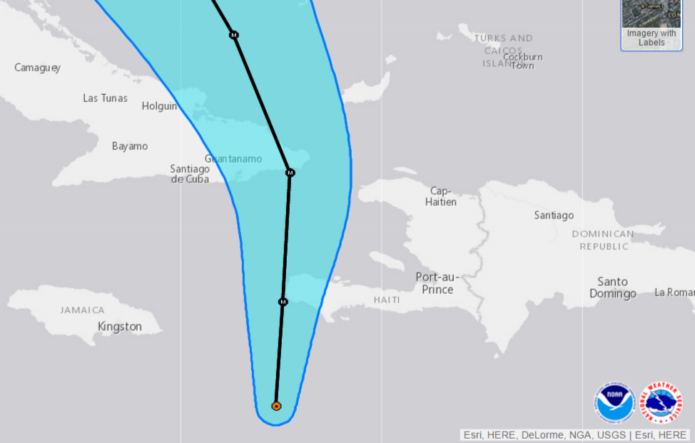
NHC TRACK 100403Z.png

14L.png

底層還是相當強悍...
20161004.0236.metopb.89rgb.14L.MATTHEW.125kts.934mb.16.6N.74.6W.090pc.jpg

實測目前持續進行中,最新SMFR測得126節風速,保重了...
044400 1716N 07418W 6984 02666 9474 +139 //// 176115 122 124 002 01
044430 1716N 07417W 6966 02720 9538 +133 //// 175128 132 126 006 01
044500 1716N 07416W 6980 02738 9567 +131 //// 172135 136 126 005 01
044530 1716N 07414W 6965 02780 9611 +128 +128 171129 135 120 013 03
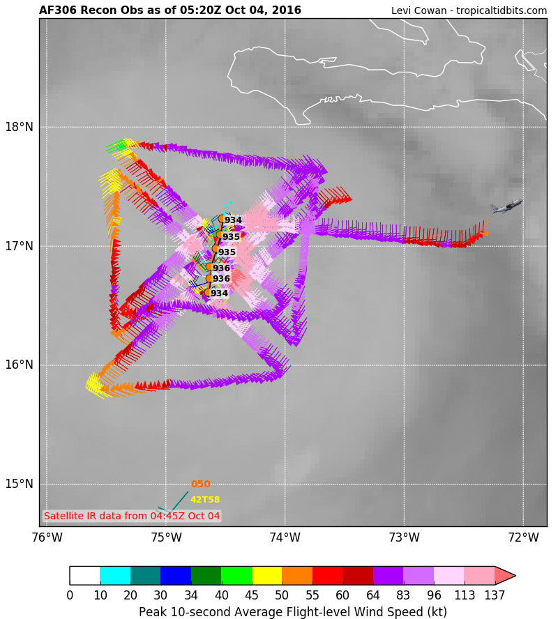
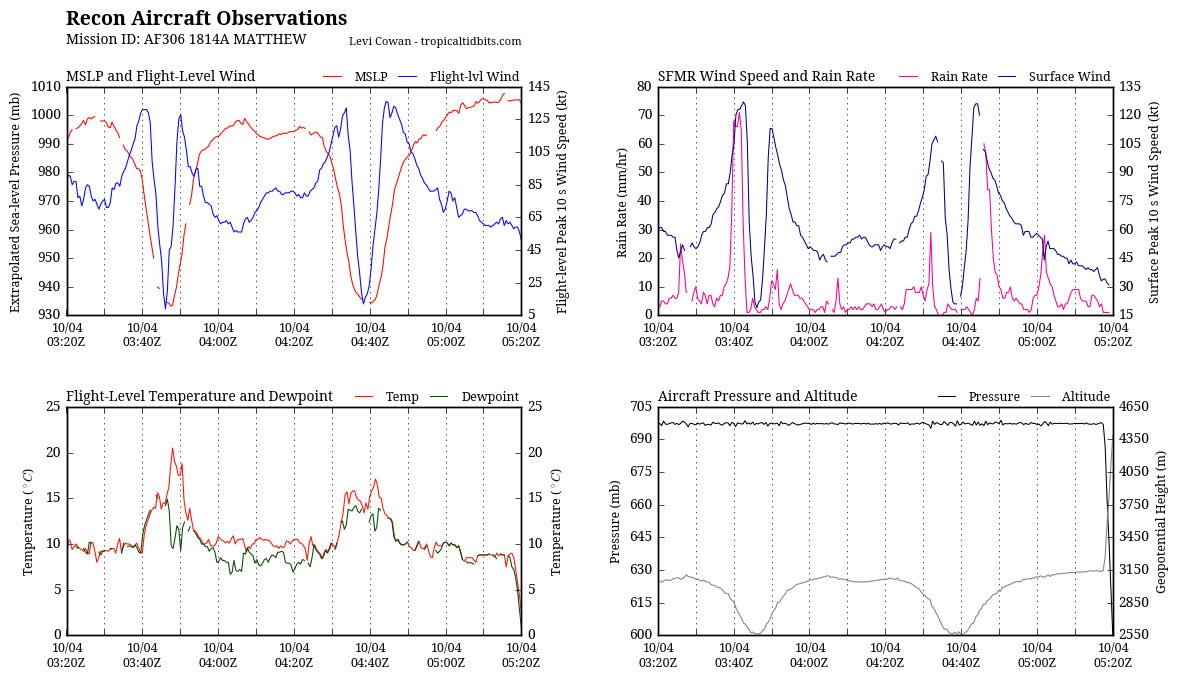
recon_AF306-1814A-MATTHEW.png

recon_AF306-1814A-MATTHEW_timeseries.png

rbtop-animated.gif

點評

的確  發表於 2016-10-4 19:52
結果現在的中心氣壓比140kts時還來的低,再次證明風速和氣壓並非絕對的關係  發表於 2016-10-4 15:27
回復

使用道具 舉報

簽到天數: 582 天

[LV.9]以壇為家II

蜜露|2016-10-2 19:43 | 顯示全部樓層
本帖最後由 蜜露 於 2016-10-2 19:44 編輯


(上圖) 馬修        940hPa  140kts
(下圖) 菲尼克斯 929hPa 145kts

近10年來菲尼克斯是大西洋最有霸氣感覺.
20160930.2315.goes13.x.ir1km_bw.14LMATTHEW.110kts-955mb-135N-713W.100pc.jpg


20070902.2315.goes12.x.ir1km_bw.06LFELIX.120kts-NAmb-134N-725W.100pc.jpg


點評

ktf
馬修北上後有可能成為今年為止風場最大的熱帶氣旋  發表於 2016-10-2 20:15
ktf
馬修表示:不急,北上後和高壓梯度加成後,會變成超大風場氣勢強大的環流  發表於 2016-10-2 20:14
Felix中文音譯不是費利克斯嗎?怎麼變菲尼克斯(Fenix)了?另外這颶風最佳路徑強度不是給予150kts了嗎?  發表於 2016-10-2 20:04
回復

使用道具 舉報

簽到天數: 3279 天

[LV.Master]伴壇終老

t02436|2016-10-2 11:13 | 顯示全部樓層
中心開始減速滯留,準備轉向。
rb-animated.gif

20161002.0006.f18.91pct91h91v.14L.MATTHEW.130kts.942mb.13.2N.73.3W.055pc.jpg

21Z升回130節,03Z維持評價,只不過路徑再向東調整,換海地遭殃了:L。
ZCZC MIATCDAT4 ALL
TTAA00 KNHC DDHHMM

HURRICANE MATTHEW DISCUSSION NUMBER  15
NWS NATIONAL HURRICANE CENTER MIAMI FL       AL142016
500 PM EDT SAT OCT 01 2016

Matthew's cloud pattern has improved this afternoon, with the small
eye becoming more distinct.  A NOAA hurricane hunter aircraft
recently found peak SFMR winds of around 130 kt, and a peak
7,000-ft flight-level wind of 135 kt.
The initial intensity is
raised to 130 kt for this advisory.  The wind field has contracted
today, and the radius of maximum winds is now about 6 n mi.  The
latest minimum pressure based on a dropsonde from the aircraft is
940 mb.  Radar imagery from the NOAA plane suggests that an outer
eyewall may be forming, but the current eye has been resilient
today.  Some gradual net weakening is expected during the next day
or so, but Matthew is expected to remain a powerful hurricane until
it begins to interact with the landmasses of Jamaica, eastern Cuba,
and Hispaniola in 48 to 72 hours.  Some weakening is expected during
that time, but conditions appear conducive for restrengthening once
Matthew moves into the Bahamas late in the forecast period.  The NHC
forecast is well above the intensity consensus through much of the
period.  Note that there will likely be short-term fluctuations in
intensity like we've seen today due to internal dynamics, including
eyewall replacement cycles, that are not shown here.

Matthew has made a small cyclonic loop since the last advisory, and
the initial motion estimate is a northwestward drift at around 3 kt.
The mid-level ridge centered near Bermuda is expected to weaken and
shift eastward, causing Matthew to turn northward while it moves
into a weakness in the ridge during the forecast period.  The track
model guidance has shifted a little to the east in the short range,
and the NHC track during this time has been adjusted in that
direction, in agreement with the latest multi-model consensus.

Late in the period the track model spread remains considerable, as
the global models continue to have issues depicting the synoptic-
scale pattern over the eastern United States and western Atlantic in
4-5 days.  The evolution of the mid/upper-level low currently
centered over the Ohio Valley and how it interacts with the western
Atlantic subtropical ridge appear to be critical to the long-term
track of Matthew.  The UKMET and ECMWF tracks have shifted westward
and slower by day 5, while the GFS has trended east.  This has
narrowed the guidance envelope somewhat, but given the lack of
run-to-run consistency I'd hesitate to say that confidence in the
long-range track forecast has increased by any appreciable measure.
The new NHC track at these times leans heavily on continuity, and by
day 5 is close to the GFS/ECMWF blend and left of the latest
multi-model consensus aid TVCN.

It is important to remind users that average NHC track forecast
errors are around 175 miles at day 4 and 230 miles at day 5.
Therefore, it is too soon to rule out possible hurricane impacts
from Matthew in Florida.

FORECAST POSITIONS AND MAX WINDS

INIT  01/2100Z 13.5N  73.4W  130 KT 150 MPH
12H  02/0600Z 13.6N  73.8W  125 KT 145 MPH
24H  02/1800Z 14.8N  74.4W  120 KT 140 MPH
36H  03/0600Z 16.1N  74.9W  115 KT 130 MPH
48H  03/1800Z 17.6N  75.0W  110 KT 125 MPH
72H  04/1800Z 21.0N  75.0W   95 KT 110 MPH
96H  05/1800Z 24.5N  75.5W  100 KT 115 MPH
120H  06/1800Z 26.5N  76.0W  100 KT 115 MPH

$$
Forecaster Brennan

NNNN

025316W_sm.gif

20161002.0215.goes-13.ircolor.14L.MATTHEW.130kts.940mb.13.5N.73.4W.100pc.jpg

點評

長腫瘤  發表於 2016-10-2 17:51
這旋臂真奇葩XD  發表於 2016-10-2 13:49
怎覺得外圍雲系的對流比中心附近還強啊?  發表於 2016-10-2 12:06
回復

使用道具 舉報

簽到天數: 3279 天

[LV.Master]伴壇終老

t02436|2016-10-1 23:28 | 顯示全部樓層
從動圖來看北側明顯破了,NHC搭配實測結果持續調降強度,09Z降135節,15Z再降至125節。
bd0.gif

rbtop-animated.gif

眼牆置換或許已經開始,但官方還在等待最新的掃描。
另外,NHC跟隨GFS06Z,15Z東調認為Matthew將不會登陸牙買加。
000
WTNT44 KNHC 011453
TCDAT4

HURRICANE MATTHEW DISCUSSION NUMBER  14
NWS NATIONAL HURRICANE CENTER MIAMI FL       AL142016
1100 AM EDT SAT OCT 01 2016

The eye of Matthew has shrunk and become less distinct in
geostationary imagery during the past few hours.  Data from an Air
Force Reserve Hurricane Hunter aircraft show a very sharp wind
profile near the center and a radius of maximum winds of 7 n mi. The
central pressure has risen a little, to 947 mb on the last center
fix.  The highest SFMR wind sampled by the aircraft was 118 kt, so
the initial intensity is conservatively lowered to 125 kt for this
advisory. Its possible that an eyewall replacement cycle has begun,
but there is not much evidence of a secondary wind maximum in the
aircraft data yet, and we haven't had any recent microwave imagery
to look at the inner-core structure.


Gradual weakening is expected in the next 24 hours, in agreement
with all of the guidance, but Matthew is expected to remain a
powerful hurricane until it until interacts with the land masses of
Jamaica, Hispaniola, and Cuba in 2-3 days.  After that time,
conditions appear conducive for restrengthening once Matthew moves
into the Bahamas late in the forecast period.  Note that there will
likely be short-term fluctuations in intensity due to possible
eyewall replacement cycles that are not shown here.

Matthew has been moving westward at around 5 kt under the influence
of a mid-level ridge centered near Bermuda.  This ridge is forecast
to gradually weaken and shift eastward, which should allow Matthew
to turn northward while it moves into a weakness in the ridge during
the forecast period.  The track model guidance is in generally good
agreement on this scenario through 48 hours, and during that time
the new NHC forecast has been shifted a little to the right toward
the latest consensus aids, but remains to their left and lies near
the latest GFS track.

Late in the period the track model spread increases, with the ECMWF
on the right and the GFS well to the left.  The evolution of the
western Atlantic subtropical ridge late in the period appears to be
sensitive to the track and strength of the mid/upper-level low
currently centered over the Ohio Valley.  The ECMWF shows a weaker
ridge, which allows Matthew to move farther east, while the GFS has
a stronger ridge and takes Matthew more north-northwestward.  Given
the uncertainty and variability seen in the handling of these
features from cycle to cycle, the NHC forecast continues to lie in
between the two scenarios, and maintains continuity with the
previous official forecast.  The new NHC track is well east of the
latest GFS by day 5, but lies west of the consensus aids.  Needless
to say, confidence in the details of the track forecast at days 4
and 5 is quite low.

It is important to remind users that average NHC track forecast
errors are around 175 miles at day 4 and 230 miles at day 5.
Therefore, it is too soon to rule out possible hurricane impacts
from Matthew in Florida.

FORECAST POSITIONS AND MAX WINDS

INIT  01/1500Z 13.4N  73.4W  125 KT 145 MPH
12H  02/0000Z 13.6N  73.9W  120 KT 140 MPH
24H  02/1200Z 14.5N  74.6W  115 KT 130 MPH
36H  03/0000Z 15.7N  75.2W  110 KT 125 MPH
48H  03/1200Z 17.1N  75.5W  110 KT 125 MPH
72H  04/1200Z 20.5N  75.5W   95 KT 110 MPH...INLAND
96H  05/1200Z 24.0N  76.0W   95 KT 110 MPH...OVER WATER
120H  06/1200Z 26.5N  76.5W  100 KT 115 MPH

$$
Forecaster Brennan

145144W_sm.gif

20161001.1415.goes-13.vis.1km.14L.MATTHEW.130kts.944mb.13.4N.73.1W.100pc.jpg
回復

使用道具 舉報

簽到天數: 3712 天

[LV.Master]伴壇終老

開梅|2016-10-1 22:22 | 顯示全部樓層
長的不是很起眼,會發展成五級颶風我有點意外,因很少注意大西洋的颶風,印象中只有2007年狄恩氣勢驚人,沒想到都過了快十年了,那幾年好像五級颶風出現的頻率比往常多些,之後都是造成巨大災害的,如仙蒂之類的:)
回復

使用道具 舉報

簽到天數: 1826 天

[LV.Master]伴壇終老

typhoonman|2016-10-1 16:04 | 顯示全部樓層
本帖最後由 typhoonman 於 2016-10-1 16:50 編輯

這應該是北大西洋自2007年狄恩(Dean)和費里克斯(Felix)後,睽違將近10年的五級颶風了。話說北大西洋真的好久沒出現這種等級颶風,想必西半球的風迷一定會很熱絡的關注這個颶風生成發展現況囉!
回復

使用道具 舉報

簽到天數: 3279 天

[LV.Master]伴壇終老

t02436|2016-10-1 11:05 | 顯示全部樓層
根據實測03Z再調升強度5Kts至140節,正式問鼎五級颶風。
...MATTHEW BECOMES A CATEGORY 5 HURRICANE... ...THE STRONGEST HURRICANE IN THE ATLANTIC SINCE FELIX IN 2007...

NHC於報文中提及眼牆置換即將開始,強度發展或將停滯,未來將逐漸北轉朝牙買加與古巴前進。
ZCZC MIATCDAT4 ALL
TTAA00 KNHC DDHHMM

HURRICANE MATTHEW DISCUSSION NUMBER  12
NWS NATIONAL HURRICANE CENTER MIAMI FL       AL142016
1100 PM EDT FRI SEP 30 2016

An Air Force reconnaissance plane recently measured a peak SFMR wind
of 143 kt and then 138 kt during this mission's eye penetrations.

Furthermore, the satellite presentation has improved considerably
with a distinct eye surrounded by a ring of very deep convection.
The raw objective T-numbers from UW-CIMSS have been above 7.0 since
2100 UTC. On this basis, the initial intensity has been increased to
140 kt, making Matthew a Category 5 on the Saffir-Simpson Hurricane
Wind Scale. This is the first Category 5 hurricane in the Atlantic
basin since Hurricane Felix in 2007.

Matthew probably is near its peak intensity and will likely maintain
a similar strength during the next 12 hours or so. Data from the
reconnaissance plane show an incipient outer band of maximum
winds, indicating that an eyewall replacement cycle could occur
soon.
This should result in fluctuations in intensity, and given
that southwesterly shear is still affecting the cyclone, some
weakening is anticipated. However, Matthew is forecast to be a
category 4 hurricane by the time it moves near Jamaica and eastern
Cuba. Some additional weakening is expected over the high terrain of
Cuba.  It is noted that none the guidance ever indicated the rapid
strengthening of Matthew.

Matthew is still moving south of due west or 265 degrees at 6 kt
steered by a strong high pressure system over the western Atlantic.
In about 12 hours, the hurricane should be on the western edge of
the high and ahead of a deepening trough over the Gulf of Mexico.
This steering pattern should force Matthew to turn northwestward and
then northward at about 5 to 10 kt. The track guidance has been very
consistent with this scenario, and there are no reasons to deviate
much from the previous NHC forecast. At the end of the forecast
period, when Matthew is expected to be in the Bahamas, the track
models are in less agreement with both track and speed, increasing
the uncertainty in the forecast. The NHC forecast follows closely
the multi-model consensus TVCN and TVCX.

It is important to remind users that average NHC track forecast
errors are around 175 miles at day 4 and 230 miles at day 5.
Therefore, it is too soon to rule out possible hurricane impacts
from Matthew in Florida.


FORECAST POSITIONS AND MAX WINDS

INIT  01/0300Z 13.3N  72.3W  140 KT 160 MPH
12H  01/1200Z 13.3N  73.3W  135 KT 155 MPH
24H  02/0000Z 13.7N  74.2W  125 KT 145 MPH
36H  02/1200Z 14.6N  75.0W  115 KT 130 MPH
48H  03/0000Z 16.0N  76.0W  115 KT 130 MPH
72H  04/0000Z 19.0N  76.3W  115 KT 130 MPH
96H  05/0000Z 23.1N  76.3W   90 KT 105 MPH
120H  06/0000Z 26.0N  76.5W   95 KT 110 MPH

$$
Forecaster Avila

NNNN

234425W_sm.gif

rbtop-animated.gif

評分

參與人數 1水氣能量 +30 收起 理由
ben811018 + 30

查看全部評分

回復

使用道具 舉報

簽到天數: 582 天

[LV.9]以壇為家II

蜜露|2016-10-1 09:55 | 顯示全部樓層
本帖最後由 蜜露 於 2016-10-1 10:02 編輯


AF303 最新實測是 940.2hPa

一口氣達到了Cat.4最上限

recon_AF303-0914A-MATTHEW_timeseries.png


recon_AF303-0914A-MATTHEW_zoom.png


20160930.2327.f17.91pct91h91v.14L.MATTHEW.120kts.955mb.13.5N.71.3W.055pc.jpg

gfs_pres_wind_14L_12.png


回復

使用道具 舉報

快速回覆
您需要登錄後才可以回帖 登錄 | 立即加入

本版積分規則

本平台僅供學術討論之用,預報應以氣象局為準

威普網站虛擬主機贊助公司

臺灣第一個天氣類型社群平台 即時天氣資訊、精準颱風動態

線上客服
FB傳送訊息
廣告行銷
精準行銷 物超所值
官方粉專
發佈 快速回復 返回頂部 返回列表