開啟輔助訪問
 找回密碼
 立即加入

1817 赫克特 耗時兩周橫跨近百經度進西太 連續7天MH破紀錄

簽到天數: 2414 天

[LV.Master]伴壇終老

2018-7-28 20:35 | 顯示全部樓層
  四級颶風    輕度颱風  
編號:10 E1817
名稱:Hector赫克特
1817suominpp.jpg
1817suominpp-WPAC.jpg

  基本資料  
擾動編號日期:2018 07 28 19
升格熱低日期:2018 08 01 05
命名日期  :2018 08 01 11
       2018 08 06 17 - CPHC接續發報
       2018 08 14 02 - JMA接續發報
停編日期  :2018 08 15 08
登陸地點  :

  巔峰時期資料  
近中心最強風速
國家颶風中心 ( NHC ):120 kt
中太平洋颶風中心 ( CPHC ):135 kt
中央氣象局 (CWB):20 m/s ( 8 級 )
日本氣象廳 (JMA) :20 m/s ( 40 kt )
聯合颱風警報中心 (JTWC):40 kts ( TS )

海平面最低氣壓與暴風半徑
海平面最低氣壓(中太):936 百帕
海平面最低氣壓(西太):995 百帕
七級風半徑  :100 公里
十級風半徑  : --- 公里

  過去路徑圖  

  討論帖圖片  
93E.INVEST.20kts-1010mb-8.8N-98.5W

20180728.1200.goes15.x.ir1km_bw.93EINVEST.20kts-1010mb-88N-985W.100pc.jpg

  NHC:10%  
1. A broad area of low pressure has formed several hundred miles
south-southeast of Acapulco, Mexico.  Environmental conditions
appear conducive for some slow development of this system while it
moves westward to west-northwestward during the next several days.
* Formation chance through 48 hours...low...10 percent.
* Formation chance through 5 days...low...30 percent.

two_pac_2d1.png

以上資料來自:NHC、CPHC、CWB、JMA、JTWC颱風論壇整理製作

評分

參與人數 1水氣能量 +15 +1 收起 理由
king111807 + 15 + 1 熱帶擾動首帖

查看全部評分

回復

使用道具 舉報

簽到天數: 582 天

[LV.9]以壇為家II

蜜露|2018-8-17 00:16 | 顯示全部樓層
本帖最後由 蜜露 於 2018-8-17 00:29 編輯


赫克特的巔峰

20180806.2130.goes-15.ir.10E.HECTOR.135kts.936mb.15.1N.142.4W.100pc.jpg


20180806.2301.goes-15.ircolor.10E.HECTOR.135kts.936mb.15.1N.142.4W.100pc.jpg


20180806.225000.aqua.modis.Vapor.tc1810EHECTOR.covg100p0.modislance.res1km.jpg


美軍的實測近巔峰 :  936hPa  137Kts (深藍眼!)

21世紀第二個跨兩海域達成
東太平洋 -> 中太平洋 -> 西太平洋
2014 金娜薇
2018 赫克特


點評

就只差OHC低了些,不然沒什麼不利條件  發表於 2018-8-17 02:25
回復

使用道具 舉報

簽到天數: 601 天

[LV.9]以壇為家II

霧峰追風者|2018-8-15 09:23 | 顯示全部樓層
JMA 00Z減弱為熱帶低壓。
熱帯低気圧
平成30年08月15日10時10分 発表

<15日09時の実況>
大きさ        -
強さ        -
熱帯低気圧
存在地域        ミッドウェー諸島近海
中心位置        北緯 29度00分(29.0度)
東経 171度00分(171.0度)
進行方向、速さ        西北西 35km/h(20kt)
中心気圧        1012hPa
1817-00 (1).png 20180814.2310.himawari-8.vis.10E.HECTOR.30kts.1007mb.28.1N.172.4E.100pc.jpg

回復

使用道具 舉報

簽到天數: 582 天

[LV.9]以壇為家II

蜜露|2018-8-15 01:04 | 顯示全部樓層
本帖最後由 蜜露 於 2018-8-15 01:10 編輯

赫克特是ACE能量指數比較高 , 加上多次的巔峰 , 已經超過瑪莉亞 .


實測巔峰是936hPa   137Kts  (最後是給出Cat.4   936hPa  135Kts)

最高達到153Kts (沒有被採用)

瑪莉亞是巔峰比較高 , 第2次巔峰維持比較久 .

皇帶魚 , 魚妹 - 赫克特

bandicam 2018-08-11 11-35-59-894.jpg


黑貓 , 凱留 瑪莉亞  (本名 : 希留耶 = 匿名:莎莎 or 凱留)

希留耶2.jpg


這兩個強度相當於2017年北大西洋的瑪莉亞 & 荷西
瑪莉亞  907  145Kts
荷西      938  135Kts
-----------------------
瑪莉亞  910  150Kts
赫克特  936  135kts
兩個雖然都會使用水的魔法 ,但瑪莉亞是旱鴨子


回復

使用道具 舉報

簽到天數: 3708 天

[LV.Master]伴壇終老

開梅|2018-8-14 08:11 | 顯示全部樓層
這個颶風名字中譯較好猜,有時氣象局譯名不大會把中間的C列入,這次倒翻譯出來。
回復

使用道具 舉報

簽到天數: 868 天

[LV.10]以壇為家III

jrchang5|2018-8-14 04:49 | 顯示全部樓層
本帖最後由 jrchang5 於 2018-8-14 04:54 編輯

CWB首報,認為輕颱強度可維持48小時
輕度颱風 編號第17號
國際命名  HECTOR  中文譯名  赫克特
》颱風現況
2018年08月14日02時
      中心位置 北緯 25.80 度 東經 179.10 度
      過去移動方向   西北西
      過去移動時速   21 公里
      中心氣壓   995 百帕
      近中心最大風速 20 公尺/秒
      瞬間之最大陣風 28 公尺/秒
      七級風半徑100公里
》颱風預測
預測 12 小時平均移向移速為
     西北西 時速 29 公里
     預測 08月14日14時
     中心在 北緯 27.00 度 東經 175.90 度
     中心氣壓   995 百帕
     近中心最大風速 20 公尺/秒
     瞬間之最大陣風 28 公尺/秒
     七級風半徑100公里
     70%機率半徑 50 公里
預測 12-24 小時平均移向移速為
     西北西 時速 26 公里
     預測 08月15日02時
     中心在 北緯 28.00 度 東經 173.00 度
     中心氣壓   995 百帕
     近中心最大風速 20 公尺/秒
     瞬間之最大陣風 28 公尺/秒
     七級風半徑100公里
     70%機率半徑 100 公里
預測 36-48 小時平均移向移速為
     西北西 時速 29 公里
     預測 08月16日02時
     中心在 北緯 30.40 度 東經 166.80 度
     中心氣壓   998 百帕
     近中心最大風速 18 公尺/秒
     瞬間之最大陣風 25 公尺/秒
     七級風半徑100公里
     70%機率半徑 170 公里
預測 48-72 小時平均移向移速為
     西北 時速 17 公里
     預測 08月17日02時
     中心在 北緯 33.30 度 東經 164.10 度
     中心氣壓   1000 百帕
     近中心最大風速 15 公尺/秒
     瞬間之最大陣風 23 公尺/秒
     七級風半徑--公里
     70%機率半徑 270 公里

BFD9F85D-FB03-4B0E-98C6-5F94E8A6EF0F.png
回復

使用道具 舉報

簽到天數: 601 天

[LV.9]以壇為家II

霧峰追風者|2018-8-14 03:34 | 顯示全部樓層
本帖最後由 霧峰追風者 於 2018-8-14 09:19 編輯

JMA 18Z首報,強度維持40KT,逐漸減弱。
台風第17号 (ヘクター)
平成30年08月14日04時25分 発表

<14日03時の実況>
大きさ        -
強さ        -
存在地域        ミッドウェー諸島近海
中心位置        北緯 25度50分(25.8度)
東経 179度20分(179.3度)
進行方向、速さ        西北西 25km/h(13kt)
中心気圧        998hPa
中心付近の最大風速        20m/s(40kt)
最大瞬間風速        30m/s(60kt)
15m/s以上の強風域        全域 170km(90NM)

<14日15時の予報>
強さ        -
存在地域        ミッドウェー諸島近海
予報円の中心        北緯 27度25分(27.4度)
東経 175度50分(175.8度)
進行方向、速さ        西北西 35km/h(18kt)
中心気圧        1000hPa
中心付近の最大風速        20m/s(40kt)
最大瞬間風速        30m/s(60kt)
予報円の半径        70km(40NM)

<15日03時の予報>
強さ        -
存在地域        ミッドウェー諸島近海
予報円の中心        北緯 28度25分(28.4度)
東経 172度40分(172.7度)
進行方向、速さ        西北西 30km/h(15kt)
中心気圧        1000hPa
中心付近の最大風速        20m/s(40kt)
最大瞬間風速        30m/s(60kt)
予報円の半径        110km(60NM)

<16日03時の予報>
強さ        -
存在地域        日本のはるか東
予報円の中心        北緯 30度35分(30.6度)
東経 167度00分(167.0度)
進行方向、速さ        西北西 25km/h(14kt)
中心気圧        1002hPa
中心付近の最大風速        18m/s(35kt)
最大瞬間風速        25m/s(50kt)
予報円の半径        200km(110NM)

<17日03時の予報>
強さ        -
熱帯低気圧
存在地域        日本のはるか東
予報円の中心        北緯 33度20分(33.3度)
東経 164度20分(164.3度)
進行方向、速さ        北西 20km/h(10kt)
中心気圧        1004hPa
予報円の半径        240km(130NM)

1817-00.png 20180813.1840.himawari-8.ircolor.10E.HECTOR.40kts.1007mb.25.7N.178.7E.100pc.jpg rgb-animated (3).gif

點評

20m/s(40kts)  發表於 2018-8-14 03:49
回復

使用道具 舉報

簽到天數: 3279 天

[LV.Master]伴壇終老

t02436|2018-8-13 23:08 | 顯示全部樓層
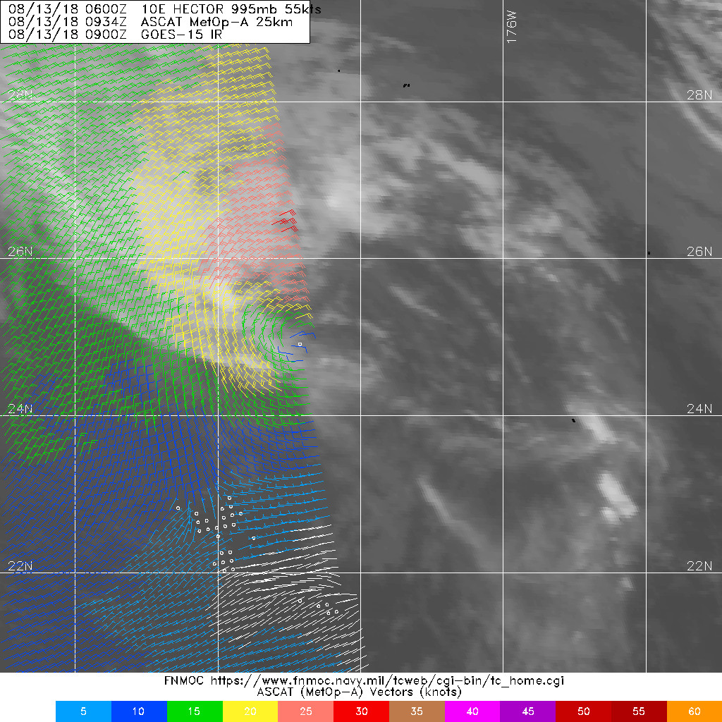
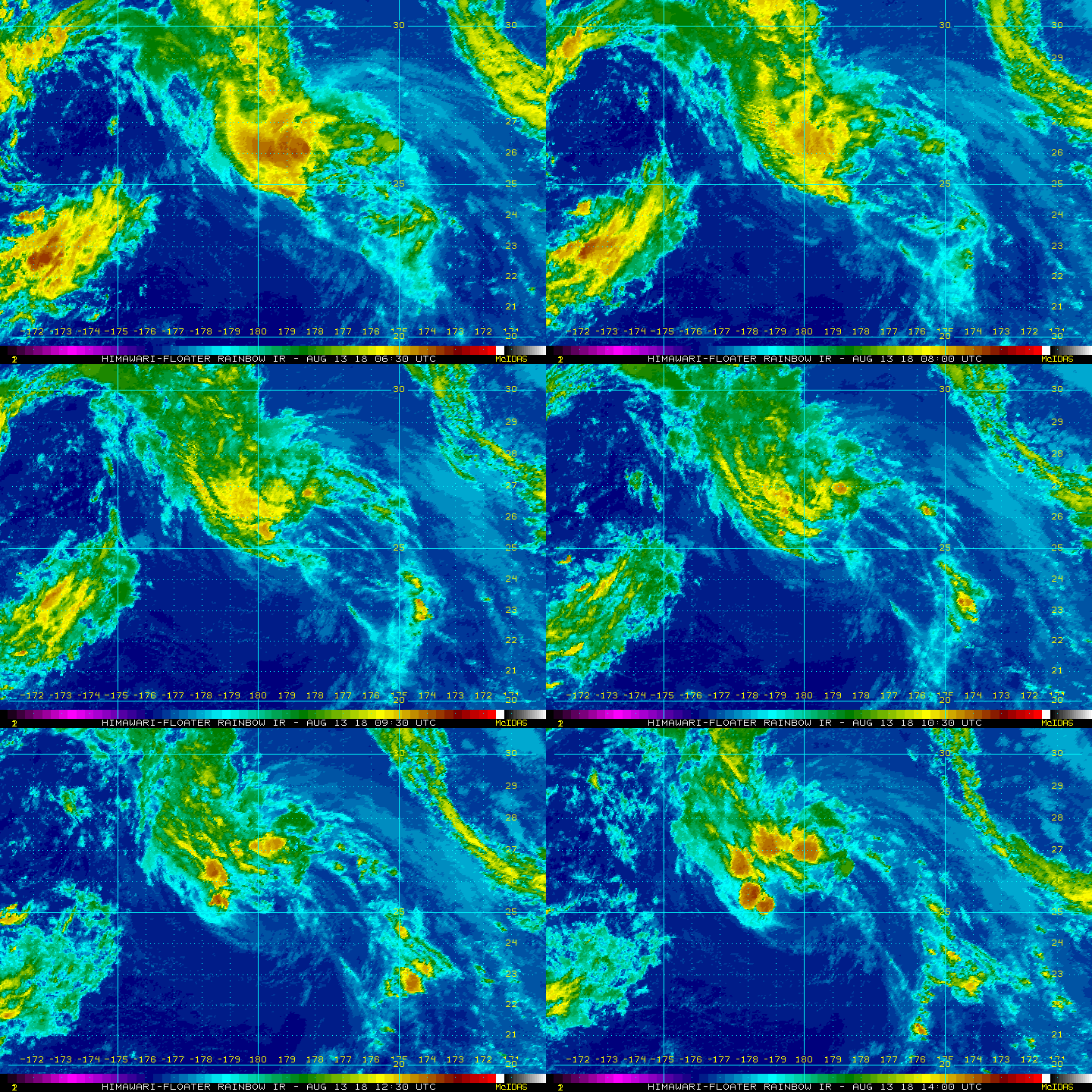
貼個完整版的CPHC最終報,15Z定位已經進入西太,JMA將接續發報。
WTPA41 PHFO 131458
TCDCP1

Tropical Storm Hector Discussion Number  53
NWS Central Pacific Hurricane Center Honolulu HI   EP102018
500 AM HST Mon Aug 13 2018

The core of Hector has been nearly devoid of deep convection since
late Sunday afternoon. The most recent estimate of vertical wind
shear from SHIPS is about 16 knots from the southwest. A few
thunderstorms have recently developed in the northwest semicircle
far from the exposed low-level circulation center (LLCC). However,
this does not appear to be enough to revive Hector in the near
future. The latest subjective Dvorak intensity estimates are
T3.0/45 knots from PHFO, SAB, and JTWC. The UW-CIMSS ADT estimate
is T2.0/30 knots. Based on all of this guidance, we are lowering
the initial intensity to 45 knots, which may be generous, for this
advisory.

Since we can easily monitor the movement of the exposed LLCC in
satellite imagery, the initial motion is set at 290/15 knots. The
track forecast has been adjusted only slightly from the previous
one. Again, the latest model guidance remains tightly clustered
through 72 hours, with the spread in the forecast tracks increasing
on Days 4 and 5. Hector is expected to continue on a west-northwest
track along the eastern periphery of a retrograding upper-level low
located west of the International Date Line near Longitude 171E. As
this low aloft continues to move west, an upper level ridge is
forecast to build north of the Hector. This will likely steer the
tropical storm toward the west-northwest during the next 48 hours. A
gradual turn toward the northwest is expected around 72 hours,
followed by a turn toward the north on days 4 and 5, as Hector
rounds the western end of the ridge. The latest forecast track
remains very close to the consensus guidance. Note that since the
system is sheared, the forecast track is also close to the TABS
through 48 hours.

The latest intensity forecast is adjusted downward due to the
continued relatively rapid weakening of Hector. The forecast
guidance shows the shear may relax within 12 to 24 hours, but the
system will likely be weaker by this time. In addition, it will be
moving over cooler sea surface temperatures. The intensity guidance
is in fairly good agreement through 36 hours, so confidence during
this portion of the forecast is fairly good. Most of the intensity
guidance levels off during the 36 through 48 hour time frame, while
the SHIPS guidance and GFS indicate some unrealistic strengthening.
The main weakening trend is during days 3 through 5. In addition,
Hector is forecast to transition to an extratropical system in about
96 hours.

Note that large breaking waves will likely persist this morning
along portions of the Northwestern Hawaiian Islands, especially
in the vicinity of Kure Atoll and Midway Atoll, due to south and
southeast swells generated by Hector.

This will be the final advisory from the Central Pacific Hurricane
Center on this system. The next bulletin will be issued by RSMC
Tokyo Japan.
For U.S. interests, see Department of Defense warnings
issued by the Joint Typhoon Warning Center in Honolulu, Hawaii.

FORECAST POSITIONS AND MAX WINDS

INIT  13/1500Z 25.3N 179.8E   45 KT  50 MPH
12H  14/0000Z 26.2N 177.4E   40 KT  45 MPH
24H  14/1200Z 27.4N 174.2E   40 KT  45 MPH
36H  15/0000Z 28.5N 171.1E   35 KT  40 MPH
48H  15/1200Z 29.9N 168.1E   35 KT  40 MPH
72H  16/1200Z 33.0N 164.0E   30 KT  35 MPH
96H  17/1200Z 37.5N 163.5E   30 KT  35 MPH...POST-TROP/EXTRATROP
120H  18/1200Z 43.5N 166.5E   25 KT  30 MPH...POST-TROP/EXTRATROP

$$
Forecaster Houston
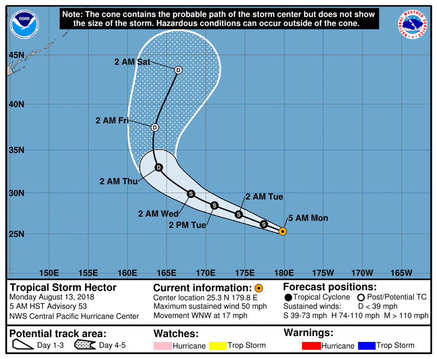
EP102018_5day_cone_with_line_53.png

LATEST.jpg

rb_lalo-animated.gif

評分

參與人數 1水氣能量 +15 收起 理由
king111807 + 15 贊一個!

查看全部評分

回復

使用道具 舉報

快速回覆
您需要登錄後才可以回帖 登錄 | 立即加入

本版積分規則

0908morakot

    主題

    帖子

    69萬

    積分

    12級[颶風Hurricane]

    Rank: 12Rank: 12Rank: 12

12級[颶風Hurricane]

發訊息

本平台僅供學術討論之用,預報應以氣象局為準

威普網站虛擬主機贊助公司

臺灣第一個天氣類型社群平台 即時天氣資訊、精準颱風動態

線上客服
FB傳送訊息
廣告行銷
精準行銷 物超所值
官方粉專
發佈 快速回復 返回頂部 返回列表