開啟輔助訪問
 找回密碼
 立即加入

1817 赫克特 耗時兩周橫跨近百經度進西太 連續7天MH破紀錄

簽到天數: 161 天

[LV.7]常住居民III

asus5635|2018-8-13 22:59 | 顯示全部樓層
THIS WILL BE THE FINAL ADVISORY FROM CENTRAL PACIFIC HURRICANE

CENTER ON THIS SYSTEM. THE NEXT BULLETIN WILL BE ISSUED BY RSMC

TOKYO JAPAN.
messageImage_1534172073505.jpg

回復

使用道具 舉報

簽到天數: 3279 天

[LV.Master]伴壇終老

t02436|2018-8-13 17:46 | 顯示全部樓層
對流大幅衰弱,09Z中心已經到179W,18Z前會進入西太,CPHC將在15Z發出責任區內最終報,18Z轉交JMA發報。
WTPA41 PHFO 130905
TCDCP1

Tropical Storm Hector Discussion Number  52
NWS Central Pacific Hurricane Center Honolulu HI   EP102018
1100 PM HST Sun Aug 12 2018

Hector's appearance has severely degraded according to satellite
imagery this evening. The low-level circulation center (LLCC) is
becoming almost entirely exposed, and the last area of deep
convection has nearly dissipated, leaving behind mainly cirrus
debris. This is not unexpected given the vertical wind shear of
11 to 14 kt from the south-southwest according to the latest
SHIPS and UW-CIMSS analyses. The most recent subjective Dvorak
intensity estimates are T3.5/55 knots from PHFO and SAB, and
T3.0/45 knots from JTWC based on a shear pattern. The UW-CIMSS ADT
estimate is T2.5/35 knots. Based on all of this guidance, we are
lowering the initial intensity to 55 knots for this advisory.

Since we can easily monitor the movement of the exposed LLCC in
satellite imagery, the initial motion is set at 295/15 knots. The
track forecast has been adjusted slightly from the previous
one. Surprisingly, the latest model guidance remains tightly
clustered through 72 hours, with the spread in the forecast tracks
increasing on Days 4 and 5. Hector is expected to continue on a
west-northwest track along the eastern periphery of a retrograding
upper-level low located just west of the International Date Line
near Longitude 173E. As this low aloft continues to move west, an
upper level ridge is forecast to build north of the Hector. This
will likely keep the tropical storm moving toward the
west-northwest during the next 48 hours. A gradual turn toward the
northwest is expected in around 72 hours, followed by a turn
toward the north on days 4 and 5, as Hector rounds the western
end of the ridge. The latest forecast track remains very close to
the consensus guidance. Note that since the system is sheared, the
forecast track is also close to the TABS through 48 hours. Based on
the latest forecast track, Hector will likely cross the
International Dateline into the Northwestern Pacific on Monday.

The latest intensity forecast is very close to the previous forecast
package. The forecast indicates additional weakening is expected
during the next 12 hours. Based on the current appearance and the
continuing southwesterly shear of 10 to 15 knots, it is likely this
will occur. The forecast guidance continues to show the shear may
relax within 18 to 24 hours, but the system will likely be weaker by
this time and will be moving over cooler sea surface temperatures.
The intensity guidance is in fairly good agreement through 36 hours,
so confidence during this portion of the forecast is fairly good.
Most of the intensity guidance levels off during the 36 through 48
hour time frame, while the SHIPS guidance and GFS indicate some
unrealistic strengthening. The main weakening trend is on days 3 and
4. In addition, Hector is forecast to transition to an extratropical
gale low in about 96 hours.

Since the current track continues to shift more toward the west, the
Tropical Storm Watch has been discontinued for Kure Atoll and Midway
Atoll. Note that large breaking waves are still likely to persist
along the Northwestern Hawaiian Islands from tonight into Monday due
to the southeast swell generated by Hector.


FORECAST POSITIONS AND MAX WINDS

INIT  13/0900Z 24.9N 178.8W   55 KT  65 MPH
12H  13/1800Z 25.9N 178.9E   50 KT  60 MPH
24H  14/0600Z 27.0N 175.9E   50 KT  60 MPH
36H  14/1800Z 28.0N 172.8E   50 KT  60 MPH
48H  15/0600Z 29.2N 169.8E   50 KT  60 MPH
72H  16/0600Z 32.0N 164.5E   45 KT  50 MPH
96H  17/0600Z 36.0N 162.5E   35 KT  40 MPH
120H  18/0600Z 42.0N 164.5E   35 KT  40 MPH...POST-TROP/EXTRATROP

$$
Forecaster Houston

EP102018_5day_cone_with_line_52.png

rbtop_lalo-animated.gif
回復

使用道具 舉報

簽到天數: 2414 天

[LV.Master]伴壇終老

0908morakot|2018-8-13 11:31 | 顯示全部樓層
JMA:SW

STORM WARNING.
EXPECTED EASTERLY WINDS 30 TO 55 KNOTS WITHIN NEXT 24 HOURS
PREVAILING OVER WATERS BOUNDED BY 30N 176E 31N 180E 26N 180E 26N 176E
30N 176E.

18081309.png

FORECAST POSITIONS AND MAX WINDS

INIT  13/0300Z 24.6N 177.0W   60 KT  70 MPH
12H  13/1200Z 25.6N 179.3W   55 KT  65 MPH
24H  14/0000Z 26.7N 177.6E   50 KT  60 MPH
36H  14/1200Z 27.8N 174.5E   50 KT  60 MPH
48H  15/0000Z 28.8N 171.4E   50 KT  60 MPH
72H  16/0000Z 31.5N 165.8E   45 KT  50 MPH
96H  17/0000Z 35.1N 162.7E   40 KT  45 MPH...POST-TROP/EXTRATROP
120H  18/0000Z 39.8N 162.8E   35 KT  40 MPH...POST-TROP/EXTRATROP

EP102018_5day_cone_with_line_51.png

LATEST.jpg

20180813.0250.himawari-8.ircolor.10E.HECTOR.60kts.988mb.24.2N.176.3W.100pc.jpg

評分

參與人數 1水氣能量 +15 收起 理由
king111807 + 15 贊一個!

查看全部評分

回復

使用道具 舉報

簽到天數: 3279 天

[LV.Master]伴壇終老

t02436|2018-8-13 00:24 | 顯示全部樓層
最後一天在中太遭遇強風切,快速減弱,預測明天18Z就會以TS強度進入西太,5天後轉化。
WTPA41 PHFO 121516
TCDCP1

Hurricane Hector Discussion Number  49
NWS Central Pacific Hurricane Center Honolulu HI   EP102018
500 AM HST Sun Aug 12 2018

Hector continues to rapidly weaken this morning due to 20 to 30
knots of south-southwesterly shear over the system as analyzed by
the latest UW-CIMSS shear analysis.
The low level circulation
center remains difficult to locate, but a couple overnight microwave
passes and an ASCAT pass were helpful in determining the center
location. The latest subjective Dvorak intensity estimates were 4.5
(77 knots) from PHFO, 4.0 (65 knots) from SAB, and 3.5 (55 knots)
from JTWC. Meanwhile, the Advanced Dvorak Technique from UW-CIMSS
was 4.4 (75 knots). The satellite presentation clearly shows that
weakening is ongoing, but given the persistent deep convection over
the low level circulation center and necessary spin down time needed
as these systems weaken, will only lower the initial intensity to 75
knots with this advisory which is on the higher side of the
intensity estimates. The initial motion is set at 305/14 knots.

The latest model guidance remains tightly clustered through 96
hours, with the spread in the track guidance increasing
considerably by 120 hours. Hector is expected to continue on a
northwest track today on the eastern periphery of an upper level low
to the west of the International Date Line. The system is expected
to make a turn to a more westerly direction tonight and continue on
this course through Wednesday as an upper level ridge builds north
of the system. A turn toward the northwest and eventually north is
then expected Wednesday night through Friday as Hector rounds the
southwest periphery of the upper level ridge. The new official
forecast track is very close to the consensus guidance as well as
the track from the previous advisory.

The intensity forecast calls for steady weakening of Hector over
the next 12 to 24 hours as the system will be in a hostile
environment under 15 to 30 knots of southwesterly shear. The shear
is forecast to decrease beyond 24 hours, but the system will likely
have weakened considerably by this time and will be moving over
marginal sea surface temperatures between 79 and 81 degrees
Fahrenheit. The intensity guidance is in fairly good agreement
through 36 hours, so confidence during this portion of the forecast
is fairly good. There is quite a bit of spread in the intensity
guidance beyond 36 hours however, with the HWRF and CTCI models
continuing to show Hector re-intensifying into a hurricane by 48
hours and holding at hurricane strength through 120 hours. This
seems really aggressive given the state the hurricane is in at the
moment and with the continued weakening forecast. As a result, the
official intensity forecast calls for steady weakening through
tonight, with Hector becoming a Tropical Storm later today or
tonight. Beyond 24 hours the forecast intensity has been held
steady, with weakening expected at the end of the forecast period as
Hector transitions over to an extratropical system.

Probabilities for tropical storm force winds reaching the
Northwestern Hawaiian Islands have decreased since the previous
advisory. If Hector continues to weaken as expected, and the
forecast track of a northwest to west-northwest motion holds true,
the Tropical Storm Watches currently in effect from Lisianski
Island to Pearl and Hermes Atoll, as well as for Midway and Kure
Atolls, may be cancelled later today.


FORECAST POSITIONS AND MAX WINDS

INIT  12/1500Z 22.8N 174.2W   75 KT  85 MPH
12H  13/0000Z 24.0N 176.2W   65 KT  75 MPH
24H  13/1200Z 25.3N 179.0W   55 KT  65 MPH
36H  14/0000Z 26.3N 178.0E   55 KT  65 MPH

48H  14/1200Z 27.2N 174.9E   55 KT  65 MPH
72H  15/1200Z 29.3N 168.4E   55 KT  65 MPH
96H  16/1200Z 32.1N 163.4E   55 KT  65 MPH
120H  17/1200Z 36.1N 161.3E   45 KT  50 MPH...POST-TROP/EXTRATROP

$$
Forecaster Jelsema

EP102018_5day_cone_with_line_49.png

LATEST.jpg

rbtop_lalo-animated.gif

GOES15002018224LeJ197.jpg
回復

使用道具 舉報

簽到天數: 161 天

[LV.7]常住居民III

asus5635|2018-8-12 14:26 | 顯示全部樓層
看起來有機會以C1強度進入西太 HECTOR10E.2018081112.Vmax.png

10E_intensity_latest.png

temp1.png

回復

使用道具 舉報

簽到天數: 601 天

[LV.9]以壇為家II

霧峰追風者|2018-8-12 13:10 | 顯示全部樓層
旁邊有一個冷心低壓,造成風切增大,風眼填塞減弱中,偏北份量也比預期多。
20180812.0430.himawari-8.ircolor.10E.HECTOR.95kts.960mb.20.8N.171.3W.100pc.jpg rgb-animated (1).gif rbtop-animated (4).gif

回復

使用道具 舉報

簽到天數: 3279 天

[LV.Master]伴壇終老

t02436|2018-8-12 00:17 | 顯示全部樓層
中心越過西經170度,開始轉往西北方向移動,受風切影響強度將持續減弱,目前預測明(13)日深夜以C1下限附近強度進入西太。
WTPA41 PHFO 111518 CCA
TCDCP1

Hurricane Hector Discussion Number  45
NWS Central Pacific Hurricane Center Honolulu HI   EP102018
500 AM HST Sat Aug 11 2018

Hector's ragged and cloud-filled eye is surrounded by a nearly solid
ring of very cold cloud tops, but the overall structure of the
cyclone is diminishing. Outflow has become increasingly restricted
in the southern semicircle as Hector moves closer to southerly shear
associated with a developing low aloft to the west-northwest.
Subjective Dvorak current intensity estimates from HFO/SAB/PGTW
ranged from 5.5/105 kt to 6.0/115 kt, while Final-T numbers were as
low as 4.5/77 kt. Based on a blend of these values, and the
assumption that a weakening of a cyclone's wind field will lag the
satellite presentation, the initial intensity for this advisory is
maintained at 105 kt.

The initial motion estimate for this advisory is 300/10 kt. The
steering environment is characterized by a mid-level ridge to the
northeast and a mid- to upper-level low to the northwest. As the
ridge remains stationary and the low becomes better developed, a
slight turn toward the northwest is expected in the short term, with
an increase in forward speed. By Monday, the ridge will build to the
north of Hector, inducing a slight turn toward the west that will
persist until the end of the forecast period, at which time Hector
is expected to make a turn back toward the northwest. The updated
forecast track was once again nudged to the left of the previous
forecast and lies close to HWFI/TVCN guidance. Note that FSSE
guidance appears to have problems with the International Date Line
that is causing errors with the tracker.

A fairly rapid rate of weakening is expected over the next 36 hours
as south to southwesterly shear increases to near 30 kt, with a
slower rate of weakening expected thereafter as shear relaxes.
After
24 hours, SSTs along the forecast track will steadily decrease from
the current 28C, but are still expected to be near 26C on day 3, and
near 25C on day 5.
With weaker shear beyond 36 hours, SHIPS
indicates little change in intensity, keeping Hector a minimal
hurricane through day 5. The HWRF indicates the upcoming shear
increase will weaken Hector to a minimal tropical storm within 48
hours before it re-intensifies on days 4 and 5. The official
forecast is close to the previous forecast and closely follows the
IVCN consensus, with increased guidance spread in the later forecast
periods leading to decreased confidence.

Given the close approach to the Northwestern Hawaiian Islands on
Sunday and Monday, a Tropical Storm Watch remains posted for the
area from Lisianski Island to Pearl and Hermes Atoll. Interests on
Midway and Kure Atolls should continue to monitor the progress of
Hector.


FORECAST POSITIONS AND MAX WINDS

INIT  11/1500Z 19.3N 170.1W  105 KT 120 MPH
12H  12/0000Z 20.5N 171.6W   90 KT 105 MPH
24H  12/1200Z 22.2N 174.0W   80 KT  90 MPH
36H  13/0000Z 23.7N 176.6W   70 KT  80 MPH
48H  13/1200Z 24.8N 179.3W   65 KT  75 MPH
72H  14/1200Z 26.6N 174.9E   60 KT  70 MPH

96H  15/1200Z 29.0N 169.0E   55 KT  65 MPH
120H  16/1200Z 32.0N 164.0E   50 KT  60 MPH

$$

Forecaster Birchard

EP102018_5day_cone_with_line_45.png

rbtop_lalo-animated.gif

2018EP10_16KMGWVP_201808111500.GIF

2018EP10_OHCNFCST_201808111200.GIF

sst.gif

wg9sht.GIF
回復

使用道具 舉報

簽到天數: 3279 天

[LV.Master]伴壇終老

t02436|2018-8-10 21:21 | 顯示全部樓層
重回C4,預估還會再稍微增強,即將開始轉向西北方向移動。
WTPA41 PHFO 100915
TCDCP1

Hurricane Hector Discussion Number  40
NWS Central Pacific Hurricane Center Honolulu HI   EP102018
1100 PM HST Thu Aug 09 2018

Hector continues to be a very impressive hurricane this evening.
The distinct eye has warmed, while the cloud top temperatures in
the surrounding eyewall have cooled. As a result, all of the
satellite fix agencies (PHFO, SAB and JTWC) provided subjective
Dvorak intensity estimates of T6.0/115 kt. In addition, the UW/CIMSS
ADT increased to T6.0/115 kt. Based on all of this guidance, the
initial intensity has been increased to 115 kt.

Hector's latest movement is 280/14 kt. The hurricane continues to
move just north of due west to the south of a mid-level ridge. The
western end of the ridge is forecast to weaken as a low pressure
system develops near the International Dateline during the next day
or two. This is expected to result in a gradual turn toward the
west-northwest on Friday, followed by a more northwestward track
from Friday night through this weekend. The forecast mostly follows
the previous advisory package though 48 hours. After that, the
latest forecast track was shifted slightly north from days 3 through
5. These subtle changes in the track were due to nudging toward the
HWRF, as well as the consensus models, such as TVCN and GFEX.

The latest intensity forecast, which is close to the previous
forecast beyond 12 hours, indicates additional slight
intensification through Friday morning. After that, we are expecting
gradual weakening from late Friday through Saturday evening. The
weakening trend is more significant beyond 48 hours as Hector moves
into an area of increasing vertical wind shear, as well as cooler
water temperatures. The current intensity forecast is also in line
with HWRF, HMON, and CTC2, which have verified the best so far.
These models also show a faster weakening after 48 hours, but the
forecast shows a more conservative weakening trend for now.

A Tropical Storm Watch remains in effect for Johnston Island. If the
expected turn toward the west-northwest does not occur, tropical
storm conditions are possible there starting late Friday. Elsewhere,
interests in the Northwestern Hawaiian Islands, including Midway and
Kure Atolls and the Papahanaumokuakea Marine National Monument west
of French Frigate Shoals should monitor the progress of Hector.
Based on the latest forecast, Tropical Storm or Hurricane Watches
may be needed for these islands by late Friday.


FORECAST POSITIONS AND MAX WINDS

INIT  10/0900Z 17.4N 164.4W  115 KT 130 MPH
12H  10/1800Z 17.9N 166.5W  120 KT 140 MPH
24H  11/0600Z 18.9N 168.7W  115 KT 130 MPH
36H  11/1800Z 20.3N 170.5W  110 KT 125 MPH
48H  12/0600Z 22.4N 172.9W   95 KT 110 MPH
72H  13/0600Z 26.5N 177.5W   70 KT  80 MPH
96H  14/0600Z 30.5N 177.5E   50 KT  60 MPH

120H  15/0600Z 33.5N 174.5E   45 KT  50 MPH

$$
Forecaster Houston
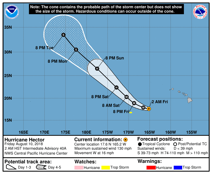
EP102018_5day_cone_with_line_40A.png

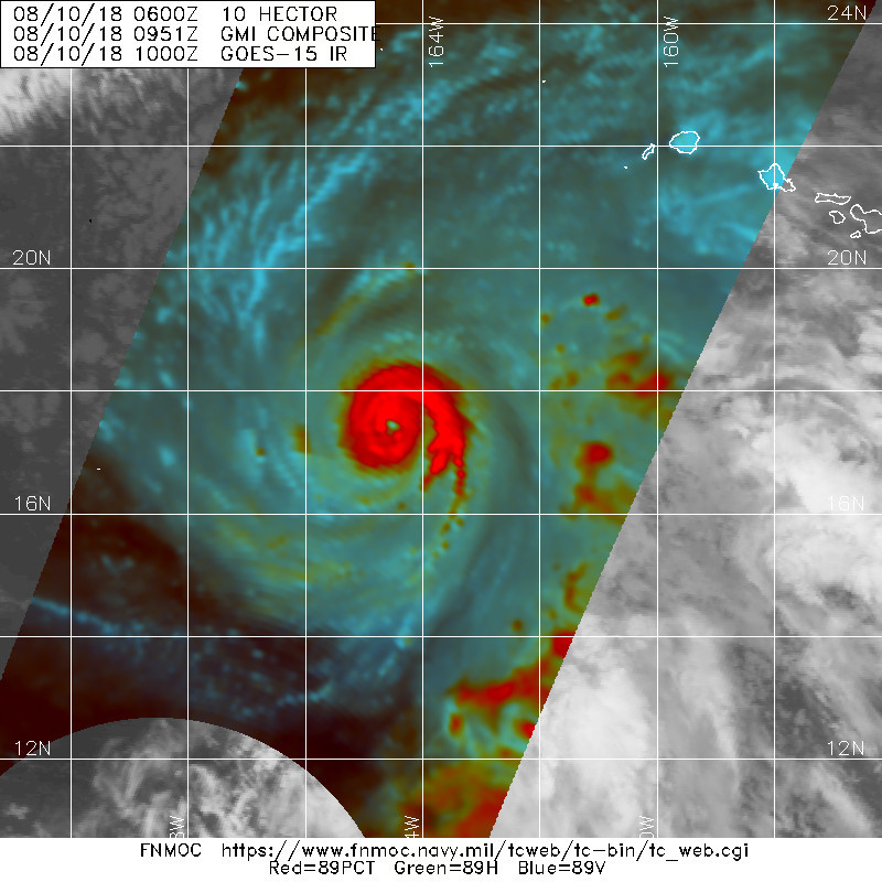
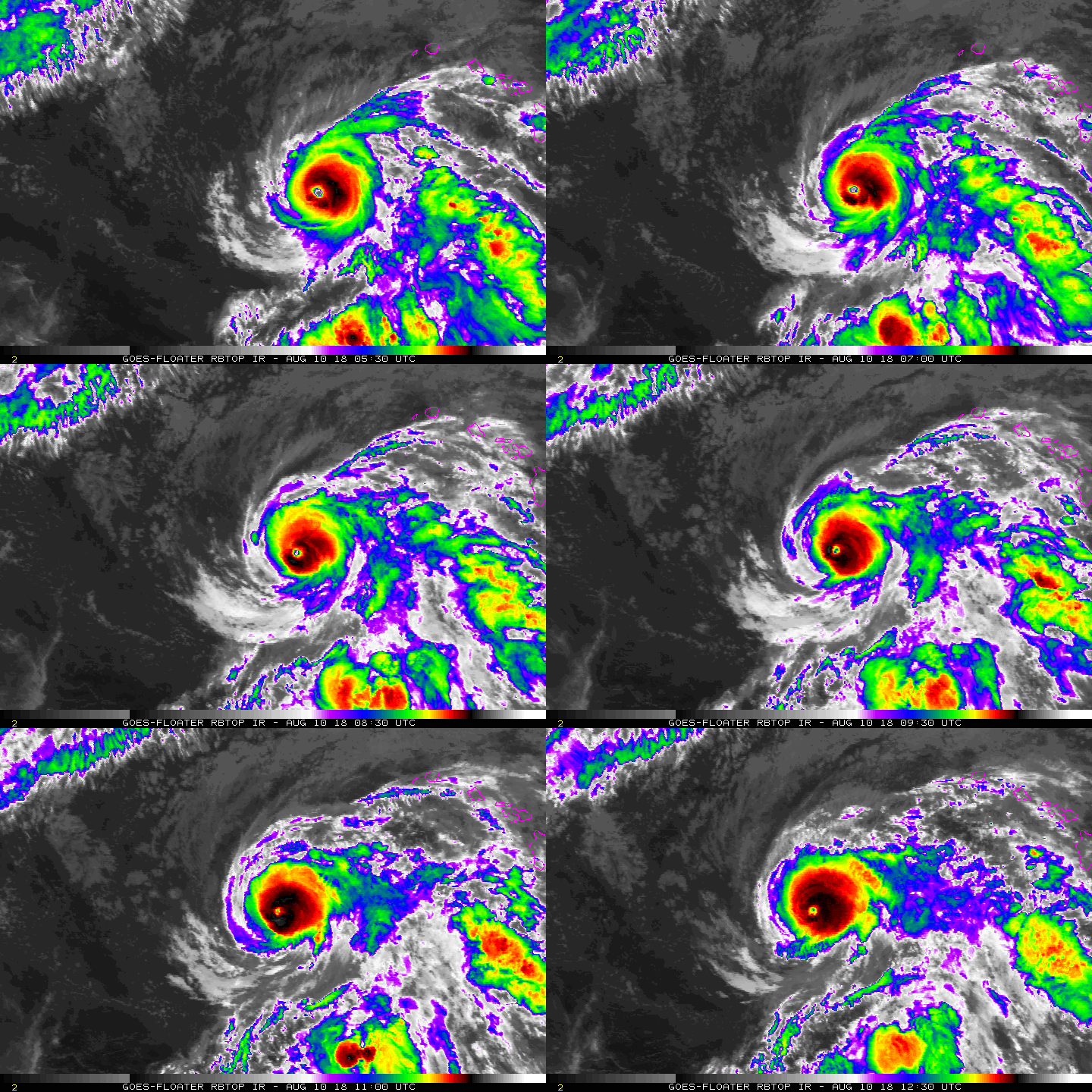
20180810.0951.gpm.89pct89h89v.10E.HECTOR.115kts.951mb.17.2N.163.7W.060pc.jpg

rbtop-animated.gif

12Z速報維持115節評價。
10E HECTOR 180810 1200 17.6N 165.2W EPAC 115 951

回復

使用道具 舉報

快速回覆
您需要登錄後才可以回帖 登錄 | 立即加入

本版積分規則

本平台僅供學術討論之用,預報應以氣象局為準

威普網站虛擬主機贊助公司

臺灣第一個天氣類型社群平台 即時天氣資訊、精準颱風動態

線上客服
FB傳送訊息
廣告行銷
精準行銷 物超所值
官方粉專
發佈 快速回復 返回頂部 返回列表