開啟輔助訪問
 找回密碼
 立即加入

05L.Ernesto 今年第三個副熱帶風暴 高緯轉TS

簽到天數: 2414 天

[LV.Master]伴壇終老

2018-8-12 21:15 | 顯示全部樓層
  熱帶風暴  
編號:05 L
名稱:Ernesto

  基本資料  
擾動編號日期:2018 08 12 21
命名日期  :2018 08 15 23
撤編日期  :2018 08 00 00
登陸地點  :

  巔峰時期資料  
近中心最強風速
國家颶風中心(NHC):40 kts
海平面最低氣壓1007 百帕

  過去路徑圖  


  擾動編號資料  
98L.INVEST.25kts.1016mb.39.5N.53.3W

20180812.1230.msg-4.ir.98L.INVEST.25kts.1016mb.39.5N.53.3W.100pc.jpg

  NHC:10%  
1. A non-tropical low pressure system located about 500 miles south
of Cape Race, Newfoundland is producing disorganized showers and
thunderstorms to the south of its center of circulation.  This low
could gradually acquire subtropical or tropical characteristics
through the middle of the week while it meanders over the central
subtropical Atlantic Ocean.
* Formation chance through 48 hours...low...10 percent.
* Formation chance through 5 days...low...20 percent.

two_atl_2d1.png

以上資料來自:NHC颱風論壇整理製作

評分

參與人數 1水氣能量 +15 +1 收起 理由
king111807 + 15 + 1 熱帶擾動首帖

查看全部評分

回復

使用道具 舉報

簽到天數: 601 天

[LV.9]以壇為家II

霧峰追風者|2018-8-14 14:49 | 顯示全部樓層
NHC 展望提升至40%。
1. A non-tropical low pressure system located about 700 miles south
of Cape Race, Newfoundland, is producing a large area of cloudiness
and disorganized thunderstorms mainly to the east of the center.
Environmental conditions are forecast to become a somewhat more
conducive for some subtropical or tropical development by Wednesday.
The system is forecast to move northeastward over the colder waters
of the North Atlantic by late Thursday or Friday, which should limit
any additional development.
* Formation chance through 48 hours...medium...40 percent.
* Formation chance through 5 days...medium...40 percent.
two_atl_2d1.png 20180814.0600.msg-4.ir.98L.INVEST.25kts.1013mb.36.7N.51.4W.100pc.jpg 98L_gefs_latest.png

回復

使用道具 舉報

簽到天數: 3279 天

[LV.Master]伴壇終老

t02436|2018-8-15 23:51 | 顯示全部樓層
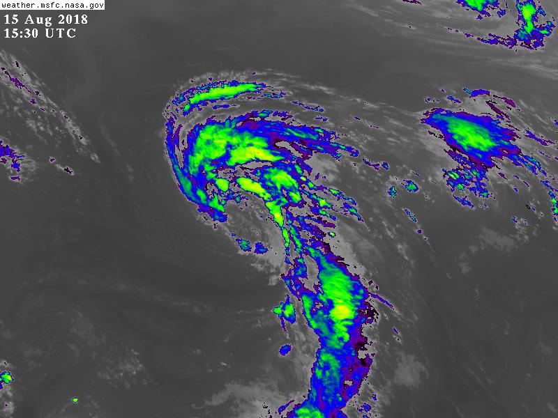
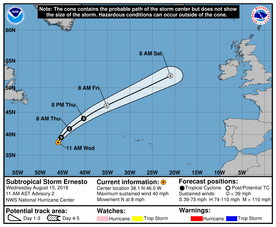
直接命名Ernesto,今年第3個副熱帶風暴。
805
WTNT45 KNHC 151501 CCA
TCDAT5

Subtropical Storm Ernesto Discussion Number   2...Corrected
NWS National Hurricane Center Miami FL       AL052018
1100 AM AST Wed Aug 15 2018

Convection associated with the subtropical cyclone became better
organized after the release of the previous advisory, but
cloud tops have warmed recently with the convection becoming
somewhat fragmented.  An Hebert-Poteat subtropical classification of
T2.5 from TAFB suggests that they system is producing gale-force
winds, and recent scatterometer data that passed over the far
eastern portion of the circulation revealed 30-kt winds. Since the
instrument missed the radius of maximum winds, it is assumed that
stronger winds exist over the eastern portion of the circulation,
and the initial intensity is increased to 35 kt, making the system
a subtropical storm.

Ernesto has about 24 hours over marginally warm SSTs and in a low-
shear environment in which to strengthen.  After that time, the
cyclone will be moving over much colder water which should cause it
to become post-tropical within 48 hours. The post-tropical cyclone
is forecast to merge with a frontal zone associated with a larger
extratropical cyclone over the North Atlantic in 3 to 4 days.

The cyclone is moving northward at about 6 kt. A mid-level trough
that is moving off the east coast of the United States should cause
Ernesto to turn north-northeastward later today, and the cyclone is
forecast to accelerate northeastward by late Thursday as it becomes
embedded within the mid-latitude westerlies. The dynamical model
guidance continues to be in good agreement, and the new NHC track
forecast remains in the middle of the guidance envelope.


FORECAST POSITIONS AND MAX WINDS

INIT  15/1500Z 38.1N  46.0W   35 KT  40 MPH
12H  16/0000Z 39.3N  45.3W   40 KT  45 MPH
24H  16/1200Z 41.3N  43.5W   45 KT  50 MPH
36H  17/0000Z 43.6N  40.3W   45 KT  50 MPH
48H  17/1200Z 46.4N  35.2W   45 KT  50 MPH...POST-TROPICAL
72H  18/1200Z 52.3N  21.0W   40 KT  45 MPH...POST-TROPICAL
96H  19/1200Z...MERGED WITH LARGER EXTRATROPICAL LOW

$$
Forecaster Brown
145347_5day_cone_with_line.png

GOES15302018227SPvq4G.jpg
回復

使用道具 舉報

簽到天數: 601 天

[LV.9]以壇為家II

霧峰追風者|2018-8-17 06:06 | 顯示全部樓層
NHC 判定轉為熱帶風暴,趨向愛爾蘭。
307
WTNT45 KNHC 162034
TCDAT5

Tropical Storm Ernesto Discussion Number   7
NWS National Hurricane Center Miami FL       AL052018
500 PM AST Thu Aug 16 2018

Visible and infrared satellite imagery shows that convective
banding has increased closer to the center of Ernesto today.  The
system has also lost much of its outer cloud bands and is no longer
co-located with an upper-level low.  On this basis, Ernesto is now
being classified as a tropical storm. The initial intensity remains
40 kt, which is based on recent satellite estimates and the earlier
ASCAT data.  Although the cyclone is forecast to move over cooler
waters and become post-tropical very soon, the global models deepen
the system somewhat due to baroclinic processes. In addition, the
expected increase in the cyclone's forward speed is likely to result
in an increase in the wind speed.  The new NHC intensity forecast
calls for slight strengthening over the next 12-24 hours, with
little overall change in intensity thereafter.  The system is still
predicted to merge with a frontal zone as it approaches Ireland and
the United Kingdom late Saturday or Saturday night.

Ernesto continues to accelerate northeastward and is now moving
045/16 kt.  The cyclone should accelerate further while moving
northeastward to east-northeastward within the mid-latitude
westerlies over the next day or two. The dynamical model guidance
remains tightly clustered and little change was made to the
previous NHC track forecast.


FORECAST POSITIONS AND MAX WINDS

INIT  16/2100Z 43.0N  41.0W   40 KT  45 MPH
12H  17/0600Z 44.9N  37.6W   45 KT  50 MPH...POST-TROPICAL
24H  17/1800Z 47.7N  31.4W   45 KT  50 MPH...POST-TROPICAL
36H  18/0600Z 50.2N  23.8W   45 KT  50 MPH...POST-TROP/EXTRATROP
48H  18/1800Z 52.0N  15.8W   40 KT  45 MPH...POST-TROP/EXTRATROP
72H  19/1800Z...MERGED WITH FRONTAL ZONE

$$
Forecaster Brown
203633_5day_cone_no_line_and_wind.png

回復

使用道具 舉報

快速回覆
您需要登錄後才可以回帖 登錄 | 立即加入

本版積分規則

0908morakot

    主題

    帖子

    69萬

    積分

    12級[颶風Hurricane]

    Rank: 12Rank: 12Rank: 12

12級[颶風Hurricane]

發訊息

本平台僅供學術討論之用,預報應以氣象局為準

威普網站虛擬主機贊助公司

臺灣第一個天氣類型社群平台 即時天氣資訊、精準颱風動態

線上客服
FB傳送訊息
廣告行銷
精準行銷 物超所值
官方粉專
發佈 快速回復 返回頂部 返回列表