開啟輔助訪問
 找回密碼
 立即加入

05L.Dorian 年度風王 巔峰強襲巴哈馬群島

簽到天數: 1650 天

[LV.Master]伴壇終老

2019-8-23 19:46 | 顯示全部樓層
  基本資料  
編號    :05 L
擾動編號日期:2019 08 23 19
撤編日期  :2019 09 10 10
99L INVEST 190823 0600 9.5N 40.5W ATL 20 1012

20190823.1120.goes-16.ir.99L.INVEST.15kts.1006mb.10N.41.5W.100pc.jpg

  NHC:10%  
2. Showers and thunderstorms have increased since yesterday in
association with a tropical wave located about 1400 miles
east-southeast of the Windward Islands.  Additional slow development
of this system is possible during the next few days as it moves
generally westward at about 15 mph.
* Formation chance through 48 hours...low...10 percent.
* Formation chance through 5 days...low...20 percent.

two_atl_2d20823.png
two_atl_5d20823.png

-MAX:160KT 911hPa
-猛爆增強登年度風王 強襲巴哈馬群島

評分

參與人數 1水氣能量 +15 +1 收起 理由
king111807 + 15 + 1 熱帶擾動首帖

查看全部評分

回復

使用道具 舉報

簽到天數: 582 天

[LV.9]以壇為家II

蜜露|2019-10-29 21:30 | 顯示全部樓層


颶風獵人在巴哈馬追擊颶風Dorian   160Kts !!!!!! 這樣的直擊.


回復

使用道具 舉報

簽到天數: 53 天

[LV.5]常住居民I

天篷大元帥|2019-9-9 11:53 | 顯示全部樓層
國家颶風中心在9日3時發出最後一報
000
WTNT35 KNHC 090242
TCPAT5

BULLETIN
Post-Tropical Cyclone Dorian Advisory Number  64
NWS National Hurricane Center Miami FL       AL052019
1100 PM AST Sun Sep 08 2019

...POST-TROPICAL DORIAN MOVES OVER THE COLD WATERS OF THE
LABRADOR SEA AND BECOMES FULLY EXTRATROPICAL...
...THIS IS THE LAST ADVISORY...


SUMMARY OF 1100 PM AST...0300 UTC...INFORMATION
-----------------------------------------------
LOCATION...52.1N 53.4W
ABOUT 375 MI...600 KM N OF CAPE RACE NEWFOUNDLAND
MAXIMUM SUSTAINED WINDS...60 MPH...95 KM/H
PRESENT MOVEMENT...ENE OR 60 DEGREES AT 24 MPH...39 KM/H
MINIMUM CENTRAL PRESSURE...980 MB...28.94 INCHES


WATCHES AND WARNINGS
--------------------
CHANGES WITH THIS ADVISORY:

The Canadian Hurricane Center has discontinued all tropical cyclone
warnings for Atlantic Canada.

SUMMARY OF WATCHES AND WARNINGS IN EFFECT:

There are no coastal watches or warnings in effect.


DISCUSSION AND OUTLOOK
----------------------
At 1100 PM AST (0300 UTC), the center of Post-Tropical Cyclone
Dorian was located near latitude 52.1 North, longitude 53.4 West.
The post-tropical cyclone is moving toward the east-northeast near
24 mph (39 km/h) and this motion is forecast to continue through
Tuesday.  On the forecast track, the center of the post-tropical
cyclone Dorian will continue to move away from Atlantic Canada
through Tuesday.

Maximum sustained winds are near 60 mph (95 km/h) with higher gusts.
Some weakening is forecast during the next 48 hours, and the
post-tropical cyclone is forecast to be absorbed by a larger low
pressure system on Tuesday.

Tropical-storm-force winds extend outward up to 415 miles (665 km)
from the center.

The estimated minimum central pressure is 980 mb (28.94 inches).


HAZARDS AFFECTING LAND
----------------------
WIND: Tropical-storm-force wind gusts will continue across portions
of southeastern Newfoundland until early Monday and then diminish by
late Monday morning.

STORM SURGE: Storm surge along the northeastern Gulf of St. Lawrence
and the West Coast of Newfoundland will continue to subside through
Monday morning.

RAINFALL:  Dorian is expected to produce rainfall accumulations of
less than 1 inch across far eastern Quebec into Newfoundland and
Labrador.

SURF:  Large swells are affecting the coast of Atlantic Canada, and
they will continue to affect that area during the next couple of
days. Swells along the mid-Atlantic and New England coasts of the
U.S. will continue for another day or so.  These swells are likely
to cause life-threatening surf and rip current conditions. Please
consult products from your local weather office.


NEXT ADVISORY
-------------
This is the last public advisory issued by the National Hurricane
Center on this system.  Additional information on this system can be
found in High Seas Forecasts issued by the National Weather Service,
under AWIPS header NFDHSFAT1, WMO header FZNT01 KWBC, and online at
ocean.weather.gov/shtml/NFDHSFAT1.php.


$$
Forecaster Stewart

上為國家颶風中心報文原文,下為機器翻譯(機器翻譯僅供參考,實際以原文為主)


000
WTNT35 KNHC 090242
TCPAT5

公告
後熱帶氣旋Dorian諮詢編號64
NWS國家颶風中心邁阿密佛羅里達州AL052019
1100 PM AST Sun Sep 08 2019

...熱帶
多利亞人在拉斯維加斯海域的冷水中移動並成為完全超級的。
...這是最後的諮詢...


摘要1100 PM AST ... 0300 ... UTC信息
------------------------ -----------------------
位置... 52.1N 53.4W
關於375 MI ... 600 KM N CAPE RACE NEWFOUNDLAND
最大持續風... 60英里/小時... 95公里/小時
現在運動... ENE或60度24馬力... 39公里/小時
最低中壓... 980 MB ... 28.94英寸


手錶和警告
--------------------本消息的
變化:

加拿大颶風中心已停止
加拿大大西洋沿岸的所有熱帶氣旋警告。

手錶和警告的概要:

沒有沿海手錶或警告有效。


討論和展望
----------------------
在AST下午11點(0300 UTC),後熱帶氣旋
多里安中心位於北緯52.1度,經度53.4西。
後熱帶氣旋正以
24英里/小時(39公里/小時)的速度向東北東北方向移動,預計這一運動將持續到
週二。在預測軌道上,後熱帶的中心
颶風多利安將
在周二繼續遠離加拿大大西洋。

最大持續風速接近60英里/小時(95公里/小時),陣風較高。
預計在接下來的48小時內將出現一些減弱,預計
週二
熱帶氣旋將被更大的低壓系統吸收。

熱帶風暴強風
從中心向外延伸至415英里(665公里)。

估計的最小中心壓力為980 mb(28.94英寸)。


影響土地的危險
----------------------
風:熱帶風暴強風陣風將持續穿越
紐芬蘭東南部的部分地區,直至週一早些時候,然後
在周一晚些時候減少早上。

風暴潮:沿著聖勞倫斯灣東北部
和紐芬蘭西海岸的風暴潮將在
周一早上繼續消退。

降雨:多利安預計將
在魁北克省東部地區向紐芬蘭和
拉布拉多產生不到1英寸的降雨量。

SURF:大浪湧正在影響加拿大大西洋沿岸,並且
在接下來的
幾天內它們將繼續影響該地區。沿美國大西洋中部和新英格蘭海岸的海浪
將持續一天左右。這些膨脹可能
會導致危及生命的衝浪和裂口潮流。請
諮詢當地氣象辦公室的產品。


下一個顧問
-------------
這是國家颶風
中心就該系統發布的最後一次公開諮詢。有關該系統的更多信息,請
參見國家氣象局發布的公海預報,
AWIPS標題為NFDHSFAT1,WMO標題為FZNT01 KWBC,在線為
ocean.weather.gov/shtml/NFDHSFAT1.php。


$$
Forecaster斯圖爾特

回復

使用道具 舉報

簽到天數: 53 天

[LV.5]常住居民I

天篷大元帥|2019-9-8 15:43 | 顯示全部樓層
轉化後,美國國家颶風中心仍持續發報,以前有這樣過嗎?
000
WTNT45 KNHC 080233
TCDAT5

Post-Tropical Cyclone Dorian Discussion Number  60
NWS National Hurricane Center Miami FL       AL052019
1100 PM AST Sat Sep 07 2019

The center of Post-Tropical Cyclone Dorian made landfall near
Sambro Creek, Nova Scotia several hours ago. Since then, the
powerful cyclone has continued to move rapidly to the
north-northeast and is now just east of Prince Edward Island.  The
wind field has expanded considerably, and the cyclone is producing
tropical-storm-force winds over an extensive area of the Canadian
Maritimes.  The powerful cyclone is expected to continue with a
large wind field, but gradual weakening is anticipated as forecast
by most of the global models.

The best estimate of the initial motion is toward the north-
northeast at 23 kt. Since the cyclone is embedded within the fast
extratropical westerly flow, this general track with a turn to
the northeast is anticipated until dissipation in about 2 days.
Track guidance is in very good agreement with this motion, and the
NHC forecast follows the guidance envelope.

The Ocean Prediction Center (OPC) provided guidance to prepare
this forecast.

The National Hurricane Center will continue to issue advisories on
Dorian as a post-tropical cyclone until the threat to eastern
Canada has ended.


Key Messages:

1. Dorian will continue to have significant impacts in portions
of eastern Canada overnight and Sunday. Dangerous storm surge
impacts are likely in portions of the Gulf of St. Lawrence,
southwestern Newfoundland and eastern Nova Scotia.  Hurricane-force
winds are still occurring in Nova Scotia and are forecast to occur
in Newfoundland overnight. Refer to information from the Canadian
Hurricane Centre for more information on these hazards.


FORECAST POSITIONS AND MAX WINDS

INIT  08/0300Z 46.3N  62.1W   80 KT  90 MPH...POST-TROPICAL
12H  08/1200Z 49.0N  60.0W   70 KT  80 MPH...POST-TROP/EXTRATROP
24H  09/0000Z 52.0N  54.5W   55 KT  65 MPH...POST-TROP/EXTRATROP
36H  09/1200Z 54.5N  48.0W   45 KT  50 MPH...POST-TROP/EXTRATROP
48H  10/0000Z 56.0N  41.0W   40 KT  45 MPH...POST-TROP/EXTRATROP
72H  11/0000Z...DISSIPATED

$$
Forecaster Avila
上為國家颶風中心報文原文,下為機器翻譯(機器翻譯僅供參考,實際以原文為主)
000
WTNT45 KNHC 080233
TCDAT5

後熱帶氣旋多里安討論第60號
NWS National Hurricane Center Miami FL AL052019
晚上11點,星期六,2019年7月7日

後熱帶氣旋多里安中心登陸附近
幾個小時前,新斯科舍省Sambro Creek。從那以後,
強大的旋風繼續迅速向
東北偏北,現在位於愛德華王子島以東。該
風場大大擴展,旋風正在產生
熱帶風暴強風肆虐加拿大廣大地區
濱海。強大的旋風預計將持續下去
大風場,但預計會逐漸減弱
大部分全球模特。

對初始運動的最佳估計是朝向北方 -
東北23千噸。由於旋風器嵌入在快速內
溫帶西風流,這個一般的軌道轉向
預計東北部將在大約2天內消散。
跟踪指導與此動議非常一致,並且
NHC預測遵循指導範圍。

海洋預測中心(OPC)為準備工作提供了指導
這個預測。

國家颶風中心將繼續發布諮詢意見
多利安作為後熱帶氣旋直到東部受到威脅
加拿大已經結束。


關鍵信息:

多利安將繼續對部分產生重大影響
加拿大東部一夜之間和周日。危險的風暴潮
影響很可能在聖勞倫斯灣的部分地區,
紐芬蘭西南部和新斯科舍省東部。颶風力
新斯科舍省仍然存在風,預計會發生
在紐芬蘭一夜之間。請參閱加拿大的信息
颶風中心了解有關這些危害的更多信息。


預測位置和最大風

INIT 08 / 0300Z 46.3N 62.1W 80 KT 90 MPH ...熱帶地區
12H 08 / 1200Z 49.0N 60.0W 70 KT 80 MPH ... POST-TROP / EXTRATROP
24H 09 / 0000Z 52.0N 54.5W 55 KT 65 MPH ... POST-TROP / EXTRATROP
36H 09 / 1200Z 54.5N 48.0W 45 KT 50 MPH ...後滴/外接
48H 10 / 0000Z 56.0N 41.0W 40 KT 45 MPH ... POST-TROP / EXTRATROP
72H 11 / 0000Z ......已棄用

$$
預報員阿維拉


回復

使用道具 舉報

簽到天數: 3279 天

[LV.Master]伴壇終老

t02436|2019-9-8 09:54 | 顯示全部樓層
21Z報判定為後熱帶氣旋
ZCZC MIATCDAT5 ALL
TTAA00 KNHC DDHHMM

Post-Tropical Cyclone Dorian Discussion Number  59
NWS National Hurricane Center Miami FL       AL052019
500 PM AST Sat Sep 07 2019

Satellite imagery and surface observations indicate that Dorian has
lost tropical cyclone characteristics and is now a hurricane-force
extratropical low.
  The initial intensity is held at 85 kt based
mainly on the earlier scatterometer data.

The initial motion is 040/26.  Strong mid-latitude southwesterly
flow should steer Dorian across Nova Scotia and other portions of
eastern Canada during the next 24-30 h.  After that, the cyclone
should turn east-northeastward over the far north Atlantic, with
this motion continuing for the rest of the system's life.

Global model guidance indicates that the post-tropical cyclone
should gradually weaken as it moves across eastern Canada, and the
new intensity forecast brings the winds below hurricane force by 24
h.  Additional weakening should then occur until the storm is
absorbed by a large extratropical low to its north.

The National Hurricane Center will continue to issue advisories on
Dorian as a post-tropical cyclone until the threat to eastern
Canada has ended.


Key Messages:

1. Although Dorian has lost tropical cyclone characteristics, it
will have significant impacts in portions of eastern Canada tonight
and Sunday. Dangerous storm surge impacts are likely in portions of
the Gulf of St. Lawrence, southwestern Newfoundland and eastern Nova
Scotia.  Hurricane-force winds are also likely in Nova Scotia,
Prince Edward Island and Newfoundland later today and tonight. Refer
to information from the Canadian Hurricane Centre for more
information on these hazards.


FORECAST POSITIONS AND MAX WINDS

INIT  07/2100Z 43.9N  63.9W   85 KT 100 MPH...POST-TROPICAL
12H  08/0600Z 47.0N  61.1W   70 KT  80 MPH...POST-TROP/EXTRATROP
24H  08/1800Z 50.2N  56.9W   60 KT  70 MPH...POST-TROP/EXTRATROP
36H  09/0600Z 53.0N  50.9W   50 KT  60 MPH...POST-TROP/EXTRATROP
48H  09/1800Z 55.4N  43.7W   45 KT  50 MPH...POST-TROP/EXTRATROP
72H  10/1800Z...DISSIPATED

$$
Forecaster Beven

NNNN

al052019.20190907211901.gif

2215Z登陸加拿大新斯科舍
ZCZC MIATCUAT5 ALL
TTAA00 KNHC DDHHMM

Post-Tropical Cyclone Dorian Tropical Cyclone Update
NWS National Hurricane Center Miami FL       AL052019
705 PM AST Sat Sep 07 2019

...DORIAN MAKES LANDFALL OVER NOVA SCOTIA...

Satellite and surface observations indicate that the center of
Dorian has made landfall at 615 PM AST (2215 UTC) near Sambro Creek
in Nova Scotia, Canada, or about 15 miles (25 km) south of Halifax.

The estimated maximum sustained winds at landfall were 100 mph (155
km/h), and the estimated central pressure was 958 mb (28.29 inches).


SUMMARY OF 705 PM AST...2305 UTC...INFORMATION
----------------------------------------------
LOCATION...44.7N 63.4W
ABOUT 15 MI...25 KM NE OF HALIFAX NOVA SCOTIA
MAXIMUM SUSTAINED WINDS...100 MPH...155 KM/H
PRESENT MOVEMENT...NE OR 35 DEGREES AT 30 MPH...48 KM/H
MINIMUM CENTRAL PRESSURE...958 MB...28.29 INCHES

$$
Forecaster Blake/Avila


NNNN

234651_5day_cone_with_line.png

20190908.0120.goes-16.ircolor.05L.DORIAN.80kts.960mb.45.2N.62.9W.100pc.jpg
回復

使用道具 舉報

簽到天數: 3279 天

[LV.Master]伴壇終老

t02436|2019-9-8 00:12 | 顯示全部樓層
逐漸轉化中,中心已在近岸,即將以颶風強度登陸。
000
WTNT45 KNHC 071452
TCDAT5

Hurricane Dorian Discussion Number  57
NWS National Hurricane Center Miami FL       AL052019
1100 AM AST Sat Sep 07 2019

Satellite imagery this morning indicates that Dorian is starting
extratropical transition, with cold air clouds entraining into the
southwestern side of the cyclone and a developing warm front to the
north and east.  However, the cyclone still has persistent
convection just north and northeast of the center, so it remains a
hurricane on this advisory.  NOAA buoy 44011 reported a minimum
pressure of 955.3 mb as the center passed just to the west, so the
initial central pressure is lowered to 953 mb.  The initial
intensity remains 75 kt based partly on recently-received WindSat
data showing hurricane-force winds southwest of the center.

Dorian continues to move rapidly northeastward with an initial
motion of 040/25 kt.  The current motion should bring the center
of Dorian over central and eastern Nova Scotia in about 12 h and
near or over Prince Edward Island shortly thereafter.  Subsequently,
Dorian is forecast to move near or through northern Newfoundland
and southeastern Labrador before turning east-northeastward over the
far north Atlantic.  There are no significant changes to the
previous forecast, and the new forecast is again close to the
various consensus aids.

Dorian is expected to complete extratropical transition during the
next 24 h as it merges with a strong mid- to upper-level trough and
associated surface frontal zone.  The global models agree on a
gradual decay of the winds after transition is complete.  However,
the cyclone will likely still be producing hurricane-force winds as
it moves through portions of eastern Canada.  The global models also
agree that the post-tropical cyclone should become absorbed by
another extratropical low in 2-3 days.  The NHC intensity forecast
again leans towards the GFS and ECMWF models, which typically handle
large extratropical lows better that than the intensity models that
are made for tropical cyclones.


Key Messages:

1. Regardless of whether it is a hurricane or a post-tropical
cyclone, Dorian is expected to have a significant impact in portions
of eastern Canada beginning during the next several hours. Dangerous
storm surge impacts are likely in portions of the Gulf of St.
Lawrence, southwestern Newfoundland and eastern Nova Scotia.
Hurricane-force winds are also likely in Nova Scotia, Prince Edward
Island and Newfoundland later today and tonight. Refer to
information from the Canadian Hurricane Centre for more information
on these hazards.


FORECAST POSITIONS AND MAX WINDS

INIT  07/1500Z 42.0N  66.0W   75 KT  85 MPH
12H  08/0000Z 45.1N  63.0W   70 KT  80 MPH...OVER NOVA SCOTIA
24H  08/1200Z 48.9N  59.7W   65 KT  75 MPH...POST-TROP/EXTRATROP
36H  09/0000Z 51.7N  54.6W   55 KT  65 MPH...POST-TROP/EXTRATROP
48H  09/1200Z 54.2N  47.8W   45 KT  50 MPH...POST-TROP/EXTRATROP
72H  10/1200Z...DISSIPATED

$$
Forecaster Beven

145726_5day_cone_with_line.png

GOES16012019250KbburG.jpg

LATEST.jpg

20190907.1540.goes-16.ircolor.05L.DORIAN.75kts.955mb.40.9N.66.9W.100pc.jpg
回復

使用道具 舉報

簽到天數: 3279 天

[LV.Master]伴壇終老

t02436|2019-9-7 11:25 | 顯示全部樓層
加速北上中,預計一天內登陸加拿大新斯科細亞省
000
WTNT45 KNHC 070249
TCDAT5

Hurricane Dorian Discussion Number  55
NWS National Hurricane Center Miami FL       AL052019
1100 PM EDT Fri Sep 06 2019

During the past couple of hours Dorian's eye has become no longer
apparent in conventional satellite imagery. Microwave data shows an
eye-like feature just to the south of the convection, and also
indicates that the hurricane is becoming asymmetric. The lack of
symmetry is the first indication or hint that Dorian is slowly
beginning to acquire some extratropical characteristics.
The rain
shield is now placed to the northwest of the center, and the wind
field is expanding in the southern semicircle.  Dvorak numbers are
either steady or have decreased slightly, and consequently the
initial intensity is kept at 80 kt in this advisory.

The hurricane is rapidly reaching cooler waters and guidance shows
an area of significantly strong shear along the forecast path
of Dorian. Given these conditions, the NHC forecast calls for
gradual weakening, but Dorian is still expected to make landfall in
Nova Scotia with hurricane intensity late Saturday.
Dorian is
forecast to complete its transition to extratropical once it crosses
Nova Scotia.


The hurricane is racing northeastward or 045 degrees at 22 kt. Since
Dorian is already embedded within a fast southwesterly flow ahead of
a mid-latitude trough, the current northeast heading should
continue until dissipation occurs in about 3 days, if not sooner.
The track guidance is in remarkably good agreement, and the NHC
forecast is in the middle of the guidance envelope, increasing the
confidence in the track forecast.

Key Messages:

1. Regardless of whether it is a hurricane or a post-tropical
cyclone, Dorian is expected to have a significant impact in portions
of eastern Canada. Dangerous storm surge impacts are likely in
portions of the Gulf of St. Lawrence, southwestern Newfoundland and
eastern Nova Scotia this weekend. Hurricane-force winds are also
likely in Nova Scotia, Prince Edward Island and possibly
Newfoundland Saturday and Sunday. Refer to information from the
Canadian Hurricane Centre for more information on these hazards.


FORECAST POSITIONS AND MAX WINDS

INIT  07/0300Z 38.3N  70.2W   80 KT  90 MPH
12H  07/1200Z 40.8N  66.9W   75 KT  85 MPH
24H  08/0000Z 45.0N  63.0W   70 KT  80 MPH...INLAND
36H  08/1200Z 49.0N  59.5W   55 KT  65 MPH...POST-TROP/EXTRATROP
48H  09/0000Z 52.0N  55.0W   40 KT  45 MPH...POST-TROP/EXTRATROP
72H  10/0000Z 56.0N  41.0W   40 KT  45 MPH...POST-TROP/EXTRATROP
96H  11/0000Z...DISSIPATED

$$
Forecaster Avila
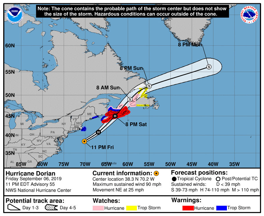
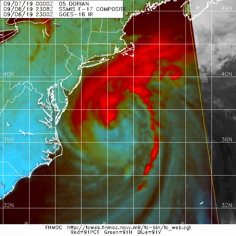
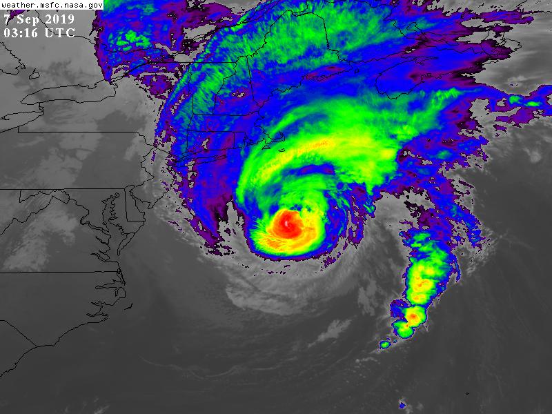
025628_5day_cone_with_line.png
20190906.2308.f17.91pct91h91v.05L.DORIAN.80kts.958mb.37.5N.71.2W.090pc.jpg
GOES03162019250B7s72W.jpg
回復

使用道具 舉報

簽到天數: 588 天

[LV.9]以壇為家II

Meow|2019-9-6 11:07 | 顯示全部樓層
值得紀念
90.jpeg

點評

可能前期歐洲模式認為會穿越墨西哥灣,也許川大看了模式預測,之後颶風卻飄向北方.............  發表於 2019-9-6 22:11
NET
我不太了解時事哽,大總統又做了啥事?  發表於 2019-9-6 19:21
回復

使用道具 舉報

12345下一頁
快速回覆
您需要登錄後才可以回帖 登錄 | 立即加入

本版積分規則

本平台僅供學術討論之用,預報應以氣象局為準

威普網站虛擬主機贊助公司

臺灣第一個天氣類型社群平台 即時天氣資訊、精準颱風動態

線上客服
FB傳送訊息
廣告行銷
精準行銷 物超所值
官方粉專
發佈 快速回復 返回頂部 返回列表