開啟輔助訪問
 找回密碼
 立即加入

05L.Dorian 年度風王 巔峰強襲巴哈馬群島

簽到天數: 3279 天

[LV.Master]伴壇終老

t02436|2019-9-6 10:09 | 顯示全部樓層
昨天00Z一度重回C3,今天00Z已減弱為90節,中心即將通過北卡。
05L DORIAN 190906 0000 33.4N 77.9W ATL 90 958
05L DORIAN 190905 1800 32.7N 78.9W ATL 95 958
05L DORIAN 190905 1200 32.1N 79.2W ATL 100 959
05L DORIAN 190905 0600 31.4N 79.6W ATL 100 957
05L DORIAN 190905 0000 30.7N 79.7W ATL 100 958
05L DORIAN 190904 1800 30.1N 79.7W ATL 90 964
05L DORIAN 190904 1200 29.5N 79.6W ATL 90 964
05L DORIAN 190904 0600 28.8N 79.2W ATL 95 964
05L DORIAN 190904 0000 28.1N 78.8W ATL 95 959
05L DORIAN 190903 1800 27.5N 78.7W ATL 95 959
05L DORIAN 190903 1200 27.1N 78.4W ATL 100 954
931
WTNT45 KNHC 052051
TCDAT5

Hurricane Dorian Discussion Number  50
NWS National Hurricane Center Miami FL       AL052019
500 PM EDT Thu Sep 05 2019

During the last 12 h, Dorian appears to have started the expected
slow weakening trend.  Air Force Reserve Hurricane Hunter data show
that the central pressure inside the 35-45 n mi wide eye is slowly
rising, and satellite imagery indicates that the eye is becoming
less well defined.  The current Hurricane Hunter aircraft has
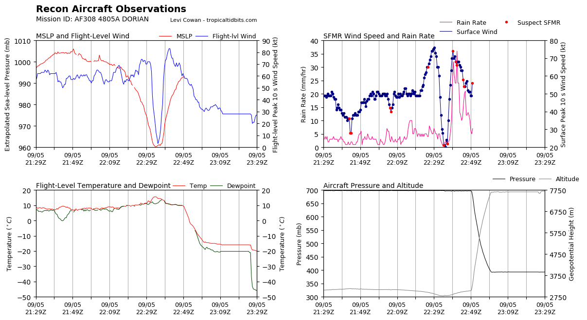
reported maximum SFMR surface wind estimates of 88 kt, along with
700 mb flight-level winds of 91 kt. Based on these data, the initial
intensity is reduced to 90 kt.

The hurricane is continuing its expected northeastward turn, and the
initial motion is now 035/9.  The mid-latitude westerlies should
steer Dorian generally northeastward at an increasing forward speed,
with the eye passing near of over portions of the North Carolina
coast during the next 12-24 h.  After that, Dorian is forecast to
move quickly across the northwest Atlantic and be near or over the
Canadian Maritimes/Atlantic provinces by 60 h.  As was the case in
the previous advisory, the track guidance remains tightly clustered,
and the new forecast track is changed little from the previous
one.

Due to increasing shear, Dorian is forecast to slowly weaken as it
moves near and along the South and North Carolina coasts.
Extratropical transition should begin around 36-48 h and be complete
by 60 h, although Dorian is forecast to maintain hurricane-force
winds through the transition.  After transition is complete, the
extratropical low should weaken over the far north Atlantic and be
absorbed into a larger low pressure area by 120 h.

The center of Dorian is expected to move very near or over the
coastline of the Carolinas and the southern Mid-Atlantic states.
Residents of these areas should already be prepared for damaging
winds, life-threatening storm surges, and flooding rains.  It also
appears that Dorian will affect portion of eastern Canada as a
hurricane-force extratropical low.

Key Messages:

1. Life-threatening storm surge and dangerous winds are expected
along portions the coasts of South Carolina and North Carolina, and
portions of southeast Virginia and the southern Chesapeake Bay,
regardless of the exact track of Dorian's center.  Water levels
could rise well in advance of the arrival of strong winds. Residents
in these areas should follow advice given by local emergency
officials.

2. Flash flooding is occurring, and will continue to become more
widespread across the eastern Carolinas and far southeast Virginia
through tonight. There is a high risk of flash flooding over these
areas, where significant, life-threatening, flash flooding is
expected.

FORECAST POSITIONS AND MAX WINDS

INIT  05/2100Z 33.1N  78.5W   90 KT 105 MPH
12H  06/0600Z 34.2N  77.2W   90 KT 105 MPH
24H  06/1800Z 36.0N  74.4W   85 KT 100 MPH
36H  07/0600Z 38.5N  70.4W   80 KT  90 MPH
48H  07/1800Z 42.0N  65.9W   75 KT  85 MPH
72H  08/1800Z 50.0N  57.5W   65 KT  75 MPH...POST-TROP/EXTRATROP
96H  09/1800Z 56.0N  45.5W   50 KT  60 MPH...POST-TROP/EXTRATROP
120H  10/1800Z...DISSIPATED

$$
Forecaster Beven
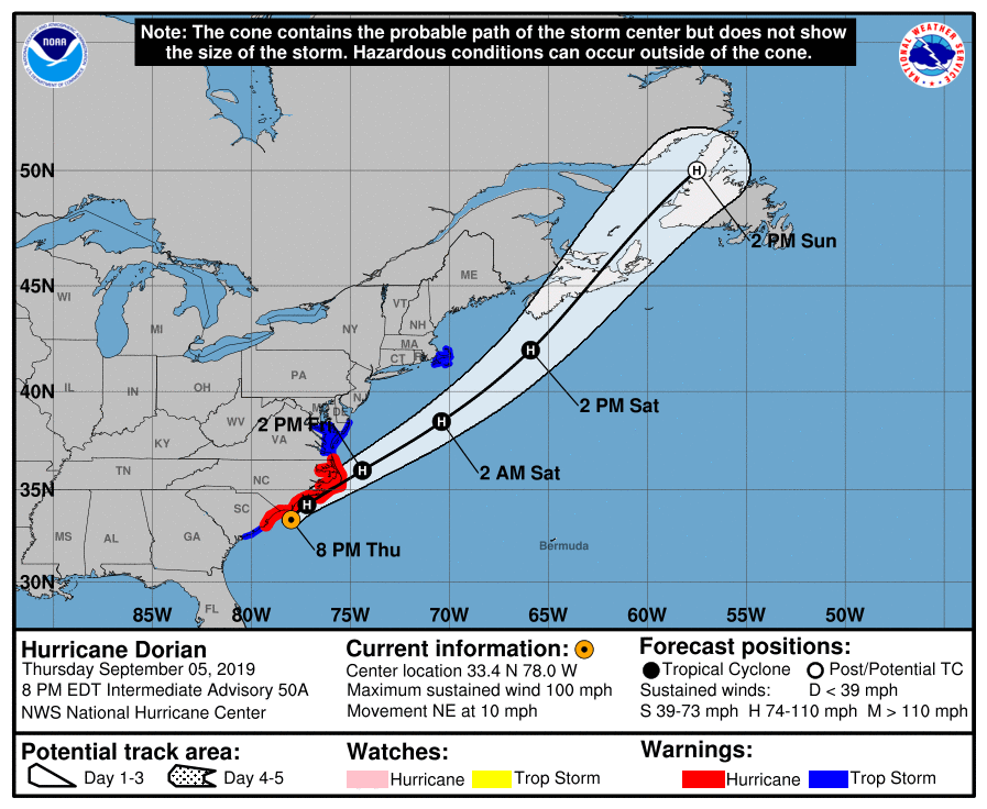
211226_3day_cone_with_line.png

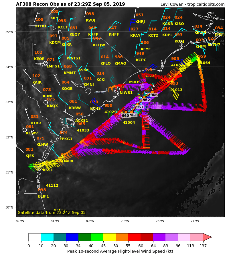
recon_AF308-4805A-DORIAN.png

recon_AF308-4805A-DORIAN_timeseries.png

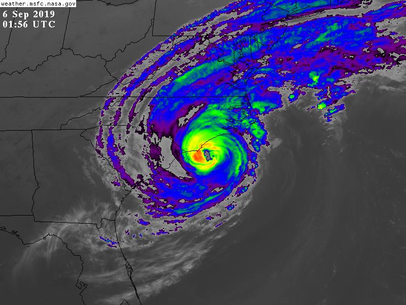
GOES01562019249HqxQof.jpg
回復

使用道具 舉報

簽到天數: 601 天

[LV.9]以壇為家II

霧峰追風者|2019-9-5 23:13 | 顯示全部樓層
(中央社巴哈馬首都拿索4日綜合外電報導)颶風多利安(Dorian)肆虐巴哈馬造成嚴重災情,死亡人數目前攀升至20人,美國海岸防衛隊與英國皇家海軍協助救援,今天以直升機救出倖存者並運送緊急救援物資。

法新社報導,聯合國表示,大巴哈馬島(Grand Bahama)與阿巴科島(Abaco island)上有7萬人現在「急需」救援,待援人數幾乎就是兩處總人口數。同時,巴哈馬政府證實罹難人數增至20人,預料還會進一步攀升。

Embed from Getty Images
gettyimages-1172291691-2048x2048.jpg
▲颶風多利安在巴哈馬群島停留一天以上後,有社區被夷為平地,還有機場與醫院被水淹沒。

巴哈馬與美國媒體報導,巴哈馬衛生部長桑茲(Duane Sands)說:「我們現在開始對罹難人數有更清楚的了解,至少是對阿巴科島與大巴哈馬島的災情來說。」

他說:「目前,阿巴科與大巴哈馬島的罹難人數攀升至20人。但請大家記得,前進淹水區、搜索民宅的搜救行動現在才要開始。」

聯合國緊急救援協調員洛科克(Mark Lowcock)在與巴哈馬總理米尼斯(Hubert Minnis)開完會後表示,大巴哈馬島上的5萬人與阿巴科島上的1.5萬到2萬人,現在急需棲身之所、安全飲用水、糧食與藥物。

Embed from Getty Images

▲颶風多利安肆虐巴哈馬造成嚴重災情,死亡人數目前攀升至20人,大規模救援正在進行中。

巴哈馬群島最北端的大巴哈馬島與阿巴科島在遭史上威力數一數二的大西洋颶風重創後,紅十字會幹部麥克安德魯(Stephen McAndrew)表示,救援行動「最重要的就是速度」。

美國海岸防衛隊與英國皇家海軍的直升機協助醫療救援、進行空中評估協調救援行動,並展開偵察飛行來評估災情。

路透社報導,巴哈馬總理米尼斯在記者會上說:「我們遭遇史上最嚴重的全國危機之一,預料死亡人數將攀升,這只是初步資訊。」

大巴哈馬島千禧大教堂(Jubilee Cathedral)牧師威廉斯(LaQuez Williams)開放教堂作為約150名災民的避難處。他說,他看到有災民爬到屋頂求援。

威廉斯說:「有人求救卻救不到他們。情況真的很艱困,讓人覺得很無助。」

美國有線電視新聞網(CNN)報導,空拍畫面顯示,阿巴科島綿延數公里的街區嚴重淹水,翻覆的船隻與貨櫃像玩具般散落各處,許多建築牆壁倒塌、屋頂被掀飛。


回復

使用道具 舉報

簽到天數: 582 天

[LV.9]以壇為家II

蜜露|2019-9-5 01:43 | 顯示全部樓層
本帖最後由 蜜露 於 2019-9-8 02:18 編輯

Hurricane-Dorian-03.jpg

0903-ctm-dorianbahamas-begnaud-1925436-640x360.jpg

bandicam 2019-09-02 20-24-43-367.jpg

bandicam 2019-09-02 20-11-23-140.jpg

4431c0c0-58e1-4356-b0f8-348358c3cba5-EPA_BAHAMAS_HURRICANE_DORIAN.jpg


dorian-bahamas-aerial-4-rt-ps-190904_hpMain_2_31x13_992.jpg

p07mcyx7.jpg

h1-dorian-hurricane-bahamas-destruction-deaths-climate-change.jpg
hurricane-dorian-bahamas-death-toll.jpg

多里安颶風在巴哈馬群島(大巴哈馬島、大阿巴科島) 橫掃一片,尤其是移速很慢每小時只有10公里上下


風暴潮有7米高,多數地方都有淹水。

273967f357594b9b8dbfb469e3d7146c_18.jpg

不過多里安颶風雖然初報是160Kts、911hPa (比艾瑪颶風的914hPa還低)


直播多數參考價值


但是更大的空拍證據,多里安颶風的風毀程度整體而言其實比不過艾瑪颶風的摧毀威力


還記得艾瑪颶風真的很猛,很多當地都有直播(至今直播應該還有留下的(直播感受是海燕颱風之後,第二就是艾瑪颶風))


而且多里安的FL也不高  不過也才161Kts


FL
2015 帕翠莎     192kts 東太
2010 梅姬       190kts 西太
1988 吉爾伯特   173kts 北大
2017 艾瑪       171kts 北大
2005 威爾瑪     168kts 北大
2007 狄安       164kts 北大
2008 薔蜜       163kts 西太
2019 多里安     161kts 北大
2017 瑪莉亞     159kts 北大


回復

使用道具 舉報

簽到天數: 588 天

[LV.9]以壇為家II

Meow|2019-9-4 13:29 | 顯示全部樓層
本帖最後由 Meow 於 2019-9-4 13:37 編輯

Josh Morgerman:

Yep, I’m alive. Made it to Nassau. #Hurricane #DORIAN: By far the most intense cyclone I’ve witnessed in 28 years of chasing. Thought I was playing it safe by riding it out in a solid-concrete school on a hill in Marsh Harbour. Thought wrong.

Winds pounded the building with the force of a thousand sledgehammers. Crept out during eye to find school mostly destroyed, cars in parking lot thrown around & mutilated. Barometer said 913.4 mb.

Frantically piled into few functioning cars (one of them mine) & relocated to government complex before backside struck. Building filled with terrorized refugees, many who had  swam to safety or abandoned collapsed houses. The calm eye saved lives—gave victims chance to relocate.

Whole neighborhoods were swept by mighty surge higher than anything in memory. Areas above water had catastrophic wind damage. Many deaths reported from drowning, flying debris, & collapsing houses. Medical clinic overwhelmed. An absolute catastrophe. SEND HELP TO ABACO ISLANDS.

iCyclone_2019-Sep-04.jpg
回復

使用道具 舉報

簽到天數: 601 天

[LV.9]以壇為家II

霧峰追風者|2019-9-3 08:51 | 顯示全部樓層
巔峰已過,逐漸北上,對佛州威脅已大幅降低。
426
WTNT45 KNHC 022046
TCDAT5

Hurricane Dorian Discussion Number  38
NWS National Hurricane Center Miami FL       AL052019
500 PM EDT Mon Sep 02 2019

Dorian remains an impressive hurricane in satellite imagery.
Recent radar and aircraft observations are again showing signs of
a concentric eyewall structure which might be one of the factors
that has led to a decrease in the peak winds and a small expansion
of the wind field.  An Air Force Reserve Hurricane Hunter aircraft
reported peak flight-level winds of 129 kt, SFMR winds of 121
kt, and a central pressure that has risen to 940 mb. Based on these
observations, the initial wind speed has been set at 125 kt.  Some
additional decrease in wind speed is likely in the short term due
due to a possible eyewall replacement and upwelling of cooler
waters caused by the very slow motion of the hurricane. Although
some additional slow weakening is forecast while the hurricane moves
northward along the southeastern United States coastline due to
increasing southwesterly shear, Dorian is forecast to remain a
powerful hurricane during that time.  The NHC intensity forecast
forecast is a blend of the latest statistical and and consensus
model guidance.

Dorian has become nearly stationary this afternoon with the two most
recent aircraft fixes showing essentially no motion.  A slow
westward to west-northwestward motion should resume overnight and
continue into early Tuesday, with the eye and devastating winds only
slowly pulling away from Grand Bahama Island.  By Tuesday afternoon,
Dorian should begin its much anticipated northwestward turn as a
weakness becomes more pronounced in the subtropical ridge.  Although
the center of Dorian is forecast to move near, but parallel to, the
Florida east coast, only a small deviation of the track toward the
west would bring the core of the hurricane onshore.  A broad mid-
latitude trough should help turn Dorian northeastward by Wednesday
night, and the track models show the center coming precariously
close to the southeastern United States coast.  The tracks from the
1200 UTC runs of the global models have remained fairly stable,
which has resulted in little overall change to the latest NHC track
forecast.

Users are reminded that the hurricane is not a point, and that
life-threatening storm surge and hurricane-force winds extend far
from the center. Regardless of the exact forecast track, strong
winds and a life-threatening storm surge are likely along a portion
of the U.S east coast from Florida through the Carolinas.

Key Messages:

1. Devastating winds and storm surge will continue to affect Grand
Bahama Island through tonight. Everyone there should remain in
shelter and not venture into the eye.

2. Life-threatening storm surge and dangerous hurricane-force winds
are expected along portions of the Florida east coast and the coasts
of Georgia and South Carolina, regardless of the exact track of
Dorian's center. Water levels could begin to rise well in advance of
the arrival of strong winds. Residents in these areas should follow
advice given by local emergency officials.

3. The risk of life-threatening storm surge and hurricane-force
winds continues to increase along the coast North Carolina.
Residents in these areas should follow advice given by local
emergency officials.

4. Heavy rains, capable of producing life-threatening flash floods,
are expected over northern portions of the Bahamas and coastal
sections of the southeast and lower mid-Atlantic regions of the
United States through Friday.

FORECAST POSITIONS AND MAX WINDS

INIT  02/2100Z 26.8N  78.4W  125 KT 145 MPH
12H  03/0600Z 27.0N  78.7W  115 KT 130 MPH
24H  03/1800Z 27.6N  79.1W  110 KT 125 MPH
36H  04/0600Z 28.7N  79.7W  110 KT 125 MPH
48H  04/1800Z 30.0N  80.1W  105 KT 120 MPH
72H  05/1800Z 32.8N  78.6W   95 KT 110 MPH
96H  06/1800Z 36.6N  73.1W   80 KT  90 MPH
120H  07/1800Z 43.5N  64.0W   75 KT  85 MPH...POST-TROP/EXTRATROP

$$
Forecaster Brown
215101.png

點評

就這樣一直賴在巴哈馬不走?  發表於 2019-9-3 17:20
回復

使用道具 舉報

簽到天數: 582 天

[LV.9]以壇為家II

蜜露|2019-9-2 19:41 | 顯示全部樓層
本帖最後由 蜜露 於 2019-9-2 20:22 編輯


剛研究了一下其實我發現,這SFMR有問題的


他的投落儀兩次都分別是160Kts、177kts


這其實是陣風


005502qp37sgspp7vysgsx.png


cbmtxuj.png


177kts換算一分鐘正是155kts


20190901.180000.aqua.modis.Vapor.tc1905LDORIAN.covg92p5.modislance.res1km.jpg


機構給予 : 911hPa  160kts
巔峰推測 : 907.8hPa
投落儀  : 177kts(陣風)  換算一分鐘 155kts

風速實測跟艾瑪差不多,我覺得比2017颶風艾瑪稍差一點點,艾瑪真的霸氣多了。


點評

艾瑪和多利安都是屬於緊實型但沒啥外圍環流的颶風,這種型態的颶風北大西洋較常看到  發表於 2019-9-7 18:28
恩 房屋風毀程度就比不過Irma了  發表於 2019-9-5 01:20
645
底層方面IRMA感覺還是強一點 前天看直播感覺風沒有IRMA來的有魄力  發表於 2019-9-3 06:26
645
IRMA的FL有170+吧 多利安最高一次才161  發表於 2019-9-3 06:24
回復

使用道具 舉報

簽到天數: 1826 天

[LV.Master]伴壇終老

typhoonman|2019-9-2 13:54 來自手機 | 顯示全部樓層
老農民版夜神月 發表於 2019-8-25 09:09
NHC24/21Z升格TS,命名Dorian,巔峰暫時上望颶風75節

https://youtu.be/6coyXpORKRM
來分享一下颶風獵人飛進Dorian颶風眼內的影片吧!

評分

參與人數 1水氣能量 +1 收起 理由
nshwai + 1 贊一個!

查看全部評分

回復

使用道具 舉報

簽到天數: 3279 天

[LV.Master]伴壇終老

t02436|2019-9-2 06:09 | 顯示全部樓層
評價160節 911百帕正報
000
WTNT45 KNHC 012056
TCDAT5

Hurricane Dorian Discussion Number  34
NWS National Hurricane Center Miami FL       AL052019
500 PM EDT Sun Sep 01 2019

The distinct eye of powerful Hurricane Dorian is moving over
Great Abaco.  The latest wind and pressure data from an Air Force
reconnaissance plane just before the eye hit the island indicated
that the winds reached 160 kt, which is the initial intensity for
this advisory. It is not very often that we measure such strong
winds. The minimum pressure measured by the plane was 910 mb.

The eye has been shrinking, and an eyewall replacement cycle is
possibly occurring.  The effect of the island terrain and the
eyewall replacement cycle should result in some slight fluctuations
in intensity during the next 24 to 36 hours, but the hurricane will
continue to be extremely dangerous one during that time. After 3
days, a more definite weakening trend should begin as the hurricane
encounters stronger shear. Dorian however, it is forecast to remain
a hurricane for the next 5 days.

Dorian has slowed down even more and is now moving toward the west
or 270 degrees at 4 kt. The steering currents are collapsing and
Dorian is expected to slow down a little more, prolonging its
catastrophic effects in the northwestern Bahamas. The NHC forecast
calls for a slow west to west-northwest motion during the next 48
hours. A turn to the north and northeast with a gradual increase in
forward speed is expected thereafter, as the mid-level trough over
the eastern United States deepens.  The current forecast is not very
different from the previous one, and it is very close to the
multi-model consensus TVCA. Both the deterministic and consensus
tracks have shown the usual variability to the right or to the left
from run to run, but the overall trend is for the hurricane to turn
northward offshore but dangerously close to the Florida peninsula.

Given the uncertainty in the track forecast and the anticipated
increase in size of the hurricane, a Hurricane Warning and Storm
Surge Warning have been issued for a portion of the Florida east
coast. It is once again emphasized that although the official track
forecast does not show landfall, users should not focus on the exact
track. A small deviation to the left of the track could bring the
intense core of the hurricane its dangerous winds closer to or onto
the Florida coast.

Key Messages:

1. A prolonged period of catastrophic winds and storm surge will
affect the Abaco Islands and Grand Bahama Island tonight. Everyone
there should take immediate shelter and not venture into the eye.

2. Life-threatening storm surge and dangerous hurricane-force winds
are expected along portions of the Florida east coast through
mid-week, and storm surge and hurricane warnings are in effect. Only
a slight deviation to the left of the official forecast would bring
the core of Dorian near or over the Florida east coast. Residents
should listen to advice given by local emergency officials.

3. There is an increasing likelihood of strong winds and dangerous
storm surge along the coasts of Georgia, South Carolina, North
Carolina later this week. Residents in these areas should continue
to monitor the progress of Dorian and listen to advice given by
local emergency officials.

4. Heavy rains, capable of producing life-threatening flash floods,
are expected over northern portions of the Bahamas and coastal
sections of the southeast and lower mid-Atlantic regions of the
United States through late this week.

FORECAST POSITIONS AND MAX WINDS

INIT  01/2100Z 26.6N  77.3W  160 KT 185 MPH
12H  02/0600Z 26.7N  78.1W  155 KT 180 MPH
24H  02/1800Z 26.8N  78.7W  145 KT 165 MPH
36H  03/0600Z 27.0N  79.0W  135 KT 155 MPH
48H  03/1800Z 27.7N  79.5W  125 KT 145 MPH
72H  04/1800Z 30.0N  80.3W  105 KT 120 MPH
96H  05/1800Z 33.0N  78.5W   90 KT 105 MPH
120H  06/1800Z 36.5N  73.5W   80 KT  90 MPH

$$
Forecaster Avila

220614_5day_cone_with_line.png

GOES22012019244eiehaK.jpg

點評

這路徑美國沿海應該會很慘烈吧!  發表於 2019-9-3 08:40
實測無敵~實測萬歲~  發表於 2019-9-2 09:05
回復

使用道具 舉報

快速回覆
您需要登錄後才可以回帖 登錄 | 立即加入

本版積分規則

本平台僅供學術討論之用,預報應以氣象局為準

威普網站虛擬主機贊助公司

臺灣第一個天氣類型社群平台 即時天氣資訊、精準颱風動態

線上客服
FB傳送訊息
廣告行銷
精準行銷 物超所值
官方粉專
發佈 快速回復 返回頂部 返回列表