開啟輔助訪問
 找回密碼
 立即加入

05L.Dorian 年度風王 巔峰強襲巴哈馬群島

簽到天數: 3279 天

[LV.Master]伴壇終老

t02436|2019-9-2 00:53 | 顯示全部樓層
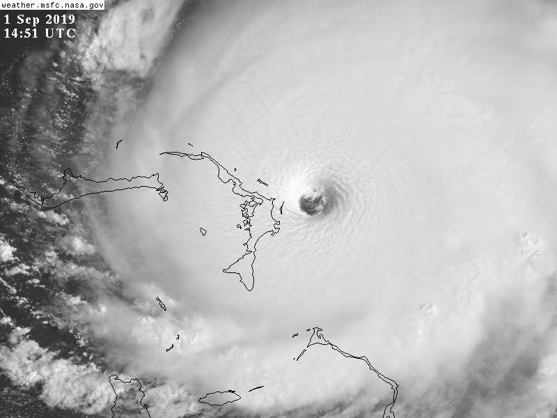
1645Z加報更新,中心已於1640Z登陸
巴哈馬大阿巴科島已進入風眼中心
160KT 911hPa
763
WTNT65 KNHC 011644
TCUAT5

Hurricane Dorian Tropical Cyclone Update
NWS National Hurricane Center Miami FL       AL052019
1245 pm EDT Sun Sep 01 2019

...CATASTROPHIC CATEGORY 5 DORIAN MAKES LANDFALL ON ELBOW CAY IN THE
ABACOS...


Data from an Air Force Reserve Hurricane Hunter aircraft and
satellite data indicate that Dorian has made landfall at 1240 pm
EDT (1640 UTC) in Elbow Cay, Abacos.
The winds have increased
to 185 mph (295 km/h) with the minimum central pressure falling to
911 mb (26.90 inches).


This is a life-threatening situation.  Residents there should take
immediate shelter.  Do not venture into the eye if it passes over
your location.

Hazards:
- Wind Gusts over 220 mph
- Storm Surge 18 to 23 feet above normal tide levels with higher
destructive waves

These hazards will cause extreme destruction in the affected areas
and will continue for several hours.


SUMMARY OF 1245 PM EDT...1645 UTC...INFORMATION
----------------------------------------------
LOCATION...26.5N 77.0W
ABOUT 5 MI...10 KM E OF GREAT ABACO ISLAND
MAXIMUM SUSTAINED WINDS...185 MPH...295 KM/H
PRESENT MOVEMENT...W OR 275 DEGREES AT 8 MPH...13 KM/H
MINIMUM CENTRAL PRESSURE...911 MB...26.90 INCHES

$$
Forecaster Avila/Blake

GOES16462019244g5hQqB.jpg

recon_AF302-2805A-DORIAN.png

recon_AF302-2805A-DORIAN_timeseries.png

goes16_truecolor_05L_201909011647.jpg

GOES16512019244coSVlS.jpg
584
URNT12 KNHC 011648
VORTEX DATA MESSAGE   AL052019
A. 01/16:23:30Z
B. 26.50 deg N 076.93 deg W
C. 700 mb 2324 m
D. 913 mb
E. 280 deg 18 kt
F. CLOSED
G. C13
H. 171 kt
I. 131 deg 6 nm 16:21:30Z
J. 229 deg 154 kt
K. 131 deg 7 nm 16:21:00Z
L. 177 kt
M. 341 deg 9 nm 16:27:00Z
N. 073 deg 161 kt
O. 343 deg 10 nm 16:27:30Z
P. 8 C / 3057 m
Q. 24 C / 3044 m
R. 4 C / NA
S. 12345 / 7
T. 0.02 / 1 nm
U. AF302 2805A DORIAN OB 30
MAX FL WIND 161 KT 343 / 10 NM 16:27:30Z
;
回復

使用道具 舉報

簽到天數: 1989 天

[LV.Master]伴壇終老

ben811018|2019-9-1 23:29 | 顯示全部樓層

擷取.PNG 2.png
存圖啦
(好難得...)

點評

美麗又令人戰慄的龍捲  發表於 2019-9-2 11:09
回復

使用道具 舉報

簽到天數: 3279 天

[LV.Master]伴壇終老

t02436|2019-9-1 23:01 | 顯示全部樓層
15Z維持155節評價,天佑巴哈馬...
913hPa 155KT
SUMMARY OF 1100 AM EDT...1500 UTC...INFORMATION
-----------------------------------------------
LOCATION...26.5N 76.8W
ABOUT 20 MI...30 KM ENE OF GREAT ABACO ISLAND
ABOUT 205 MI...330 KM E OF WEST PALM BEACH FLORIDA
MAXIMUM SUSTAINED WINDS...180 MPH...285 KM/H
PRESENT MOVEMENT...W OR 270 DEGREES AT 7 MPH...11 KM/H
MINIMUM CENTRAL PRESSURE...913 MB...26.96 INCHES
ZCZC MIATCDAT5 ALL
TTAA00 KNHC DDHHMM

Hurricane Dorian Discussion Number  33
NWS National Hurricane Center Miami FL       AL052019
1100 AM EDT Sun Sep 01 2019

Air Force and NOAA reconnaissance planes penetrated the distinct
eye of Dorian, and found that the hurricane has become extremely
intense with a stadium effect in the eye. The NOAA plane reported a
peak flight-level wind of 159 kt, while the SFMR from both planes
have measured winds between 155 and 170 kt.
  A dropsonde from the
NOAA plane measured a wind gust of 176 kt at the surface.
A blend of
these measurements yield to an initial intensity of 155 kt, making
Dorian the strongest hurricane on record in the northwestern
Bahamas.


For the next few days, Dorian should experience some fluctuations in
intensity, and in addition to eyewall replacement cyclone, the
interaction with the northwestern Bahamas should weaken the
hurricane slightly. After 3 days, as Dorian moves northward along
or offshore of southeast United States coast, the shear is forecast
to increase, resulting in a more distinct gradual weakening.

Reconnaissance plane and satellite fixes indicate that Dorian, as
anticipated, has slowed down and is moving toward the west or 270
degrees at 6 kt. The steering currents are collapsing and Dorian is
expected to slow down even more, prolonging its catastrophic effects
in the northwestern Bahamas. The NHC forecast calls for a slow west
to west-northwest motion during the next 48 hours, with a turn to
the north and an increase in forward speed as the mid-level trough
along the eastern United States deepens and becomes the dominant
steering feature. The current forecast is only a few miles west of
the previous one and is basically on top of the multi-model
consensus. Both the deterministic and consensus tracks have shown
the usual variability to the right or to the left from run to run,
but the overall trend is for the hurricane to turn northward
offshore but very close to the Florida peninsula.

Given the uncertainty in the track forecast and the anticipated
increase in size of the hurricane, a Hurricane Watch and Storm
Surge Watch have been issued for a portion of the east Florida
coast. It is emphasized that although the official track forecast
does not show landfall, users should not focus on the exact track. A
small deviation to the left of the track could bring the intense
core of the hurricane its dangerous winds closer to or onto the
coast.

Key Messages:

1. A prolonged period of catastrophic winds and storm surge will
affect the Abaco Islands today. Everyone there should take immediate
shelter and not venture into the eye. These catastrophic conditions
are likely on Grand Bahama Island later today or tonight, and
efforts to protect life and property there should be rushed to
completion.

2. Storm surge and hurricane watches and tropical storm warnings are
in effect for portions of the Florida east coast. Life-threatening
storm surge and dangerous hurricane-force winds are possible along
portions of the Florida east coast through mid-week, as only a
slight deviation to the left of the official forecast would bring
the core of Dorian near or over the coast. Residents should listen
to advice given by local emergency officials.

3. There is an increasing likelihood of strong winds and dangerous
storm surge along the coasts of Georgia, South Carolina, and North
Carolina later this week. Residents in these areas should continue
to monitor the progress of Dorian.

4. Heavy rains, capable of producing life-threatening flash floods,
are possible over northern portions of the Bahamas and coastal
sections of the southeast and lower mid-Atlantic regions of the
United States through late this week.

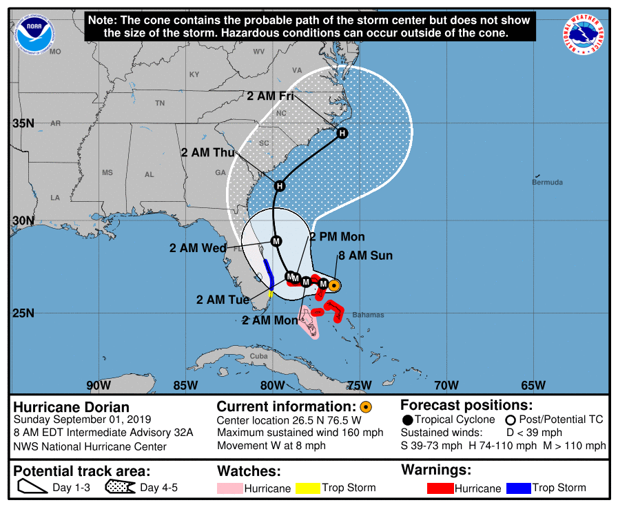
FORECAST POSITIONS AND MAX WINDS

INIT  01/1500Z 26.5N  76.8W  155 KT 180 MPH
12H  02/0000Z 26.6N  77.7W  150 KT 175 MPH
24H  02/1200Z 26.8N  78.5W  145 KT 165 MPH
36H  03/0000Z 27.0N  79.0W  135 KT 155 MPH
48H  03/1200Z 27.4N  79.4W  120 KT 140 MPH
72H  04/1200Z 29.7N  80.2W  100 KT 115 MPH
96H  05/1200Z 32.5N  79.0W   85 KT 100 MPH
120H  06/1200Z 35.5N  74.5W   80 KT  90 MPH

$$
Forecaster Avila

NNNN
115245_5day_cone_with_line.png

GOES14512019244nUC7J3.jpg

點評

155kt等同於2015的蘇迪勒.......,這兩三年的大西洋風暴簡直都吃藥了  發表於 2019-9-1 23:30
回復

使用道具 舉報

簽到天數: 3279 天

[LV.Master]伴壇終老

t02436|2019-9-1 22:53 | 顯示全部樓層
NHC根據實測加報調升強度到155節!
000
WTNT65 KNHC 011330
TCUAT5

Hurricane Dorian Tropical Cyclone Update
NWS National Hurricane Center Miami FL       AL052019
930 AM EDT Sun Sep 01 2019

...CATASTROPHIC CATEGORY 5 DORIAN CONTINUING TO INTENSIFY AS IT
APPROACHES THE ABACO ISLANDS...

Data from an Air Force Reserve Hurricane Hunter aircraft indicate
that Dorian has continued to intensify, and now has maximum
sustained winds near 175 mph (280 km/h), with a minimum central
pressure of 922 mb (27.23 inches).

The eyewall of catastrophic Hurricane Dorian is currently reaching
the Abaco Islands.  This is a life-threatening situation.  Residents
there should take immediate shelter.  Do not venture into the eye if
it passes over your location.

Hazards:
- Wind Gusts over 200 mph
- Storm Surge 15 to 20 feet above normal tide levels with higher
destructive waves

These hazards will cause extreme destruction in the affected areas.
and will continue for several hours.


SUMMARY OF 930 AM EDT...1330 UTC...INFORMATION
----------------------------------------------
LOCATION...26.5N 76.6W
ABOUT 25 MI...40 KM ENE OF GREAT ABACO ISLAND
ABOUT 210 MI...340 KM E OF WEST PALM BEACH FLORIDA
MAXIMUM SUSTAINED WINDS...175 MPH...280 KM/H
PRESENT MOVEMENT...W OR 275 DEGREES AT 8 MPH...13 KM/H
MINIMUM CENTRAL PRESSURE...922 MB...27.73 INCHES

$$
Forecaster Brennan/Blake/Zelinsky/Avila

20190901.1410.goes-16.ir.05L.DORIAN.140kts.927mb.26.5N.76.5W.100pc.jpg

NOAA2實測持續測得大於160節的風速
recon_NOAA2-2905A-DORIAN.png

recon_NOAA2-2905A-DORIAN_timeseries.png
回復

使用道具 舉報

簽到天數: 582 天

[LV.9]以壇為家II

蜜露|2019-9-1 22:10 | 顯示全部樓層
本帖最後由 蜜露 於 2019-9-1 22:37 編輯


AF302飛機 投落儀達到了 160Kts !!!!


颶風多利安升到Cat.5  而且還有繼續增強的趨勢 ,  兩架飛機同時觀測,其中一架AF302 投落儀達到了 160Kts !!!!


recon_AF302-2805A-DORIAN_timeseries (1).png


recon_AF302-2805A-DORIAN_dropsonde10_20190901-1320.png


NHC颶風中心有提到SFMR好像有點詭異 ,但是投落儀達到了160Kts 可靠性很大


bandicam 2019-09-01 22-09-31-191.jpg


有可能掃過巴哈馬幾個島,最後從美國東部沿岸北上。


2019AL05_4KMSRBDC_201909011400.jpg

回復

使用道具 舉報

簽到天數: 3279 天

[LV.Master]伴壇終老

t02436|2019-9-1 21:12 | 顯示全部樓層
NHC12Z評價140節,北大西洋連續4年有C5達標
...EYEWALL OF NOW CATASTROPHIC CATEGORY 5 HURRICANE DORIAN ABOUT TO
HIT THE ABACO ISLANDS WITH DEVASTATING WINDS...
...LIFE-THREATENING STORM SURGE AND VERY HEAVY RAINFALL ALSO
EXPECTED...


SUMMARY OF 800 AM EDT...1200 UTC...INFORMATION
----------------------------------------------
LOCATION...26.5N 76.5W
ABOUT 35 MI...55 KM E OF GREAT ABACO ISLAND
ABOUT 225 MI...360 KM E OF WEST PALM BEACH FLORIDA
MAXIMUM SUSTAINED WINDS...160 MPH...260 KM/H
PRESENT MOVEMENT...W OR 275 DEGREES AT 8 MPH...13 KM/H
MINIMUM CENTRAL PRESSURE...927 MB...27.37 INCHES

115245_5day_cone_with_line.png

recon_AF302-2805A-DORIAN_timeseries.png

recon_AF302-2805A-DORIAN.png

GOES130620192441JN3oR.jpg
回復

使用道具 舉報

簽到天數: 582 天

[LV.9]以壇為家II

蜜露|2019-9-1 10:45 | 顯示全部樓層
本帖最後由 蜜露 於 2019-9-1 10:57 編輯


颶風獵人兩架飛機飛過了颶風中心

AF308 NOAA2
多莉安最近這兩個小時實測非常驚人


recon_NOAA2-2605A-DORIAN_timeseries.png


recon_AF308-2505A-DORIAN_timeseries.png

recon_AF308-2505A-DORIAN.png

最高一度還達到150kts耶 940hPa上下

bandicam 2019-09-01 10-46-11-224.jpg

巴哈馬的雷達顯示的颶風底層
最新有可能從美國佛州以東北上


回復

使用道具 舉報

簽到天數: 3279 天

[LV.Master]伴壇終老

t02436|2019-8-31 23:03 | 顯示全部樓層
飛機實測資料存檔
516
URNT12 KNHC 311349
VORTEX DATA MESSAGE   AL052019
A. 31/13:27:10Z
B. 25.88 deg N 073.17 deg W
C. 700 mb 2622 m
D. 945 mb
E. 085 deg 8 kt
F. CLOSED
G. C14
H. 141 kt
I. 042 deg 10 nm 13:24:00Z
J. 125 deg 131 kt
K. 042 deg 10 nm 13:24:00Z
L. 117 kt
M. 227 deg 6 nm 13:29:00Z
N. 312 deg 108 kt
O. 227 deg 6 nm 13:29:00Z
P. 8 C / 3086 m
Q. 19 C / 3044 m
R. NA / NA
S. 12345 / 7
T. 0.02 / 1 nm
U. AF302 2305A DORIAN OB 11
MAX FL WIND 131 KT 042 / 10 NM 13:24:00Z
;

recon_NOAA2-2205A-DORIAN_timeseries.png
recon_NOAA2-2205A-DORIAN.png
recon_AF302-2305A-DORIAN_timeseries.png
recon_AF302-2305A-DORIAN.png

NHC 15Z報再根據實測調升評價至130節,上望135。
000
WTNT45 KNHC 311456
TCDAT5

Hurricane Dorian Discussion Number  29
NWS National Hurricane Center Miami FL       AL052019
1100 AM EDT Sat Aug 31 2019

Dorian's satellite presentation is outstanding with a distinct eye
of about 15 n mi in diameter. Both NOAA and Air Force Hurricane
Hunter planes have been penetrating the eye this morning and based
on a blend of the flight-level and SFMR winds, the initial intensity
has been adjusted upward to 130 kt in this advisory. Dorian is
forecast to move over a deep layer of very warm waters, which is
like high octane-fuel for hurricanes. The combination of the warm
ocean and the prevailing low shear along Dorian's path should favor
some additional strengthening, but most likely the hurricane will
experience some fluctuations in intensity due to eyewall replacement
cycles that are difficult to predict.
Beyond 3 days, as the
hurricane begins to gain in latitude a gradual weakening is
anticipated.

Plane fixes indicate that Dorian is moving toward the west or 280
degrees at 7 kt, steered by weak flow to the south of the ridge
of high pressure over the western Atlantic. Most of the global
models shift the high eastward and deepens a trough over the
eastern United States beyond 2 days.  This steering flow would
typically favor a gradual turn of the hurricane to the northwest and
north, however there is large uncertainty in the exact location
and timing of this northward turn. Although the latest guidance
has shifted a little bit eastward again this morning, there are
still ECMWF and GFS ensemble members that do not forecast the
northward turn so soon. On this basis, NHC prefers to shift the
track forecast just a little bit to the right of the previous one,
and the new official forecast lies along the western edge of the
guidance envelope. This will allow for further adjustments in the
track during future forecast cycles.

Key Messages:

1. A prolonged period of life-threatening storm surge and
devastating hurricane-force winds are expected in portions of the
northwestern Bahamas, particularly on the Abaco Islands and Grand
Bahama Island.  A hurricane warning is in effect for these areas,
and residents should listen to advice given by local emergency
officials and have their hurricane preparations completed today.

2. Life-threatening storm surge and dangerous hurricane-force winds
are still possible along portions of the Florida east coast by the
early to middle part of next week, but since Dorian is forecast to
slow down and turn northward near or just offshore of the coast, it
is too soon to determine when or where the highest surge and winds
could occur. Residents should have their hurricane plan in place,
know if they are in a hurricane evacuation zone, and listen to
advice given by local emergency officials.

3. The risk of strong winds and dangerous storm surge is increasing
along the coasts of Georgia, South Carolina, and North Carolina
during the middle of next week. Residents in these areas should
continue to monitor the progress of Dorian.

4. Heavy rains, capable of life-threatening flash floods, are
expected over portions of the Bahamas and coastal sections of the
southeastern United States this weekend through much of next week.

FORECAST POSITIONS AND MAX WINDS

INIT  31/1500Z 26.0N  73.4W  130 KT 150 MPH
12H  01/0000Z 26.2N  74.7W  135 KT 155 MPH
24H  01/1200Z 26.6N  76.2W  130 KT 150 MPH
36H  02/0000Z 26.8N  77.4W  125 KT 145 MPH
48H  02/1200Z 27.0N  78.0W  120 KT 140 MPH
72H  03/1200Z 28.0N  79.0W  115 KT 130 MPH
96H  04/1200Z 30.5N  80.0W  100 KT 115 MPH
120H  05/1200Z 33.5N  78.0W   95 KT 110 MPH

$$
Forecaster Avila

145744_5day_cone_with_line.png

GOES14562019243SxgJpE.jpg

GOES14562019243G9EZnf.jpg
回復

使用道具 舉報

快速回覆
您需要登錄後才可以回帖 登錄 | 立即加入

本版積分規則

本平台僅供學術討論之用,預報應以氣象局為準

威普網站虛擬主機贊助公司

臺灣第一個天氣類型社群平台 即時天氣資訊、精準颱風動態

線上客服
FB傳送訊息
廣告行銷
精準行銷 物超所值
官方粉專
發佈 快速回復 返回頂部 返回列表