開啟輔助訪問
 找回密碼
 立即加入

12E.Genevieve 東太今年最強颶風 自下加利福尼亞半島西岸北上

簽到天數: 601 天

[LV.9]以壇為家II

2020-8-15 08:22 | 顯示全部樓層
  基本資料  
編號    :12 E
擾動編號日期:2020 08 15 08
撤編日期  :2020 08 23 02
95E.INVEST.15kts-1004mb-10.0N-95W

20200815.0000.goes-17.ir.95E.INVEST.15kts.1004mb.10N.95W.100pc.jpg
3. A trough of low pressure continues to produce disorganized
showers and thunderstorms just offshore of the Pacific coast of
Central America. Conditions are expected to be conducive for a low
pressure system to develop from this trough over the next day or
so, and a tropical depression or storm is likely to form this
weekend or early next week while the system moves generally
west-northwestward just offshore of the southwestern coast of
Mexico.
* Formation chance through 48 hours...high...70 percent.
* Formation chance through 5 days...high...90 percent

two_pac_2d3 (1).png

巔峰強度:115KT/950hPa

評分

參與人數 1水氣能量 +15 +1 收起 理由
周子堯@FB + 15 + 1 95E

查看全部評分

回復

使用道具 舉報

簽到天數: 53 天

[LV.5]常住居民I

天篷大元帥|2020-8-22 06:52 | 顯示全部樓層
GG
原文:
139
WTPZ42 KNHC 212032
TCDEP2

Post-Tropical Cyclone Genevieve Discussion Number  22
NWS National Hurricane Center Miami FL       EP122020
200 PM PDT Fri Aug 21 2020

Cool waters and less favorable thermodynamic conditions have
continued to take a toll on Genevieve.  The system has not had any
deep convection for more than 12 hours, and it is unlikely that any
organized deep convection will return.  As a result, Genevieve has
become a post-tropical cyclone and this will be the final NHC
advisory on this system.  The initial wind speed is set at 35 kt,
which is in agreement with recent scatterometer data.  The
post-tropical cyclone should continue to gradually weaken over
cooler water during the next couple of days, and the global model
guidance indicates that the circulation will become an open trough
within 72 hours.

The cyclone continues to move northwestward at about 10 kt.  A
northwestward motion is forecast to continue over the next couple of
days, but the forward speed of the system is expected to slow as it
becomes increasing shallow and is steered by the weaker low-level
flow.  The track guidance remains tightly clustered and the new
foreast is an extension of the previous advisory.

This is the final NHC advisory on Genevieve.  Additional information
on the post-tropical cyclone can be found in High Seas Forecasts
issued by the National Weather Service, under AWIPS header
NFDHSFEPI, WMO header FZPN02 KWBC, and on the web at
ocean.weather.gov/shtml/NFDHSFEPI.php


FORECAST POSITIONS AND MAX WINDS

INIT  21/2100Z 25.8N 115.5W   35 KT  40 MPH...POST-TROPICAL
12H  22/0600Z 27.0N 117.0W   25 KT  30 MPH...POST-TROP/REMNT LOW
24H  22/1800Z 28.3N 119.1W   25 KT  30 MPH...POST-TROP/REMNT LOW
36H  23/0600Z 29.2N 120.7W   20 KT  25 MPH...POST-TROP/REMNT LOW
48H  23/1800Z 30.2N 121.9W   15 KT  15 MPH...POST-TROP/REMNT LOW
60H  24/0600Z...DISSIPATED

$$
Forecaster Brown

機器翻譯(翻譯粗劣僅供參考):
139
WTPZ42 KNHC 212032
TCDEP2

熱帶旋風吉涅維芙討論編號22
NWS颶風國家邁阿密中心佛羅里達州EP122020
200 PM PDT星期五2020年8月21日涼水

和不利的熱力學條件
繼續對吉涅維芙造成不利影響。該系統沒有
超過12個小時的任何深度對流,因此任何
有組織的深度對流不太可能返回。結果,Genevieve已
成為熱帶後氣旋,這將是
該系統的最終NHC 諮詢。初始風速設置為35 kt,
與最近的散射儀數據一致。的
在接下來的兩天中,
後熱帶氣旋應繼續在較涼的水上逐漸減弱,而全球模式
指南表明,該循環將
在72小時內變成一個開放的低谷。

氣旋繼續以約10 kt向西北移動。一個
西北運動預計將繼續在接下來的
幾天,但是系統的前進速度預計將放緩,因為它
變得越來越淺,由較弱的低層次轉向
流動。航跡指南仍然緊密地聚集在一起,新的
論壇是先前諮詢的延伸。

這是有關Genevieve的最終NHC諮詢。附加信息
關於熱帶氣旋的信息可以
在國家氣象局發布的公海預報中找到,在
AWIPS 標頭NFDHSFEPI,WMO標頭FZPN02 KWBC下,以及在以下網站上的
ocean.weather.gov/shtml/NFDHSFEPI.php 上的預報


位置和最大值WINDS

INIT 21 / 2100Z 25.8N 115.5W 35 KT 40 MPH ...熱帶後
12H 22 / 0600Z 27.0N 117.0W 25 KT 30 MPH ... 熱帶後/遠程低
24H 22 / 1800Z 28.3N 119.1W 25 KT 30 MPH ...後撤/後撤低
36H 23 / 0600Z 29.2N 120.7W 20 KT 25 MPH ...後撤/後撤低
48H 23 / 1800Z 30.2N 121.9W 15 KT 15 MPH ...後撤/ REMNT LOW
60H 24 / 0600Z ... DISSIPATED

$$
預報器棕色

回復

使用道具 舉報

簽到天數: 1650 天

[LV.Master]伴壇終老

老農民版夜神月|2020-8-21 23:48 | 顯示全部樓層
Genevieve即將減弱為殘餘低氣壓
789
WTPZ42 KNHC 211436
TCDEP2

Tropical Storm Genevieve Discussion Number  21
NWS National Hurricane Center Miami FL       EP122020
900 AM MDT Fri Aug 21 2020

Genevieve continues to gradually weaken while it encounters cooler
waters and light to moderate southerly shear. Deep convection
associated with the system dissipated around the time of the
previous advisory, and the cyclone is now comprised of a swirl of
low- to mid-level clouds.  The initial intensity has been reduced to
40 kt, which is a blend of the latest TAFB Dvorak T- and CI-numbers.
Genevieve is expected to continue to gradually weaken today as it
moves over SSTs of 24-25 degrees Celsius.  It is unlikely that
organized deep convection will return, and Genevieve is expected to
become a post-tropical cyclone later today. The cyclone's winds are
forecast to drop below tropical storm strength within 12 hours, and
the remnant low should continue to spin down over cooler waters west
of the Baja California peninsula during the next couple of days.
The global models indicate that the remnant low will dissipate in
about 72 hours.

Genevieve is moving northwestward at about 9 kt.  The cyclone should
continue on this general heading over the next couple of days as it
moves around the southwestern side of a mid-level ridge over
northern Mexico. The remnant low is forecast to decelerate by Sunday
as it becomes vertically shallow and is steered by the weaker
low-level flow.

Large swells from Genevieve that are spreading northward along
portions of the west coast of the Baja California peninsula will
gradually subside on Saturday.


FORECAST POSITIONS AND MAX WINDS

INIT  21/1500Z 25.0N 114.8W   40 KT  45 MPH
12H  22/0000Z 26.1N 116.2W   30 KT  35 MPH...POST-TROP/REMNT LOW
24H  22/1200Z 27.6N 118.3W   25 KT  30 MPH...POST-TROP/REMNT LOW
36H  23/0000Z 28.7N 120.2W   20 KT  25 MPH...POST-TROP/REMNT LOW
48H  23/1200Z 29.5N 121.6W   20 KT  25 MPH...POST-TROP/REMNT LOW
60H  24/0000Z 30.3N 122.3W   15 KT  15 MPH...POST-TROP/REMNT LOW
72H  24/1200Z...DISSIPATED

$$
Forecaster Brown

143731_5day_cone_with_line_and_wind.png 未命名.png
GOES15212020234Lcrpq4.jpg
回復

使用道具 舉報

簽到天數: 53 天

[LV.5]常住居民I

天篷大元帥|2020-8-21 09:33 | 顯示全部樓層
在睡夢中減弱為熱帶風暴原文:
Tropical Storm Genevieve Discussion Number  18
NWS National Hurricane Center Miami FL       EP122020
300 PM MDT Thu Aug 20 2020

Dry and stable air continues to be drawn into Genevieve's
circulation.  This is noted by a slow erosion of convection over
the southwestern semicircle, and warming cloud tops over
the past several hours, indicating weakening. An Air Force Reserve
Hurricane Hunter aircraft investigating the system this afternoon
measured peak 700 mb flight-level winds of 71 kt, which  reduce to
64 kt at the surface, with peak SFMR winds of 57 kt. A blend of
these values supports lowering the initial intensity to 60 kt.

Genevieve should continue to gradually weaken as it moves over
progressively lower oceanic temperatures. By Friday, the cyclone is
expected to cross the 26 C SST isotherm, and it will reach waters
cooler than 24 C by early Saturday. These much cooler waters should
cause the cyclone to degenerate to a remnant low by late Saturday.
The latest NHC intensity forecast is little changed from the
previous one, and is near the HFIP corrected consensus HCCA.

Genevieve continues to move northwestward at 10 kt, paralleling the
coast of the southern Baja California Peninsula. This general motion
is expected to continue until the cyclone dissipates later in the
forecast period. On this track, Genevieve will begin to move away
from the peninsula tonight. The NHC forecast track is very little
changed from the previous one and is in the middle of the tightly
clustered track guidance.

Key Messages:

1. The center of Genevieve is forecast to pass just west of the Baja
California peninsula through this evening,  with tropical storm
conditions expected to continue over portions of this area during
this time.

2. Rainfall from Genevieve will continue to decrease in intensity
over southern Baja California Sur, although some instances of flash
flooding and mudslides remain possible through this evening.

3. Large swells generated by Genevieve will affect portions of
the west-central coast of Mexico and the coast of the southern Baja
California peninsula through Friday.


FORECAST POSITIONS AND MAX WINDS

INIT  20/2100Z 23.9N 112.4W   60 KT  70 MPH
12H  21/0600Z 24.8N 113.7W   50 KT  60 MPH
24H  21/1800Z 26.1N 115.3W   40 KT  45 MPH
36H  22/0600Z 27.4N 117.2W   30 KT  35 MPH
48H  22/1800Z 28.6N 119.3W   25 KT  30 MPH...POST-TROP/REMNT LOW
60H  23/0600Z 29.4N 120.9W   25 KT  30 MPH...POST-TROP/REMNT LOW
72H  23/1800Z 30.3N 122.0W   20 KT  25 MPH...POST-TROP/REMNT LOW
96H  24/1800Z...DISSIPATED

$$
Forecaster Latto

機器翻譯(供參考):
熱帶風暴Genevieve討論編號18
NWS國家颶風中心邁阿密FL EP122020
300 PM MDT Thu 2020年8月20日

繼續將乾燥穩定的空氣吸入Genevieve的
循環中。
在西南半圓上對流緩慢侵蝕,並
在過去幾個小時內云層變暖,表明減弱了這一點。空軍預備役
颶風獵人飛機今天下午對系統進行了
測量,測得700 mb的飛行高度風峰值為71 kt,
表面降到64 kt,SFMR的峰值風為57 kt。
這些值的混合有助於將初始強度降低到60 kt。

隨著
海洋溫度逐漸降低,Genevieve應當繼續逐漸減弱。
預計到週五,旋風將超過26 C SST等溫線,到
星期六週六,其水溫將低於24C。這些涼爽得多的水應
導致旋風在周六晚些時候退化為殘餘低點。
最新的NHC強度預測與
之前的預測幾乎沒有變化,並且接近HFIP校正的共識HCCA。

吉納維芙繼續以10 kt的速度向西北移動,與
南下加利福尼亞半島的海岸平行。
預計該總體運動將持續到旋風分離器在稍後消散。
預測期。在這個軌道上,吉納維芙
今晚將開始遠離半島。NHC的預測軌跡
與前一個軌跡幾乎沒有變化,並且處於緊密
聚集的軌跡指導的中間。

重要信息:

1.預報吉納維芙中心將在
今晚穿過加利福尼亞下加利福尼亞半島以西,
預計熱帶風暴條件將在
這段時間內繼續在該地區的部分地區蔓延。

2.
儘管
今晚仍有可能發生山洪氾濫和泥石流,但來自Genevieve的降雨將繼續降低南下加利福尼亞州南部的強度。

3.吉恩維芙(Genevieve)產生的大浪將影響到
墨西哥中西部沿海和南下
加利福尼亞半島的部分海岸,直至週五。


預測位置和最大

風速初始化20 / 2100Z 23.9N 112.4W 60 KT 70 MPH
12H 21 / 0600Z 24.8N 113.7W 50 KT 60 MPH
24H 21 / 1800Z 26.1N 115.3W 40 KT 45 MPH
36H 22 / 0600Z 27.4N 117.2W 30 KT 35 MPH
48H 22 / 1800Z 28.6N 119.3W 25 KT 30 MPH ...後衝/後低
60H 23 / 0600Z 29.4N 120.9W 25 KT 30 MPH ...後衝/後低
72H 23 / 1800Z 30.3 N 122.0W 20 KT 25 MPH ...後降/後低
96H 24 / 1800Z ...已
分發

$$ Forecaster Latto


回復

使用道具 舉報

簽到天數: 53 天

[LV.5]常住居民I

天篷大元帥|2020-8-20 22:56 | 顯示全部樓層
颶風警告解除
同時金娜薇強度剩下65節,有可能明天早上起床就已經是熱帶風暴。
原文:
028
WTPZ32 KNHC 201440
TCPEP2

BULLETIN
Hurricane Genevieve Advisory Number  17
NWS National Hurricane Center Miami FL       EP122020
900 AM MDT Thu Aug 20 2020

...GENEVIEVE PARALLELING THE COAST OF BAJA CALIFORNIA SUR...
...TROPICAL STORM CONDITIONS EXPECTED TO CONTINUE OVER PORTIONS
OF THE AREA INTO TONIGHT...


SUMMARY OF 900 AM MDT...1500 UTC...INFORMATION
----------------------------------------------
LOCATION...23.3N 111.4W
ABOUT 100 MI...160 KM WNW OF THE SOUTHERN TIP OF BAJA CALIFORNIA
ABOUT 120 MI...190 KM SSE OF CABO SAN LAZARO MEXICO
MAXIMUM SUSTAINED WINDS...75 MPH...120 KM/H
PRESENT MOVEMENT...NW OR 310 DEGREES AT 12 MPH...19 KM/H
MINIMUM CENTRAL PRESSURE...984 MB...29.06 INCHES


WATCHES AND WARNINGS
--------------------
CHANGES WITH THIS ADVISORY:

The Hurricane Warning for the Southern Baja California peninsula
from Los Barriles to Todos Santos has been replaced with a Tropical
Storm Warning.


SUMMARY OF WATCHES AND WARNINGS IN EFFECT:

A Tropical Storm Warning is in effect for...
* Baja California peninsula from Los Barriles to Cabo San Lazaro

A Tropical Storm Watch is in effect for...
* The east coast of the Baja California peninsula from Los Barriles
to La Paz

A Tropical Storm Warning means that tropical storm conditions are
expected somewhere within the warning area, in this case within the
next 24 hours. Tropical storm conditions have already been occurring
along the southern tip of the Baja California peninsula since last
night, and these conditions continue to spread northward over the
Southern Baja California peninsula, especially over higher terrain.

A Tropical Storm Watch means that tropical storm conditions are
possible within the watch area.

For storm information specific to your area, please monitor
products issued by your national meteorological service.


DISCUSSION AND OUTLOOK
----------------------
At 900 AM MDT (1500 UTC), the center of Hurricane Genevieve was
located near latitude 23.3 North, longitude 111.4 West. Genevieve is
moving toward the northwest near 12 mph (19 km/h) and this motion is
expected to continue through Saturday. On the forecast track, the
center of Genevieve is expected to pass just to the southwest and
west of the southern portion of the Baja California peninsula today,
and move away from the peninsula on Friday.

Maximum sustained winds are near 75 mph (120 km/h) with higher
gusts.  Further gradual weakening is expected today and through the
weekend.  However, Genevieve is expected to remain a hurricane
through much of today while it passes just to the southwest and
west of the southern Baja California peninsula.

Hurricane-force winds extend outward up to 30 miles (45 km) from the
center and tropical-storm-force winds extend outward up to 115 miles
(185 km). An automated observing site near the Cabo San Lucas
Marina recently reported a wind gust to 46 mph (74 km/h).

The estimated minimum central pressure is 984 mb (29.06 inches).


HAZARDS AFFECTING LAND
----------------------
WIND:  Tropical storm conditions will spread northward within the
warning area in the southern Baja California peninsula through today
and may linger into tonight.  Tropical storm conditions are possible
within the watch area through the early afternoon, especially over
higher terrain.

RAINFALL:  Genevieve is expected to produce additional rainfall
amounts of 2 to 4 inches across southern Baja California Sur, with
isolated storm totals of 12 inches across far southern Baja
California Sur. This rainfall may lead to life-threatening flash
flooding and mudslides.

SURF:  Large swells produced by Genevieve are affecting portions of
the west-central coast of Mexico and are spreading northward along
the coast of the Baja California peninsula.  These swells are
likely to cause life-threatening surf and rip current conditions.
Please consult products from your local weather office.


NEXT ADVISORY
-------------
Next intermediate advisory at 1200 PM MDT.
Next complete advisory at 300 PM MDT.

$$
Forecaster Latto
僅供參考的機器翻譯:
028
WTPZ32 KNHC 201440
TCPEP2

通報
颶風吉納維芙諮詢號碼17
NWS美國國家颶風中心邁阿密佛羅里達州EP122020
900 AM MDT星期四2020年8月20日

... GENEVIEVE並聯的南下加利福尼亞州海岸...
...熱帶風暴條件有望繼續OVER部分
到今晚的區域...


MDT上午900總結... 1500 UTC ...信息
---------------------------- ------------------
位置... 23.3N 111.4W約
100 米... 160 KM 西南部巴賈加利福尼亞西北約120米
... 190 KM墨西哥聖保羅市
最大持續風... 75英里/小時... 120千米/小時
當前運動... NW或310英里每小時12度... 19 KM / H
最低中央壓力... 984 MB ... 29.06英寸表


和警告
--------------- -----具有

建議的更改:從下巴里洛斯到托多斯桑托斯的

南下加利福尼亞半島的颶風警告已由熱帶
風暴警告代替。


手錶和警告的摘要:以下地區

正在實施熱帶風暴警告:
*從洛斯巴里萊斯至卡波聖拉薩羅的下加利福尼亞半島

一項熱帶風暴監視正在……
*下加利福尼亞半島的東海岸從洛斯巴里萊斯
到拉巴斯

熱帶風暴警告意味著
在警告區域內某個地方可能會出現熱帶風暴,在這種情況下,將在
接下來的24小時內發生。

昨晚以來,熱帶風暴條件一直在下加利福尼亞州半島的南端發生,這些條件繼續向北擴展到
南下加利福尼亞半島,特別是在較高的地形上。

熱帶風暴監視意味著
在監視區域內可能出現熱帶風暴情況。

有關特定於您所在地區的風暴信息,請監視
您的國家氣象服務部門發布的產品。


討論與展望
----------------------
在美東時間900 AM(1500 UTC),吉恩維芙颶風的中心
位於北緯23.3,西經111.4。吉恩維芙(Genevieve

將以每小時12英里(19公里/小時)的速度向西北移動,預計這一運動將持續到星期六。在預報軌道上,
杰納維耶夫的中心預計
今天
將僅經過下加利福尼亞州半島南部的西南和西部,並在星期五從半島移開。
陣風

更高,最大持續風速接近75 mph(120 km / h)。預計今天和整個
週末會進一步減弱。但是,Genevieve預計在
今天的大部分時間裡仍將是颶風,儘管它僅傳到西南和
南下加利福尼亞半島西部。

颶風將向
中心延伸最多30英里(45公里),熱帶風暴將向中心向外延伸最多115英里
(185公里)。卡波聖盧卡斯
碼頭附近的一個自動觀測站最近報告稱陣風達46英里/小時(74公里/小時)。

估計的最小中心壓力為984 mb(29.06英寸)。


影響土地的危險
----------
風:熱帶風暴將
持續到
今天,在下加利福尼亞州南部半島的預警區域內向北蔓延,並可能持續到今晚。
整個監視區域在整個午後可能會出現熱帶風暴,尤其是在
更高的地形。

降雨:吉納維芙預計將
在南下加利福尼亞州南部產生2到4英寸的額外降雨,而在下加利福尼亞南部蘇爾南部的
單獨風暴總量將達到12英寸
。這種降雨可能導致威脅生命的山洪
和泥石流。

SURF:吉納維芙(Genevieve)產生的大浪正在影響
墨西哥中西部海岸的部分地區,並沿著
巴哈加州半島的海岸向北擴散。這些膨脹很
可能導致危及生命的海浪和翻滾電流狀況。
請諮詢當地氣象局的產品。


下一個建議
-------------
MDT 1200 PM的下一個中級諮詢。
MDT的下一個完整諮詢時間為300 PM。

$$
預報員拉托

144124_5day_cone_no_line_and_wind.png
回復

使用道具 舉報

簽到天數: 53 天

[LV.5]常住居民I

天篷大元帥|2020-8-20 07:21 | 顯示全部樓層
本帖最後由 天篷大元帥 於 2020-8-20 07:23 編輯

氣象單位進行的飛機時測,發現過去一段時間的強度遠遠高估,實測過後強度直接調降到80節。
原文(節錄):
Hurricane Genevieve Discussion Number  14
NWS National Hurricane Center Miami FL       EP122020
300 PM MDT Wed Aug 19 2020

Genevieve's satellite presentation has continued to degrade this
afternoon with the eye becoming less distinct in visible imagery and
a warming of the cloud tops in the surrounding ring of convection.  
Objective and subjective Dvorak T-numbers have continued to fall,
and the reduction in wind speed has been confirmed by recent data
from an Air Force Reserve reconnaissance aircraft that has provided
a couple of center fixes during its mission this afternoon.  
Somewhat surprisingly, the plane only reported peak flight-level
winds of 82 kt and SFMR winds of 69 kt
. The latest minimum pressure
reported by the aircraft was 974 mb.  Since the aircraft only flew a
single alpha pattern, it is possible that the strongest winds were
not captured.  Therefore the initial intensity has been
conservatively adjusted to 80 kt.  

機器翻譯(節錄)(翻譯粗劣僅供參考):
颶風金娜薇討論編號14
NWS國家颶風中心邁阿密佛羅里達州EP122020
300 PM MDT星期三2020年8月19日下午,吉恩維芙

的衛星圖像一直在變質
,因為在可見圖像中視線變得不那麼清晰,
雲頂變暖在對流環附近。  
客觀和主觀的德沃夏克T數一直在下降,
風速的下降已被
空軍預備隊偵察機的最新數據所證實,該機
在今天下午的任務中提供了兩次中心定位。  
出乎意料的是,飛機僅報告
了82 kt的峰值飛行水平風和69 kt的SFMR風

飛機報告的最新最低壓力是974 mb。由於飛機隻飛過一個
單一的阿爾法模式,有可能
沒有捕獲到最強的風。因此,初始強度已
保守地調整為80 kt。  

飛機實測

飛機實測
回復

使用道具 舉報

簽到天數: 53 天

[LV.5]常住居民I

天篷大元帥|2020-8-19 23:06 | 顯示全部樓層
墨西哥政府對下加利福尼亞半島發出颶風警告
原文:
991
WTPZ32 KNHC 191457
TCPEP2

BULLETIN
Hurricane Genevieve Advisory Number  13
NWS National Hurricane Center Miami FL       EP122020
900 AM MDT Wed Aug 19 2020

...HURRICANE WARNING ISSUED FOR SOUTHERN PORTIONS OF THE BAJA
CALIFORNIA PENINSULA...


SUMMARY OF 900 AM MDT...1500 UTC...INFORMATION
----------------------------------------------
LOCATION...20.9N 109.7W
ABOUT 140 MI...225 KM S OF THE SOUTHERN TIP OF BAJA CALIFORNIA
MAXIMUM SUSTAINED WINDS...115 MPH...185 KM/H
PRESENT MOVEMENT...NNW OR 335 DEGREES AT 9 MPH...15 KM/H
MINIMUM CENTRAL PRESSURE...959 MB...28.32 INCHES


WATCHES AND WARNINGS
--------------------
CHANGES WITH THIS ADVISORY:

The government of Mexico has issued a Hurricane Warning for the
southern tip of the Baja California peninsula from Los Barriles to
Todos Santos.


The government of Mexico has extended the Tropical Storm Warning
northward along the west coast of the Baja California peninsula to
Cabo San Lazaro.

SUMMARY OF WATCHES AND WARNINGS IN EFFECT:

A Hurricane Warning is in effect for...
* Southern Baja California peninsula from Los Barriles to Todos
Santos

A Tropical Storm Warning is in effect for...
* West coast of the Baja California peninsula from north of
Todos Santos to Cabo San Lazaro

A Tropical Storm Watch is in effect for...
* The east coast of the Baja California peninsula from Los Barriles
to La Paz

A Hurricane Warning means that hurricane conditions are expected
somewhere within the warning area, in this case within the next 24
hours. Preparations to protect life and property should be rushed to
completion.

A Tropical Storm Warning means that tropical storm conditions are
expected somewhere within the warning area within 36 hours.

A Tropical Storm Watch means that tropical storm conditions are
possible within the watch area, generally within 48 hours.

For storm information specific to your area, please monitor
products issued by your national meteorological service.


DISCUSSION AND OUTLOOK
----------------------
At 900 AM MDT (1500 UTC), the center of Hurricane Genevieve was
located near latitude 20.9 North, longitude 109.7 West. Genevieve is
moving toward the north-northwest near 9 mph (15 km/h).  A turn
toward the northwest is expected this afternoon or tonight, with
this motion continuing through Friday night.  On the forecast
track, the center of Genevieve is expected to move near but just
southwest of the southern portion of the Baja California peninsula
tonight and Thursday, and move away from the peninsula on Friday.

Maximum sustained winds are near 115 mph (185 km/h) with higher
gusts.  Genevieve is a category 3 hurricane on the Saffir-Simpson
Hurricane Wind Scale.  Gradual weakening is forecast over the next
couple of days, but Genevieve is expected to remain a strong
hurricane while it passes west of the southern Baja California
peninsula.

Hurricane-force winds extend outward up to 35 miles (55 km) from the
center and tropical-storm-force winds extend outward up to 140 miles
(220 km).

The estimated minimum central pressure is 959 mb (28.32 inches).


HAZARDS AFFECTING LAND
----------------------
WIND:  Hurricane conditions are expected within the hurricane
warning area tonight and Thursday.  Tropical storm conditions are
expected within the warning area in the southern Baja California
peninsula by this afternoon, especially over higher terrain.  
Tropical storm conditions are possible within the watch area by
tonight or Thursday morning, especially over higher terrain.

RAINFALL:  Genevieve is expected to produce rainfall amounts of 3 to
6 inches with isolated totals of 10 inches across portions of far
southern Baja California Sur. This rainfall may lead to
life-threatening flash flooding and mudslides.

SURF:  Large swells produced by Genevieve are affecting portions of
the southern coast of Mexico and will spread northward along the
southwestern and west-central coast of Mexico to the Baja California
peninsula through Thursday.  These swells are likely to cause
life-threatening surf and rip current conditions.  Please consult
products from your local weather office.


NEXT ADVISORY
-------------
Next intermediate advisory at 1200 PM MDT.
Next complete advisory at 300 PM MDT.

$$
Forecaster Brown
機器翻譯(翻譯粗劣僅供參考)
991

WTPZ32 KNHC 191457
TCPEP2

通報
颶風吉納維芙諮詢號碼13
NWS美國國家颶風中心邁阿密佛羅里達州EP122020
900 AM MDT星期三2020年8月19日

...颶風警報發出了巴哈南部的部分
加利福尼亞半島
...


900 AM MDT摘要... 1500 UTC ...信息
-------------------------------------------- -
位置... 20.9N 109.7W約
140 米...南加州巴雅火山口225公里
最大持續風... 115英里/小時... 185千米/小時
當前移動... NNW或335度每小時9 MPH ... 15 KM / H
最低中央壓力... 959 MB ... 28.32英寸表


和警告
--------------------
對此建議的更改


墨西哥政府已發布颶風預警,警告從洛斯巴里萊斯到
托多斯·桑托斯的下加利福尼亞半島的南端


墨西哥政府已將熱帶風暴警告
沿下加利福尼亞半島的西海岸向北延伸至
卡波聖拉薩羅。

觀看次數和警告的摘要:

颶風警告正針對...
*從Los Barriles到Todos
Santos的南下加利福尼亞半島

熱帶風暴警告正在針對...
*北下加利福尼亞半島的西海岸的
托多斯桑托斯擦玻璃聖拉薩羅

熱帶風暴手錶是在效果...
*從Los Barriles
到La Paz 的Baja California半島東海岸

颶風警告意味著
在警告區域內可能會發生颶風,在本例中為未來24
小時。保護生命和財產的準備工作應盡快
完成。

熱帶風暴警告意味著
在36小時內預計在警告區域內的某個地方會有熱帶風暴情況。

熱帶風暴監視意味著
通常在48小時內在監視區域內可能發生熱帶風暴情況。

有關特定於您所在地區的風暴信息,請監視
您的國家氣象服務部門發布的產品。


討論與展望
----------------------
在MDT 900 AM(1500 UTC),Genevieve颶風的中心
位於北緯20.9,西經109.7。吉納維芙(Genevieve)
正在以9英里/小時(15 km / h)的速度向西北方向移動。
預計今天下午或今晚將轉向西北方向,
該議案將持續到週五晚上。在預報
軌道上,預計
今晚和星期四,吉納維芙的中心將移至
下加利福尼亞半島南部的西南部分,但僅在西南部分,而周五將移出該半島。
陣風

較高,最大持續風速接近115 mph(185 km / h)。Genevieve是Saffir-Simpson上的3級颶風
颶風規模。預計未來
幾天會逐漸減弱,但是吉內維夫(Genevieve)
穿過南下加利福尼亞
半島西部時,預計仍將保持強颶風。

颶風將向
中心延伸35英里(55公里),熱帶風暴將向中心延伸140英里
(220公里)。

估計的最小中心壓力為959 mb(28.32英寸)。


影響土地的危害
-----------
風:預計
今晚和星期四的颶風警告區內的颶風狀況。
在下加利福尼亞州南部的警告區內,預計會有熱帶風暴條件
半島到今天下午,尤其是在較高的地形上。  
今晚或星期四早晨,
在監視區內可能會出現熱帶風暴,特別是在較高的地形上。

降雨:吉納維芙預計將

南下加利福尼亞州蘇爾州的部分地區產生3至6英寸的降雨,孤立的總降雨量為10英寸。這種降雨可能導致
威脅生命的山洪和泥石流。

表面:吉恩維芙(Genevieve)產生的大浪影響
墨西哥南部海岸的部分地區,並將
在周四沿墨西哥
西南部和中西部沿海向北擴散至下加利福尼亞半島。這些膨脹可能會導致
危及生命的衝浪和翻滾潮流。請諮詢
當地氣象局的產品。


一個建議
------------- 下一個中級建議時間MDT 1200 PM。
MDT的下一個完整諮詢時間為300 PM。

$$
預報員布朗


颶風警告.png
回復

使用道具 舉報

簽到天數: 601 天

[LV.9]以壇為家II

霧峰追風者|2020-8-19 10:51 | 顯示全部樓層
稍早強度減弱為C3,不再看好增強,將逐漸減弱。
000
WTPZ42 KNHC 190234
TCDEP2

Hurricane Genevieve Discussion Number  11
NWS National Hurricane Center Miami FL       EP122020
900 PM MDT Tue Aug 18 2020

While Genevieve continues to have a distinct eye on satellite
images, the inner-core convection has weakened during the past
several hours, although there is little evidence of any eyewall
replacement cycle starting. The majority of the satellite estimates
range from 100 to 110 kt, and a blend of these values gives an
initial wind speed of 105 kt.

My strong suspicion is that the hurricane has weakened today due to
it encountering cooler SSTs from the wake of Hurricane Elida (from
last week), and these waters will likely help limit any near-term
chance of strengthening.  While Genevieve should move north of the
wake tomorrow, its slow movement and fairly large size could help
to maintain upwelling and cooler waters near the core. In a couple
of days, quickly falling SSTs should cause rapid weakening, and
Genevieve is forecast to be a non-convective low in 4 days over
waters near 23C. The new forecast is lower than the previous one,
but it is still above the model consensus at most times before 48
hours.

The hurricane has turned to the right tonight, with the latest
initial motion estimated to be 325/9 kt.  A slightly slower
northwestward to north-northwestward motion is expected during the
next day or so due to steering from a distant ridge over central
Mexico, taking the core of the hurricane near but just west of the
southern Baja California peninsula during that time.  Similar to the
previous cycle, the models have shifted closer to the Baja
California Sur coast but still about 60 n mi offshore, and the NHC
forecast is adjusted in that direction. Thereafter, a mid-level
ridge over the southwestern United States should cause Genevieve to
turn more toward the west-northwest or northwest, away from the Baja
coast. A small eastward trend is noted at long range as well, and
the official forecast follows that lead.

Key Messages:

1. The center of Genevieve is forecast to move just west of the Baja
California peninsula, but it is still expected to cause tropical
storm conditions across portions of southern Baja California Sur.
These conditions are expected to begin Wednesday afternoon and
could spread northwestward through Thursday.

2. Large swells generated by Genevieve are affecting portions of the
coast of southern Mexico and will spread northward along the coast
of Mexico to the Baja California peninsula through Thursday.


FORECAST POSITIONS AND MAX WINDS

INIT  19/0300Z 19.5N 109.0W  105 KT 120 MPH
12H  19/1200Z 20.5N 109.7W  105 KT 120 MPH
24H  20/0000Z 21.5N 110.4W  100 KT 115 MPH
36H  20/1200Z 22.4N 111.3W   90 KT 105 MPH
48H  21/0000Z 23.1N 112.3W   75 KT  85 MPH
60H  21/1200Z 24.0N 113.6W   65 KT  75 MPH
72H  22/0000Z 25.1N 115.2W   55 KT  65 MPH
96H  23/0000Z 27.5N 118.7W   40 KT  45 MPH...POST-TROPICAL
120H  24/0000Z 29.5N 121.5W   25 KT  30 MPH...POST-TROP/REMNT LOW

$$

Forecaster Blake
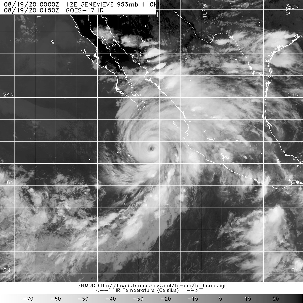
20200819.0150.goes-17.ir.12E.GENEVIEVE.110kts.953mb.19.1N.108.8W.100pc.jpg
回復

使用道具 舉報

123下一頁
快速回覆
您需要登錄後才可以回帖 登錄 | 立即加入

本版積分規則

本平台僅供學術討論之用,預報應以氣象局為準

威普網站虛擬主機贊助公司

臺灣第一個天氣類型社群平台 即時天氣資訊、精準颱風動態

線上客服
FB傳送訊息
廣告行銷
精準行銷 物超所值
官方粉專
發佈 快速回復 返回頂部 返回列表