簽到天數: 2100 天 [LV.Master]伴壇終老
|
 周子堯@FB|2020-8-15 09:42
|
顯示全部樓層
周子堯@FB|2020-8-15 09:42
|
顯示全部樓層
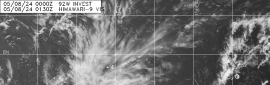
JTWC 01Z亦發布TCFA
1. FORMATION OF A SIGNIFICANT TROPICAL CYCLONE IS POSSIBLE WITHIN
160 NM EITHER SIDE OF A LINE FROM 9.9N 85.7W TO 11.5N 93.5W
WITHIN THE NEXT 12 TO 24 HOURS. AVAILABLE DATA DOES NOT JUSTIFY
ISSUANCE OF NUMBERED TROPICAL CYCLONE WARNINGS AT THIS TIME.
WINDS IN THE AREA ARE ESTIMATED TO BE 15 TO 20 KNOTS. METSAT
IMAGERY AT 150000Z INDICATES THAT A CIRCULATION CENTER IS LOCATED
NEAR 10.1N 86.5W. THE SYSTEM IS MOVING WESTWARD AT 16 KNOTS.
2. REMARKS: AN AREA OF CONVECTION (INVEST 95E) HAS PERSISTED NEAR
10.1N 86.5W, APPROXIMATELY 74 NM SOUTH-SOUTHWEST OF SAN JUAN DEL
SUR, NICARAGUA. ANIMATED ENHANCED INFRARED SATELLITE IMAGERY, ALONG
WITH A 150006Z SSMIS 91GHZ MICROWAVE IMAGE, SHOWS 95E TO BE A WEAK
LOW LEVEL CIRCULATION (LLC) THAT RECENTLY MOVED OVER THE PACIFIC
OCEAN. THERE IS SPARSE, DISORGANIZED DEEP CONVECTION ASSOCIATED WITH
THE LLC AT THIS TIME. 95E IS CURRENTLY IN A FAVORABLE ENVIRONMENT
WITH EXCELLENT EQUATORWARD OUTFLOW, DEVELOPING POLEWARD OUTFLOW, LOW
(15 TO 20 KNOT) VERTICAL WIND SHEAR, AND WARM (29 TO 30 CELSIUS) SEA
SURFACE TEMPERATURES. GLOBAL MODELS ARE IN GOOD AGREEMENT THAT 95E
WILL TRACK GENERALLY WEST-NORTHWESTWARD WITH QUICK CONSOLIDATION AND
INTENSIFICATION. MAXIMUM SUSTAINED SURFACE WINDS ARE ESTIMATED AT 15
TO 20 KNOTS. MINIMUM SEA LEVEL PRESSURE IS ESTIMATED TO BE NEAR 1007
MB. THE POTENTIAL FOR THE DEVELOPMENT OF A SIGNIFICANT TROPICAL
CYCLONE WITHIN THE NEXT 24 HOURS IS HIGH. 
|
評分
-
查看全部評分
|