開啟輔助訪問
 找回密碼
 立即加入

22L.Beta 墨西哥灣土生土長氣旋 登陸德州

簽到天數: 601 天

[LV.9]以壇為家II

霧峰追風者|2020-9-18 08:06 | 顯示全部樓層
252
WTNT42 KNHC 172300
TCDAT2

Tropical Depression Twenty-Two Special Discussion Number   1
NWS National Hurricane Center Miami FL       AL222020
600 PM CDT Thu Sep 17 2020

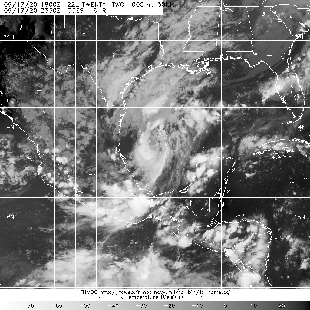
Reports from an Air Force Reserve Hurricane Hunter aircraft indicate
that the low pressure area over the southwestern Gulf of Mexico has
developed a sufficiently well-defined circulation, with SFMR wind
data suggesting an intensity of about 30 kt.  In addition, the
associated convection is organized enough for SAB and TAFB to
provide Dvorak satellite intensity estimates of 30 kt.  Based on
this information, advisories are being initiated on Tropical
Depression Twenty-Two.

The initial motion is a somewhat uncertain 035/4.  During the
next 48 h or so, the cyclone should be steered slowly
north-northeastward by a mid- to upper-level trough over Texas and
northern Mexico.  After that time, the global models are in good
agreement that this trough will weaken and lift out to the
northeast, with a weak mid-level ridge building to the north of the
cyclone.  This should result in a gradual turn toward the west at a
continued slow forward speed.  Although the cyclone is relatively
close to land, the vast majority of the track guidance keeps the
system offshore for the next five days.  The official forecast will
follow this scenario, with the forecast track being between the HCCA
corrected consensus and the other consensus models.

The large-scale models suggest that the cyclone will be in an
environment of light to moderate vertical wind shear for the next
several days.  Some dry air entrainment may occur after 48 h.  
The bulk of the intensity guidance keeps the system below hurricane
strength during the forecast period.  The official intensity
forecast follows the trend of the guidance and shows the system
peaking as a tropical storm, but it lies a little above the
intensity consensus.

As mentioned above, the cyclone is likely to stay offshore during
the forecast period.  Therefore, it is too early to tell which parts
of the coast of the Gulf of Mexico will get wind, storm surge, and
rain impacts from this system  


Key Messages:

1.  The system is expected to strengthen to a tropical storm while
moving slowly over the western Gulf of Mexico during the next few
days.

2.  While it is too early to determine what areas could see direct
wind, storm surge, and rainfall impacts from this system, interests
throughout the western Gulf of Mexico should monitor the progress of
this system and future updates to the forecast.


FORECAST POSITIONS AND MAX WINDS

INIT  17/2300Z 21.9N  94.3W   30 KT  35 MPH
12H  18/0600Z 22.7N  94.0W   30 KT  35 MPH
24H  18/1800Z 23.8N  93.5W   35 KT  40 MPH
36H  19/0600Z 24.8N  93.0W   45 KT  50 MPH
48H  19/1800Z 25.4N  92.9W   55 KT  65 MPH
60H  20/0600Z 25.8N  93.1W   60 KT  70 MPH
72H  20/1800Z 26.1N  93.8W   60 KT  70 MPH
96H  21/1800Z 26.1N  95.1W   55 KT  65 MPH
120H  22/1800Z 25.6N  96.1W   50 KT  60 MPH

$$
Forecaster Berg/Beven
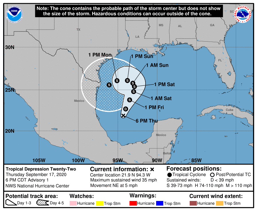
230146_5day_cone_no_line_and_wind.png 20200917.2330.goes-16.ir.22L.TWENTY-TWO.30kts.1005mb.21.8N.94.4W.100pc.jpg
回復

使用道具 舉報

簽到天數: 1650 天

[LV.Master]伴壇終老

老農民版夜神月|2020-9-18 00:39 | 顯示全部樓層
FWC-N發布TCFA,NHC展望亦提升90%,可能即將升格
WTNT21 KNGU 171100
SUBJ/TROPICAL CYCLONE FORMATION ALERT//
RMKS/1.FORMATION OF A SIGNIFICANT TROPICAL CYCLONE IS POSSIBLE
WITHIN A 100 NM RADIUS OF 21.1N 94.9W WITHIN THE NEXT 00 TO
24 HOURS. AVAILABLE DATA DOES NOT JUSTIFY ISSUANCE OF NUMBERED
TROPICAL CYCLONE WARNINGS AT THIS TIME. WINDS IN THE AREA ARE
ESTIMATED TO BE 15 TO 20 KNOTS. METSAT IMAGERY AT 170900Z INDICATES
THAT A CIRCULATION CENTER IS LOCATED NEAR 22.0N 96.0W.
THE SYSTEM IS QUASI-STATIONARY AT 00 KNOTS.
2.REMARKS: AN AREA OF DISORGANIZED SHOWERS AND THUNDERSTORMS A FEW
HUNDRED MILES NORTH-NORTHWEST OF THE YUCATAN PENINSULA IS ASSOCIATED
WITH A BROAD AREA OF LOW PRESSURE. ENVIRONMENTAL CONDITIONS ARE
MARGINALLY CONDUCIVE FOR DEVELOPMENT OF THIS SYSTEM AND A TROPICAL
DEPRESSION IS LIKELY TO FORM DURING THE NEXT 24 HOURS.
3. THIS ALERT WILL BE REISSUED, UPGRADED TO WARNING OR CANCELLED
BY 181100Z.//
BT
#0001
NNNN
1. Thunderstorm activity has continued to increase and become better
organized this morning in association with a well-defined low
pressure system located over the southwestern Gulf of Mexico.
Upper-level winds are gradually becoming more conducive for
development and, if this recent development trend continues, a
tropical depression or a tropical storm could form later today. The
low is expected to meander over the southwestern Gulf of Mexico for
the next day or so before moving slowly northward to northeastward
on Friday and Saturday.  An Air Force Reserve reconnaissance
aircraft is scheduled to investigate the disturbance this afternoon.
* Formation chance through 48 hours...high...90 percent.
* Formation chance through 5 days...high...90 percent.
al902020.gif two_atl_2d1 (2) (5).png

20200917.1600.goes-16.ir.90L.INVEST.30kts.1007mb.21.6N.94.6W.100pc.jpg 90L_gefs_latest.png
回復

使用道具 舉報

簽到天數: 1650 天

[LV.Master]伴壇終老

老農民版夜神月|2020-9-17 15:52 | 顯示全部樓層
NHC展望大幅提升至70%/90%
1. Thunderstorm activity associated with a low pressure system located
over the southwestern Gulf of Mexico has increased in coverage and
organization this morning. In addition, recent satellite-derived
surface wind data indicate that the low has become better defined.
Upper-level winds are expected to gradually become more conducive
for development, and a tropical depression is likely to form during
the next day or so while the low meanders over the southwestern Gulf
of Mexico. An Air Force Reserve reconnaissance aircraft is scheduled
to investigate the disturbance later today, if necessary.
* Formation chance through 48 hours...high...70 percent.
* Formation chance through 5 days...high...90 percent.
two_atl_2d1 (2) (4).png two_atl_5d1 (2) (2).png
20200917.0720.goes-16.ir.90L.INVEST.30kts.1007mb.21.1N.94.9W.100pc.jpg 90L_intensity_latest.png
回復

使用道具 舉報

簽到天數: 1650 天

[LV.Master]伴壇終老

老農民版夜神月|2020-9-17 01:15 | 顯示全部樓層
NHC展望提升至Medium,40%
1. An area of low pressure over the southwestern Gulf of Mexico is
producing showers and thunderstorms that have become a little better
organized during the past several hours.  Upper-level winds are
forecast to gradually become more conducive for development, and a
tropical depression could form late this week or over the weekend
while the low meanders over the southern Gulf of Mexico for the
next several days.
* Formation chance through 48 hours...medium...40 percent.
* Formation chance through 5 days...medium...60 percent.
two_atl_2d1.png 20200916.1640.goes-16.vis.2km.90L.INVEST.25kts.1008mb.20.8N.95.2W.pc.jpg
LATEST.jpg

回復

使用道具 舉報

12
快速回覆
您需要登錄後才可以回帖 登錄 | 立即加入

本版積分規則

本平台僅供學術討論之用,預報應以氣象局為準

威普網站虛擬主機贊助公司

臺灣第一個天氣類型社群平台 即時天氣資訊、精準颱風動態

線上客服
FB傳送訊息
廣告行銷
精準行銷 物超所值
官方粉專
發佈 快速回復 返回頂部 返回列表