開啟輔助訪問
 找回密碼
 立即加入

03P.Ruby 升格C1

簽到天數: 1650 天

[LV.Master]伴壇終老

老農民版夜神月|2021-12-13 17:47 | 顯示全部樓層
FMS06Z開始接手發報
65643.gif 65660.gif
TROPICAL DISTURBANCE ADVISORY NUMBER A1 ISSUED FROM RSMC NADI
Dec 130811 UTC.

TROPICAL CYCLONE RUBY CENTRE 980HPA WAS LOCATED NEAR 18.1S 160.8E AT
130600 UTC. POSITION POOR BASED ON HR HIMAWARI EIR AND PERIPHERAL
SURFACE REPORTS. CYCLONE MOVING EAST SOUTHEAST AT ABOUT 13 KNOTS.
MAXIMUM 10-MINUTE AVERAGE WINDS NEAR THE CENTRE ESTIMATED AT ABOUT 60
KNOTS INCREASING TO 70 KNOTS BY 131800UTC.

EXPECT WINDS OVER 47 KNOTS WITHIN 95 NAUTICAL MILES IN NE QUADRANT
AND WITHIN 80 NAUTICAL MILES IN SE QUADRANT
AND WITHIN 40 NAUTICAL MILES IN SW QUADRANT
AND WITHIN 60 NAUTICAL MILES IN NW QUADRANT
EXPECT WINDS OVER 33 KNOTS WITHIN 90 NAUTICAL MILES IN NE QUADRANT
AND WITHIN 90 NAUTICAL MILES IN SE QUADRANT
AND WITHIN 60 NAUTICAL MILES IN SW QUADRANT
AND WITHIN 60 NAUTICAL MILES IN NW QUADRANT.

TC RUBY CONTINUES ITS EAST SOUTHEAST TRACK WITH AN EMBEDDED CENTER.
CONVECTION IS REDUCED IN RADIAL EXTENT WITH CLOUD TOP WARMING.
ORGANISATION REMAINS GOOD WITH GOOD UPPER DIFFLUENT FLOW AND STRONG
UPPER DIVERGENCE BUT LLCC IN AREA OF MODERATE NORTHWESTERLY SHEAR.
SST AROUND 28 DEGRESS CELCIUS. SYSTEM CONTINUES TO BE STEERED EAST
SOUTHEAST BY THE SOUTHEASTERN PERIPHERY OF A NEAR EQUATORIAL RIDGE TO
THE NORTH. DVORAK BASED ON EMBEDDED PATTERN WITH CENTRE EMBEDDED IN
DG AND NO BANDING FEATURE YIELDING DT 4.0. MET 4.0 & PT 4.0. FT BASED
ON MET THUS T4.0/4.0/D1.0/24HRS.

FORECASTS :
AT 12 HRS VALID AT 131800 UTC 19.5S 163.1E MOV ESE AT 13 KT WITH 70
KT CLOSE TO CENTRE
AT 24 HRS VALID AT 140600 UTC 20.9S 165.8E MOV ESE AT 14 KT WITH 65
KT CLOSE TO CENTRE

OUTLOOK :
AT 36 HRS VALID AT 141800 UTC 22.6S 168.6E MOV ESE AT 14 KT WITH 60
KT CLOSE TO CENTRE
AT 48 HRS VALID AT 150600 UTC 25.0S 171.4E MOV SE AT 15 KT WITH 60 KT
CLOSE TO CENTRE

THE NEXT TROPICAL DISTURBANCE ADVISORY ON RUBY WILL BE ISSUED AROUND
131400 UTC.
20211213.0920.goes-17.ir.03P.RUBY.65kts.982mb.18.1S.161E.100pc.jpg 20211213.0802.f17.91pct91h91v.03P.RUBY.65kts.982mb.18.1S.161E.100pc.jpg 20211213.0802.f17.91h.03P.RUBY.65kts.982mb.18.1S.161E.100pc.jpg
回復

使用道具 舉報

簽到天數: 1650 天

[LV.Master]伴壇終老

老農民版夜神月|2021-12-13 17:43 | 顯示全部樓層
BoM00Z對Ruby發布最終報,06Z起將交由FMS發報
IDQ20018
TROPICAL CYCLONE TECHNICAL BULLETIN: AUSTRALIA - EASTERN REGION
Issued by AUSTRALIAN BUREAU OF METEOROLOGY TROPICAL CYCLONE WARNING CENTRE
at: 0140 UTC 13/12/2021
Name: Tropical Cyclone Ruby
Identifier: 07U
Data At: 0000 UTC
Latitude: 17.4S
Longitude: 159.7E
Location Accuracy: within 35nm (65 km)
Movement Towards: south southeast (151 deg)
Speed of Movement: 12 knots (22 km/h)
Maximum 10-Minute Wind: 60 knots (110 km/h)
Maximum 3-Second Wind Gust: 85 knots (155 km/h)
Central Pressure: 982 hPa
Radius of 34-knot winds NE quadrant: 90 nm (165 km)
Radius of 34-knot winds SE quadrant: 90 nm (165 km)
Radius of 34-knot winds SW quadrant: 60 nm (110 km)
Radius of 34-knot winds NW quadrant: 60 nm (110 km)
Radius of 48-knot winds NE quadrant: 25 nm (45 km)
Radius of 48-knot winds SE quadrant: 25 nm (45 km)
Radius of 48-knot winds SW quadrant: 15 nm (30 km)
Radius of 48-knot winds NW quadrant: 15 nm (30 km)
Radius of 64-knot winds:  nm ( km)
Radius of Maximum Winds: 25 nm (45 km)
Dvorak Intensity Code: T4.0/4.0/D1.5/24HRS STT: D0.5/06HRS
Pressure of outermost isobar: 1004 hPa
Radius of outermost closed isobar: 250 nm (465 km)
FORECAST DATA
Date/Time    : Location    : Loc. Accuracy: Max Wind   : Central Pressure
(UTC)        : degrees     :      nm  (km): knots(km/h): hPa
+06:  13/0600: 18.3S 160.6E:     055 (100):  060  (110):  980
+12:  13/1200: 19.1S 161.8E:     065 (125):  065  (120):  976
+18:  13/1800: 19.8S 163.0E:     075 (140):  070  (130):  971
+24:  14/0000: 20.4S 164.5E:     085 (160):  070  (130):  971
+36:  14/1200: 22.1S 167.7E:     100 (185):  060  (110):  979
+48:  15/0000: 24.5S 170.7E:     125 (230):  060  (110):  978
+60:  15/1200: 27.7S 174.0E:     160 (295):  055  (100):  981
+72:  16/0000: 32.8S 177.7E:     200 (370):  050  (095):  984
+96:  17/0000:             :              :            :     
+120: 18/0000:             :              :            :     
REMARKS:
TC Ruby has become more organise overnight with persistent deep convection
wrapping around the centre. Confidence in the system location is good based on
MW imagery and animated satellite imagery.

Dvorak intensity analysis is based on VIS curved band pattern with a 1.1 degree
wrap, giving a DT of 4.0. MET=3.5, PT=4 agrees with DT, FT=4.0. NOAA ADT T3.7,
CIMSS ADT higher at T4.5. SATCON=79 knots (1-min). The final intensity set to
60 knots, which is consistent with the AIDT 67 knots (1-min).

The 18UTC CIMSS vertical shear is estimated to be around 12 knots (NW) across
the system. Fairly good upper level outflow exists on the poleward side and
east of the system. Sea surface temperatures in the vicinity of the system are
generally 28+ degrees Celsius decreasing to 27C southwards to New Caledonia.

Recent imagery shows some warming of the cloud tops near the system, however
Ruby is expected to further intensify into a category 3 system as it moves
towards New Caledonia during the day or early Tuesday assisted by strong upper
outflow. The system would begin weakening from late Tuesday due to vicinity of
land areas and also due to increasing vertical wind shear and lower SSTs. The
system is likely to maintain a shallow warm core on Wednesday before undergoing
extra-tropical transition, while maintaining an intensity equivalent to a
category 2 tropical cyclone as it tracks to the northeast of the North Island
of New Zealand.

Ruby is expected to continue moving southeastwards under the influence of
increasing northwesterlies and will begin to accelerate from Wednesday onwards.
There is good confidence in the direction of the forecast track with the strong
steering, consequently there will be some uncertainty in the timing of the
track due to the speed.

Copyright Commonwealth of Australia
==
Next bulletin will be issued by Nadi Tropical Cyclone Warning Centre.
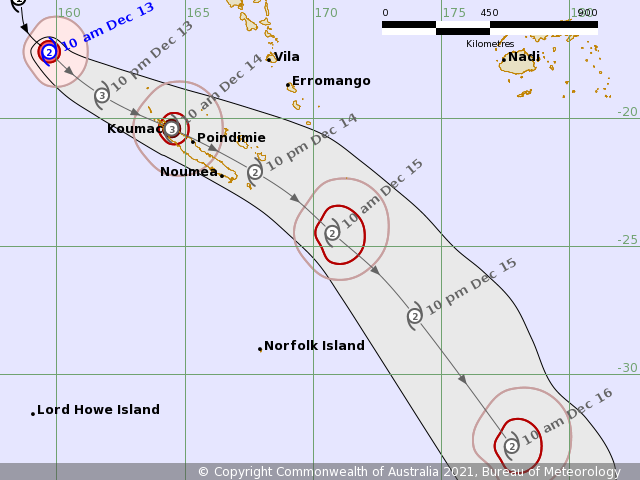
IDQ65001 (3).png
回復

使用道具 舉報

簽到天數: 1650 天

[LV.Master]伴壇終老

老農民版夜神月|2021-12-13 02:55 | 顯示全部樓層
JTWC升格C1
03P RUBY 211212 1800 16.4S 158.8E SHEM 65 983
03P_b13.gif 03P_b13bd.gif 03P_b13rbtop.gif
回復

使用道具 舉報

簽到天數: 1650 天

[LV.Master]伴壇終老

老農民版夜神月|2021-12-13 02:53 | 顯示全部樓層
BoM命名Ruby,目前定強澳式C2
IDQ20018
TROPICAL CYCLONE TECHNICAL BULLETIN: AUSTRALIA - EASTERN REGION
Issued by AUSTRALIAN BUREAU OF METEOROLOGY TROPICAL CYCLONE WARNING CENTRE
at: 1253 UTC 12/12/2021
Name: Tropical Cyclone Ruby
Identifier: 07U
Data At: 1200 UTC
Latitude: 15.3S
Longitude: 158.5E
Location Accuracy: within 30nm (55 km)
Movement Towards: southeast (136 deg)
Speed of Movement: 8 knots (15 km/h)
Maximum 10-Minute Wind: 40 knots (75 km/h)
Maximum 3-Second Wind Gust: 55 knots (100 km/h)
Central Pressure: 995 hPa
Radius of 34-knot winds NE quadrant: 60 nm (110 km)
Radius of 34-knot winds SE quadrant: 60 nm (110 km)
Radius of 34-knot winds SW quadrant: 40 nm (75 km)
Radius of 34-knot winds NW quadrant: 40 nm (75 km)
Radius of 48-knot winds NE quadrant:
Radius of 48-knot winds SE quadrant:
Radius of 48-knot winds SW quadrant:
Radius of 48-knot winds NW quadrant:
Radius of 64-knot winds:  nm ( km)
Radius of Maximum Winds: 20 nm (35 km)
Dvorak Intensity Code: T3.0/3.0/D1.0/24HRS STT:S0.0/06HRS
Pressure of outermost isobar: 1004 hPa
Radius of outermost closed isobar: 280 nm (520 km)
FORECAST DATA
Date/Time    : Location    : Loc. Accuracy: Max Wind   : Central Pressure
(UTC)        : degrees     :      nm  (km): knots(km/h): hPa
+06:  12/1800: 16.1S 159.2E:     045 (085):  045  (085):  988
+12:  13/0000: 17.0S 159.8E:     060 (105):  050  (095):  985
+18:  13/0600: 17.9S 160.9E:     065 (120):  055  (100):  982
+24:  13/1200: 18.7S 162.1E:     075 (135):  060  (110):  978
+36:  14/0000: 20.2S 164.9E:     085 (160):  065  (120):  974
+48:  14/1200: 21.8S 168.1E:     105 (195):  060  (110):  977
+60:  15/0000: 23.9S 171.3E:     120 (220):  060  (110):  977
+72:  15/1200: 27.0S 174.3E:     130 (245):  055  (100):  979
+96:  16/1200: 37.9S 175.8W:     165 (310):  050  (095):  984
+120: 17/1200:             :              :            :     
REMARKS:
Tropical cyclone Ruby maintains deep convection near centre with persistent
improved organisation. Confidence in the location is good based on ASCAT-B pass
at 1047Z. The F17 SSMIS 89GHz microwave pass at 0814Z indicated a strong
signature of deep convection wrapping more than halfway around the LLCC.

Dvorak intensity analysis is based on curved band pattern with a 0.5 degree
wrap, giving a DT of 2.5. MET=3.0, FT=3.0 based on MET. Objective guidance
estimates are - NOAA ADT is T3.3, CIMSS ADT is T3.6 and SATCON=57 knots
(1-min). The intensity estimate based on subjective Dvorak agrees with maximum
average winds of 40 knots picked by the ASCAT-B pass.

The CIMSS vertical shear is estimated to be around 10-15 knots across the
system. Fairly good upper level outflow exists on the poleward side with strong
upper divergence. Sea surface temperatures in the vicinity of the system are
generally 28-29 degrees Celsius extending northwards from New Caledonia.

Ruby is expected to remain in an environment conducive for further development
and is currently forecast to intensify into a category 3 system as it moves
towards New Caledonia during Monday and into Tuesday. Later this week, the
system is expected to encounter increased vertical wind shear into Thursday and
as a result, it should start to undergo extra-tropical transition, though
maintain an intensity equivalent to a category 2 tropical cyclone as it tracks
to the northeast of the North Island of New Zealand.

Ruby has began moving towards the southeast under the influence of a mid-level
high situated to the east of the syste and due to an upper trough moving from
the southwest. There is good confidence in the forecast movement with little
spread between global computer models and ensembles.

Copyright Commonwealth of Australia
==
The next bulletin for this system will be issued by: 12/1930 UTC.

IDQ65001 (2).png 20211212.1820.himawari-8.ir.03P.RUBY.55kts.991mb.15.7S.158.1E.100pc.jpg 20211212.1140.mtc.ASCAT.wind.03P.RUBY.50kts-994mb.158S.1582E.25km.noqc.jpg
回復

使用道具 舉報

簽到天數: 1650 天

[LV.Master]伴壇終老

老農民版夜神月|2021-12-12 03:55 | 顯示全部樓層
JTWC升格03P
03P THREE 211211 1800 12.8S 156.9E SHEM 35 1001
20211211.1910.himawari-8.ir.03P.THREE.35kts.1001mb.12.8S.156.9E.100pc.jpg IDQ65001 (1).png
回復

使用道具 舉報

簽到天數: 1650 天

[LV.Master]伴壇終老

老農民版夜神月|2021-12-12 00:44 | 顯示全部樓層
T值已達2.5,JTWC若無意外稍後即將升格
TPPS10 PGTW 111506

A. TROPICAL DISTURBANCE 93P (NW OF NEW CALEDONIA)

B. 11/1440Z

C. 12.05S

D. 156.84E

E. FIVE/HMWRI8

F. T2.5/2.5/D1.5/24HRS  STT: S0.0/03HRS

G. IR/EIR

H. REMARKS: 38A/PBO SBC/ANMTN. CNVCTN WRAPS .50 ON LOG10 SPIRAL
YIELDING A DT OF 2.5. MET AND PT AGREE. DBO DT.

I. ADDITIONAL POSITIONS: NONE


   ABRAHAM
20211211.1610.himawari-8.ir.93P.INVEST.30kts.1000mb.11.5S.156.5E.100pc.jpg 93P_gefs_latest (2).png aus (3).png
回復

使用道具 舉報

簽到天數: 1650 天

[LV.Master]伴壇終老

老農民版夜神月|2021-12-11 02:58 | 顯示全部樓層
JTWC18Z提升定強至30節,南大首旋今日或將誕生
93P INVEST 211210 1200 11.6S 155.6E SHEM 25 1004
93P INVEST 211210 1800 10.4S 155.3E SHEM 30 1000

20211210.143000.SH932022.ahi.himawari-8.Infrared-Gray.25kts.100p0.1p0.jpg 20211210.084300.SH932022.ssmis.F17.color89.25kts.61p8.1p0.jpg 20211210.144251.SH932022.amsr2.gcom-w1.color89.25kts.75p2.1p0.jpg
回復

使用道具 舉報

簽到天數: 1650 天

[LV.Master]伴壇終老

老農民版夜神月|2021-12-11 02:46 | 顯示全部樓層
BoM開始發報,上望澳式C3,65節
IDQ20018
TROPICAL CYCLONE TECHNICAL BULLETIN: AUSTRALIA - EASTERN REGION
Issued by AUSTRALIAN BUREAU OF METEOROLOGY TROPICAL CYCLONE WARNING CENTRE
at: 1315 UTC 10/12/2021
Name: Tropical Low  
Identifier: 07U
Data At: 1200 UTC
Latitude: 10.5S
Longitude: 155.4E
Location Accuracy: within 45nm (85 km)
Movement Towards: east southeast (117 deg)
Speed of Movement: 2 knots (4 km/h)
Maximum 10-Minute Wind: 25 knots (45 km/h)
Maximum 3-Second Wind Gust: 45 knots (85 km/h)
Central Pressure: 1002 hPa
Radius of 34-knot winds NE quadrant:
Radius of 34-knot winds SE quadrant:
Radius of 34-knot winds SW quadrant:
Radius of 34-knot winds NW quadrant:
Radius of 48-knot winds NE quadrant:
Radius of 48-knot winds SE quadrant:
Radius of 48-knot winds SW quadrant:
Radius of 48-knot winds NW quadrant:
Radius of 64-knot winds:  nm ( km)
Radius of Maximum Winds:   nm (  km)
Dvorak Intensity Code: T2.0/2.0/D1.0/24HRS STT:D0.5/06HRS
Pressure of outermost isobar: 1005 hPa
Radius of outermost closed isobar: 180 nm (335 km)
FORECAST DATA
Date/Time    : Location    : Loc. Accuracy: Max Wind   : Central Pressure
(UTC)        : degrees     :      nm  (km): knots(km/h): hPa
+06:  10/1800: 10.8S 155.8E:     080 (145):  030  (055):  999
+12:  11/0000: 11.2S 156.1E:     065 (120):  030  (055): 1000
+18:  11/0600: 11.7S 156.3E:     075 (140):  035  (065):  997
+24:  11/1200: 12.1S 156.6E:     085 (155):  035  (065):  997
+36:  12/0000: 13.3S 157.3E:     110 (200):  045  (085):  992
+48:  12/1200: 15.0S 158.3E:     115 (215):  055  (100):  986
+60:  13/0000: 16.7S 159.6E:     135 (250):  060  (110):  982
+72:  13/1200: 18.5S 161.6E:     165 (310):  065  (120):  977
+96:  14/1200: 21.6S 166.9E:     215 (395):  050  (095):  987
+120: 15/1200: 25.9S 172.7E:     265 (485):  050  (095):  986
REMARKS:
Location is based on animated IR.

The system has shown increased organisation over the past 24 hours with deep
convection on the southern side wrapping around the western side. For now, the
wrap of deep convection remains segmented. Dvorak analysis using curved band
measures 0.3 wrap on the western band, yielding a DT=2.0. However there is low
confidence in DT due to the segmented nature of convection. A D- trend produces
MET=1.5, FT is based on PT=2.0. Objective guidance isn't available yet. Maximum
winds are estimated around 25 knots.

The system is in area of low shear with under the influence of an upper ridge
to it's northeast. CMISS indicates an upper trough located over eastern
Australia is providing strong upper divergence to the south of the system.
MIMIC TPW indicates a very moist environment. SSTs are 29-30C in the area.  

NWP is inconsistent with intensification rates. Many of the higher resolution
models are producing an unusually symmetrical and stronger system with an
indication of steep intensification in the 24 to 48 hour period. While others
have a slowly developing system with the stronger winds predominantly on the
eastern side. While conditions are mostly favourable for development, vertical
wind shear amy increase substantially as the upper trough to the west becomes
more influential. A Dvorak standard rate of development is forecast with a
category 3 system approaching New Caledonia early next week.   

Global and high res model guidance are consistent with the system moving
southeastwards during the weekend ahead of the approaching upper trough to the
west.

Copyright Commonwealth of Australia
==
The next bulletin for this system will be issued by: 10/1930 UTC.
IDQ65001.png 網頁擷取_11-12-2021_24412_www.bom.gov.au.jpeg
93P_b13.gif 93P_b13rbtop.gif
回復

使用道具 舉報

快速回覆
您需要登錄後才可以回帖 登錄 | 立即加入

本版積分規則

本平台僅供學術討論之用,預報應以氣象局為準

威普網站虛擬主機贊助公司

臺灣第一個天氣類型社群平台 即時天氣資訊、精準颱風動態

線上客服
FB傳送訊息
廣告行銷
精準行銷 物超所值
官方粉專
發佈 快速回復 返回頂部 返回列表