|
|
 krichard2011|2014-10-13 01:26
|
顯示全部樓層
krichard2011|2014-10-13 01:26
|
顯示全部樓層
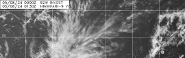
NHC 評級 HIGH
整體螺旋性算是相當好
不過對流方面還有待加強
數值大致看好後期進入大西洋發展
Updated: The small low pressure system located a couple of hundred
miles east of the Leeward Islands is continuing to show signs of
organization. An Air Force Reserve reconnaissance aircraft will
be investigating the system this afternoon to determine if a
tropical depression or a tropical storm has formed. Environmental
and ocean conditions are expected to generally be conducive for
additional development while the low moves westward at 10 to 15 mph.
Interests from the Leeward Islands and Puerto Rico to Hispaniola and
the southeastern Bahamas should monitor the progress of this system
since tropical storm warnings and watches could be required for
portions of the Leeward Islands, the Virgin Islands, and Puerto Rico
later this morning or afternoon. Regardless of development, locally
heavy rainfall and strong gusty winds are expected to move across
the Leeward Islands starting later today.
* Formation chance through 48 hours...high...90 percent.
* Formation chance through 5 days...high...90 percent. |
本帖子中包含更多資源
您需要 登錄 才可以下載或查看,沒有賬號?立即加入
x
評分
-
查看全部評分
|