簽到天數: 1650 天 [LV.Master]伴壇終老
|
 老農民版夜神月|2019-9-18 21:39
|
顯示全部樓層
補充下資料,09L.Humberto18/03Z已達MH
WTNT44 KNHC 180256
TCDAT4
Hurricane Humberto Discussion Number 22
NWS National Hurricane Center Miami FL AL092019
1100 PM EDT Tue Sep 17 2019
Humberto has an impressive presentation on satellite images, with a
large 30-40 n mi diameter eye surrounded by very cold cloud tops.
An Air Force Reserve Unit Hurricane Hunter aircraft investigating
the hurricane found SFMR-observed surface winds of 98 kt and peak
700-mb flight-level winds of 111 kt. Based on these observations,
the current intensity was set at 100 kt, which made the system a
major hurricane. Some fluctuations in strength due to a potential
eyewall replacement are possible during the next 24 hours or so, but
strong southwesterly shear should result in a weakening trend to
commence on Thursday. In 72 hours, the global models show the
system merging with a frontal zone so the NHC forecast calls for
extratropical transition by that time. The official intensity
forecast follows the model consensus.
Center fixes from the Hurricane Hunters indicate that the motion
continues to be east-northeastward or 075/10 kt. Humberto is
likely to turn toward the northeast and north-northeast at a faster
forward speed in 24-36 hours as it interacts with a strong mid-level
trough at mid-latitudes to its north and northeast. Later in the
forecast period, the track guidance indicates that Humberto will
turn back toward the east-northeast as it moves in tandem with the
mid-latitude trough over the north Atlantic. The official forecast
is in close agreement with the simple and corrected consensus
models, TVCA and HCCA.
Key Messages:
1. Hurricane conditions are expected in Bermuda Wednesday night and
Thursday morning, with tropical-storm-force winds expected by
Wednesday afternoon. Residents there should follow advice given by
local officials.
2. Storm surge and dangerous breaking waves could cause coastal
flooding Wednesday night and Thursday along the southern coast of
Bermuda.
3. Swells will continue to affect the northwestern Bahamas and the
southeastern coast of the United States from east-central Florida to
North Carolina during the next couple of days, creating life-
threatening surf and rip current conditions.
FORECAST POSITIONS AND MAX WINDS
INIT 18/0300Z 31.3N 71.0W 100 KT 115 MPH
12H 18/1200Z 32.0N 68.9W 100 KT 115 MPH
24H 19/0000Z 33.4N 65.5W 100 KT 115 MPH
36H 19/1200Z 36.0N 62.0W 90 KT 105 MPH
48H 20/0000Z 38.6N 60.2W 75 KT 85 MPH
72H 21/0000Z 42.5N 56.0W 55 KT 65 MPH...POST-TROP/EXTRATROP
96H 22/0000Z 44.0N 44.0W 50 KT 60 MPH...POST-TROP/EXTRATROP
120H 23/0000Z 49.0N 26.0W 45 KT 50 MPH...POST-TROP/EXTRATROP
$$
Forecaster Pasch
WTNT44 KNHC 180847
TCDAT4
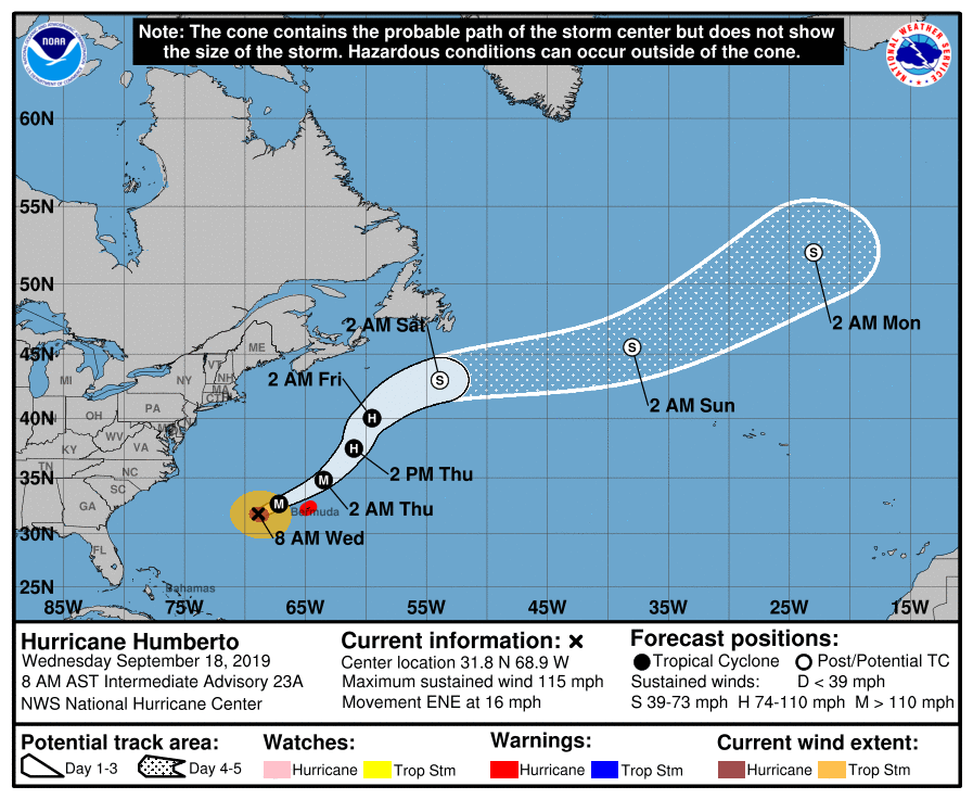
Hurricane Humberto Discussion Number 23
NWS National Hurricane Center Miami FL AL092019
500 AM AST Wed Sep 18 2019
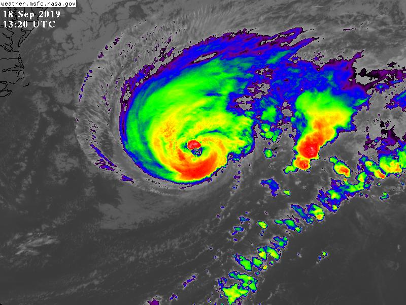
Humberto's satellite presentation continues to be outstanding with
a large ragged eye and surrounded by deep convection. The eye of the
hurricane is very near NOAA Buoy 41048 and most likely will passing
over it by the time this advisory is being released. The pressure
from the buoy has been dropping fast and is now at 961 mb and the
sustained winds have reached 58 kt with gusts to 78 kt. Based on
satellite appearance and continuity, the initial intensity is kept
at 100 kt. Another Hurricane Hunter aircraft will check the cyclone
in a few hours.
Some fluctuations in strength due to a potential eyewall replacement
are possible during the next 12 to 24 hours or so. After that time
very strong southwesterly wind shear should impact the hurricane
resulting in weakening. In 72 hours or earlier, the global models
show the system merging with a frontal zone, so the NHC forecast
calls for extratropical transition by that time. The official
intensity forecast follows the corrected consensus HCCA and is not
very different from the previous one.
Humberto is accelerating, and satellite fixes yield an initial
motion toward the east-northeast or 065 degrees at 14 kt. Humberto
is located at the base of a strong mid-to upper-level trough, and
the hurricane will likely interact with this amplifying trough. This
should force Humberto to turn toward the northeast and north-
northeast at a faster forward speed in 24-36 hours. Later in the
forecast period, the track guidance indicates that Humberto will
turn back toward the east-northeast while becoming embedded within
the mid-latitude westerlies. The NHC track forecast is very similar
to the previous one and is in the middle of the guidance envelope.
Key Messages:
1. Hurricane conditions are expected in Bermuda tonight and Thursday
morning, with tropical-storm-force winds expected to begin later
today. Residents there should follow advice given by local
officials.
2. Storm surge and dangerous breaking waves could cause coastal
flooding tonight and Thursday along the southern coast of Bermuda.
3. Swells will continue to affect the northwestern Bahamas and the
southeastern coast of the United States from east-central Florida to
North Carolina during the next couple of days, creating life-
threatening surf and rip current conditions.
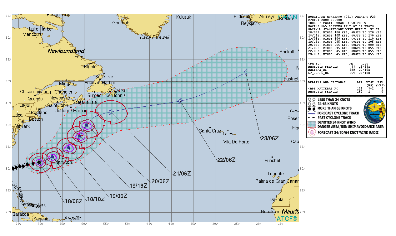
FORECAST POSITIONS AND MAX WINDS
INIT 18/0900Z 31.7N 69.6W 100 KT 115 MPH
12H 18/1800Z 32.7N 67.2W 105 KT 120 MPH
24H 19/0600Z 34.8N 63.5W 100 KT 115 MPH
36H 19/1800Z 37.5N 61.0W 85 KT 100 MPH
48H 20/0600Z 40.0N 59.5W 65 KT 75 MPH
72H 21/0600Z 43.0N 53.9W 45 KT 50 MPH...POST-TROP/EXTRATROP
96H 22/0600Z 45.5N 38.0W 45 KT 50 MPH...POST-TROP/EXTRATROP
120H 23/0600Z 52.1N 23.0W 45 KT 50 MPH...POST-TROP/EXTRATROP
$$
Forecaster Avila 


|
|