開啟輔助訪問
 找回密碼
 立即加入

01C.Walaka 中太時隔32個月迎土產氣旋 猛烈爆發成為C5

簽到天數: 3280 天

[LV.Master]伴壇終老

t02436|2018-10-1 17:21 | 顯示全部樓層
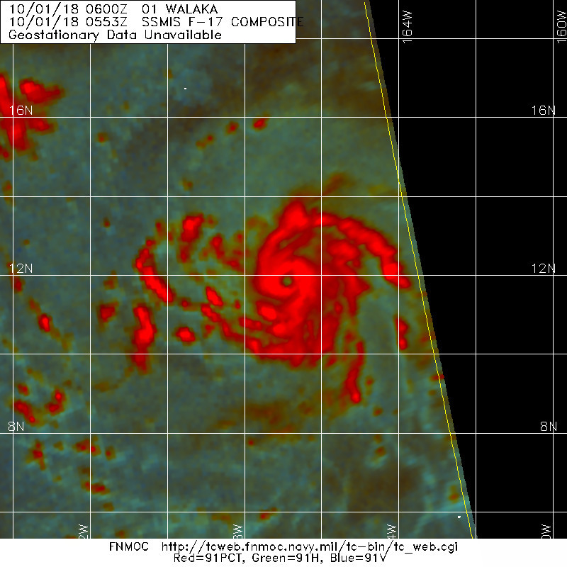
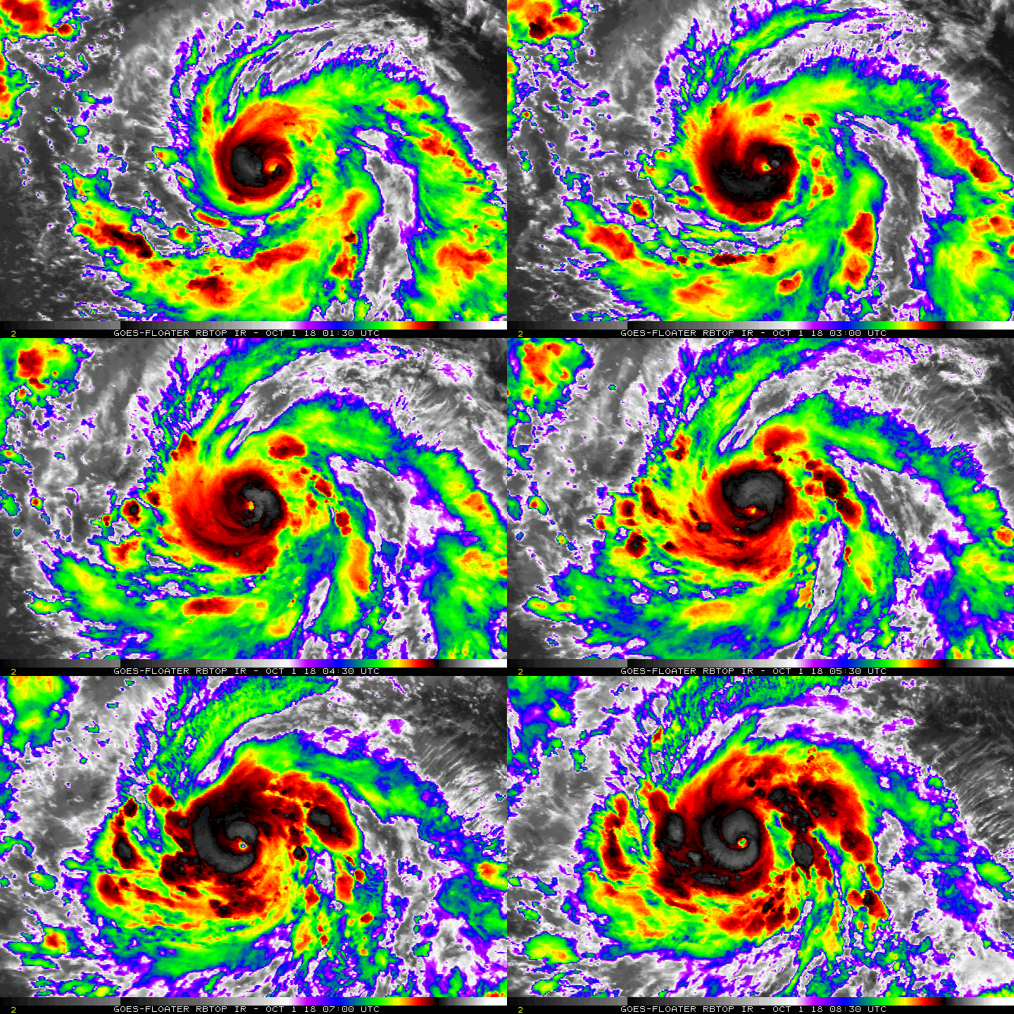
隔壁棚的Walaka也進入RI,09Z評價90節,巔峰上望135節!
WTPA41 PHFO 010925
TCDCP1

Hurricane Walaka Discussion Number   7
NWS Central Pacific Hurricane Center Honolulu HI   CP012018
1100 PM HST Sun Sep 30 2018

Walaka is undergoing rapid intensification this evening, which is
clearly evident given the large ring of -70 to -85C cloud tops
surrounding the the well defined eye. Additionally, recent
microwave passes indicate that the organization of the system has
improved significantly, while geostationary satellite animations
show well defined outflow channels in all quadrants. The latest
intensity estimates came in at 5.0 (90 knots) from PHFO and SAB, 4.5
(77 knots) from JTWC, while the UW-CIMSS ADT was 4.2 (70 knots).
Based on the significant improvement in appearance and organization
of Walaka, the initial intensity for this advisory was increased to
90 knots. The initial motion was set at 280/10 knots.

Walaka continues to be steered westward this evening by a
subtropical ridge to the north of the system, and this motion is
expected to continue tonight. A turn toward the northwest is
expected on Monday as a deep north Pacific upper trough digs
southward in the vicinity of 30N 170W. A turn toward the north is
then expected on Tuesday, with Walaka continuing on this course
through Tuesday night with an increase in forward speed. The
tropical cyclone should then make a turn toward the north-northeast
Wednesday and Wednesday night as it begins to feel the influence of
the deep upper level trough. The track guidance then suggests a
shift back toward the north with a decrease in forward speed
Thursday through Friday as Walaka interacts with the deep upper
level trough. The official forecast was nudged slightly to the left
through 48 hours, then slightly to the right beyond 48 hours, and
is very close to the HCCA, TVCN, and GFEX consensus guidance.

The environment surrounding Walaka remains very conducive for
additional intensification through 48 hours. The tropical cyclone
will remain within a deep moist airmass, with vertical wind shear
forecast to remain around 10 knots or less through 48 hours, and
sea surface temperatures holding in the 84 to 86 Fahrenheit range
during this time. As a result, additional rapid intensification is
expected tonight and Monday, with the cyclone then forecast to level
off just below category 5 status Tuesday and Tuesday night. Given
the environment surrounding the system, intensification to a
category 5 storm is not out of the question, although none of the
intensity guidance explicitly indicate this at this time.

Additionally, Walaka will likely undergo eyewall replacement cycles
which will lead to some fluctuation in intensity. Beyond 48 hours,
vertical wind shear will steadily increase as Walaka approaches and
begins to interact with the deep upper level trough over the
north-central Pacific, with sea surface temperatures dropping off as
well. The intensity forecast shows a gradual weakening by 72 hours,
with rapid weakening then expected beyond 72 hours through the end
of the forecast period. The official intensity forecast has been
increased from the previous advisory and is in line with the high
end of the intensity guidance.


FORECAST POSITIONS AND MAX WINDS

INIT  01/0900Z 11.9N 167.5W   90 KT 105 MPH
12H  01/1800Z 12.5N 168.7W  115 KT 130 MPH
24H  02/0600Z 13.5N 169.9W  130 KT 150 MPH
36H  02/1800Z 15.1N 170.5W  135 KT 155 MPH
48H  03/0600Z 17.2N 170.5W  135 KT 155 MPH

72H  04/0600Z 23.3N 168.1W  115 KT 130 MPH
96H  05/0600Z 28.5N 167.5W   75 KT  85 MPH
120H  06/0600Z 31.0N 166.0W   60 KT  70 MPH

$$
Forecaster Jelsema
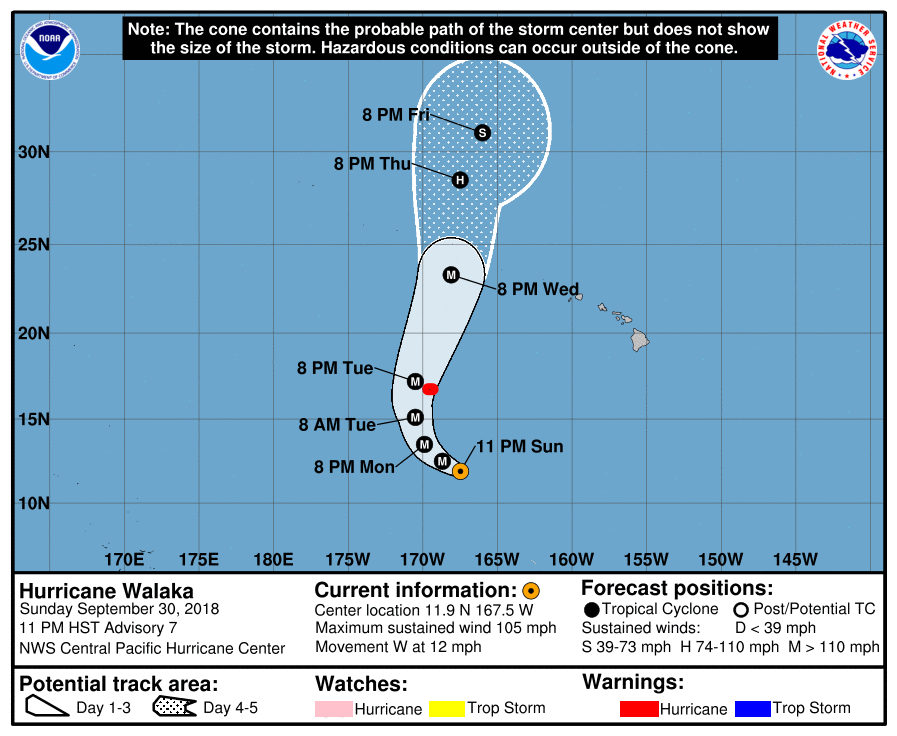
CP012018_5day_cone_no_line_7.png

20181001.0553.f17.91pct91h91v.01C.WALAKA.90kts.970mb.11.8N.167W.075pc.jpg

rbtop-animated.gif
回復

使用道具 舉報

簽到天數: 601 天

[LV.9]以壇為家II

霧峰追風者|2018-9-30 08:40 | 顯示全部樓層
CPHC 21Z命名"WALAKA",巔峰上望MH。
WTPA41 PHFO 292107
TCDCP1

Tropical Storm Walaka Discussion Number   1
NWS Central Pacific Hurricane Center Honolulu HI   CP012018
1100 AM HST Sat Sep 29 2018

The tropical disturbance passing far south of the main Hawaiian
Islands has developed persistent deep convection near the center
with a banding feature developing within the eastern and southern
quadrants. A series of SSMI and SSMIS passes between 1348 and 1716
UTC showed this structure and provided some indication of the
location of the low level circulation center. Subjective Dvorak
current intensity estimates from JTWC and SAB were constrained to
2.0/30 kt, with data T numbers coming in at 2.5/35 kt, and the
current intensity from HFO was 2.5/35 kt. These inputs support
initiating advisories for Tropical Storm Walaka, the sixth tropical
cyclone of 2018 in the Central Pacific basin and the first to form
in the basin this year.

Walaka is moving toward the west (265 degrees) at 13 kt. A westward
motion will continue for the next 36 hours or so as the system
remains south of a deep ridge. This will take Walaka well southwest
of the main Hawaiian Islands. Late Sunday through Monday night, the
cyclone will make a gradual turn toward the northwest then north as
a deep North Pacific trough digs southward and steadily erodes the
ridge. As a result, Walaka will pass very close to Johnston Island
as early as Monday night and likely sometime Tuesday. The deep
trough will stall roughly along 171W longitude on Tuesday, causing
the tropical cyclone to accelerate northward. On days four and
five, the motion becomes uncertain due to model differences in the
handling of the interaction between Walaka with the deep trough. The
track forecast follows a rather tightly clustered guidance envelope
through Tuesday, then favors the HMON, which is closer to TVCE than
the faster GFS and slower ECMWF. Due to the uncertainty in the long
term motion, interests in the Papahanaumokuakea Marine National
Monument should monitor Walaka.

Strengthening, possibly rapid, is expected through the next three
days, and Walaka is forecast to remain intense through day five.
Walaka will remain under low vertical wind shear and over SSTs of
around 29C through at least Monday, and likely into Tuesday. In this
environment, the SHIPS rapid intensification guidance for Walaka is
well above the climatological mean. The intensity forecast is close
to LGEM and ICON through the initial 48 hours and remains near the
HWRF and ICON, but below LGEM, thereafter. Walaka is forecast to
become a hurricane by Sunday, and along the forecast track,
hurricane conditions could be experienced on Johnston Island as
early as Monday night. Some weakening is indicated beyond Tuesday
due to increasing southwesterly vertical wind shear.


FORECAST POSITIONS AND MAX WINDS

INIT  29/2100Z 11.5N 159.1W   35 KT  40 MPH
12H  30/0600Z 11.5N 161.5W   45 KT  50 MPH
24H  30/1800Z 11.8N 164.2W   60 KT  70 MPH
36H  01/0600Z 12.5N 166.6W   75 KT  85 MPH
48H  01/1800Z 13.4N 168.4W   90 KT 105 MPH
72H  02/1800Z 16.5N 169.6W  110 KT 125 MPH
96H  03/1800Z 21.4N 168.5W  100 KT 115 MPH
120H  04/1800Z 27.0N 168.0W   80 KT  90 MPH

$$
Forecaster Wroe
CP012018_5day_cone_no_line_1.png 20180930.0000.himawari-8.vis.01C.INVEST.35kts.1005mb.11.5N.158.6W.100pc.jpg rgb-animated (6).gif rbtop-animated (15).gif


回復

使用道具 舉報

簽到天數: 2119 天

[LV.Master]伴壇終老

周子堯@FB|2018-9-30 08:35 | 顯示全部樓層
NHC命名01C.Walaka

ZCZC HFOTWOCP ALL
TTAA00 PHFO DDHHMM

Tropical Weather Outlook
NWS Central Pacific Hurricane Center Honolulu HI
200 PM HST Sat Sep 29 2018

For the central North Pacific...between 140W and 180W:

The Central Pacific Hurricane Center is issuing advisories on
Tropical Storm Walaka, centered about 675 miles south of Honolulu,
Hawaii.

Elsewhere, no tropical cyclones are expected during the next 5
days.

Public Advisories on Tropical Storm Walaka are issued under WMO
header WTPA31 PHFO and under AWIPS header HFOTCPCP1.
Forecast Advisories on Tropical Storm Walaka are issued under WMO
header WTPA21 PHFO and under AWIPS header HFOTCMCP1.

$$
Forecaster Kino
NNNN
CP012018_5day_cone_no_line_1.png
cp0118.gif
vis_lalo-animated-01C.gif


回復

使用道具 舉報

簽到天數: 2119 天

[LV.Master]伴壇終老

周子堯@FB|2018-9-29 17:43 | 顯示全部樓層
JTWC 28/21Z發布TCFA,數值看好發展

1. FORMATION OF A SIGNIFICANT TROPICAL CYCLONE IS POSSIBLE WITHIN
150 NM EITHER SIDE OF A LINE FROM 12.4N 152.1W TO 12.6N 158.9W
WITHIN THE NEXT 12 TO 24 HOURS. AVAILABLE DATA DOES NOT JUSTIFY
ISSUANCE OF NUMBERED TROPICAL CYCLONE WARNINGS AT THIS TIME.
WINDS IN THE AREA ARE ESTIMATED TO BE 20 TO 25 KNOTS. METSAT
IMAGERY AT 282000Z INDICATES THAT A CIRCULATION CENTER IS LOCATED
NEAR 12.3N 153.0W. THE SYSTEM IS MOVING WESTWARD AT 15 KNOTS.
2. REMARKS: THE AREA OF CONVECTION (INVEST 97C) PREVIOUSLY LOCATED
NEAR 12.4N 146.4W, IS NOW LOCATED NEAR 12.3N 153.0W, APPROXIMATELY
465 NM SOUTH-SOUTHEAST OF HILO, HAWAII. ANIMATED ENHANCED INFRARED
SATELLITE IMAGERY AND A 281843Z 89 GHZ MHS IMAGE DEPICT A BROAD LOW
LEVEL CIRCULATION WITH BROAD DEEP CONVECTION. THE UPPER LEVEL
ENVIRONMENT IS FAVORABLE, WITH LOW (5-10 KTS) VWS AND ADEQUATE UPPER
LEVEL DIVERGENCE DUE TO STRONG POLEWARD OUTFLOW. SSTS REMAIN
FAVORABLE (28-30 CELSIUS) IN THE REGION. GLOBAL MODELS GENERALLY
AGREE ON THE STORM DEVELOPING OVER THE NEXT FEW DAYS WHILE TRACKING
SLOWLY TO THE WEST. MAXIMUM SUSTAINED SURFACE WINDS ARE ESTIMATED AT
20 TO 25 KNOTS. MINIMUM SEA LEVEL PRESSURE IS ESTIMATED TO BE NEAR
1004 MB. THE POTENTIAL FOR THE DEVELOPMENT OF A SIGNIFICANT TROPICAL
CYCLONE WITHIN THE NEXT 24 HOURS REMAINS HIGH. THIS SUPERSEDES REF A
(WTPN21 PHNC 272100).
cp9718.gif
vis_lalo-animated-97C.gif


回復

使用道具 舉報

簽到天數: 601 天

[LV.9]以壇為家II

霧峰追風者|2018-9-28 09:34 | 顯示全部樓層
CPHC 展望提升至70%。
1. Showers and thunderstorms associated with a low level circulation
center located about 600 miles southeast of Hilo, Hawaii continues
to become better organized. Environmental conditions remain
conducive for this system to become a tropical depression this week
while it moves west at around 15 mph.
* Formation chance through 48 hours...high...70 percent.
* Formation chance through 5 days...high...90 percent.
two_cpac_2d1 (2).png rbtop-animated (12).gif

回復

使用道具 舉報

簽到天數: 601 天

[LV.9]以壇為家II

霧峰追風者|2018-9-28 02:55 | 顯示全部樓層
CPHC 展望提升至60%,數值看好發展。
1. Showers and thunderstorms associated with a low level circulation
center located about 700 miles southeast of Hilo, Hawaii continues
to become better organized. Environmental conditions remain
conducive for this system to become a tropical depression this week
while it moves west 10 to 15 mph.
* Formation chance through 48 hours...Medium...60 percent.
* Formation chance through 5 days...High...90 percent.
two_cpac_2d1 (1).png 20180927.1800.goes-15.vis.1km.97C.INVEST.25kts.1008mb.12.3N.145.4W.100pc.jpg 97C_gefs_latest.png

點評

看這路徑是直接跨入西太平洋,過去強度來看,是還沒升格風暴,猜測是西太平洋上的第26號颱風玉兔。  發表於 2018-9-28 05:23
回復

使用道具 舉報

12
快速回覆
您需要登錄後才可以回帖 登錄 | 立即加入

本版積分規則

本平台僅供學術討論之用,預報應以氣象局為準

威普網站虛擬主機贊助公司

臺灣第一個天氣類型社群平台 即時天氣資訊、精準颱風動態

線上客服
FB傳送訊息
廣告行銷
精準行銷 物超所值
官方粉專
發佈 快速回復 返回頂部 返回列表