開啟輔助訪問
 找回密碼
 立即加入

12E.Linda 發展超乎預期 巔峰達C4 西行進入中太

簽到天數: 3280 天

[LV.Master]伴壇終老

t02436|2021-8-19 23:31 | 顯示全部樓層
快速減弱,15Z已降到60節,明天就會進入中太,4天後將以後熱帶氣旋強度通過夏威夷北方外海。
143737_5day_cone_with_line.png
513
WTPZ42 KNHC 191436
TCDEP2

Tropical Storm Linda Discussion Number  38
NWS National Hurricane Center Miami FL       EP122021
500 AM HST Thu Aug 19 2021

Linda has weakened rapidly over the past several hours. The
cyclone no longer has an eye, and its deep convection is dissipating
and becoming confined mainly to the north of the low-level center.
The latest Dvorak intensity estimates from TAFB and SAB both
indicate that the initial intensity has decreased to 60 kt, making
Linda a tropical storm.

The initial motion estimate is now 280/14 kt. This general motion is
forecast to continue for the next several days as the cyclone
remains in the flow to the south of a strong subtropical ridge. The
model track guidance is in very good agreement, and the latest NHC
track forecast lies near the various consensus model solutions.

The cooler waters of 24-25 C and dry, stable air are taking their
toll on Linda. These conditions are not supportive of the return of
deep convection, and therefore the cyclone should continue to
quickly weaken in the short term. Based on the convective trends,
there is a possibility that Linda could degenerate into a
post-tropical gale within the next couple of days. The NHC forecast
is conservative and shows Linda remaining a tropical cyclone through
Saturday. The latest NHC intensity forecast remains similar to the
IVCN and HCCA intensity consensus models.


FORECAST POSITIONS AND MAX WINDS

INIT  19/1500Z 19.9N 137.6W   60 KT  70 MPH
12H  20/0000Z 20.3N 139.9W   50 KT  60 MPH
24H  20/1200Z 20.7N 142.9W   40 KT  45 MPH
36H  21/0000Z 21.0N 145.6W   35 KT  40 MPH
48H  21/1200Z 21.3N 148.0W   35 KT  40 MPH
60H  22/0000Z 21.7N 150.3W   35 KT  40 MPH...POST-TROPICAL
72H  22/1200Z 22.0N 152.4W   35 KT  40 MPH...POST-TROPICAL
96H  23/1200Z 22.7N 157.0W   30 KT  35 MPH...POST-TROP/REMNT LOW
120H  24/1200Z 23.2N 162.3W   30 KT  35 MPH...POST-TROP/REMNT LOW

$$
Forecaster Latto

goes17_rainbow_12E.gif

GOES15202021231zKd7aO.jpg
回復

使用道具 舉報

簽到天數: 1650 天

[LV.Master]伴壇終老

老農民版夜神月|2021-8-19 05:31 | 顯示全部樓層
12E_RBTOP.gif

型態以肉眼可見的開始衰弱.並且根據NHC的預測
其即將開始以大約12H10KT的速度快速減弱
INIT  18/2100Z 18.7N 133.2W   85 KT 100 MPH
12H  19/0600Z 19.3N 135.3W   75 KT  85 MPH
24H  19/1800Z 20.0N 138.3W   65 KT  75 MPH
36H  20/0600Z 20.6N 141.4W   55 KT  65 MPH
48H  20/1800Z 21.0N 144.2W   50 KT  60 MPH
60H  21/0600Z 21.3N 146.7W   45 KT  50 MPH
72H  21/1800Z 21.8N 149.0W   40 KT  45 MPH...POST-TROPICAL
96H  22/1800Z 22.7N 153.5W   35 KT  40 MPH...POST-TROPICAL
120H  23/1800Z 23.4N 158.5W   30 KT  35 MPH...POST-TROPICAL

203944_5day_cone_no_line_and_wind.png
20212302030_GOES17-ABI-FL-GEOCOLOR-EP122021-1000x1000.jpg goes17_12E_band13_202108182045.png
回復

使用道具 舉報

簽到天數: 1650 天

[LV.Master]伴壇終老

老農民版夜神月|2021-8-18 11:03 | 顯示全部樓層
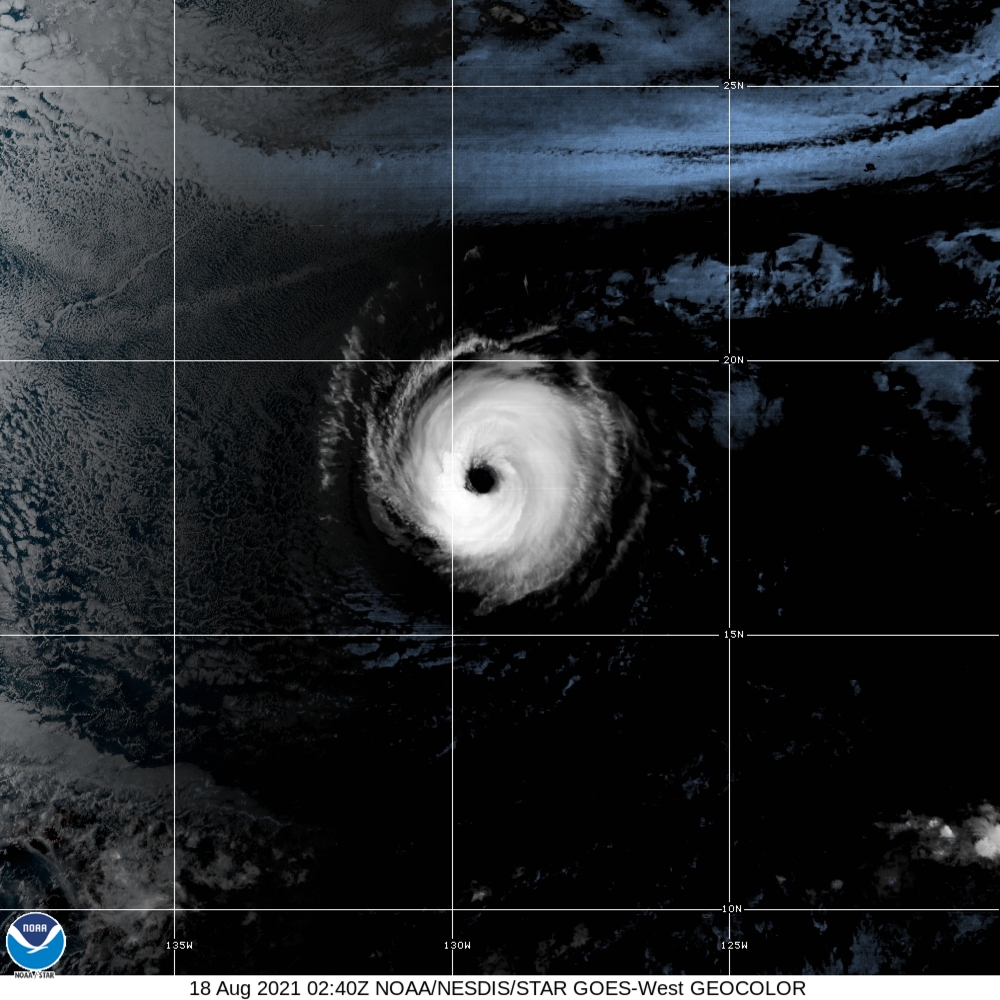
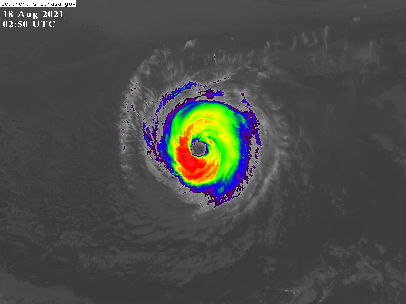
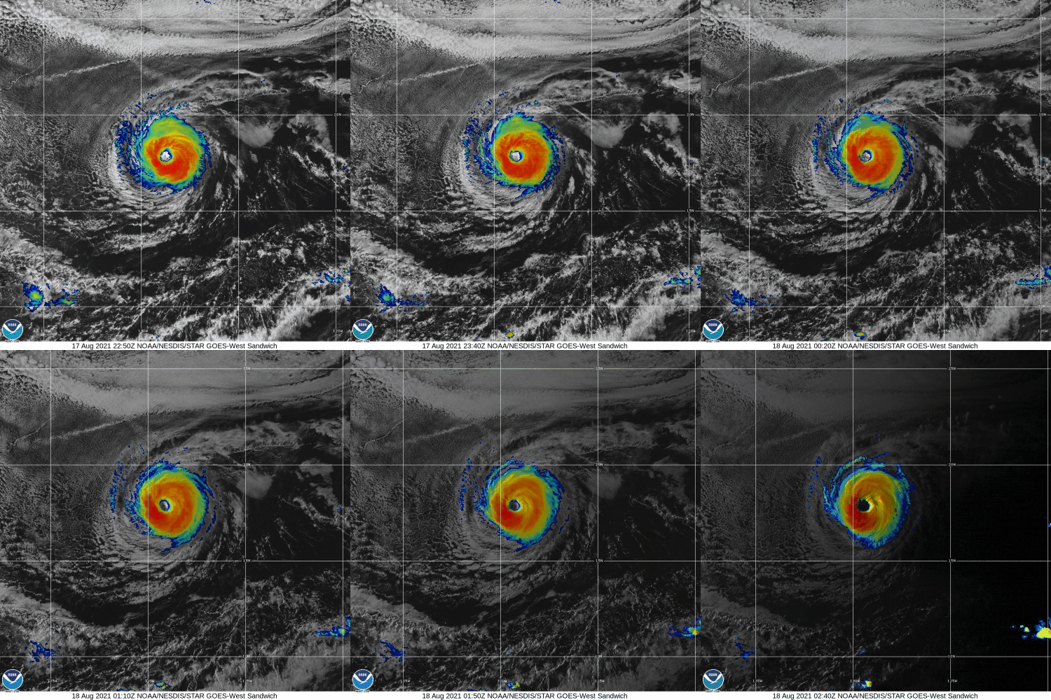
對流有所增強,重回C2(90KT) floater_floater_EP122021_Sandwich_24fr_20210817-2301.gif
20212300240_GOES17-ABI-FL-GEOCOLOR-EP122021-1000x1000.jpg GOES02502021230bnCVPm.jpg

000
WTPZ42 KNHC 180255
TCDEP2

Hurricane Linda Discussion Number  32
NWS National Hurricane Center Miami FL       EP122021
500 PM HST Tue Aug 17 2021

Linda has made a bit of a comeback over the last 6-12 hours. While
the eye continues to remain clear and warm, the eyewall convection
has been gradually cooling over the course of the day, with a
thickening ring of -60 to -65 C cloud top temperatures occasionally
surrounding the eye. This has led to an increase in the most recent
subjective Dvorak intensity estimates which at 0000 UTC were
T5.5/102 kt from SAB and T5.0/90 kt from TAFB. The latest objective
UW-CIMSS ADT estimate is up to T5.3/97 kt though the most recent
SATCON estimate was only 79 kt. Taking a blend of these data yields
an estimated intensity of 90 kt for this advisory.

Linda is starting to gain some latitude, with the estimated motion
now at 280/10 kt. The track guidance philosophy remains the same,
with a mid-level ridge well-established across the North Pacific
expected to keep Linda moving on a west-northwestward track thorough
the forecast period. Once again, the guidance has shifted a bit
faster over the forecast period, and the latest NHC track forecast
has also been nudged a little faster. Based on the latest forecast,
Linda should be crossing into the Central Pacific in about 48 hours,
and is expected to pass by to the north of the Hawaiian Islands as a
post-tropical gale late in the weekend.

Linda's recent increase in intensity could be related to the cyclone
moving over a small finger of warmer sea-surface temperatures (SSTs)
currently. The storm has continued to maintain its stable annular
structure, and little change in strength is expected during the next
12 h. However, SSTs will soon begin to decrease once again and
should drop below 25 C beyond 24 hours. While the deep-layer
vertical wind shear diagnosed by SHIPS is expected to remain low for
the next 72 hours, a bit more westerly mid-level shear could begin
to undercut the outflow layer in 24-36 hours. For these reasons,
Linda should begin a more pronounced weakening trend after 24 hours,
with the tropical cyclone forecast to finally drop below hurricane
intensity Thursday Night. The latest NHC intensity forecast remains
on the high side of the guidance for the first 24 hours, but then is
brought down to the guidance mean afterwards, in best agreement with
the HFIP Corrected Consensus Approach (HCCA) guidance. While SSTs do
begin to increase again after 72 hours, an increase in southwesterly
shear is expected to prevent organized convection from redeveloping
near the center, and Linda is forecast to become a post-tropical
gale by that time.


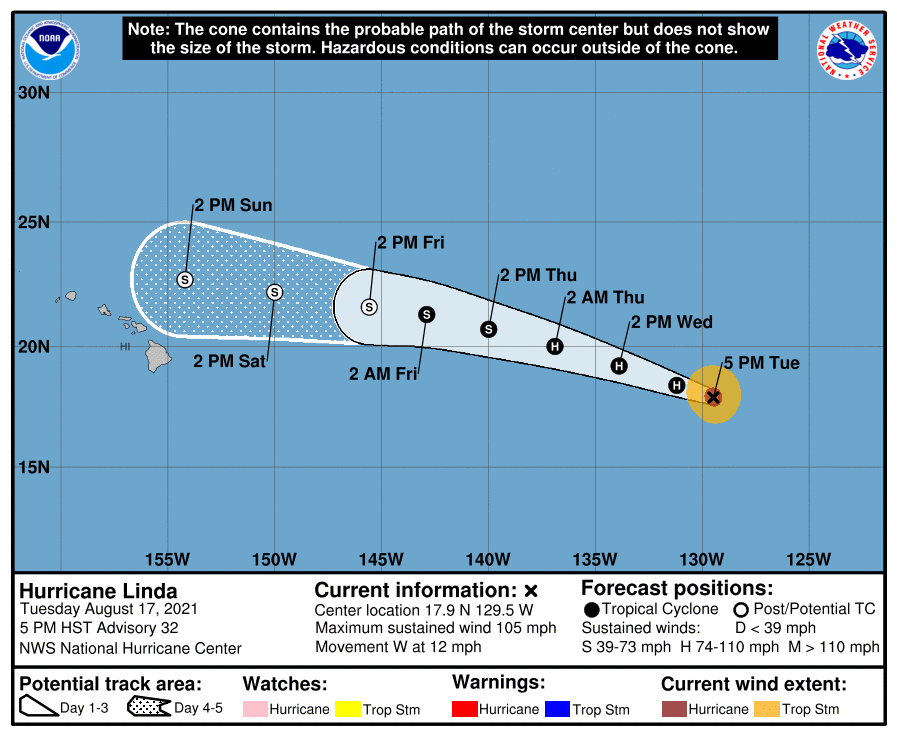
FORECAST POSITIONS AND MAX WINDS

INIT  18/0300Z 17.9N 129.5W   90 KT 105 MPH
12H  18/1200Z 18.4N 131.2W   90 KT 105 MPH
24H  19/0000Z 19.2N 133.9W   80 KT  90 MPH
36H  19/1200Z 20.0N 136.9W   70 KT  80 MPH
48H  20/0000Z 20.7N 140.0W   60 KT  70 MPH
60H  20/1200Z 21.3N 142.9W   50 KT  60 MPH
72H  21/0000Z 21.6N 145.6W   40 KT  45 MPH...POST-TROPICAL
96H  22/0000Z 22.2N 150.0W   35 KT  40 MPH...POST-TROPICAL
120H  23/0000Z 22.7N 154.2W   35 KT  40 MPH...POST-TROPICAL

$$
Forecaster Papin/Brown
025033_5day_cone_no_line_and_wind.png
回復

使用道具 舉報

簽到天數: 1650 天

[LV.Master]伴壇終老

老農民版夜神月|2021-8-18 04:42 | 顯示全部樓層
持續減弱至C1,80KT
NHC新報看好其能成為本年度第一個進入CPHC轄區仍未成為殘餘低氣壓的TC
雖然還是要看CPHC想不想負責就是了XDD
203635_5day_cone_no_line_and_wind.png floater_floater_EP122021_GEOCOLOR_24fr_20210817-1641.gif

GOES201020212298qnFEp.jpg floater_floater_EP122021_Sandwich_24fr_20210817-1639.gif
回復

使用道具 舉報

簽到天數: 1650 天

[LV.Master]伴壇終老

老農民版夜神月|2021-8-17 05:26 | 顯示全部樓層
NHC新報將定強降至85KT,並預測其將亡於踏入CPHC轄區那一刻 204809_5day_cone_no_line_and_wind.png GOES21102021228jDRhyu.jpg

FORECAST POSITIONS AND MAX WINDS

INIT  16/2100Z 17.7N 124.6W   85 KT 100 MPH
12H  17/0600Z 17.6N 125.9W   85 KT 100 MPH
24H  17/1800Z 17.7N 127.7W   85 KT 100 MPH
36H  18/0600Z 18.2N 129.8W   85 KT 100 MPH
48H  18/1800Z 19.0N 132.2W   75 KT  85 MPH
60H  19/0600Z 19.9N 134.8W   60 KT  70 MPH
72H  19/1800Z 20.7N 137.5W   50 KT  60 MPH
96H  20/1800Z 22.0N 142.6W   40 KT  45 MPH...POST-TROPICAL
120H  21/1800Z 23.0N 146.8W   35 KT  40 MPH...POST-TROPICAL


回復

使用道具 舉報

簽到天數: 1650 天

[LV.Master]伴壇終老

老農民版夜神月|2021-8-16 08:32 | 顯示全部樓層
NHC降格C2,將持續減弱
000
WTPZ42 KNHC 152032
TCDEP2

Hurricane Linda Discussion Number  23
NWS National Hurricane Center Miami FL       EP122021
1100 AM HST Sun Aug 15 2021

Linda now has the classic truck tire or doughnut appearance of an
annular hurricane in infrared satellite imagery.  The large eye is
about 35 n mi in diameter, and the surrounding cold cloud tops are
uniformly 70-90 n mi thick in all quadrants.  The initial intensity
is lowered slightly to 95 kt based on Dvorak estimates of T5.0/90 kt
from TAFB and T5.5/102 kt from SAB, and this value also matches the
latest objective ADT and SATCON estimates.

Linda has almost turned toward the west-southwest with an initial
motion of 260/10 kt, a result of a strong mid-level high centered
over California and Nevada.  This feature should push Linda toward
the west-southwest during the next 24 hours, but a repositioning of
the high over the North Pacific in a few days will allow the
hurricane to turn back toward the west by 36 hours and then the
west-northwest by day 3.  The track models remain in good agreement
on this scenario.  The NHC track forecast lies near the southern
edge of the guidance envelope, leaning towards the HCCA consensus
aid, and it essentially lies right on top of the previous official
forecast.

With little to no shear expected during the next 5 days, Linda's
intensity will be driven by thermodynamic factors.  The hurricane's
west-southwestward motion has it paralleling the sea surface
temperature gradient, keeping it over waters around 26 degrees
Celsius for the next 3 days or so.  Since annular hurricanes
typically weaken only gradually with these types of environmental
conditions, the NHC intensity forecast is above the various
intensity consensus aids and leans toward the SHIPS model, which is
at the upper end of the guidance envelope.  Linda is likely to
weaken below hurricane intensity after day 3 once it moves over
much colder waters.  Although not explicitly shown here, it is
possible that Linda could lose organized deep convection and become
a post-tropical gale by day 5.


FORECAST POSITIONS AND MAX WINDS

INIT  15/2100Z 18.8N 121.2W   95 KT 110 MPH
12H  16/0600Z 18.4N 122.5W   90 KT 105 MPH
24H  16/1800Z 17.8N 124.3W   85 KT 100 MPH
36H  17/0600Z 17.6N 126.0W   80 KT  90 MPH
48H  17/1800Z 17.7N 127.7W   75 KT  85 MPH
60H  18/0600Z 18.1N 129.7W   70 KT  80 MPH
72H  18/1800Z 18.9N 132.0W   65 KT  75 MPH
96H  19/1800Z 20.7N 136.7W   55 KT  65 MPH
120H  20/1800Z 22.5N 140.9W   40 KT  45 MPH

$$
Forecaster Berg

203338_5day_cone_no_line_and_wind.png 20210816.0000.goes-16.vis.2km.12E.LINDA.95kts.969mb.18.9N.120.7W.pc.jpg
GOES00262021228YISYwc.jpg
回復

使用道具 舉報

簽到天數: 1650 天

[LV.Master]伴壇終老

老農民版夜神月|2021-8-15 00:34 | 顯示全部樓層
NHC升格C4 20212261550_GOES17-ABI-FL-GEOCOLOR-EP122021-1000x1000.jpg GOES16202021226HN1YZT.jpg
goes17_ir_12E_202108141355.gif goes17_ir-dvorak_12E_202108141355.gif

WTPZ42 KNHC 141434
TCDEP2

Hurricane Linda Discussion Number  18
NWS National Hurricane Center Miami FL       EP122021
800 AM PDT Sat Aug 14 2021

Linda is maintaining a well-defined 15-n mi wide eye, and a quite
symmetric surrounding convective cloud pattern.  Taking a blend of
the latest subjective and objective Dvorak estimates gives a current
intensity estimate of about 115 kt, i.e. category 4 strength.

Linda may undergo an eyewall replacement later today, which is
typical for intense hurricanes, and this could cause some
short-term fluctuations in intensity.  The hurricane is currently
in a low-vertical shear environment, and the dynamical guidance
indicates that the shear will remain low for the next few days.
However, SSTs beneath Linda should gradually lower along with
decreasing environmental mid-level humidities during the next
several days. Thus a slow weakening trend should commence by
tonight.  The official intensity forecast is a blend of the
corrected and simple model consensus predictions.

The initial motion is estimated to be west-northwestward, or
290/11 kt.  There is little change to the expected steering
scenario.  Linda is moving along the southern side of a pronounced
subtropical ridge.  The ridge is predicted by the global models to
build westward to the northwest of the hurricane during the next
couple of days.  This should cause Linda to turn toward the
west-southwest within the next day or two.  Late in the forecast
period, as the ridge weakens, the cyclone is forecast to turn
westward. The NHC track forecast is very close to the previous
one and in good agreement with the latest dynamical model consensus.

FORECAST POSITIONS AND MAX WINDS

INIT  14/1500Z 18.8N 116.1W  115 KT 130 MPH
12H  15/0000Z 19.1N 117.7W  110 KT 125 MPH
24H  15/1200Z 19.2N 119.8W   95 KT 110 MPH
36H  16/0000Z 19.0N 121.8W   85 KT 100 MPH
48H  16/1200Z 18.5N 123.8W   80 KT  90 MPH
60H  17/0000Z 18.0N 125.6W   75 KT  85 MPH
72H  17/1200Z 17.9N 127.5W   70 KT  80 MPH
96H  18/1200Z 18.5N 131.5W   65 KT  75 MPH
120H  19/1200Z 20.5N 136.0W   55 KT  65 MPH

$$
Forecaster Pasch

回復

使用道具 舉報

簽到天數: 1650 天

[LV.Master]伴壇終老

老農民版夜神月|2021-8-14 05:01 | 顯示全部樓層
NHC升格MH,為今年東太第二個MH 20212252030_GOES17-ABI-FL-GEOCOLOR-EP122021-1000x1000.jpg 20210813.2030.goes-16.ir.12E.LINDA.100kts.965mb.17.2N.112.3W.100pc.jpg
20210813.1417.f17.91pct91h91v.12E.LINDA.90kts.971mb.16.6N.111.2W.095pc.jpg 20210813.1417.f17.91h.12E.LINDA.90kts.971mb.16.6N.111.2W.095pc.jpg 204811_5day_cone_no_line_and_wind.png

000
WTPZ42 KNHC 132046
TCDEP2

Hurricane Linda Discussion Number  15
NWS National Hurricane Center Miami FL       EP122021
300 PM MDT Fri Aug 13 2021

Linda has become an impressive looking hurricane this afternoon. The
eye that first became evident on geostationary satellite imagery
this morning has continued to clear out and warm while the
surrounding cold convection associated with the eyewall wraps around
the eye. The convective structure on microwave imagery has also
improved, with a distinct eye and closed eyewall apparent in an
earlier 1417 UTC SSMIS pass. The 1800 UTC subjective and objective
Dvorak estimates were in unanimous agreement with T5.5/102 kt
provided by SAB, TAFB, and ADT sources. Therefore, the initial
intensity has been increased to 100 kt this advisory, making Linda a
major hurricane.

Linda continues to move steadily to the west-northwest, at 300/12
kt. The track philosophy has not changed much over the past 24
hours. A mid- to upper-level ridge currently centered over the
southwestern United States is expected to expand westward, building
in to the northwest of the hurricane. This evolution should result
in Lisa's motion bending left, first to the west, and then to the
west-southwest over the next 2-3 days. The track guidance remains
tightly clustered near and just slightly poleward of the previous
forecast track. The latest NHC track forecast was nudged just
slightly northward over the first few days, but is nearly on top of
the previous forecast by the end of the period.

Linda has rapidly intensified, with a 35-kt increase over the past
24 hours, and the hurricane still has an opportunity to intensify a
bit more over the next 12 hours. After 24 hours, Linda will begin to
cross over gradually decreasing sea-surface temperatures and into a
and drier mid-level environment. These factors should lead to
gradual weakening. One fly in the ointment is that the shear
diagnosed by SHIPS guidance is expected to remain low and easterly
while sea-surface temperatures remain between 26-27 C through 60
hours. Both the ECMWF and HWRF simulated brightness temperatures
during that time suggest that Linda could develop a stable annular
structure, which often results in a slower than expected weakening
rate. For this reason, the latest intensity forecast only shows
gradual weakening through 60 hours, which is a bit above the HCCA
consensus aid. More rapid weakening is likely at the end of the
forecast period when Linda will move over sub 25 C water.


FORECAST POSITIONS AND MAX WINDS

INIT  13/2100Z 17.5N 112.9W  100 KT 115 MPH
12H  14/0600Z 18.2N 114.6W  110 KT 125 MPH
24H  14/1800Z 18.9N 116.9W  105 KT 120 MPH
36H  15/0600Z 19.2N 119.2W  100 KT 115 MPH
48H  15/1800Z 19.1N 121.3W   95 KT 110 MPH
60H  16/0600Z 18.7N 123.3W   85 KT 100 MPH
72H  16/1800Z 18.2N 125.2W   75 KT  85 MPH
96H  17/1800Z 17.9N 129.0W   65 KT  75 MPH
120H  18/1800Z 19.0N 133.0W   55 KT  65 MPH

$$
Forecaster Papin/Brennan

回復

使用道具 舉報

快速回覆
您需要登錄後才可以回帖 登錄 | 立即加入

本版積分規則

本平台僅供學術討論之用,預報應以氣象局為準

威普網站虛擬主機贊助公司

臺灣第一個天氣類型社群平台 即時天氣資訊、精準颱風動態

線上客服
FB傳送訊息
廣告行銷
精準行銷 物超所值
官方粉專
發佈 快速回復 返回頂部 返回列表