開啟輔助訪問
 找回密碼
 立即加入

12E.Linda 發展超乎預期 巔峰達C4 西行進入中太

簽到天數: 3280 天

[LV.Master]伴壇終老

t02436|2021-8-14 00:15 | 顯示全部樓層
底層風眼建立完成,15Z提升評價至90節,坐C2望C3。
000
WTPZ42 KNHC 131444
TCDEP2

Hurricane Linda Discussion Number  14
NWS National Hurricane Center Miami FL       EP122021
900 AM MDT Fri Aug 13 2021

Linda's structure has continued to improve since early this morning.
An eye was evident in longwave and shortwave IR imagery from GOES-17
and GOES-15 near 1200 UTC, though it has since become obscured by
cold cloud tops associated with eyewall convection. An earlier AMSR
overpass showed evidence of a ring of shallow to moderate
convection, often associated with rapidly intensifying cyclones.
Intensity estimates at 1200 UTC ranged from 77 kt to 97 kt, so the
initial intensity was set at 90 kt, in closest agreement with the
U-W CIMSS SATCON. It is worth noting that Linda's intensity is in a
range where estimates can range greatly, so confidence in that
assessment is not particularly high.

Computational problems with the GFS this morning has limited the
guidance available for the forecast, particularly with respect to
the intensity. Therefore, despite the higher initial intensity and
recent improvement in convective structure, the official intensity
forecast was only modestly increased in the short term. It does not
appear that wind shear will be a major inhibiting factor during the
next day or two. Environmental moisture and SSTs should also be
sufficient for further strengthening. The NHC forecast is a little
above the model consensus and previous forecast for the next
24-36 h. After that time, Linda should move over cooler SSTs which
should cause at least gradual weakening. By the end of the 5-day
period, the NHC forecast is in line with the consensus and identical
to the previous advisory.

Only small tweaks were made to the NHC track forecast. Linda
continues to move toward the west-northwest with an estimated
forward speed of 11 kt. The global models unanimously forecast that
a deep-layer ridge to the north of Linda will build over the
weekend, causing the hurricane to turn westward, and then
west-southwestward by early next week. Confidence in the track
forecast is quite high due to the agreement among the track models.

FORECAST POSITIONS AND MAX WINDS

INIT  13/1500Z 16.9N 111.8W   90 KT 105 MPH
12H  14/0000Z 17.6N 113.6W  100 KT 115 MPH
24H  14/1200Z 18.4N 115.9W  105 KT 120 MPH
36H  15/0000Z 18.8N 118.2W  105 KT 120 MPH
48H  15/1200Z 18.8N 120.3W  100 KT 115 MPH
60H  16/0000Z 18.6N 122.3W   90 KT 105 MPH
72H  16/1200Z 18.2N 124.2W   80 KT  90 MPH
96H  17/1200Z 17.5N 128.0W   65 KT  75 MPH
120H  18/1200Z 18.5N 132.0W   60 KT  70 MPH

$$
Forecaster Zelinsky

144305_5day_cone_with_line.png

20210813.1417.f17.91pct91h91v.12E.LINDA.90kts.971mb.16.6N.111.2W.095pc.jpg

goes17_truecolor_12E_202108131335.gif

GOES160020212256KH6M8.jpg
回復

使用道具 舉報

簽到天數: 1650 天

[LV.Master]伴壇終老

老農民版夜神月|2021-8-13 01:02 | 顯示全部樓層
本帖最後由 老農民版夜神月 於 2021-8-13 03:38 編輯

NHC升格C1
000
WTPZ42 KNHC 121450
TCDEP2

Hurricane Linda Discussion Number  10
NWS National Hurricane Center Miami FL       EP122021
900 AM MDT Thu Aug 12 2021

Linda has been trying to form an eye in conventional satellite
imagery during the past few hours, but that feature has been
obscured by the development of new convective bursts near the
center.  An AMSR2 microwave pass from 0850 UTC indicated that the
structure remains well organized, if not a little tilted with
height due to shear, and a ragged mid-level eye feature was noted.  
Objective intensity estimates are at hurricane strength--T4.4/75 kt
from the UW-CIMSS ADT and 66 kt from SATCON--but subjective CI
numbers from TAFB and SAB remain at 3.5/55 kt.  Given the continued
attempts at eye formation, I have elected to lean on the side of the
objective numbers and increase the initial intensity to 65 kt,
making Linda a hurricane.

The AMSR2 pass revealed that Linda has been moving a little to the
right of the previous forecast track, and the initial motion is
estimated to be west-northwestward, or 300/7 kt.  Mid-tropospheric
ridging located over northern Mexico should keep Linda on a
west-northwestward track for the next 2 to 3 days.  After that
time, another ridge is forecast to slide westward from California
out over the Pacific, which should have a blocking influence on
Linda and cause it to turn back toward the west.  In fact, by day 5,
most of the track models are showing a south-of-due-west motion.
On the whole, the guidance is showing a normal amount of spread, and
the NHC track forecast has only been shifted slightly eastward and
northward through day 3 to account for the adjustment of the initial
position.  This solution is very close to the HCCA and TVCE
consensus aids.

Moderate northerly to north-northeasterly shear continues to affect
the cyclone, and the effect of this shear was seen in the slight
offset of the low- and mid-level centers in microwave imagery.  The
shear is forecast to subside slightly during the next couple of
days while the hurricane moves over warm waters of 28-29 degrees
Celsius and within an environment of upper-level divergence.  The
limiting effects of the shear are likely to support gradual
strengthening during the next couple of days, and the NHC intensity
forecast is within the relatively tightly packed guidance suite
during that time.  During the 3-5 day period, shear is expected to
decrease substantially, but less conducive thermodynamic conditions
should cause Linda to gradually lose intensity, potentially
weakening to a tropical storm by day 5.

FORECAST POSITIONS AND MAX WINDS

INIT  12/1500Z 14.8N 107.7W   65 KT  75 MPH
12H  13/0000Z 15.6N 109.1W   65 KT  75 MPH
24H  13/1200Z 16.6N 111.2W   70 KT  80 MPH
36H  14/0000Z 17.7N 113.4W   75 KT  85 MPH
48H  14/1200Z 18.6N 115.5W   80 KT  90 MPH
60H  15/0000Z 19.2N 117.6W   80 KT  90 MPH
72H  15/1200Z 19.4N 119.6W   75 KT  85 MPH
96H  16/1200Z 19.1N 123.4W   65 KT  75 MPH
120H  17/1200Z 19.0N 127.2W   55 KT  65 MPH

$$
Forecaster Berg

145202_5day_cone_no_line_and_wind.png 20210812.1500.goes-16.vis.2km.12E.LINDA.60kts.993mb.14.6N.107.3W.pc.jpg 20210812.1619.mtc.ASCAT.wind.12E.LINDA.60kts-993mb.146N.1073W.25km.noqc.jpeg GOES19202021224ZdDwE0.jpg
回復

使用道具 舉報

簽到天數: 1650 天

[LV.Master]伴壇終老

老農民版夜神月|2021-8-12 04:56 | 顯示全部樓層
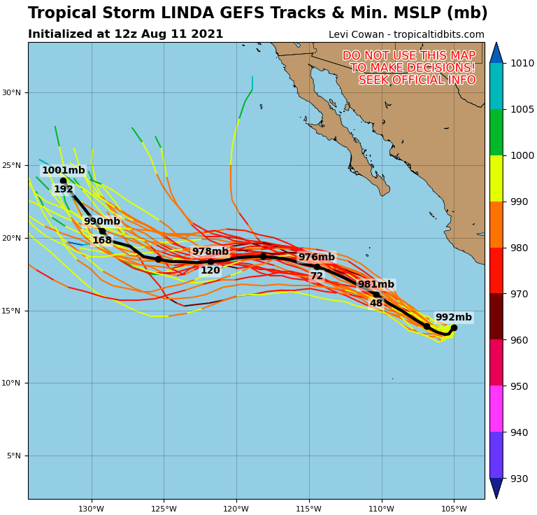
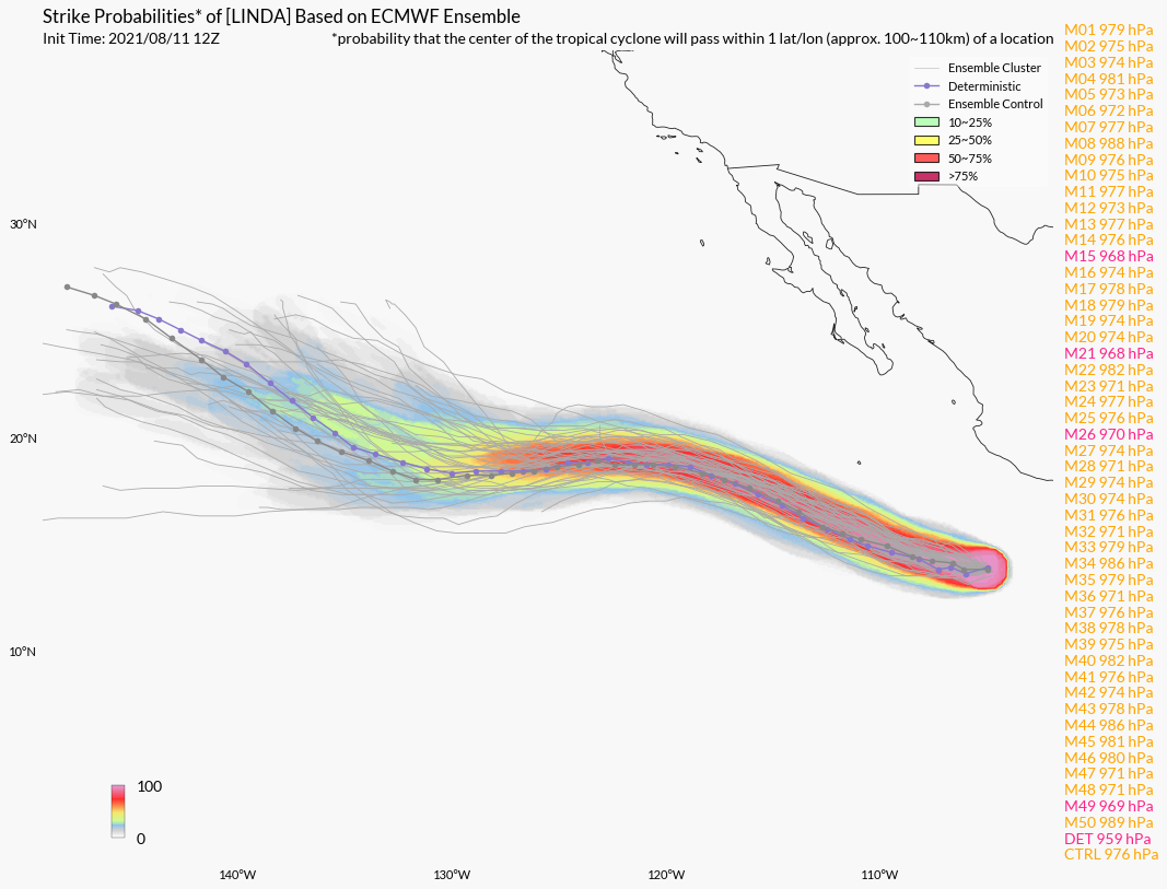
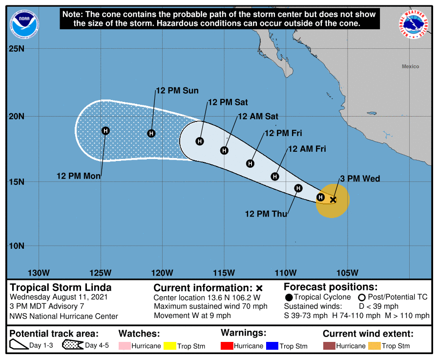
NHC將定強調至TS上限,即將升格C1.並持續上調上望至90節 20212232010_GOES17-ABI-FL-GEOCOLOR-EP122021-1000x1000.jpg
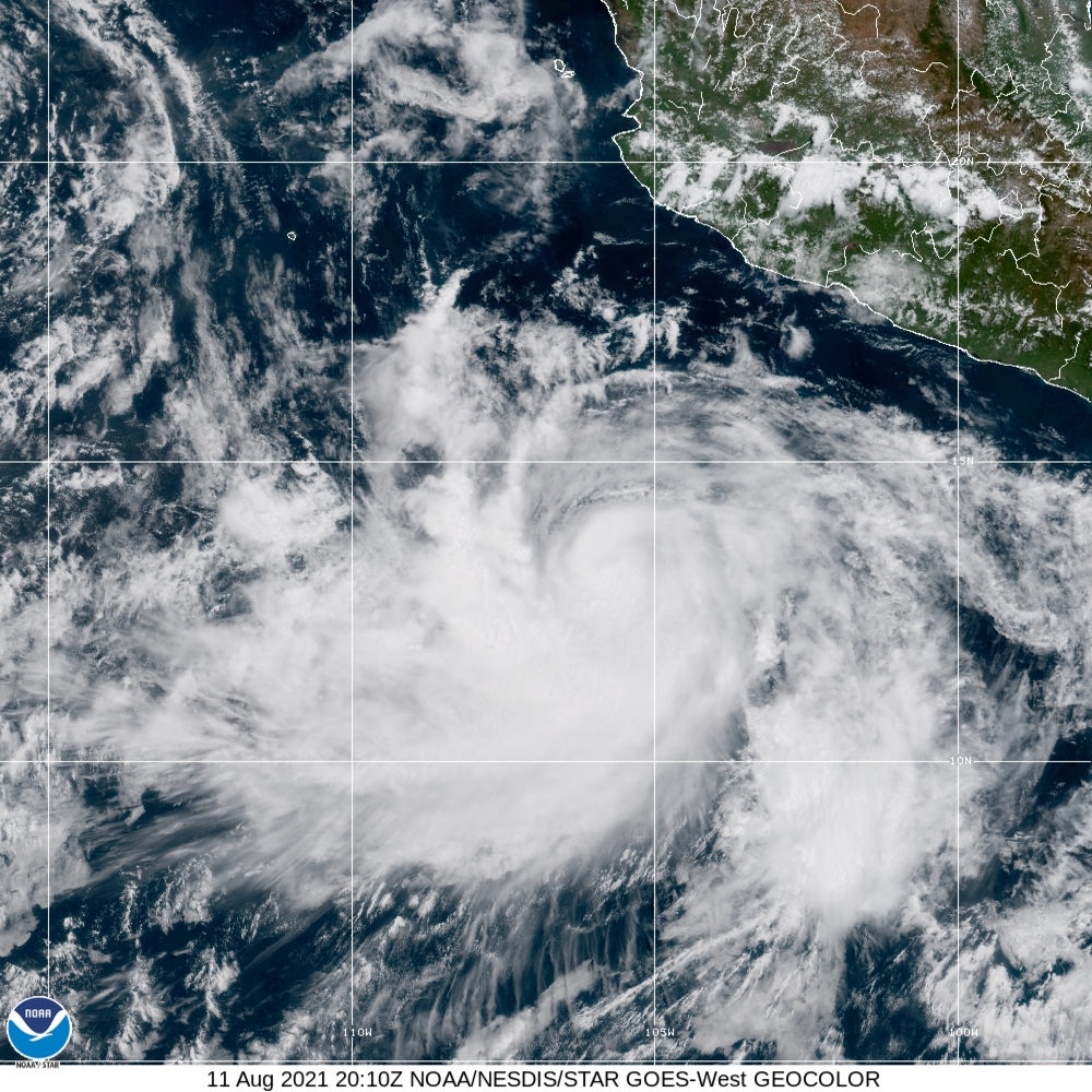
12E_gefs_latest.png LINDA.png
204141_5day_cone_no_line_and_wind.png

000
WTPZ42 KNHC 112041
TCDEP2

Tropical Storm Linda Discussion Number   7
NWS National Hurricane Center Miami FL       EP122021
300 PM MDT Wed Aug 11 2021

After the issuance of the previous advisory, Linda showed hints of
an eye in visible and infrared satellite imagery.  That feature
is no longer apparent, and it appears that some dry air has
infiltrated into the circulation.  That being said, earlier
microwave data indicated that the storm has a robust structure, and
new convection is developing near the center.  The latest Dvorak
T-numbers are T3.5 from TAFB and T4.0 from SAB, and as a result,
the initial intensity is raised to 60 kt.

Linda has been losing latitude for the past 12-18 hours, and the
initial motion is south of due west, or 260/8 kt.  The mid-level
ridge that is steering Linda extends over northern Mexico, reaching
as far as the Baja California peninsula.  With Linda approaching
the western edge of the ridge, it should begin to gain latitude
again soon and turn toward the west-northwest by 24 hours.  General
ridging should remain in control through the 5-day forecast period,
maintaining Linda on a west-northwestward or westward track with
minimal changes in speed.  There were no noteworthy changes to the
guidance on this cycle, and the updated NHC track forecast is very
close to the HCCA consensus aid and not too different from the
previous forecast.

As mentioned earlier today, the environment ahead of Linda consists
of a mix of positives and negatives for intensification.  
North-northeasterly shear of 15-20 kt is not expected to decrease
much in the coming days, which could allow some dry air to continue
penetrating into the circulation.  On the other hand, Linda's track
will keep it over warm 28 degree Celsius waters for several days,
and strong upper-level divergence should support deep convective
development for another couple of days.  Therefore, steady
strengthening is shown in the official forecast, which indicates a
slightly higher peak intensity compared to this morning's forecast.
An important note is that several dynamical and statistical models
are showing the intensity peaking near or at major hurricane
intensity in 2 to 3 days.  However, given the presence of the shear,
I'd prefer to keep the forecast on the conservative side and only
nudge the forecast up for now.  Future upward adjustments may
be required if Linda strengthens more in the short term than what is
shown in the official forecast.  Weakening should occur by days 4
and 5 due to Linda moving over cooler waters.


FORECAST POSITIONS AND MAX WINDS

INIT  11/2100Z 13.6N 106.2W   60 KT  70 MPH
12H  12/0600Z 13.8N 107.2W   70 KT  80 MPH
24H  12/1800Z 14.5N 109.0W   80 KT  90 MPH
36H  13/0600Z 15.4N 110.9W   85 KT 100 MPH
48H  13/1800Z 16.4N 112.9W   90 KT 105 MPH
60H  14/0600Z 17.4N 115.0W   90 KT 105 MPH
72H  14/1800Z 18.1N 117.0W   90 KT 105 MPH
96H  15/1800Z 18.7N 120.9W   80 KT  90 MPH
120H  16/1800Z 18.9N 124.6W   65 KT  75 MPH

$$
Forecaster Berg

回復

使用道具 舉報

簽到天數: 1650 天

[LV.Master]伴壇終老

老農民版夜神月|2021-8-11 05:44 | 顯示全部樓層
NHC升格TS,並命名Linda,略微上調上望至C2,85KT 204727_5day_cone_no_line_and_wind.png 20212222100_GOES16-ABI-FL-GEOCOLOR-EP122021-1000x1000.jpg
GOES21302021222JrSWeV.jpg

000
WTPZ42 KNHC 102049
TCDEP2

Tropical Storm Linda Discussion Number   3
NWS National Hurricane Center Miami FL       EP122021
400 PM CDT Tue Aug 10 2021

A recent ASCAT-B overpass revealed tropical-storm-force winds in
both the northern and southern semicircles of the cyclone, with
believable peak winds of 38 kt. Therefore, the depression has been
upgraded to a 40-kt tropical storm.

Moderate to strong northerly shear over Linda is keeping the bulk of
the deep convection confined to the southern portion of the
cyclone's circulation, resulting in a partially exposed low-level
center. This shear is forecast to persist over the storm for the
next day or so. Therefore, despite a moist, unstable environment
with ample oceanic heat content, only slow strengthening is expected
in the short term. If the shear decreases as anticipated, a
faster rate of intensification should occur for a couple of days.
The latest NHC intensity forecast is on the low end of the guidance
through 24-36 h due to the anticipated affects of the shear, and
then trends to near the various intensity consensus values
thereafter.

The estimated motion of Linda remains 295/9 kt. The cyclone is
expected to turn westward tonight as a ridge builds to its north,
and then resume a west-northwestward motion by later this week as it
begins to move along the southwestern periphery of this ridge. This
track is roughly parallel to, but well offshore of, the southwestern
coast of Mexico over the next couple of days. Thereafter, the
depression is forecast to move away from the coast of Mexico. The
latest NHC forecast track is little changed from the previous one,
and lies near the consensus track guidance.


FORECAST POSITIONS AND MAX WINDS

INIT  10/2100Z 14.4N 102.8W   40 KT  45 MPH
12H  11/0600Z 14.8N 104.0W   45 KT  50 MPH
24H  11/1800Z 15.0N 105.6W   50 KT  60 MPH
36H  12/0600Z 15.3N 106.9W   60 KT  70 MPH
48H  12/1800Z 16.0N 108.3W   70 KT  80 MPH
60H  13/0600Z 16.9N 110.0W   80 KT  90 MPH
72H  13/1800Z 17.8N 112.0W   85 KT 100 MPH
96H  14/1800Z 19.3N 116.0W   85 KT 100 MPH
120H  15/1800Z 20.0N 120.0W   75 KT  85 MPH

$$
Forecaster Latto
12E_intensity_latest.png
回復

使用道具 舉報

簽到天數: 76 天

[LV.6]常住居民II

Heigo|2021-8-10 17:14 | 顯示全部樓層
本帖最後由 Heigo 於 2021-8-10 17:19 編輯

NHC升格TD12E,首報上望80節
000
WTPZ42 KNHC 100843
TCDEP2

Tropical Depression Twelve-E Discussion Number   1
NWS National Hurricane Center Miami FL       EP122021
400 AM CDT Tue Aug 10 2021

Over the past several hours, showers and thunderstorms have showed
increased signs of organization in association with an area of low
pressure located a few hundred miles south of Acapulco, Mexico. An
ASCAT-B pass around 0330 UTC revealed that the low has developed a
well-defined center and is producing 25 to 30-kt winds, with some
higher wind vectors flagged as rain contaminated within the deep
convection occurring to the south and west of the center. The system
has become sufficiently organized to be classified as a tropical
depression, and its initial intensity is set at 30 kt for this
advisory.

The estimated motion of the depression is west-northwest, or
290/7 kt. The system is expected to generally move
west-northwestward to westward over the next several days, as it is
steered by a ridge to its north and northeast. This track is roughly
parallel to, but well offshore of, the southwestern coast of
Mexico. The track guidance is in reasonably good agreement, and the
official NHC forecast lies near the center of the guidance envelope.

The depression is located in a moist, unstable environment with
ample oceanic heat content to fuel strengthening during the next few
days. However, moderate to strong northerly vertical wind shear will
likely prevent rapid intensification of this system in the short
term. Nonetheless, the intensity guidance unanimously supports
strengthening, and this system is likely to become a tropical storm
later today. Continued strengthening is forecast through the rest of
the week and into the weekend, and the cyclone could reach hurricane
strength by Thursday. The official NHC intensity forecast generally
follows the IVCN consensus aid and shows the system's intensity
peaking on days 4 and 5, when the wind shear is forecast to
diminish while the cyclone remains over warm SSTs.


FORECAST POSITIONS AND MAX WINDS

INIT  10/0900Z 13.0N 100.8W   30 KT  35 MPH
12H  10/1800Z 13.7N 102.0W   40 KT  45 MPH
24H  11/0600Z 14.3N 103.6W   45 KT  50 MPH
36H  11/1800Z 14.5N 105.3W   50 KT  60 MPH
48H  12/0600Z 14.7N 106.5W   60 KT  70 MPH
60H  12/1800Z 15.3N 107.9W   65 KT  75 MPH
72H  13/0600Z 16.3N 109.4W   70 KT  80 MPH
96H  14/0600Z 18.2N 113.3W   80 KT  90 MPH
120H  15/0600Z 19.0N 117.5W   80 KT  90 MPH

$$
Forecaster Reinhart/Pasch
084520_5day_cone_no_line_and_wind.png
回復

使用道具 舉報

簽到天數: 1650 天

[LV.Master]伴壇終老

老農民版夜神月|2021-8-10 07:00 | 顯示全部樓層
數值看好後期強度,有望成為今年東太第2個MH
93E_gefs_latest (1).png 93E_intensity_latest.png
gfs_mslp_pcpn_epac_21.png ecmwf_mslp_uv850_epac_6.png
回復

使用道具 舉報

簽到天數: 1650 天

[LV.Master]伴壇終老

老農民版夜神月|2021-8-9 14:30 | 顯示全部樓層
NHC展望提升至High,70%/90%
1. A broad area of low pressure located a few hundred miles south of
the Gulf of Tehuantepec continues to produce disorganized showers
and a few thunderstorms.  Environmental conditions are conducive for
development of this disturbance, and a tropical depression is
expected to form within the next couple of days.  This system is
forecast to move westward to west-northwestward at about 10 mph
through midweek, parallel to and offshore of the coast of southern
Mexico.
* Formation chance through 48 hours...high...70 percent.
* Formation chance through 5 days...high...90 percent.

two_pac_2d1 (8).png two_pac_5d1 (8).png 93E_intensity_latest.png
回復

使用道具 舉報

簽到天數: 1650 天

[LV.Master]伴壇終老

老農民版夜神月|2021-8-9 09:01 | 顯示全部樓層
JTWC發布TCFA
WTPN21 PHNC 090000
MSGID/GENADMIN/JOINT TYPHOON WRNCEN PEARL HARBOR HI//
SUBJ/TROPICAL CYCLONE FORMATION ALERT (INVEST 93E)//
RMKS/
1. FORMATION OF A SIGNIFICANT TROPICAL CYCLONE IS POSSIBLE WITHIN
120 NM EITHER SIDE OF A LINE FROM 10.9N 95.2W TO 12.9N 101.4W
WITHIN THE NEXT 12 TO 24 HOURS. AVAILABLE DATA DOES NOT JUSTIFY
ISSUANCE OF NUMBERED TROPICAL CYCLONE WARNINGS AT THIS TIME.
WINDS IN THE AREA ARE ESTIMATED TO BE 15 TO 20 KNOTS. METSAT
IMAGERY AT 090000Z INDICATES THAT A CIRCULATION CENTER IS LOCATED
NEAR 11.0N 95.5W. THE SYSTEM IS MOVING WEST-NORTHWESTWARD AT 12
KNOTS.
2. REMARKS: AN AREA OF CONVECTION (93E) HAS PERSISTED NEAR 11.0N
95.5W APPROXIMATELY 300 NM SOUTH SOUTHEAST OF PUNTA ESCONDITA,
MEXICO. ANIMATED MULTISPECTRAL SATELLITE IMAGERY (MSI) DEPICTS AN
AREA OF FLARING CONVECTION AND BROAD TURNING AROUND AN ILL-DEFINED
LOW LEVEL CIRCULATION (LLC). A 082257Z SSMIS 91GHZ SATELLITE IMAGE
REVEALS AREAS OF DEEP CONVECTION WITHOUT A CLEAR LLC. ANALYSES
INDICATE AN OVERALL FAVORABLE ENVIRONMENT FOR DEVELOPMENT
CHARACTERIZED BY EQUATORWARD OUTFLOW ALOFT, LOW TO MODERATE (10-20
KT) VERTICAL WIND SHEAR (VWS), AND WARM (29-30C) SEA SURFACE
TEMPERATURES. GLOBAL MODELS GENERALLY AGREE THAT INVEST 93E WILL
CONSOLDATE AND STRENGTHEN AS IT PROPAGATES NORTHWESTWARD. MAXIMUM
SUSTAINED SURFACE WINDS ARE ESTIMATED AT 15 TO 20 KNOTS. MINIMUM SEA
LEVEL PRESSURE IS ESTIMATED TO BE NEAR 1007 MB. THE POTENTIAL FOR
THE DEVELOPMENT OF A SIGNIFICANT TROPICAL CYCLONE WITHIN THE NEXT 24
HOURS IS HIGH.
3. THIS ALERT WILL BE REISSUED, UPGRADED TO WARNING OR CANCELLED BY
100000Z.//
NNNN
ep9321.gif 93E_090000sair.jpg
回復

使用道具 舉報

快速回覆
您需要登錄後才可以回帖 登錄 | 立即加入

本版積分規則

本平台僅供學術討論之用,預報應以氣象局為準

威普網站虛擬主機贊助公司

臺灣第一個天氣類型社群平台 即時天氣資訊、精準颱風動態

線上客服
FB傳送訊息
廣告行銷
精準行銷 物超所值
官方粉專
發佈 快速回復 返回頂部 返回列表