開啟輔助訪問
 找回密碼
 立即加入

07L.Grace 巔峰曾達C3 登陸墨西哥 進入東太

簽到天數: 1650 天

[LV.Master]伴壇終老

老農民版夜神月|2021-8-17 05:16 | 顯示全部樓層
NHC新報較為看好後期發展,預測有望於登陸墨西哥前至少達到C1強度 205353_5day_cone_no_line_and_wind.png 07L_intensity_latest (1).png

ZCZC MIATCDAT2 ALL
TTAA00 KNHC DDHHMM

Tropical Depression Grace Discussion Number  14
NWS National Hurricane Center Miami FL       AL072021
500 PM EDT Mon Aug 16 2021

Grace may have regained tropical storm status just before the
center moved across the Barahona Peninsula of the Dominican
Republic around midday.  The Air Force Reserve Hurricane Hunters
measured peak 925-mb winds of 45 kt very near the coast, which
would equate to an intensity right at the threshold of tropical
storm.  Since then, however, land interaction has likely weakened
these winds, and Grace is still estimated to be a 30-kt depression.
The center appears to have moved back over water just to the south
of the Haitian coast.

Grace has been moving a little slower today, possibly due to
interaction with the terrain of Hispaniola, and the initial motion
is estimated to be 285/11 kt.  A mid-level high centered over the
western Atlantic is forecast to build westward over the
southeastern United States and northern Gulf of Mexico in the
coming days.  This pattern should keep Grace on a westward to
west-northwestward trajectory for the entire 5-day forecast period,
moving across the northwestern Caribbean Sea, across the northern
Yucatan Peninsula, and into the southwestern Gulf of Mexico.  The
most significant model trends are on days 4 and 5, when many of the
track models are indicating a slight west-southwest bend as the
cyclone approaches mainland Mexico.  The NHC track forecast has
been nudged southward at most forecast times, but that may be
within the noise level of typical model run-to-run variability.

Once the center of Grace moves away from Hispaniola tomorrow, the
deep, warm waters of the northwestern Caribbean Sea and relatively
light deep-layer shear should be conducive for strengthening.
Model data suggest that some mid-level shear could come into play
at times, so it's not a sure bet that conditions will be ideal for
significant strengthening.  Partly for that reason, the NHC
intensity forecast is near or just below the intensity consensus.
However, even this new forecast is a little higher than the
previous forecast, and many of the models indicate that Grace could
be near or at hurricane strength when it approaches the Yucatan
Peninsula in about 60 hours.  After passing the Yucatan Peninsula,
additional strengthening is likely, and the new forecast now
explicitly shows Grace reaching hurricane intensity over the
southwestern Gulf of Mexico.


Key Messages:

1. Heavy rainfall across the Dominican Republic, Haiti, Cuba,
Jamaica, and the Cayman Islands may lead to flash, urban, and small
stream flooding, with the potential for mudslides highest in Haiti
and the Dominican Republic.

2. Tropical storm conditions are possible over portions of
Hispaniola this evening and tonight, and over Jamaica on Tuesday.
Tropical storm conditions are expected over portions of the southern
coast of Cuba on Tuesday, spreading westward to the Cayman Islands
and possibly other portions of the southern coast of Cuba Tuesday
evening through Wednesday morning.

3.  There is a increasing risk of wind, rainfall, and storm surge
impacts on the Yucatan Peninsula of Mexico Wednesday night and
Thursday.  Interests there areas should monitor the progress of
Grace and updates to the forecast.


FORECAST POSITIONS AND MAX WINDS

INIT  16/2100Z 17.9N  72.4W   30 KT  35 MPH
12H  17/0600Z 18.3N  74.4W   30 KT  35 MPH...NEAR SW TIP OF HAITI
24H  17/1800Z 18.9N  77.2W   35 KT  40 MPH
36H  18/0600Z 19.6N  80.4W   40 KT  45 MPH...NEAR CAYMAN ISLANDS
48H  18/1800Z 20.2N  83.5W   50 KT  60 MPH
60H  19/0600Z 20.9N  86.7W   60 KT  70 MPH...NEAR YUCATAN COAST
72H  19/1800Z 21.6N  89.9W   60 KT  70 MPH
96H  20/1800Z 22.4N  95.1W   65 KT  75 MPH
120H  21/1800Z 22.4N  98.8W   65 KT  75 MPH...INLAND

$$
Forecaster Berg

NNNN
07L_gefs_latest (1).png GRACE.png
回復

使用道具 舉報

簽到天數: 1650 天

[LV.Master]伴壇終老

老農民版夜神月|2021-8-16 08:36 | 顯示全部樓層
NHC將其暫時降格為TD,並預估直到穿越古巴後才回重新增強為TS 234910_5day_cone_no_line_and_wind.png 20210816.0000.goes-16.ir.07L.GRACE.30kts.1011mb.17.1N.68.1W.100pc.jpg
GOES00202021228jdfIlw.jpg
000
WTNT42 KNHC 152051
TCDAT2

Tropical Depression Grace Discussion Number  10
NWS National Hurricane Center Miami FL       AL072021
500 PM AST Sun Aug 15 2021

An earlier ASCAT pass over Grace suggested that the maximum winds
were 25-30 kt and this has been confirmed by observations from a
NOAA Hurricane Hunter aircraft.  Aircraft and scatterometer data
also suggest that the circulation is elongated and disorganized.
Based on these data, the system is being downgraded to a 30-kt
depression at this time.  Since the system is below storm strength
and is passing by Puerto Rico, the Tropical Storm Warnings for
Puerto Rico and the U.S. Virgin Islands have been discontinued.  The
island of Hispaniola is kept under a Tropical Storm Watch given the
possibility that the system could restrengthen tonight or tomorrow
morning before moving over land. Most of the reliable guidance
shows little change in strength over the next 2-3 days.  This seems
reasonable since the circulation will be interacting with the
mountainous land mass of Hispaniola and Cuba for the next 72 hours.  
The official intensity forecast is near or a little above the DSHIPS
and LGEM guidance during that time.  Some restrengthening is
possible later in the forecast period when the system is expected to
move over the Gulf of Mexico. However, the global models are not
very bullish on intensification in 4-5 days, perhaps due to drier
air.

The system has moved mainly westward today, but the track models
are generally in agreement on a west-northwestward motion over the
forecast period.  This is consistent with a well-defined mid-level
ridge staying in place over the southwestern Atlantic and across
Florida during this week.  The official track forecast has been
shifted a little south of the previous one, following the
multi-model consensus.  

Key Messages:

1. Heavy rainfall could lead to flash and urban flooding over the
Virgin Islands.  Across Puerto Rico, the Dominican Republic and
Haiti, heavy rainfall may lead to flash, urban and small stream
flooding, along with the potential for mudslides.

2. Tropical storm conditions are possible over portions of
Hispaniola Monday and Monday night.

3. There is a risk of some wind and rainfall impacts across the
Turks and Caicos Islands, the Bahamas, Cuba, and Florida, but
forecast uncertainty is much higher than usual. Interests in those
areas should monitor the progress of Grace and updates to the
forecast.

FORECAST POSITIONS AND MAX WINDS

INIT  15/2100Z 17.0N  67.3W   30 KT  35 MPH
12H  16/0600Z 17.6N  68.8W   30 KT  35 MPH
24H  16/1800Z 18.2N  71.0W   30 KT  35 MPH...INLAND
36H  17/0600Z 19.2N  73.2W   30 KT  35 MPH...OVER WATER
48H  17/1800Z 20.2N  75.8W   30 KT  35 MPH...INLAND
60H  18/0600Z 21.0N  78.7W   30 KT  35 MPH...OVER WATER
72H  18/1800Z 22.1N  81.8W   30 KT  35 MPH
96H  19/1800Z 24.0N  87.0W   35 KT  40 MPH
120H  20/1800Z 25.0N  91.0W   45 KT  50 MPH

$$
Forecaster Pasch

回復

使用道具 舉報

簽到天數: 3280 天

[LV.Master]伴壇終老

t02436|2021-8-14 20:40 | 顯示全部樓層
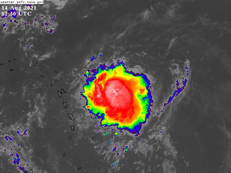
09Z報命名Grace
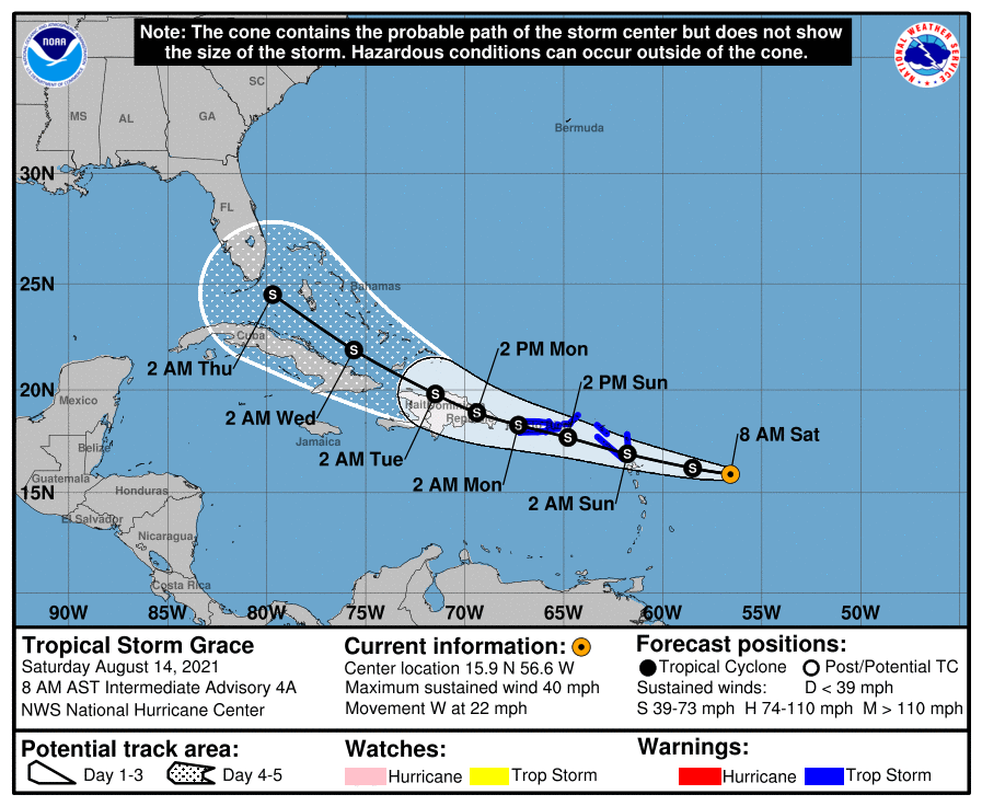
113711_5day_cone_with_line.png
000
WTNT42 KNHC 140840
TCDAT2

Tropical Storm Grace Discussion Number   4
NWS National Hurricane Center Miami FL       AL072021
500 AM AST Sat Aug 14 2021

The cyclone has become a little better organized overnight, with an
area of concentrated convection persisting over the center for the
past several hours. The system remains compact, with the convective
canopy about 100 n mi in diameter, while earlier ASCAT data revealed
winds greater than 25 kt extended only about 30 n mi from its
center, with peak winds of 27 kt. Despite the weaker maximum winds
sampled earlier this evening, the increase in organization of such
a small system has likely produced a notable increase in the
surface winds near the center. In addition the latest Dvorak
intensity estimates from TAFB, SAB, and the UW-CIMSS ADT and SATCON
suggest that the intensity is now somewhere between 30 and 45 kt.
Based on a conservative blend of these values, it is estimated that
the Tropical Depression Seven has strengthened into 35-kt Tropical
Storm Grace.

Grace continues to move quickly westward, with an initial motion of
280/19 kt. A strong mid-level ridge to the north of the storm should
continue to steer it westward for the next few days. Beyond that
time, the forecast models begin to diverge in their track solutions,
as they vary in the strength of the ridge. Overall, the models have
trended toward a stronger, more persistent ridge to the north of
the cyclone for the latter half of the forecast period, and as such
the model solutions are generally showing a track that lies a bit
south of the previous runs for those time periods. The official NHC
forecast track is little changed through 72 h and lies near the
middle of the tightly clustered track guidance. Beyond 72 h, the
forecast track has been shifted slightly to the south, but still
lies to north of the consensus model tracks.

The earlier bout of wind shear that had entrained surrounding dry
air into Grace appears to have abated, at least in the short term.
And, global models indicate that the shear will remain low for about
the next 24-36 h while the cyclone moves over increasing SSTs.
Therefore, it is reasonable to assume that strengthening should
occur over the next day or so. Thereafter, the intensity forecast
becomes somewhat complicated as the system is forecast to interact
with an upper-level trough while possibly crossing the Greater
Antilles at the same time. Slight weakening is indicated in the NHC
intensity forecast as the system crosses the northern portion of the
Dominican Republic early next week. Thereafter, moderate to strong
northerly shear is forecast to impact Grace as the system moves into
the flow on the western side of an upper-level trough over the
western Atlantic. This shear should prevent any further
strengthening through the end of the forecast period. The intensity
forecast is a little lower than a blend of the NOAA HCCA and IVCN
consensus, as there is likely a high bias from the HWRF in these
solutions. The latter portion of the NHC intensity forecast is of
lower-than-normal confidence due to the potential for a longer
amount of time over the rugged terrain of the Greater Antilles than
indicated, and also due to the fragile nature of the small cyclone
and the possible effects of the stronger shear later in the
forecast period.


Key Messages:

1.  Tropical storm conditions are expected in portions of the
Leeward Islands by tonight or early Sunday, and the U.S. Virgin
Islands and Puerto Rico on Sunday. Tropical storm conditions are
also possible over the British Virgin Islands on Sunday. The risk of
strong winds will then spread westward to the Dominican Republic
Sunday night and Monday.

2.  Heavy rainfall could lead to flash and urban flooding over the
Leeward and Virgin Islands. Across Puerto Rico, heavy rainfall may
lead to flash, urban and small stream flooding, along with the
potential for mudslides.

3.  There is a risk of wind and rainfall impacts across Haiti, the
Turks and Caicos Islands, the southeastern Bahamas, Cuba, and
Florida next week, and interests in those areas should monitor the
progress of this system.


FORECAST POSITIONS AND MAX WINDS

INIT  14/0900Z 15.8N  55.6W   35 KT  40 MPH
12H  14/1800Z 16.2N  58.5W   35 KT  40 MPH
24H  15/0600Z 16.9N  61.8W   40 KT  45 MPH
36H  15/1800Z 17.7N  64.8W   45 KT  50 MPH
48H  16/0600Z 18.3N  67.3W   45 KT  50 MPH
60H  16/1800Z 18.9N  69.4W   40 KT  45 MPH...INLAND
72H  17/0600Z 19.8N  71.5W   40 KT  45 MPH...INLAND
96H  18/0600Z 21.9N  75.6W   40 KT  45 MPH...OVER WATER
120H  19/0600Z 24.5N  79.7W   40 KT  45 MPH

$$
Forecaster Latto
GOES12302021226zf14cB.jpg
回復

使用道具 舉報

簽到天數: 1650 天

[LV.Master]伴壇終老

老農民版夜神月|2021-8-14 04:58 | 顯示全部樓層
NHC正式升格TD
000
WTNT42 KNHC 132052
TCDAT2

Tropical Depression Seven Discussion Number   2
NWS National Hurricane Center Miami FL       AL072021
500 PM AST Fri Aug 13 2021

Over the past few hours, the system moved just to the north of a
buoy owned by the Woods Hole Oceanographic Institute.  The
buoy's winds backed from northwest to west to south, indicating
that the system has a closed surface circulation.  In addition,
Dvorak estimates from TAFB and SAB were a unanimous T2.0, and the
system is therefore being designated as a tropical depression on
this advisory.  Maximum winds remain 30 kt based on earlier ASCAT
data and the Dvorak estimates.

The circulation has closed off despite the depression moving
quickly westward (275 degrees) at about 19 kt.  The track guidance
is tightly clustered during the first 48-60 hours, with the
depression being driven quickly westward across the Leeward Islands
and toward the Greater Antilles by ridging to the north.  After 60
hours, there is considerably more spread, with the regional
dynamical models keeping the system farther south over the
Caribbean Sea, and most of the other models indicating a turn
toward the west-northwest, following a track similar to Tropical
Depression Fred.  The NHC track forecast generally favors the
latter scenario and is very close to the HCCA and TVCN consensus
aids.

During the next 2 days, the depression is expected to move beneath
an upper-level ridge axis, which should allow the deep-layer shear
to fall below 10 kt, with the system also moving over warmer waters
and through an environment of increased moisture.  However, the
depression's fast motion, as well as the possible development of
some mid-level westerly shear, could stunt the rate of
strengthening.  Due to these conflicting factors, the NHC intensity
forecast remains on the conservative side and is not quite as high
as the solutions shown by the SHIPS and HCCA models.  The HWRF model
is quite aggressive, bringing the depression to hurricane strength
by day 3, but that model is an extreme outlier compared to the other
guidance.  After 48 hours, the current forecast takes the center of
the depression over Puerto Rico and Hispaniola, a scenario that
would cause weakening and suppress the system's intensity.  As is
typically the case, the system could get stronger than shown in the
official forecast if it ends up moving over less land, or dissipate
entirely if it moves over land for too long.

Key Messages:

1.  Tropical storm conditions are possible in portions of the
Leeward Islands late Saturday or early Sunday, and over the
Virgin Islands and Puerto Rico on Sunday.  The risk of strong winds
will then spread westward to the Dominican Republic Sunday night
and Monday.

2.  Heavy rainfall could lead to flash and urban flooding over the
Leeward and Virgin Islands.  Across Puerto Rico, heavy rainfall may
lead to flash, urban and small stream flooding, along with the
potential for mudslides.

3.  There is a risk of wind and rainfall impacts across Haiti, the
Turks and Caicos Islands, the southeastern Bahamas, and Cuba next
week, and interests in those areas should monitor the progress of
this system.

FORECAST POSITIONS AND MAX WINDS

INIT  13/2100Z 15.4N  51.8W   30 KT  35 MPH
12H  14/0600Z 15.9N  54.7W   35 KT  40 MPH
24H  14/1800Z 16.4N  58.5W   35 KT  40 MPH
36H  15/0600Z 17.0N  61.9W   40 KT  45 MPH
48H  15/1800Z 17.7N  65.0W   45 KT  50 MPH
60H  16/0600Z 18.4N  67.7W   45 KT  50 MPH
72H  16/1800Z 19.0N  70.3W   40 KT  45 MPH...OVER HISPANIOLA
96H  17/1800Z 20.9N  74.7W   35 KT  40 MPH...OVER WATER
120H  18/1800Z 23.6N  79.1W   40 KT  45 MPH

$$
Forecaster Berg

205348_5day_cone_no_line_and_wind.png 20212252030_GOES16-ABI-FL-GEOCOLOR-AL072021-1000x1000.jpg 07L_gefs_latest.png
07L_intensity_latest.png
回復

使用道具 舉報

簽到天數: 3280 天

[LV.Master]伴壇終老

t02436|2021-8-14 00:08 | 顯示全部樓層
15Z編號潛在熱帶氣旋07L,路徑緊跟Fred之後。
000
WTNT42 KNHC 131502
TCDAT2

Potential Tropical Cyclone Seven Discussion Number   1
NWS National Hurricane Center Miami FL       AL072021
1100 AM AST Fri Aug 13 2021

A tropical wave and small area of low pressure moving quickly
westward across the central tropical Atlantic has been producing
bursts of deep convection near and to the west of the wave axis.
Scatterometer data from last evening indicated that the system did
not quite have a closed circulation, but it is close.  In addition,
the convective organization has increased a bit since yesterday,
with TAFB and SAB providing Dvorak classification of T1.5 and T2.0.
Therefore, only an additional slight increase in convective
organization and the low-level circulation closing off would make
the system a tropical depression, and it could be at tropical storm
strength when it approaches the Leeward Islands during the next
couple of days.  Therefore, advisories are being initiated on the
system in order to issue Tropical Storm Watches for portions of the
Leeward Islands at this time.

Subtropical ridging extending across nearly the entire Atlantic is
pushing the low along quickly toward the west, or 280/18 kt.  In
general this ridging is expected to persist into the middle part of
next week.  However, around the Sunday-Monday time frame, some
mid-level troughing over the western Atlantic could allow the
system to gain a little more latitude before it runs into
additional ridging located near the east coast of the United States
at the end of the forecast period.  The GFS, which has perhaps one
of the strongest solutions, is a northern outlier and shows the
system turning farther into the weak troughing, while the ECMWF has
a weaker solution and keeps the system on a westward track across
the Lesser and Greater Antilles.  At this time, the NHC official
forecast lies close to the TVCN and HCCA consensus aids, and it is
also relatively close to the ECMWF ensemble mean, which is farther
north than its parent model.

The biggest negative to the system becoming a tropical cyclone and
strengthening is its fast motion of 15-20 kt.  However, that motion
is expected to gradually decrease in 2 to 3 days.  At that same
time, deep-layer shear has decreased a bit, and the system will be
moving over warmer waters and toward a slightly more moist
environment.  Therefore, gradual strengthening is anticipated, and
the NHC intensity forecast closely follows the HCCA and IVCN
consensus aids through 72 hours, up until the system is near
Hispaniola.  After that time, land interaction is likely to disrupt
the circulation, and the official forecast is below the model
consensus aids on days 4 and 5.

Key Messages:

1.  Tropical storm conditions are possible in portions of the
Leeward Islands late Saturday or early Sunday, and the risk of
tropical storm conditions will spread westward to the Virgin
Islands and Puerto Rico late Sunday and Sunday night.

2.  Heavy rainfall with this system may produce areas of scattered
flash flooding over the northern Leeward Islands Saturday into
Sunday.

3.  There is a risk of wind and rainfall impacts in portions of
Hispaniola, the Turks and Caicos Islands, the southeastern Bahamas,
and Cuba next week, and interests in those areas should monitor the
progress of this system.

FORECAST POSITIONS AND MAX WINDS

INIT  13/1500Z 15.3N  49.3W   30 KT  35 MPH...POTENTIAL TROP CYCLONE
12H  14/0000Z 15.7N  52.0W   30 KT  35 MPH...TROPICAL DEPRESSION
24H  14/1200Z 16.2N  55.9W   35 KT  40 MPH
36H  15/0000Z 16.7N  59.6W   35 KT  40 MPH
48H  15/1200Z 17.2N  63.0W   40 KT  45 MPH
60H  16/0000Z 17.8N  66.0W   40 KT  45 MPH
72H  16/1200Z 18.4N  68.7W   45 KT  50 MPH...OVER HISPANIOLA
96H  17/1200Z 20.0N  73.5W   35 KT  40 MPH...OVER WATER
120H  18/1200Z 23.0N  77.0W   40 KT  45 MPH

$$
Forecaster Berg

145644_5day_cone_with_line.png

GOES15502021225Zz198W.jpg

goes16_truecolor_07L_202108131025.gif
回復

使用道具 舉報

簽到天數: 1650 天

[LV.Master]伴壇終老

老農民版夜神月|2021-8-13 08:07 | 顯示全部樓層
NHC再將展望提升至High,70%
two_atl_2d1 (26).png two_atl_5d1 (27).png
1. A small low pressure system located about 1100 miles east of the
Lesser Antilles is producing disorganized shower and thunderstorm
activity primarily west of the center.  However, environmental
conditions are expected to gradually become more conducive for
additional development, and a tropical depression is likely to form
by the weekend. The system is forecast to move generally westward at
about 20 mph across the tropical Atlantic, reaching portions of the
Leeward Islands late Saturday or early Sunday, and interests there
should monitor its progress.
* Formation chance through 48 hours...high...70 percent.
* Formation chance through 5 days...high...70 percent.

回復

使用道具 舉報

簽到天數: 1650 天

[LV.Master]伴壇終老

老農民版夜神月|2021-8-13 03:44 | 顯示全部樓層
NHC展望一舉提升至60%/70%
1. Satellite-derived wind data from this morning indicated that a
small area of low pressure has developed along a tropical wave
about 1200 miles east of the Lesser Antilles.  However, the low
does not quite have a closed circulation, and the associated shower
and thunderstorm activity remains disorganized.  Environmental
conditions are expected to become more conducive for additional
development, and a tropical depression is likely to form by the
weekend while moving generally westward at about 20 mph across the
tropical Atlantic.  This system is expected to reach portions of the
Leeward Islands late Saturday or early Sunday, and interests there
should monitor its progress.
* Formation chance through 48 hours...medium...60 percent.
* Formation chance through 5 days...high...70 percent.
two_atl_2d1 (25).png two_atl_5d1 (26).png
95L_intensity_latest (1).png
回復

使用道具 舉報

簽到天數: 1650 天

[LV.Master]伴壇終老

老農民版夜神月|2021-8-12 07:55 | 顯示全部樓層
NHC展望再提升至30%/60%
1. A tropical wave located over the central tropical Atlantic about
1600 miles east of the Lesser Antilles continues to produce
disorganized showers and thunderstorms.  Environmental conditions
are expected to gradually become more conducive for development,
and a tropical depression could form by early next week while the
system moves generally westward at about 20 mph across the tropical
Atlantic.  This system could reach portions of the Leeward Islands
by late Saturday.
* Formation chance through 48 hours...low...30 percent.
* Formation chance through 5 days...medium...60 percent.
two_atl_2d1 (24).png two_atl_5d0 (9).png
95L_gefs_latest (3).png 95L_intensity_latest.png
回復

使用道具 舉報

快速回覆
您需要登錄後才可以回帖 登錄 | 立即加入

本版積分規則

本平台僅供學術討論之用,預報應以氣象局為準

威普網站虛擬主機贊助公司

臺灣第一個天氣類型社群平台 即時天氣資訊、精準颱風動態

線上客服
FB傳送訊息
廣告行銷
精準行銷 物超所值
官方粉專
發佈 快速回復 返回頂部 返回列表