開啟輔助訪問
 找回密碼
 立即加入

11E.Javier 乾區侵擾 影響下加利福尼亞半島

查看數: 7508 評論數: 5 收藏 0切换到帖子模式
    組圖打開中,請稍候......
發佈時間: 2016-8-6 20:27

正文摘要:

  熱帶風暴   編號:11 E 名稱:Javier 以上資料來自:NHC、颱風論壇整理製作

t02436 發表於 2016-8-10 00:55
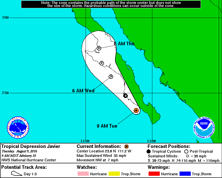
NHC降格熱帶低壓,將沿著半島西岸北上
000
WTPZ41 KNHC 091434
TCDEP1

TROPICAL DEPRESSION JAVIER DISCUSSION NUMBER  10
NWS NATIONAL HURRICANE CENTER MIAMI FL       EP112016
900 AM MDT TUE AUG 09 2016

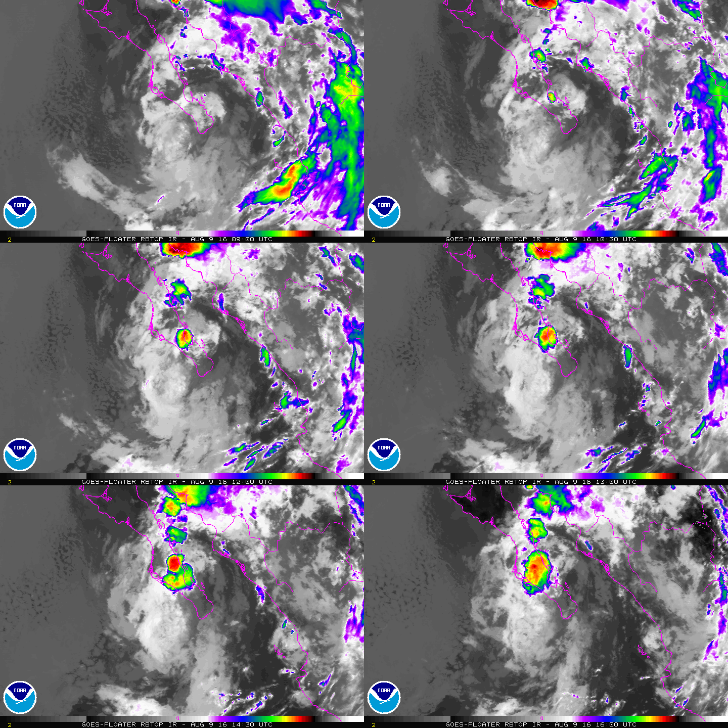
The only areas of deep convection associated with Javier are some
small patches of showers and thunderstorms over the southern Baja
California peninsula.  The cyclone is embedded within an air mass
that is forecast to become drier and more stable with time.
Therefore the system is likely to degenerate into a remnant low
within 24 hours, or sooner. The low is expected to dissipate over
the central Baja California peninsula later in the forecast period.

The center has become less defined but is believed to be located
just offshore between Cabo San Lucas and Cabo San Lazaro, and the
initial motion estimate is an uncertain 310/6.  Over the next
couple of days, Javier or its remnant low should continue to move
around the western periphery of a mid-level high pressure system.
The official track forecast continues to follow the multi-model
consensus, TVCN.

FORECAST POSITIONS AND MAX WINDS

INIT  09/1500Z 23.8N 111.2W   30 KT  35 MPH
12H  10/0000Z 24.8N 112.0W   30 KT  35 MPH
24H  10/1200Z 26.1N 113.1W   25 KT  30 MPH...POST-TROP/REMNT LOW
36H  11/0000Z 27.0N 113.8W   25 KT  30 MPH...POST-TROP/INLAND
48H  11/1200Z 28.0N 114.0W   20 KT  25 MPH...POST-TROP/INLAND
72H  12/1200Z...DISSIPATED

$$
Forecaster Pasch

143709W_NL_sm.gif

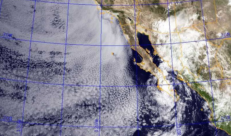
捲入大量乾空氣,中心全裸了。
20160809.1600.goes_15.visir.bckgr.NorthAmerica-CONUS-West_x-x-x.DAY.jpg

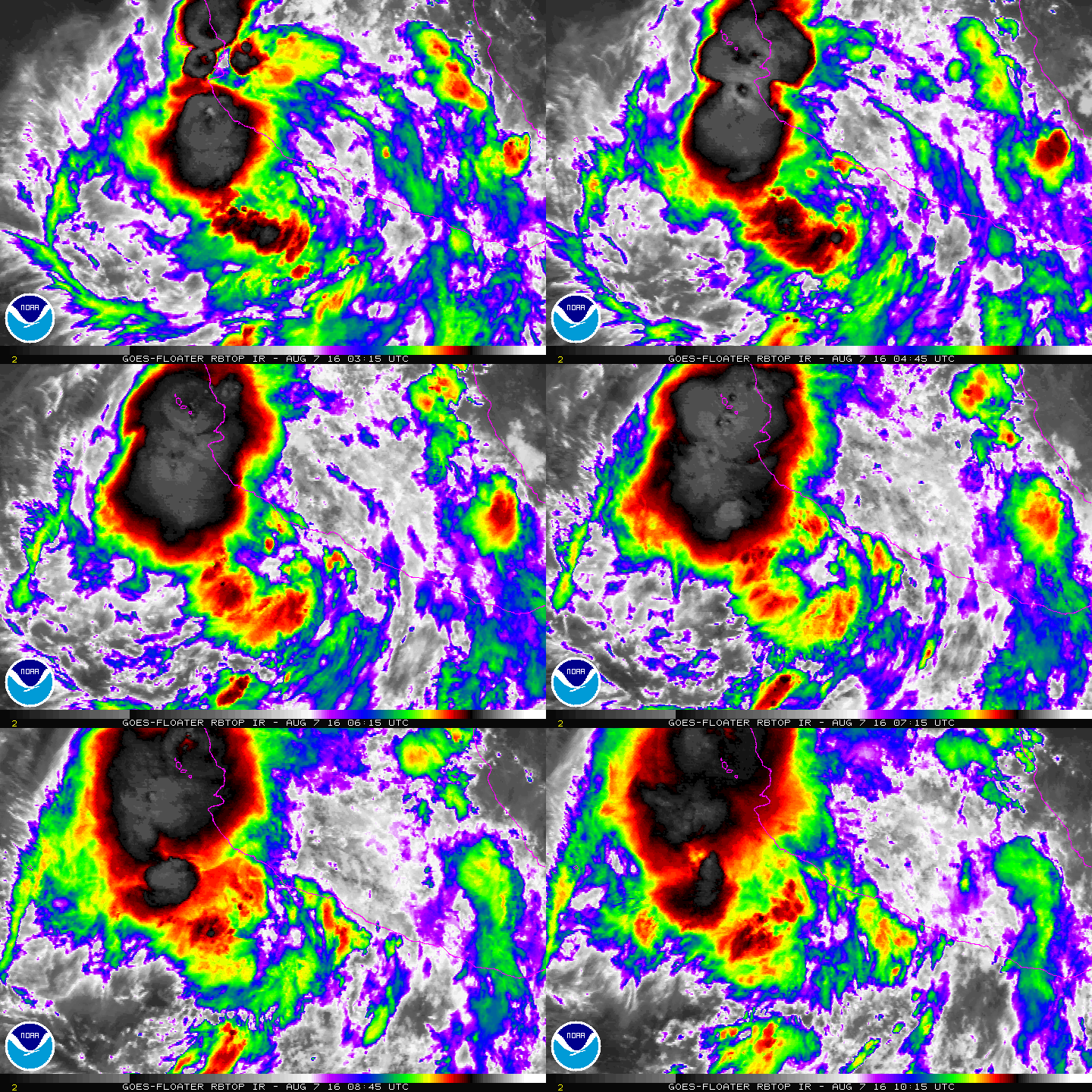
rbtop-animated.gif
Meow 發表於 2016-8-8 00:28
NHC發佈特報,升格命名Javier。

000
WTPZ61 KNHC 071604
TCUEP1

TROPICAL STORM JAVIER TROPICAL CYCLONE UPDATE
NWS NATIONAL HURRICANE CENTER MIAMI FL       EP112016
1100 AM CDT SUN AUG 07 2016

...DEPRESSION STRENGTHENS INTO A TROPICAL STORM...

Surface observations from Manzanillo, Mexico, indicate that the
depression has strengthened into Tropical Storm Javier. The maximum
winds are estimated to be 45 mph (75 km/h) with higher gusts.

SUMMARY OF 1100 AM CDT...1600 UTC...INFORMATION
----------------------------------------------
LOCATION...18.9N 105.4W
ABOUT 55 MI...90 KM WSW OF MANZANILLO MEXICO
MAXIMUM SUSTAINED WINDS...45 MPH...75 KM/H
PRESENT MOVEMENT...WNW OR 300 DEGREES AT 10 MPH...16 KM/H
MINIMUM CENTRAL PRESSURE...1000 MB...29.53 INCHES

$$
Forecaster Kimberlain/Pasch
t02436 發表於 2016-8-7 19:03
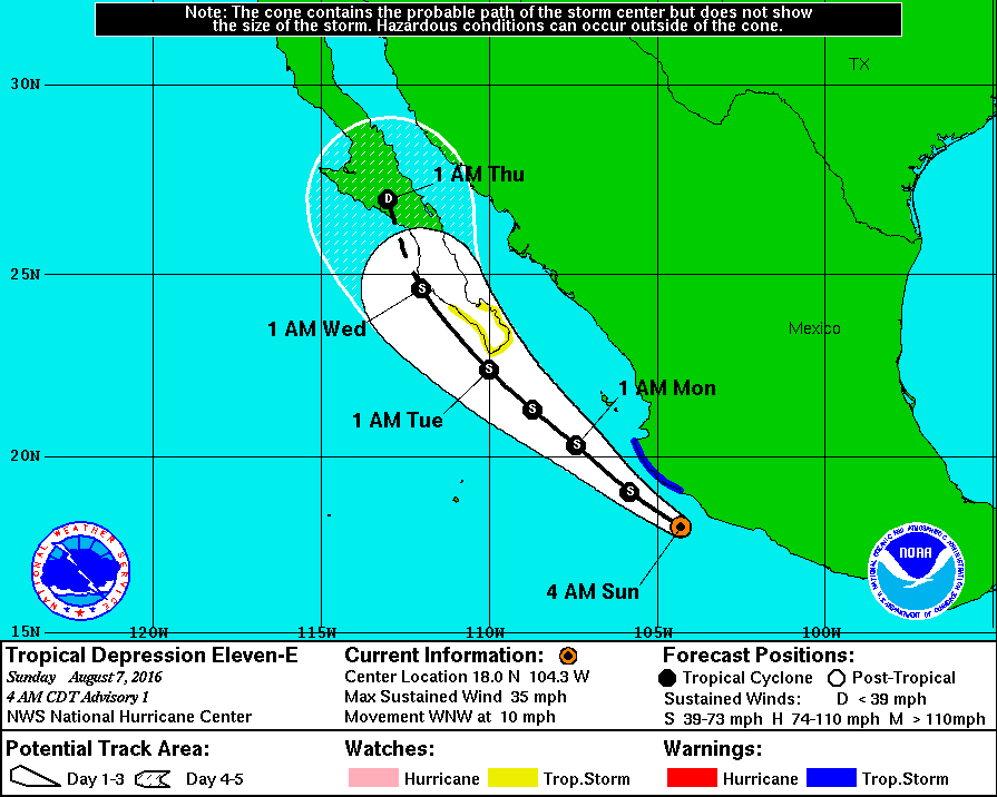
NHC升格11E,預測將以TS下限左右的強度襲擊下加利福尼亞半島
000
WTPZ41 KNHC 070854
TCDEP1

TROPICAL DEPRESSION ELEVEN-E DISCUSSION NUMBER   1
NWS NATIONAL HURRICANE CENTER MIAMI FL       EP112016
400 AM CDT SUN AUG 07 2016

The low pressure area near the southwestern coast of Mexico has
become better defined overnight, and there is sufficient convective
organization to classify the system as a tropical depression.
Although the convection near the center has recently decreased,
there are several curved bands around the outer portion of the
circulation.  Recent land-based observations indicate that brisk
southeasterly winds are occurring along the immediate coast of
Mexico, and ship H9LA reported a minimum pressure of 1004.9 mb and
31 kt southerly winds early in the evening.  Based on these data,
the initial wind speed is estimated to be 30 kt.

The forecast track of the depression takes it over very warm water
during the next couple of days, but moderate easterly shear and
interaction with the mountainous terrain of southwestern Mexico
should mean only slight strengthening today.  Additional modest
intensification is expected tonight and Monday, before the system
nears the southern portion of the Baja California peninsula in
about 48 hours.  After that time, interaction with land and a more
stable airmass should cause weakening, and the cyclone is forecast
to dissipate near or over the central Baja California peninsula in
4 to 5 days.  The NHC intensity forecast is in good agreement
with the SHIPS guidance, which is a little above the dynamical
models.

Since the tropical cyclone is still in its formative stage, the
initial motion estimate is a highly uncertain 290/9 kt.  The
depression is forecast to turn northwesterly by late Sunday as it
moves around the southwestern portion of a strong mid-level ridge
centered over the south-central United States.  In 3 to 4 days, a
deepening mid-level trough off the west coast of the United States
should cause the cyclone to turn north-northwestward or northward.
The track guidance is in good agreement and the NHC forecast lies
near the multi-model consensus.


FORECAST POSITIONS AND MAX WINDS

INIT  07/0900Z 18.0N 104.3W   30 KT  35 MPH
12H  07/1800Z 19.0N 105.8W   35 KT  40 MPH
24H  08/0600Z 20.3N 107.4W   40 KT  45 MPH
36H  08/1800Z 21.3N 108.7W   45 KT  50 MPH
48H  09/0600Z 22.4N 110.0W   50 KT  60 MPH
72H  10/0600Z 24.6N 112.0W   35 KT  40 MPH
96H  11/0600Z 27.0N 113.0W   25 KT  30 MPH...INLAND
120H  12/0600Z...DISSIPATED

$$
Forecaster Brown

085609W_sm.gif

rbtop-animated.gif

本平台僅供學術討論之用,預報應以氣象局為準

威普網站虛擬主機贊助公司

臺灣第一個天氣類型社群平台 即時天氣資訊、精準颱風動態

線上客服
FB傳送訊息
廣告行銷
精準行銷 物超所值
官方粉專
發佈 快速回復 返回頂部 返回列表