開啟輔助訪問
 找回密碼
 立即加入

17S.Frances 橫越北澳外海

查看數: 10782 評論數: 9 收藏 0切换到帖子模式
    組圖打開中,請稍候......
發佈時間: 2017-4-21 18:57

正文摘要:

本帖最後由 s6815711 於 2017-5-2 17:53 編輯   三級強烈熱帶氣旋   編號:29 U ( 17 S ) 名稱:Frances   基本資料   擾動編號日期:2017 年 04 月 21 日 18 時 命名 ...

W環 發表於 2017-5-1 10:40
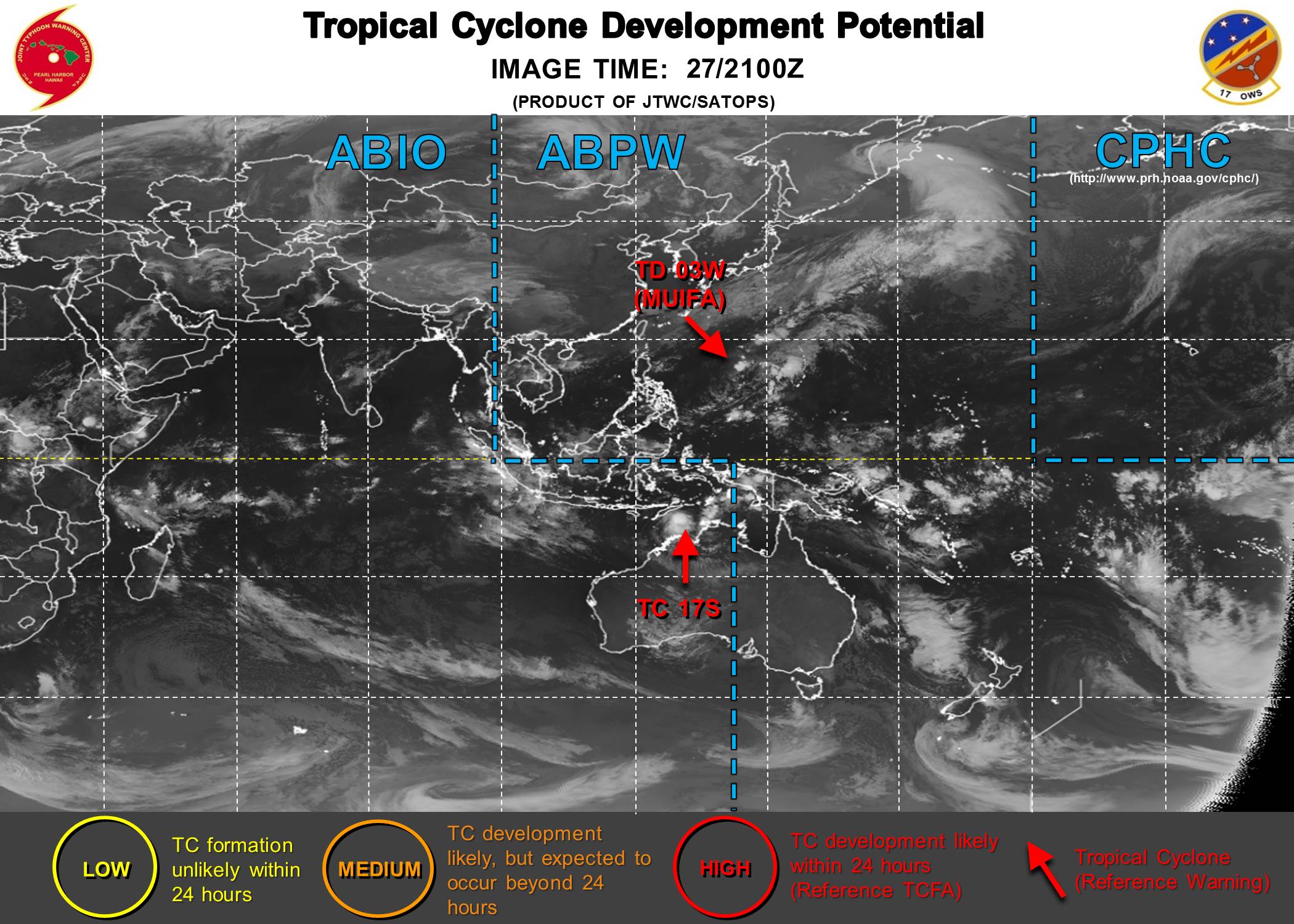
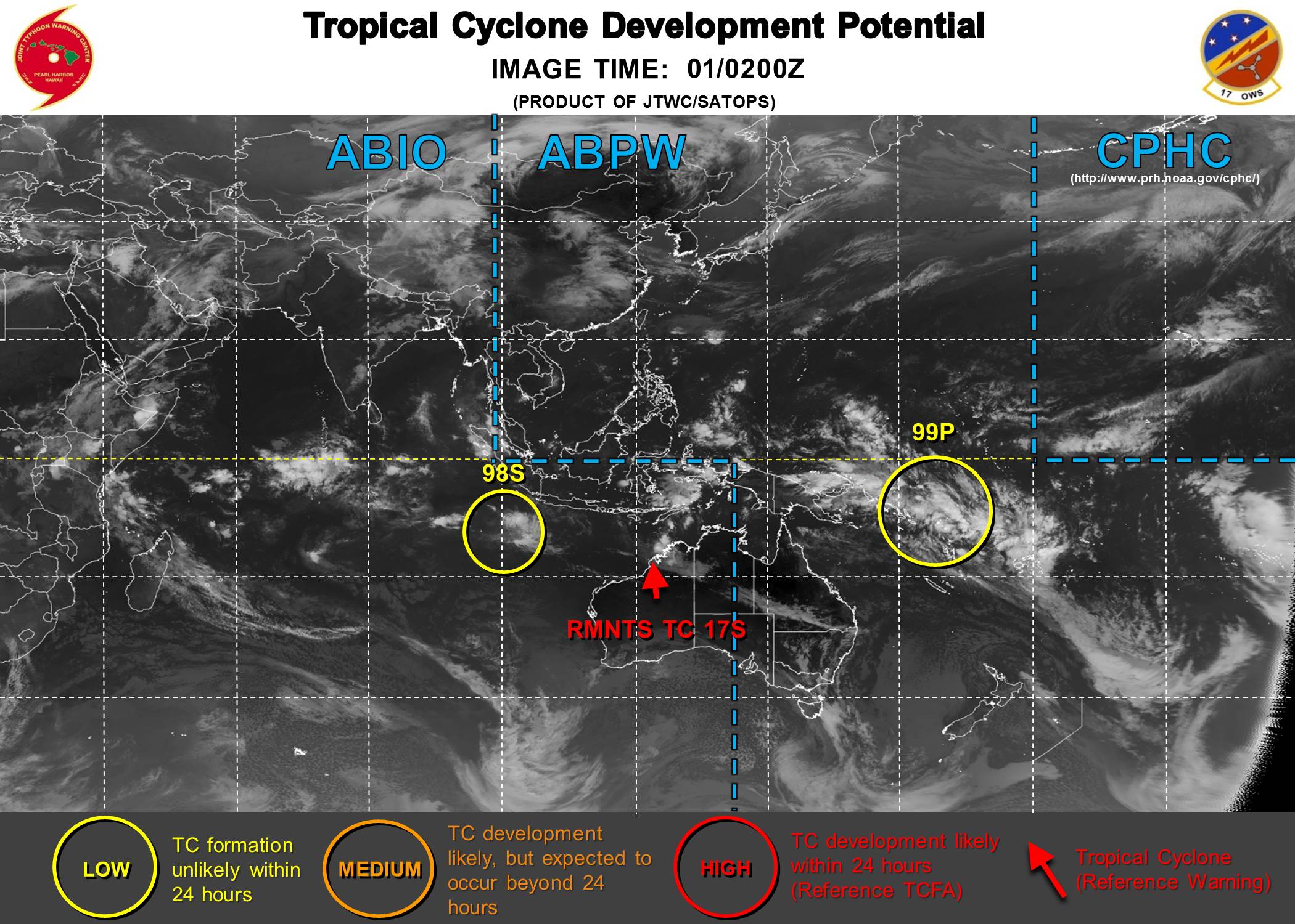
已經消散 abpwsair.jpg


krichard2011 發表於 2017-4-28 20:16
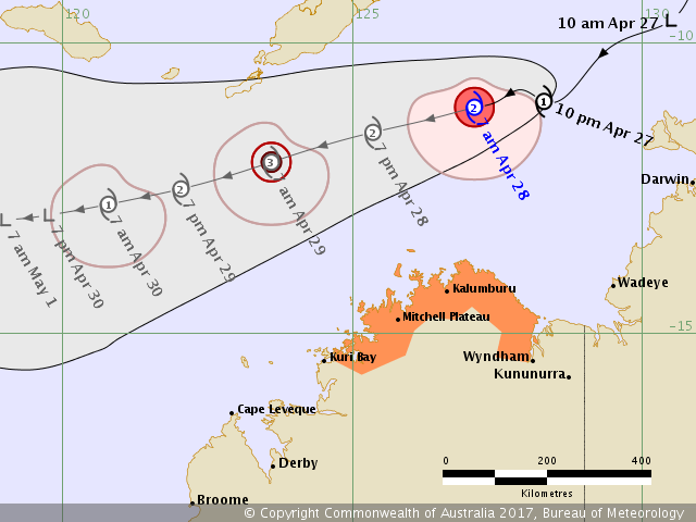
BoM 已升格三級強烈熱帶氣旋
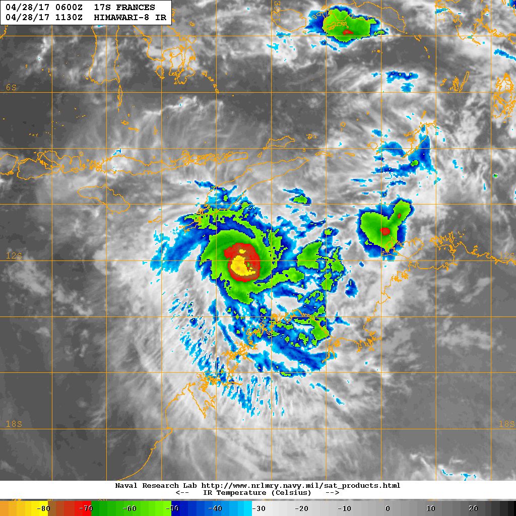
現在看起來差不多要開眼了
也是一個小鋼炮型的熱帶氣旋
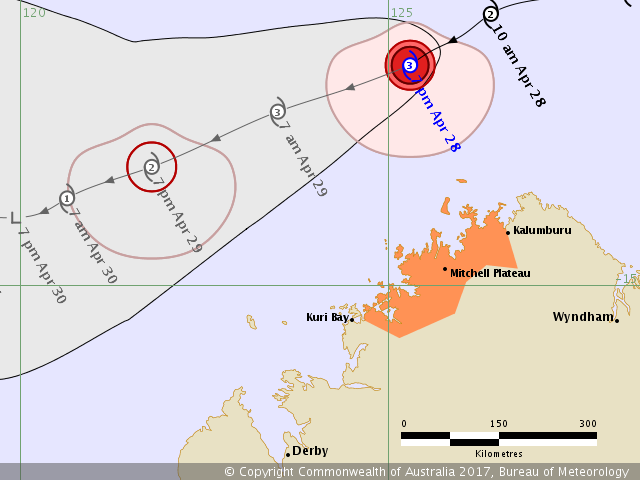
IDD65001.png
20170428.1130.himawari8.x.ir1km.17SFRANCES.60kts-978mb-119S-1255E.100pc.jpg
  1. IDD20020
  2. TROPICAL CYCLONE TECHNICAL BULLETIN: AUSTRALIA - NORTHERN REGION
  3. Issued by DARWIN TROPICAL CYCLONE WARNING CENTRE
  4. at: 0716 UTC 28/04/2017
  5. Name: Severe Tropical Cyclone Frances
  6. Identifier: 29U
  7. Data At: 0600 UTC
  8. Latitude: 11.8S
  9. Longitude: 125.6E
  10. Location Accuracy: within 15 nm [30 km]
  11. Movement Towards: west southwest [237 deg]
  12. Speed of Movement: 9 knots [17 km/h]
  13. Maximum 10-Minute Wind: 65 knots [120 km/h]
  14. Maximum 3-Second Wind Gust: 90 knots [165 km/h]
  15. Central Pressure: 983 hPa
  16. Radius of 34-knot winds NE quadrant: 35 nm [65 km]
  17. Radius of 34-knot winds SE quadrant: 75 nm [140 km]
  18. Radius of 34-knot winds SW quadrant: 75 nm [140 km]
  19. Radius of 34-knot winds NW quadrant: 35 nm [65 km]
  20. Radius of 48-knot winds NE quadrant: 20 nm [35 km]
  21. Radius of 48-knot winds SE quadrant: 20 nm [35 km]
  22. Radius of 48-knot winds SW quadrant: 20 nm [35 km]
  23. Radius of 48-knot winds NW quadrant: 20 nm [35 km]
  24. Radius of 64-knot winds: 15 nm [30 km]
  25. Radius of Maximum Winds: 15 nm [30 km]
  26. Dvorak Intensity Code: T4.5/4.5/D1.5/24HRS
  27. Pressure of outermost isobar: 1010 hPa
  28. Radius of outermost closed isobar: 120 nm [220 km]
  29. FORECAST DATA
  30. Date/Time    : Location    : Loc. Accuracy: Max Wind   : Central Pressure
  31. [UTC]        : degrees     :      nm  [km]: knots[km/h]: hPa
  32. +06:  28/1200: 12.1S 124.5E:     040 [080]:  070  [130]:  984
  33. +12:  28/1800: 12.4S 123.5E:     055 [100]:  075  [140]:  983
  34. +18:  29/0000: 12.8S 122.5E:     065 [125]:  070  [130]:  984
  35. +24:  29/0600: 13.0S 121.6E:     080 [145]:  060  [110]:  986
  36. +36:  29/1800: 13.3S 120.3E:     100 [185]:  050  [095]:  994
  37. +48:  30/0600: 13.5S 119.2E:     120 [220]:  030  [055]: 1003
  38. +60:  30/1800: 13.6S 118.4E:     140 [255]:  030  [050]: 1006
  39. +72:  01/0600: 13.6S 117.8E:     155 [290]:  025  [045]: 1004
  40. +96:  02/0600: 13.4S 116.5E:     200 [370]:  025  [045]: 1005
  41. +120: 03/0600: 12.4S 114.4E:     270 [500]:  015  [030]: 1012
  42. REMARKS:
  43. Severe Tropical Cyclone Frances has shown evidence of an eye developing over the
  44. last three hours. This, combined with earlier microwave and scatterometer
  45. passes, gives high confidence in the location of the system.

  46. Intensity was based on PAT and MET [with a D+] as DT not clear, despite
  47. appearance of an eye, due to cirrus over the eye. The FT is also biased towards
  48. the FT and CI = 4.5 by the overnight Ascat pass at 1336 UTC indicating winds of
  49. 45-50 knots on the southern side and observations in the area of 40-50 knots.

  50. The cyclone is located in a moist environment in a diffluent upper-level outflow
  51. pattern just north of the upper level ridge. This is creating strong upper-level
  52. divergence with twin outflow channels seen in recent satellite imagery. This, in
  53. conjunction with the arrival of a strong east to southeasterly surge from a
  54. developing ridge over Australia, has sustained continued development of the
  55. cyclone.

  56. Model consensus suggest the cyclone will move towards the west-southwest over
  57. the next few days due to mid level ridges located to the south and east. On this
  58. west-southwesterly track, the system is expected to remain in a low sheared
  59. environment and in a diffluent upper pattern for about another 24 hours before
  60. the shear increases.

  61. From later Saturday, the cyclone is expected to move into this higher shear
  62. environment due to a mid to upper level trough approaching from the west, with
  63. dry air entrainment weakening the system to below Tropical Cyclone strength on
  64. Sunday.

  65. Copyright Commonwealth of Australia
  66. ==
  67. The next bulletin for this system will be issued by: 28/1400 UTC by Darwin TCWC.
複製代碼

點評

強度坐溜滑梯準備消散了,不看好再發展  發表於 2017-5-1 10:33
W環 發表於 2017-4-28 08:44
BOM上看澳式C3
IDD65001.png


abpwsair.jpg

劉瑞益@FB 發表於 2017-4-28 02:26
提示: 作者被禁止或刪除 內容自動屏蔽
W環 發表於 2017-4-27 17:38
BOM命名為Frances

Intensity: category 1, sustained winds near the centre of 65 kilometres per hour with wind gusts to 95 kilometres per hour.
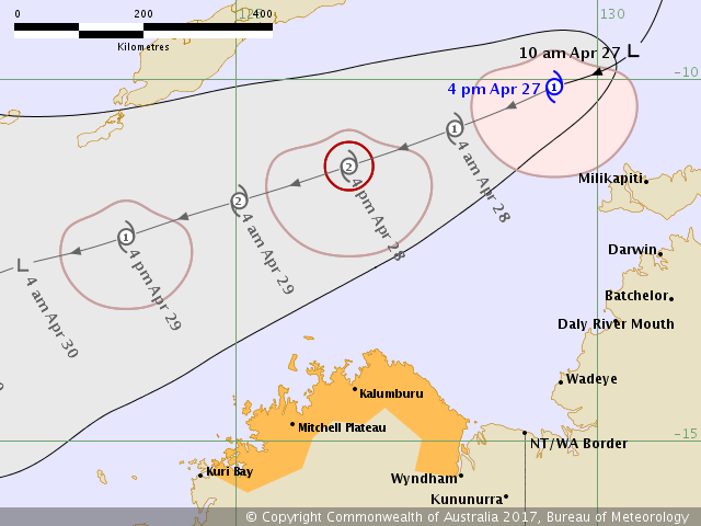
Location: within 55 kilometres of 10.1 degrees South, 129.4 degrees East , 185 kilometres northwest of Pirlangimpi and 555 kilometres north northeast of Kalumburu .
Movement: west southwest at 16 kilometres per hour .

Tropical Cyclone Frances is expected to intensify as it moves southwest through the Timor Sea. It is not expected to cause gales in coastal areas on Friday however if it takes a more southerly track gales may commence on the north Kimberley coast on Saturday

image.png

點評

BOM編號"29U"  發表於 2017-4-27 19:02
劉瑞益@FB 發表於 2017-4-27 12:41
提示: 作者被禁止或刪除 內容自動屏蔽
W環 發表於 2017-4-26 11:14
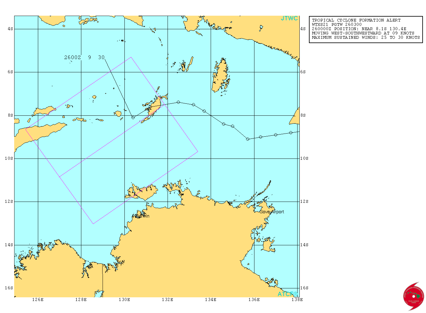
TCFA

THE AREA OF CONVECTION (INVEST 97P) PREVIOUSLY LOCATED
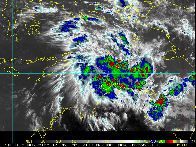
NEAR 7.4S 132.5E, IS NOW LOCATED NEAR 8.1S 130.4E, APPROXIMATELY 265
NM NORTH OF DARWIN, AUSTRALIA. ANIMATED MULTISPECTRAL SATELLITE
IMAGERY DEPICTS A QUICKLY CONSOLIDATING LOW LEVEL CIRCULATION WITH
CONSTANT CONVECTION WRAPPING INTO THE CENTER AND A MOSTLY CIRCULAR
SHAPE. A 252209Z SSMIS 91GHZ PARTIAL MICROWAVE PASS AND A 251946Z
GMI 89GHZ MICROWAVE PASS SHOW DEEP CONVECTION WRAPPING INTO THE
CENTER OF THE LOW LEVEL CIRCULATION THAT HAS RAPIDLY BECOME LESS AND
LESS ELONGATED THROUGHOUT THE DAY. THE DISTURBANCE IS CURRENTLY
LOCATED IN A MARGINAL BUT IMPROVING ENVIRONMENT WITH MODERATE
VERTICAL WIND SHEAR (20 KNOTS), THAT IS BEING OFFSET BY STRONG
POLEWARD UPPER LEVEL OUTFLOW AND VERY WARM SEA SURFACE TEMPERATURES
(30-31 CELSIUS). GLOBAL MODELS ARE IN AGREEMENT THAT THE DISTURBANCE
WILL CONTINUE TO TRACK TO THE SOUTHWEST OVER THE NEXT SEVERAL DAYS
AND ARE SHOWING INTENSIFICATION AND CONSOLIDATION WITHIN THE NEXT 24-
48 HOURS. MAXIMUM SUSTAINED SURFACE WINDS ARE ESTIMATED AT 25 TO 30
KNOTS. MINIMUM SEA LEVEL PRESSURE IS ESTIMATED TO BE NEAR 1000 MB.
THE POTENTIAL FOR THE DEVELOPMENT OF A SIGNIFICANT TROPICAL CYCLONE
WITHIN THE NEXT 24 HOURS IS HIGH.

2017SH97_4KMIRIMG_201704260220.GIF

sh972017.20170426021858.gif

本平台僅供學術討論之用,預報應以氣象局為準

威普網站虛擬主機贊助公司

臺灣第一個天氣類型社群平台 即時天氣資訊、精準颱風動態

線上客服
FB傳送訊息
廣告行銷
精準行銷 物超所值
官方粉專
發佈 快速回復 返回頂部 返回列表