開啟輔助訪問
 找回密碼
 立即加入

15L.Odette 轉化溫氣

查看數: 7819 評論數: 7 收藏 0切换到帖子模式
    組圖打開中,請稍候......
發佈時間: 2021-9-14 21:05

正文摘要:

  熱帶風暴   編號:15 L 名稱:Odette 以上資料來自:NHC、颱風論壇整理製作

周子堯@FB 發表於 2021-9-18 08:42
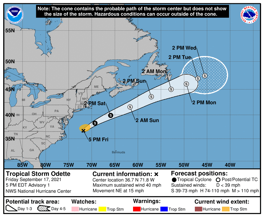
首報強度上望45kts,後轉性溫氣
000
WTNT45 KNHC 172037
TCDAT5

Tropical Storm Odette Discussion Number   1
NWS National Hurricane Center Miami FL       AL152021
500 PM EDT Fri Sep 17 2021

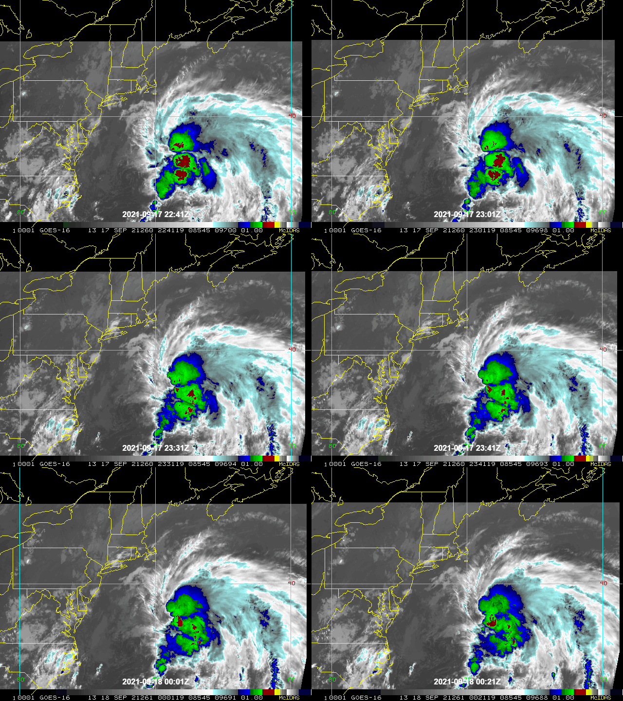
The circulation associated with the area of low pressure off the
U.S. Mid-Atlantic coast has become better defined today, with a
new center having developed near a persistent cluster of deep
convection.  This system has some non-tropical characteristics, with
a developing frontal boundary draped around the northern and western
side of the circulation.  Although the convection is being sheared
off to the northeast of the center, the structure still resembles
that of a tropical cyclone.  An ASCAT-C pass from a few hours ago
showed that maximum winds were 30-35 kt to the north of the center,
thus advisories are being initiated on Tropical Storm Odette with
35-kt winds.

With the re-formation of the center, the initial motion is
uncertain but is estimated to be northeastward, or 045/13 kt.
Odette is embedded between the subtropical ridge over the western
Atlantic and a deep-layer trough over the U.S. Upper Midwest and
central Canada.  The approach of this trough should cause Odette to
accelerate toward the northeast and then east-northeast during the
next few days.  After about day 3, there is significant divergence
among the models.  The GFS ejects the system northeastward and
stalls it over the north Atlantic, south of Greenland.  The ECMWF,
UKMET, and Canadian models, however, stall the cyclone sooner and
have it meandering south of Newfoundland on days 4 and 5.  For now,
the NHC track forecast shows Odette slowing down significantly on
those days (less than 5 kt on day 5) and is a blend of the TVCA and
HCCA consensus aids.

Odette's transition to an extratropical cyclone is probably already
underway.  The storm is also centered over the Gulf Stream, where
water temperatures are about 28 degrees Celsius, so in the short
term it is likely that a combination of baroclinic and convective
forcing will cause some intensification, despite deep-layer shear
strengthening to near 30 kt.  The global models suggest that Odette
should become fully extratropical by 36 hours, and the intensity
models indicate that the post-tropical low should peak in
intensity in 48-60 hours.  The low is then likely to occlude by day
3, a process which typically leads to gradual weakening, which is
indicated in the official forecast.

Odette is expected to affect portions of Newfoundland with strong
winds and heavy rainfall Sunday and Sunday night as a
post-tropical cyclone.  Please refer to products from Environment
Canada for additional information on potential impacts in
Newfoundland.


FORECAST POSITIONS AND MAX WINDS

INIT  17/2100Z 36.7N  71.8W   35 KT  40 MPH
12H  18/0600Z 38.3N  69.3W   40 KT  45 MPH
24H  18/1800Z 39.9N  65.9W   45 KT  50 MPH
36H  19/0600Z 41.6N  61.7W   50 KT  60 MPH...POST-TROP/EXTRATROP
48H  19/1800Z 43.6N  57.1W   55 KT  65 MPH...POST-TROP/EXTRATROP
60H  20/0600Z 45.0N  52.8W   55 KT  65 MPH...POST-TROP/EXTRATROP
72H  20/1800Z 46.0N  49.5W   50 KT  60 MPH...POST-TROP/EXTRATROP
96H  21/1800Z 47.0N  47.0W   45 KT  50 MPH...POST-TROP/EXTRATROP
120H  22/1800Z 47.5N  45.5W   35 KT  40 MPH...POST-TROP/EXTRATROP

$$
Forecaster Berg

051231piol22w7pwp35xzl.png
下載.gif
king111807 發表於 2021-9-16 10:46
NHC展望提升至High,70%
2. A low pressure system located about midway between the Bahamas and
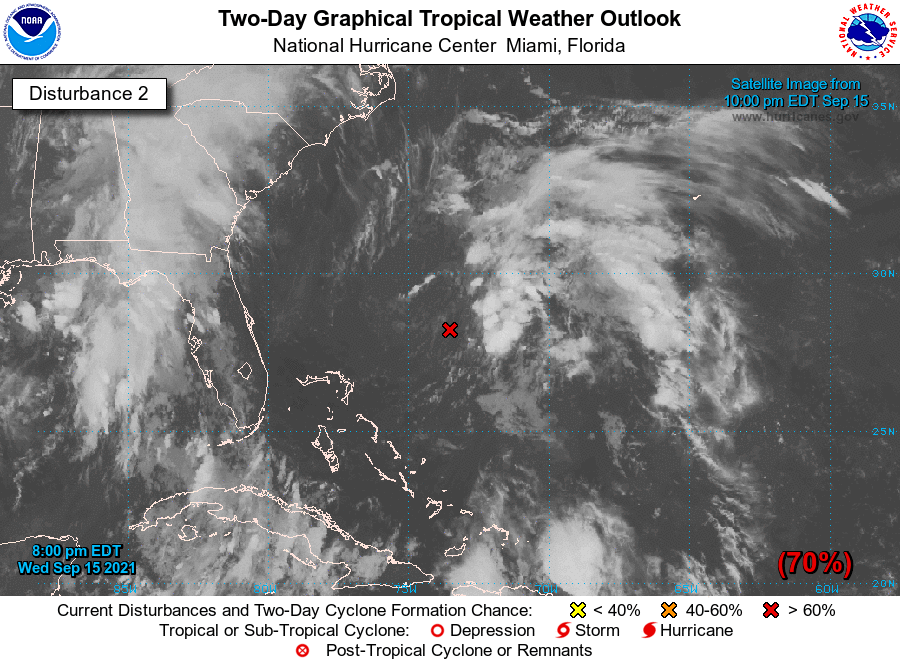
Bermuda is producing poorly organized shower activity.  An Air
Force Reserve Hurricane Hunter aircraft investigating the system
this afternoon reported that the circulation was disorganized and
that the strongest winds were well to the east of the center.  
Environmental conditions are expected to become more conducive for
development, and a tropical depression is likely to form during the
next day or two while the system moves north-northwestward to
northward off the southeast U.S. coast.  Regardless of development,
this system could bring high surf to portions of the southeast and
mid-Atlantic U.S. coasts later this week.
* Formation chance through 48 hours...high...70 percent.
* Formation chance through 5 days...high...70 percent.
two_atl_2d2.png
king111807 發表於 2021-9-16 01:44
FWC-N發布TCFA
SUBJ/TROPICAL CYCLONE FORMATION ALERT (96L)//
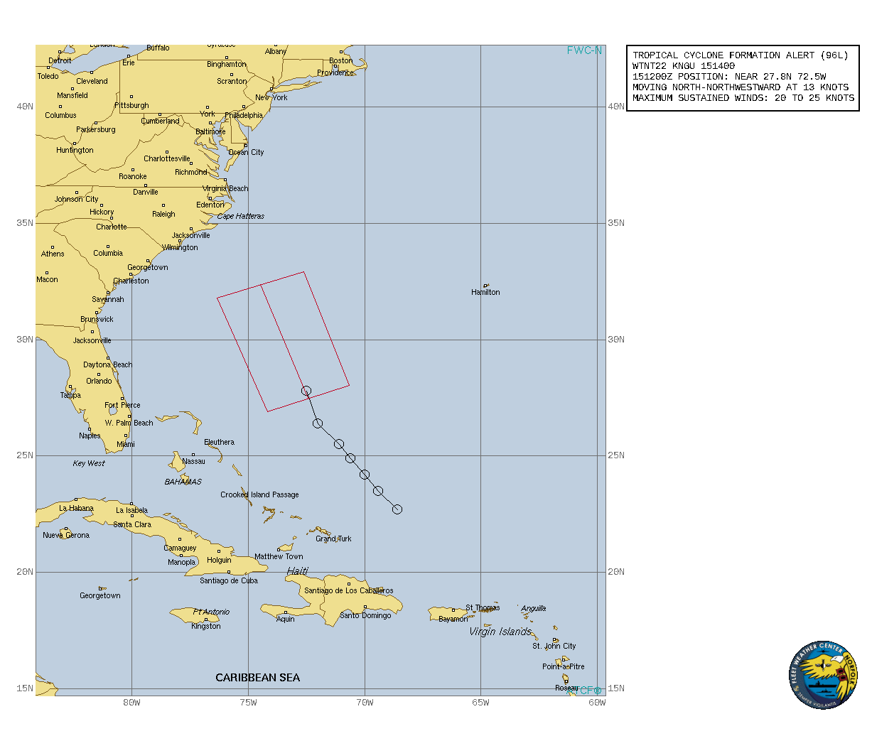
WTNT22 KNGU 151400
REF/A/FLEWEACEN NORFOLK VA/142200Z SEP 21//
AMPN/REF IS TROPICAL CYCLONE FORMATION ALERT (WTNT21 KNGU 142200)//
RMKS/1. FORMATION OF A TROPICAL CYCLONE IS POSSIBLE WITHIN
100 NM EITHER SIDE OF A LINE FROM 27.8N 72.5W TO 32.4N 74.5W
WITHIN THE NEXT 24 HOURS. AVAILABLE DATA DOES NOT JUSTIFY
ISSUANCE OF NUMBERED TROPICAL CYCLONE WARNINGS AT THIS TIME.
WINDS IN THE AREA ARE ESTIMATED TO BE 20 TO 25 KNOTS. METSAT
IMAGERY AT 151200Z INDICATES THAT A CIRCULATION CENTER IS LOCATED
NEAR 27.8N 72.5W. THE SYSTEM IS MOVING NORTH-NORTHWESTWARD AT 13
KNOTS.
2. A BROAD AREA OF LOW PRESSURE LOCATED A FEW HUNDRED MILES
NORTHEAST OF THE CENTRAL BAHAMAS IS PRODUCING A LARGE AREA OF
DISORGANIZED SHOWERS AND THUNDERSTORMS. ENVIRONMENTAL CONDITIONS
APPEAR MARGINALLY CONDUCIVE FOR DEVELOPMENT, AND A TROPICAL
DEPRESSION IS LIKELY TO FORM DURING THE NEXT DAY OR SO WHILE THE
SYSTEM MOVES NORTH-NORTHWESTWARD TO NORTHWARD OFF THE SOUTHEAST U.S.
COAST.
3. THIS ALERT WILL BE REISSUED, UPGRADED TO WARNING OR CANCELLED BY
161400Z.
4. SEE REF A FOR DETAILS ON A TROPICAL CYCLONE FORMATION ALERT (95L)
LOCATED NEAR 10.2N 26.1W.//
BT
al962021 (1).gif
king111807 發表於 2021-9-15 15:18
NHC展望升至60%
2. A trough of low pressure located a few hundred miles northeast of
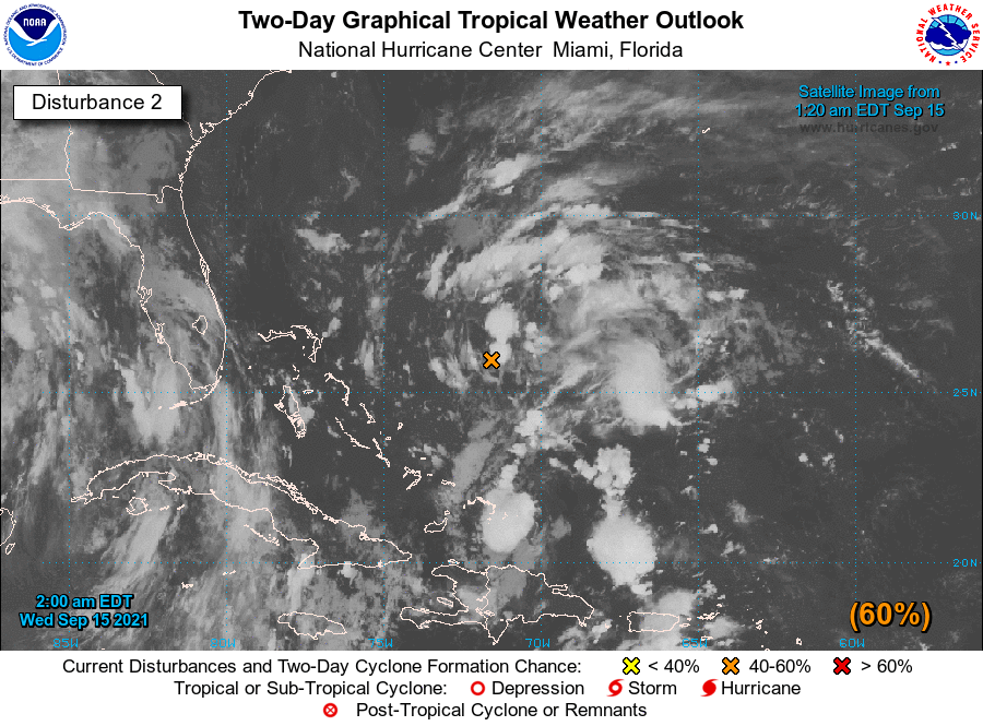
the central Bahamas is producing a large area of disorganized
showers and thunderstorms.  Environmental conditions appear
marginally conducive for gradual development during the next few
days, and a tropical depression is likely to form while the system
moves north-northwestward to northward across the western Atlantic.
* Formation chance through 48 hours...medium...60 percent.
* Formation chance through 5 days...high...70 percent.
two_atl_2d2.png
king111807 發表於 2021-9-15 10:04
NHC展望升至50%
2. A trough of low pressure located a couple of hundred miles
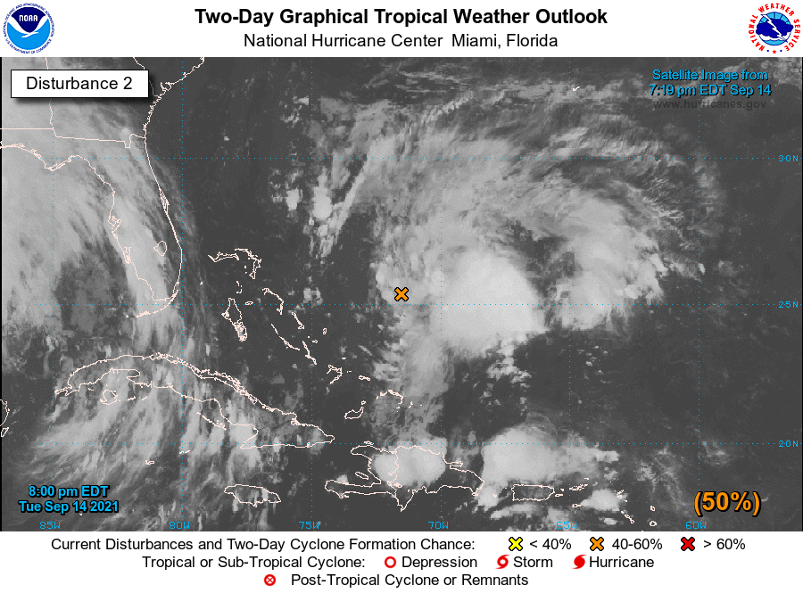
north-northeast of the southeastern Bahamas is producing a large
area of disorganized showers and thunderstorms.  Environmental
conditions are forecast to be marginally conducive for gradual
development during the next few days, and a tropical depression is
likely to form while the system moves north-northwestward to
northward across the western Atlantic.
* Formation chance through 48 hours...medium...50 percent.
* Formation chance through 5 days...high...70 percent.
two_atl_2d2.png
king111807 發表於 2021-9-15 01:58
NHC展望升至Medium,40%
2. A trough of low pressure located a couple of hundred miles
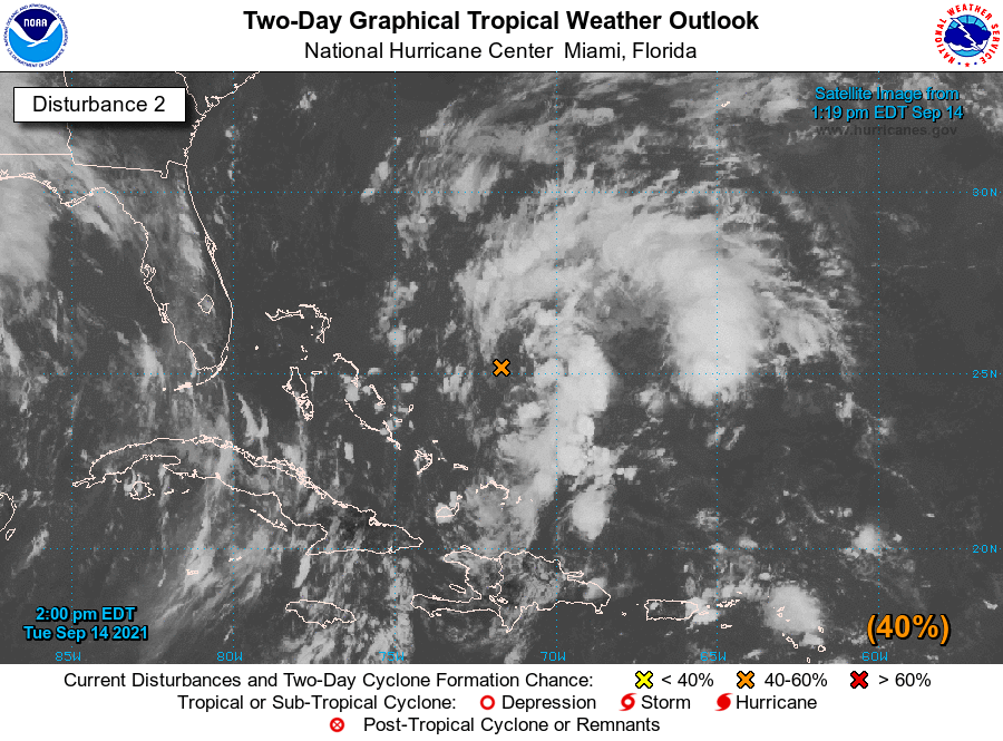
northeast of the southeastern Bahamas is producing a large area
of disorganized showers and thunderstorms.  Environmental
conditions are forecast to be conducive for gradual development
during the next few days, and a tropical depression could form
while the system moves north-northwestward to northward across the
western Atlantic.
* Formation chance through 48 hours...medium...40 percent.
* Formation chance through 5 days...medium...60 percent.
two_atl_2d2.png

本平台僅供學術討論之用,預報應以氣象局為準

威普網站虛擬主機贊助公司

臺灣第一個天氣類型社群平台 即時天氣資訊、精準颱風動態

線上客服
FB傳送訊息
廣告行銷
精準行銷 物超所值
官方粉專
發佈 快速回復 返回頂部 返回列表