開啟輔助訪問
 找回密碼
 立即加入

14L.Michael 近岸爆發升C5 巔峰登陸 本世紀登陸美國最強颶風

簽到天數: 601 天

[LV.9]以壇為家II

2018-10-6 02:46 | 顯示全部樓層
本帖最後由 霧峰追風者 於 2020-8-27 08:55 編輯

  五級颶風  
編號:14 L
名稱:Michael

  基本資料  
擾動編號日期:2018 10 06 01
命名日期  :2018 10 08 05
撤編日期  :2018 10 00 00
登陸地點  :暫無

  巔峰時期資料  
近中心最強風速 :140 kt
海平面最低氣壓 :919 百帕

  過去路徑圖  

  擾動編號資料  

91L.INVEST.15kts-1012mb-20.0N-83.0W

20181005.0846.f15.37h.91L.INVEST.15kts.1012mb.20N.83W.085pc.jpg
NHC : 40%
1. A broad area of low pressure centered near the northeastern coast
of Honduras is drifting northwestward and producing disorganized
shower and thunderstorm activity from Central America
east-northeastward across the Western Caribbean to Hispaniola.
Although strong winds aloft persist just to the north of the
system, the upper-level environment is expected to be conducive
enough to allow slow development.  A tropical depression could
form by late this weekend or early next week over the northwestern
Caribbean Sea or Gulf of Mexico while the system moves northwestward
to northward.  Regardless of tropical cyclone formation, this
disturbance will continue to bring torrential rains primarily to
portions of Central America and the Yucatan peninsula during the
next few days.
* Formation chance through 48 hours...medium...40 percent.
* Formation chance through 5 days...high...70 percent.

two_atl_2d1.png


以上資料來自:NHC、颱風論壇整理製作

評分

參與人數 1水氣能量 +15 +1 收起 理由
king111807 + 15 + 1 熱帶擾動首帖

查看全部評分

回復

使用道具 舉報

簽到天數: 601 天

[LV.9]以壇為家II

霧峰追風者|2018-10-7 00:33 | 顯示全部樓層
NHC 展望提升至90%。
1. Satellite imagery, surface observations, and radar data from Belize
indicate that an area of low pressure is centered just north of the
Bay Islands of Honduras.  The associated showers and thunderstorms
show signs of organization, however, the system does not yet have a
well-defined circulation.  Environmental conditions are expected to
become gradually more conducive for further development, and a
tropical depression or tropical storm is expected to form over the
northwestern Caribbean Sea or the southern Gulf of Mexico on Sunday
or Monday while the system moves slowly northward. Interests in the
Yucatan peninsula, western Cuba, and the northern coast of the Gulf
of Mexico should monitor the progress of this system during the next
several days.  Regardless of tropical cyclone formation, this
disturbance will continue to bring torrential rains to portions of
Central America, the Yucatan peninsula, and western Cuba into next
week.
* Formation chance through 48 hours...high...80 percent.
* Formation chance through 5 days...high...90 percent.
two_atl_2d1 (2).png al912018.18100606.gif 20181006.1500.goes15.x.vis1km_high.91LINVEST.25kts-1007mb-173N-862W.100pc.jpg 91L_gefs_latest.png

回復

使用道具 舉報

簽到天數: 601 天

[LV.9]以壇為家II

霧峰追風者|2018-10-7 13:02 | 顯示全部樓層
升格潛在熱帶氣旋14L,進入墨灣後將影響美國。
000
WTNT44 KNHC 070235
TCDAT4

Potential Tropical Cyclone Fourteen Discussion Number   2
NWS National Hurricane Center Miami FL       AL142018
1000 PM CDT Sat Oct 06 2018

The cloud pattern has improved in organization and surface pressures
are gradually falling, but there is no evidence that the system is
a tropical cyclone at this time.  All indications are, however, that
a tropical depression will likely form at any time soon. Strong wind
shear is expected to affect the disturbance, and the SHIPS model
only show a modest strengthening. This is in contrast to some global
models and the HWRF, which are more aggressive in developing this
system.  Since the environment is marginally favorable, the NHC
forecast only gradually strengthens the system at the rate of the
intensity consensus IVCN.  However, the forecast is highly uncertain
given the solution of the global models.

Since the system does not have a well-defined center, the initial
motion is also uncertain. The best estimate is toward the north or
360 degrees at 6 kt. Over the next 2 or 3 days, the cyclone will be
embedded within the deep southerly flow between a strong subtropical
ridge over the western Atlantic and a sharp mid-latitude trough
advancing eastward over the United States.  This flow pattern will
force the system to move northward at 5 to 10 kt across the
eastern Gulf of Mexico for the next 2 to 3 days. By day 4, the
system should have moved inland and be weakening. It should
then race northeastward farther inland across the eastern U.S.  The
track guidance envelope is remarkably quite tight. This increases
the confidence in the track forecast primarily after the cyclone
forms.

Key Messages for Potential Tropical Cyclone Fourteen:

1.  This system is producing heavy rainfall and flash flooding over
portions of Central America, and these rains will spread over
western Cuba and the northeastern Yucatan Peninsula of Mexico during
the next couple of days.

2.  The system is forecast to become a tropical storm by late
Sunday, and tropical storm conditions are expected over portions of
western Cuba, where a Tropical Storm Warning is in effect.

3.  The system could bring storm surge, rainfall, and wind impacts
to portions of the northern Gulf Coast by mid-week, although it is
too soon to specify the exact location and magnitude of these
impacts.  Residents in these areas should monitor the progress of
this system.


FORECAST POSITIONS AND MAX WINDS

INIT  07/0300Z 18.8N  86.6W   25 KT  30 MPH...POTENTIAL TROP CYCLONE
12H  07/1200Z 19.5N  86.5W   30 KT  35 MPH...TROPICAL CYCLONE
24H  08/0000Z 21.0N  86.2W   35 KT  40 MPH
36H  08/1200Z 22.3N  86.1W   40 KT  45 MPH
48H  09/0000Z 23.8N  86.3W   45 KT  50 MPH
72H  10/0000Z 27.4N  87.2W   55 KT  65 MPH
96H  11/0000Z 32.0N  85.0W   30 KT  35 MPH...INLAND
120H  12/0000Z 38.5N  77.5W   30 KT  35 MPH...INLAND

$$
Forecaster Avila
024012_5day_cone_no_line_and_wind.png 20181007.0300.goes15.x.ir1km_bw.14LFOURTEEN.25kts-1004mb-185N-866W.100pc.jpg

回復

使用道具 舉報

簽到天數: 601 天

[LV.9]以壇為家II

霧峰追風者|2018-10-8 12:41 | 顯示全部樓層
NHC 稍早命名"Michael",巔峰上望C2,趨向美國南部。
000
WTNT44 KNHC 080257
TCDAT4

Tropical Storm Michael Discussion Number   6
NWS National Hurricane Center Miami FL       AL142018
1000 PM CDT Sun Oct 07 2018

On the last outbound leg to the north, the Air Force Reserve
reconnaissance aircraft measured a peak 925-mb flight-level wind of
60 kt and an SFMR surface wind of 53 kt in very light rain. Since
that time, deep convection has developed in the same area where
those peak wind values were measured, so the initial intensity has
been increased to a conservative 50 kt. Another recon aircraft is
scheduled to investigate Michael around 0600 UTC.

The initial motion estimate is northward, or 005/03 kt based on the
recon and microwave satellite data. The bulk of the forecast
rationale remains unchanged, although there remains some notable
differences between the models that will ultimately determine where
and when Michael will make landfall in about 72 h or so. The GFS,
ECMWF, HWRF, and HMON models are tightly clustered along the western
side of the guidance envelope. In contrast, the UKMET model is the
farthest east of the dynamical models. Interestingly, the NOAA
corrected-consensus HCCA model and the simple consensus IVCN models
are close to each other and lie between the aforementioned model
track dichotomy. Given that modest westerly vertical wind shear is
expected to affect Michael throughout the forecast period until
landfall occurs, which should keep the strongest convection,
associated latent heat release, and pressure falls occurring in the
eastern semicircle, the official forecast track leans more toward
the HCCA/IVCN and UKMET model solutions. As a result, a slight
eastward shift to the previous forecast track was made on this
advisory through 48 hours, with little change made to the previous
advisory track on days 3-5.

Michael's overall cloud pattern remains unchanged, with the bulk of
the convection being displaced into the eastern semicircle due to
about 20 kt of westerly shear. However, the inner-core convective
pattern within about 60 nmi of the center has been improving over
the past few hours, and a recent SSMI/S microwave pass reveled a
tightly curved band wrapping about 75 percent around the center.
This better structure combined with very warm sea-surface
temperatures of at least 29 deg C supports at least gradual
strengthening until landfall despite the expected persistent
westerly shear conditions. The HWRF model is the most robust of the
intensity guidance and makes Michael a category 4 hurricane just
prior to landfall. However, all of global models and the HWRF and
HMON regional models are indicating westerly to west-northwesterly
shear keeping the upper-level outflow restricted to the eastern
semicircle, which is not a pattern conducive for the development of
an intense hurricane. Therefore, the HRWF intensity solution has
been discounted, and the new official intensity forecast remains
similar to the previous advisory, which is close to but a little
lower than the IVCN and ICON intensity consensus models. Although
the 72-h forecast shows a decrease to 75 kt, this is due to the
cyclone being inland, and should not be interpreted as being an
indication of a weakening trend prior to landfall.

Key Messages:

1.  Michael is expected to produce heavy rainfall and flash flooding
over portions of western Cuba and the northeastern Yucatan Peninsula
of Mexico during the next couple of days.

2.  Tropical storm conditions are expected tonight over portions of
western Cuba and the northeastern Yucatan Peninsula, where tropical
storm warnings are in effect.

3.  Michael is forecast to be a hurricane when it reaches the
northeastern Gulf Coast by mid-week, and the risk of dangerous storm
surge, rainfall, and wind impacts continues to increase. In
addition, Michael is expected to affect portions of the Florida Gulf
Coast that are especially vulnerable to storm surge, regardless of
the storm's exact track or intensity. Residents in these areas
should monitor the progress of this system and follow any advice
given by local officials.


FORECAST POSITIONS AND MAX WINDS

INIT  08/0300Z 20.0N  85.4W   50 KT  60 MPH
12H  08/1200Z 21.1N  85.3W   60 KT  70 MPH
24H  09/0000Z 22.7N  85.6W   65 KT  75 MPH
36H  09/1200Z 24.4N  86.0W   75 KT  85 MPH
48H  10/0000Z 26.3N  86.1W   85 KT 100 MPH
72H  11/0000Z 30.4N  84.5W   75 KT  85 MPH...INLAND ERN FL PANHNDL
96H  12/0000Z 34.9N  78.4W   55 KT  65 MPH...INLAND
120H  13/0000Z 40.7N  64.4W   55 KT  65 MPH...POST-TROP/EXTRATROP

$$
Forecaster Stewart
025901_5day_cone_no_line_and_wind.png 20181008.0300.goes15.x.ir1km_bw.14LMICHAEL.50kts-997mb-198N-854W.100pc.jpg 20181008.0300.goes15.ir.BD.14LMICHAEL.50kts-997mb.jpg

回復

使用道具 舉報

簽到天數: 3291 天

[LV.Master]伴壇終老

t02436|2018-10-9 17:31 | 顯示全部樓層
09Z評價80節,將持續增強,目前上望105節,兩天之後登陸。
000
WTNT44 KNHC 090857
TCDAT4

Hurricane Michael Discussion Number  11
NWS National Hurricane Center Miami FL       AL142018
400 AM CDT Tue Oct 09 2018

Reports from an Air Force Reserve Hurricane Hunter aircraft a few
hours ago indicate that Michael's strengthening has paused, with
the maximum winds near 80 kt and a central pressure near 973 mb.
The aircraft also reported that the eyewall had become less
organized, which may be due to some dry air entrainment and shear.
The latest satellite imagery shows the convective banding becoming
better defined, and the next aircraft will shortly arrive in the
hurricane to provide better information on whether intensification
has resumed.

The initial motion is now 345/10.  There is little change in either
the forecast philosophy from the previous advisory, as Michael
expected to remain caught between a deep-layer ridge centered off of
the U.S. east coast and a highly amplitude mid-latitude trough over
the U.S. Plains states and northern Mexico. This pattern should
steer the hurricane north-northwestward to northward for the next 24
h or so, followed by a turn to the northeast as Michael recurves
into the westerlies.  Only minor tweaks have been made to the
previous forecast track, with Michael expected to make landfall in
the Florida Panhandle on Wednesday and cross the southeastern United
States Wednesday night and Thursday.

The large-scale models continue to forecast a decrease in the shear
later today, and thus Michael is forecast to intensify further
before landfall.  The new intensity forecast follows the previous
forecast in showing Michael as a category 3 hurricane at landfall.
The cyclone should weaken significantly as it crosses the
southeastern United States, then it should re-intensify over the
western Atlantic as it undergoes extratropical transition between
72-96 h.

It should be noted that the location and magnitude of peak storm
surge flooding is very sensitive to small changes in the track,
intensity, and structure of the hurricane. Since there is still
uncertainty in all of these parameters, the official NHC storm surge
forecast and watch/warning areas includes various plausible
scenarios. Regardless of the eventual track and intensity of
Michael, life-threatening storm surge inundation is expected along
portions of the Florida Panhandle and Big Bend/Nature Coast, and the
storm surge watch has been upgraded to a storm surge warning for
parts of this area.

The NOAA G-IV aircraft is currently conducting a synoptic
surveillance mission over the Gulf of Mexico and dropsondes from
that mission will be assimilated into the 1200 UTC numerical models
runs.

Key Messages:

1. Life-threatening storm surge is likely along portions of the
coasts of the Florida Panhandle, Big Bend, and Nature Coast, and a
storm surge warning is in effect for these areas. Residents in these
areas should follow all advice given by their local officials.

2. A hurricane warning has been issued for portions of the Florida
Gulf Coast, and everyone in these areas should prepare for
life-threatening winds associated with the core of Michael.
Damaging winds will also extend inland across portions of the
Florida Panhandle, southern Georgia, and southeast Alabama as
Michael moves inland.

3. Heavy rainfall from Michael could produce life-threatening flash
flooding from the Florida Panhandle and Big Bend region into
portions of Georgia and South Carolina.

4. Tropical storm conditions will continue in portions of western
Cuba for a few more hours.

5. Michael is expected to produce heavy rainfall and flash flooding
over portions of western Cuba during the next day or so.


FORECAST POSITIONS AND MAX WINDS

INIT  09/0900Z 24.1N  85.9W   80 KT  90 MPH
12H  09/1800Z 25.7N  86.3W   90 KT 105 MPH
24H  10/0600Z 27.9N  86.4W  100 KT 115 MPH
36H  10/1800Z 29.9N  85.6W  105 KT 120 MPH
48H  11/0600Z 32.3N  83.4W   50 KT  60 MPH...INLAND
72H  12/0600Z 36.5N  75.5W   45 KT  50 MPH...OVER WATER
96H  13/0600Z 42.5N  60.5W   60 KT  70 MPH...POST-TROP/EXTRATROP
120H  14/0600Z 49.0N  40.5W   55 KT  65 MPH...POST-TROP/EXTRATROP

$$
Forecaster Beven

033651_5day_cone_with_line.png

20181009.0754.npp.165bt.14L.MICHAEL.80kts.973mb.23.6N.85.7W.085pc.jpg

goes16_ir_14L.gif
回復

使用道具 舉報

簽到天數: 3291 天

[LV.Master]伴壇終老

t02436|2018-10-10 01:12 | 顯示全部樓層
15Z評價95節,距離MH僅一步之遙,巔峰上望110節。
000
WTNT44 KNHC 091443
TCDAT4

Hurricane Michael Discussion Number  12
NWS National Hurricane Center Miami FL       AL142018
1000 AM CDT Tue Oct 09 2018

Michael has continued to become better organized this morning.  The
hurricane has become more symmetric with the eye becoming more
apparent in infrared and visible satellite imagery.  Data from both
NOAA and U.S. Air Force Reserve Hurricane Hunter aircraft show
that the minimum pressure has dropped to around 965 mb, and a blend
of the flight-level and SFMR winds support an initial intensity of
95 kt for this advisory.  With two aircraft in the storm, they have
been able to sample each of the four quadrants a couple of times
this morning, providing better confidence in the analyzed wind
field.  The planes actually passed through the eye around the same
time just before 1200 UTC, and reported that they could see one
another.

The outflow pattern has become better established over the
hurricane, but there is still a little evidence of some westerly
shear.  The shear should continue to decrease, and further
strengthening is expected until landfall on Wednesday.  Michael is
expected to become a major hurricane later today, and remain a
dangerous major hurricane through landfall.  Significant weakening
should occur as the center moves inland over the southeastern United
States, but re-strengthening as an extratropical low is expected
when the system moves over the western Atlantic.

Michael is moving between north-northwest and north at about 10 kt.
The track forecast reasoning is the same as the past several
advisories, as Michael should move generally northward through early
Wednesday between a ridge over the western Atlantic and a deep-layer
trough over the central United States.  As the trough moves eastward
it will cause Michael to turn northeastward on Wednesday.  The
hurricane should then continue northeastward and accelerate as it
becomes embedded in the mid-latitude westerlies.  The track guidance
is in very good agreement through the first 36-48 hours, with some
differences in forward speed thereafter.  The GFS and ECMWF have
trended slower after landfall, and the new NHC track has been
adjusted accordingly.

Key Messages:

1. Life-threatening storm surge is likely along portions of the
coasts of the Florida Panhandle, Big Bend, and Nature Coast, and a
storm surge warning is in effect for these areas. Water levels will
rise well in advance of the center of Michael, and residents within
the storm surge warning area should finish preparations to protect
life and property today.

2. Everyone in the hurricane warning area along the Florida Gulf
Coast should prepare for life-threatening major hurricane winds
associated with the core of Michael. Hurricane force winds will also
extend well inland across portions of the Florida Panhandle,
southern Georgia, and southeast Alabama as Michael moves inland.

3. Heavy rainfall from Michael could produce life-threatening flash
flooding from the Florida Panhandle and Big Bend region into
portions of Georgia and South Carolina.

4. Michael is expected to produce heavy rainfall and flash flooding
over portions of western Cuba during the next day or so.

FORECAST POSITIONS AND MAX WINDS

INIT  09/1500Z 25.0N  86.2W   95 KT 110 MPH
12H  10/0000Z 26.7N  86.5W  105 KT 120 MPH
24H  10/1200Z 28.8N  86.3W  110 KT 125 MPH
36H  11/0000Z 30.8N  85.1W   75 KT  85 MPH...INLAND
48H  11/1200Z 33.0N  82.5W   45 KT  50 MPH...INLAND
72H  12/1200Z 37.5N  74.0W   50 KT  60 MPH...POST-TROP/EXTRATROP
96H  13/1200Z 44.0N  56.0W   60 KT  70 MPH...POST-TROP/EXTRATROP
120H  14/1200Z 50.0N  38.0W   55 KT  65 MPH...POST-TROP/EXTRATROP

$$
Forecaster Brown

152906_5day_cone_with_line.png

recon_AF306-1014A-MICHAEL.png

goes16_truecolor_14L.gif

LATEST.jpg

20181009.1455.metopb.89rgb.14L.MICHAEL.90kts.968mb.24.6N.86.1W.065pc.jpg
回復

使用道具 舉報

簽到天數: 3291 天

[LV.Master]伴壇終老

t02436|2018-10-10 11:51 | 顯示全部樓層
03Z評價110節,上望115節!
000
WTNT44 KNHC 100252
TCDAT4

Hurricane Michael Discussion Number  14
NWS National Hurricane Center Miami FL       AL142018
1000 PM CDT Tue Oct 09 2018

Data from Air Force Reserve and NOAA Hurricane Hunter aircraft this
afternoon and evening indicate that Michael has been undergoing a
rapid deepening phase with the pressure having dropped to 947 mb, a
decrease of 20 mb between 1800Z and 0200Z with most of those
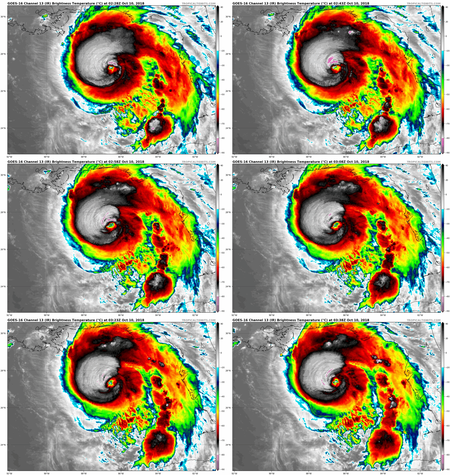
pressures falls occurring during the past few hours. Michael's eye
has become more distinct in GOES-16 high-resolution infrared
satellite imagery, with a solid ring of cloud top temperatures
colder than -75 deg C surrounding the warming eye. Some cloud tops
in the eyewall have been as cold as -88C, which is very impressive
for a Gulf system. The peak 8000-ft flight-level winds measured by
the NOAA aircraft thus far has been 130 kt and the strongest SFMR
surface wind speed observed has been 110 kt in the same location as
the peak flight-level winds. Based on these wind data, along with a
central pressure of 947 mb, Michael's intensity has been increased
to 110 kt. Satellite intensity estimates from TAFB and SAB, along
with objective estimates from UW-CIMSS ADT and NHC, support an
intensity of 115-127 kt. However, those also estimates also would
support a central pressure of about 935 mb, which the aircraft has
not measured thus far.

The initial motion estimate is due north, or 360/10 kt. Michael is
essentially on the previous advisory track, and there is no
significant change to the previous track forecast discussion. The
models have settled in a stable forecast pattern, which calls for
Michael to remain embedded within deep southerly flow for the next
24 hours between a  substantial ridge to the east and a highly
amplified mid-latitude trough moving eastward across the western and
central U.S. and northern Mexico. As a result, the dangerous
hurricane is expected to move northward to north-northeastward and
make landfall along the coast of the central panhandle of Florida by
late Wednesday afternoon. After landfall, increasing southwesterly
flow ahead of the approaching deep-layer trough is expected to
accelerate Michael toward the northeast through 48 h, with the
cyclone moving across the southeastern U.S. late Wednesday and
Thursday, and emerging over the western Atlantic by early Friday. A
continued northeastward motion at forward speeds of 30-40 kt is
forecast at 72-120 h when Michael is expected to be an extratropical
cyclone. The new NHC forecast track is essentially just an update of
the previous advisory track, and lies close to the tightly packed
consensus models TVCN, TVCX, TCON, and NOAA-HCCA.

Similar to the previous advisory, the environment ahead of Michael
is expected to remain conducive for additional strengthening until
landfall occurs due to SSTs of at least 85 deg F beneath the
hurricane, combined with decreasing vertical wind shear along with
the shear vector shifting from current west-northwesterly to a less
hostile southwesterly component, which will be more along Michael's
forecast track. As a result, Michael is now explicitly forecast to
become a category 4 hurricane before landfall occurs. After
landfall, significant weakening is expected while Michael moves over
the southeastern United States, but the cyclone is forecast to
re-strengthen over the western Atlantic due to baroclinic forcing
after it merges with a front and becomes extratropical on Friday.
The new intensity forecast closely follows a blend of the IVCN,
HCCA, and FSSE consensus models throughout the 120-h period.

Tropical storm conditions are expected to reach the hurricane
warning area by Wednesday morning, so all preparations should be
rushed to completion.

Key Messages:

1. Life-threatening storm surge is likely along portions of the
coasts of the Florida Panhandle, Big Bend, and Nature Coast, where
a storm surge warning is in effect. The worst storm surge is
expected between Mexico Beach and Keaton Beach, where 9 to 13 feet
of inundation is possible. Water levels will rise well in advance of
the center of Michael, and residents within the storm surge warning
area should finish preparations to protect life and property today.

2. Everyone in the hurricane warning area along the Florida Gulf
Coast should prepare for life-threatening major hurricane winds
associated with the core of Michael. Hurricane force winds will also
extend well inland across portions of the Florida Panhandle,
southern Georgia, and southeast Alabama as Michael moves inland.

3. Heavy rainfall from Michael could produce life-threatening flash
flooding from the Florida Panhandle and Big Bend region into
portions of Georgia, the Carolinas, and southeast Virginia.

4. Tropical storm conditions will likely affect portions of the
southeast U.S. coast from northeast Florida through North Carolina,
and tropical storm watches and warnings are in effect for these
areas.


FORECAST POSITIONS AND MAX WINDS

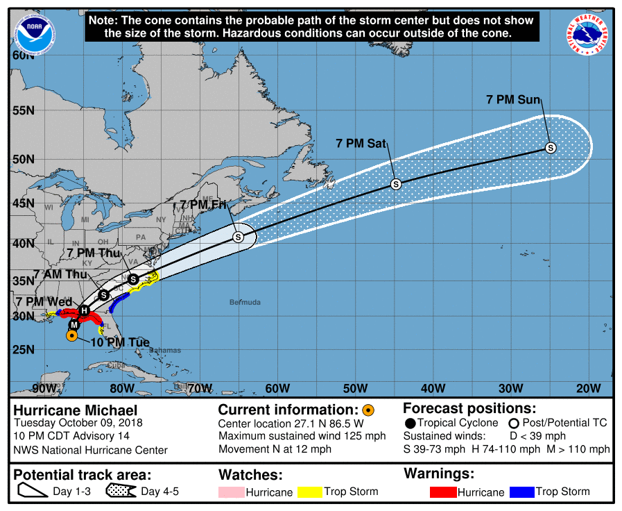
INIT  10/0300Z 27.1N  86.5W  110 KT 125 MPH
12H  10/1200Z 28.7N  86.2W  115 KT 130 MPH
24H  11/0000Z 30.8N  84.9W   70 KT  80 MPH...INLAND
36H  11/1200Z 33.0N  82.4W   40 KT  45 MPH...INLAND
48H  12/0000Z 35.2N  78.6W   40 KT  45 MPH...INLAND
72H  13/0000Z 40.8N  65.1W   50 KT  60 MPH...POST-TROP/EXTRATROP
96H  14/0000Z 47.2N  44.8W   55 KT  65 MPH...POST-TROP/EXTRATROP
120H  15/0000Z 51.2N  24.9W   45 KT  50 MPH...POST-TROP/EXTRATROP

$$
Forecaster Stewart
033350_5day_cone_with_line.png

goes16_ir_14L.gif

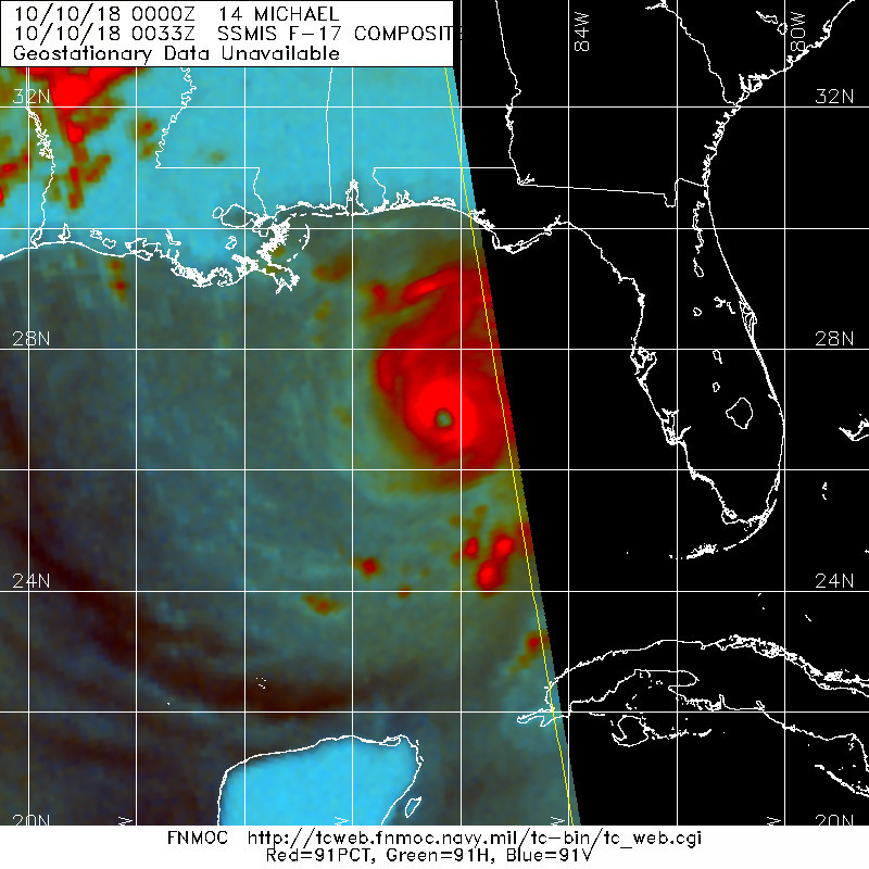
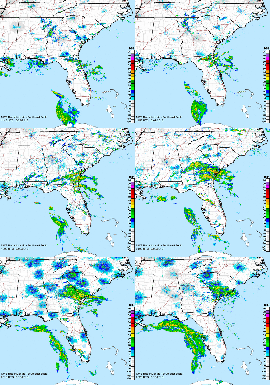
20181010.0033.f17.91pct91h91v.14L.MICHAEL.110kts.949mb.26.6N.86.5W.060pc.jpg

Michael_9-10Oct18_southeast.gif
回復

使用道具 舉報

簽到天數: 3291 天

[LV.Master]伴壇終老

t02436|2018-10-10 17:10 | 顯示全部樓層
09Z評價120節,C4正式達成!
000
WTNT44 KNHC 100854
TCDAT4

Hurricane Michael Discussion Number  15
NWS National Hurricane Center Miami FL       AL142018
400 AM CDT Wed Oct 10 2018

Reports from an Air Force Reserve Hurricane Hunter aircraft
indicate that Michael has continued to strengthen during the past
several hours.  The maximum flight-level winds at 700 mb have been
136 kt, and the maximum surface wind estimates from the Stepped
Frequency Microwave Radiometer are in the 120-125 kt range.  In
addition, the central pressure has fallen to near 943 mb.  Based on
on the aircraft data, the initial intensity is increased to 120 kt.
This is a little below the satellite intensity estimates from TAFB,
SAB, and the CIMSS satellite consensus.  The cirrus outflow
associated with Michael has improved over the past several hours,
with the outflow flowing into an upper-level low to the southeast
and along the east side of a large mid-latitude trough to the west.

The initial motion is 360/11.  Michael is embedded in the flow
between a large mid- to upper-level ridge over the western Atlantic
and the northeastern United States and the aforementioned trough
across the central United States.  These features should cause the
hurricane to turn north-northeastward during the next 12 h or so,
followed by a turn toward the northeast and a significant increase
in forward speed.  Near the end of the forecast period, Michael or
its remnants should turn more eastward. The forecast track calls for
the eye to make landfall in the Florida Panhandle at about the 12 h
point, followed by a northeastward motion across the southeastern
United States between 12-48 h.  The forecast guidance remains
tightly clustered, and the new forecast track is very close to the
previous track and the various consensus models through 72 h.

Additional strengthening is expected before landfall as Michael
remains over warm water and in an environment of light to moderate
vertical shear.  After landfall, Michael is expected to steadily
weaken as it crosses the southeastern United States.  Extratropical
transition is expected to begin while Michael is over land, and
this should be complete just after the 48 h point.  The cyclone
should re-intensify due to baroclinic forcing as it moves rapidly
northeastward over the north Atlantic.  The new intensity forecast
has been nudged upward at the landfall time based on current
trends.  Otherwise, it is an update of the previous forecast.

Tropical storm conditions are expected to reach the hurricane
warning area during the next few hours, so all preparations should
be rushed to completion.

Key Messages:

1. Life-threatening storm surge is likely along portions of the
coasts of the Florida Panhandle, Big Bend, and Nature Coast, where
a storm surge warning is in effect. The worst storm surge is
expected between Tyndall Air Force Base and Keaton Beach, where 9 to
13 feet of inundation is possible.

2. Michael is likely to produce potentially catastrophic wind
damage where the core of the hurricane moves onshore in the Florida
Panhandle, and everyone in the hurricane warning area should
prepare for life-threatening hurricane winds.  Dangerous hurricane-
force winds will also extend well inland across portions of the
Florida Panhandle, southern Georgia, and southeast Alabama as
Michael moves inland.

3. Heavy rainfall from Michael could produce life-threatening flash
flooding from the Florida Panhandle and Big Bend region into
portions of Georgia, the Carolinas, and southeast Virginia.

4. Tropical storm conditions will likely affect portions of the
southeast U.S. coast from northeast Florida through North Carolina,
and tropical storm watches and warnings are in effect for these
areas.


FORECAST POSITIONS AND MAX WINDS

INIT  10/0900Z 28.3N  86.5W  120 KT 140 MPH
12H  10/1800Z 29.9N  85.7W  125 KT 145 MPH
24H  11/0600Z 32.1N  83.8W   65 KT  75 MPH...INLAND
36H  11/1800Z 34.4N  80.5W   40 KT  45 MPH...INLAND
48H  12/0600Z 36.8N  75.6W   40 KT  45 MPH...OVER WATER
72H  13/0600Z 43.5N  59.5W   50 KT  60 MPH...POST-TROP/EXTRATROP
96H  14/0600Z 49.5N  36.0W   55 KT  65 MPH...POST-TROP/EXTRATROP
120H  15/0600Z 52.0N  17.5W   45 KT  50 MPH...POST-TROP/EXTRATROP

$$
Forecaster Beven

033350_5day_cone_with_line.png

ff7f8843-f541-42ea-abb7-7ac273c45d6c.gif

Michael_9-10Oct18_EVX_long.gif

recon_AF306-1314A-MICHAEL_timeseries.png
回復

使用道具 舉報

123下一頁
快速回覆
您需要登錄後才可以回帖 登錄 | 立即加入

本版積分規則

霧峰追風者

    主題

    帖子

    221萬

    積分

    16級[四級颶風]

    Rank: 16Rank: 16Rank: 16Rank: 16

16級[四級颶風]

發訊息

本平台僅供學術討論之用,預報應以氣象局為準

威普網站虛擬主機贊助公司

臺灣第一個天氣類型社群平台 即時天氣資訊、精準颱風動態

線上客服
FB傳送訊息
廣告行銷
精準行銷 物超所值
官方粉專
發佈 快速回復 返回頂部 返回列表