開啟輔助訪問
 找回密碼
 立即加入

14U(03S) 橫越西北澳 風力達標但無閉合環流未命名

簽到天數: 2414 天

[LV.Master]伴壇終老

2017-1-23 15:26 | 顯示全部樓層
  熱帶低壓  
編號:14 U ( 03 S )
名稱:
03S.jpg

  基本資料     
擾動編號日期:2017 01 23 14
JTWC升格日期:2017 01 27 14
撤編日期  :2017 02 03 02
登陸地點  :

  巔峰時期資料  
近中心最強風速 /海平面最低氣壓
澳洲氣象局 (BoM) :  45 kt
聯合颱風警報中心(JTWC): 45 kt ( TS )
海平面最低氣壓    :988 百帕

  過去路徑圖  
TWTYBBS_03S(14U)_UNNAMED_TRACK_t02436_TWTYBBS.png

  討論帖圖片  
90P.INVEST.15kts.1010mb.14.3S.136.7E

20170123.0630.himawari-8.vis.90P.INVEST.15kts.1010mb.14.3S.136.7E.100pc.jpg

以上資料來自:BoM、JTWC、颱風論壇整理製作

評分

參與人數 1水氣能量 +15 +1 收起 理由
king111807 + 15 + 1 熱帶擾動首帖

查看全部評分

回復

使用道具 舉報

簽到天數: 3279 天

[LV.Master]伴壇終老

t02436|2017-1-28 10:38 | 顯示全部樓層
BoM 18Z評價35節,00Z再根據南方島嶼實測資料調升評價至45節,只是還不肯命名。
IDW27600
TROPICAL CYCLONE TECHNICAL BULLETIN: AUSTRALIA - WESTERN REGION
Issued by PERTH TROPICAL CYCLONE WARNING CENTRE
at: 0106 UTC 28/01/2017
Name: Tropical Low  
Identifier: 14U
Data At: 0000 UTC
Latitude: 20.0S
Longitude: 114.9E
Location Accuracy: within 30 nm [55 km]
Movement Towards: west southwest [246 deg]
Speed of Movement: 15 knots [29 km/h]
Maximum 10-Minute Wind: 45 knots [85 km/h]
Maximum 3-Second Wind Gust: 65 knots [120 km/h]
Central Pressure: 990 hPa
Radius of 34-knot winds NE quadrant:   
Radius of 34-knot winds SE quadrant: 100 nm [185 km]
Radius of 34-knot winds SW quadrant: 100 nm [185 km]
Radius of 34-knot winds NW quadrant:   
Radius of 48-knot winds NE quadrant:   
Radius of 48-knot winds SE quadrant:   
Radius of 48-knot winds SW quadrant:   
Radius of 48-knot winds NW quadrant:   
Radius of 64-knot winds:   
Radius of Maximum Winds:   
Dvorak Intensity Code: T2.0/2.0/S0.0/24HRS STT:S0.0/06HRS
Pressure of outermost isobar: 1000 hPa
Radius of outermost closed isobar: 200 nm [370 km]
FORECAST DATA
Date/Time    : Location    : Loc. Accuracy: Max Wind   : Central Pressure
[UTC]        : degrees     :      nm  [km]: knots[km/h]: hPa
+06:  28/0600: 20.2S 113.6E:     040 [080]:  045  [085]:  986
+12:  28/1200: 20.4S 112.7E:     065 [120]:  045  [085]:  985
+18:  28/1800: 20.4S 111.7E:     075 [140]:  050  [095]:  982
+24:  29/0000: 20.5S 111.0E:     085 [155]:  050  [095]:  981
+36:  29/1200: 20.8S 109.7E:     100 [180]:  040  [075]:  988
+48:  30/0000: 21.1S 107.6E:     120 [220]:  035  [065]:  992
+60:  30/1200: 21.7S 106.1E:     140 [255]:  030  [055]:  994
+72:  31/0000: 22.5S 104.3E:     155 [290]:  030  [055]:  995
+96:  01/0000: 23.7S 100.6E:     200 [370]:  030  [055]:  994
+120: 02/0000: 23.6S  95.2E:     290 [535]:  025  [045]:  998
REMARKS:The centre of the tropical low is estimated using a combination the Port
Hedland and Dampier radars along with surface wind observations.

There appears to be multiple weak vorticies around a broader circulation.

DVORAK analysis was performed using a curved band pattern which gave a wrap of
around 0.4. The system has been assessed as standard development [D] over the
last 24hrs so the MET is 2.5, but it restricted by the PAT. FT and CI is 2.0.

Intensity is set at 45 knots and this is confirmed by several mean wind
observations of 40-45 knots at Barrow Island and also other locations just
offshore of the Pilbara coastline. Although those winds are likely to be only
limited to the southern side of the system due to the fast translation speed to
the west southwest and also an increased pressure gradient between the system
and a high pressure system over central Australia.

The environment is generally favourable for development. Wind shear from CIMSS
is easterly 10 to 15 knots and also similar results from other numerical weather
guidance. There is abundant moisture feeding into this system and there are
outflow channels evident, mainly to the north. The system is forecast to develop
into a tropical cyclone within the next 12 hours. The system is then expected to
encounter cooler sea surface temperatures in the next 24-36 hours which may
further hinder its development.

NWP guidance remains consistent keeping the tracks and speed of the system
clustered about the current forecast solution. Recent motion has been relatively
fast, around 15 knots toward the west southwest, and the system is expected to
continue in this direction as it is under the influence of a strong mid-level
ridge to the south.

Winds and waves on the southern side will be enhanced due to the system's
translation speed and ridge to the south.

Copyright Commonwealth of Australia
==
The next bulletin for this system will be issued by: 28/0730 UTC by Perth TCWC.

IDW60280.png

vis-animated.gif
回復

使用道具 舉報

簽到天數: 3279 天

[LV.Master]伴壇終老

t02436|2017-1-27 20:19 | 顯示全部樓層
JTWC 06Z已經升格03S,但巔峰僅預測到40節為止。

sh0317.gif

rbtop-animated.gif

回復

使用道具 舉報

簽到天數: 4444 天

[LV.Master]伴壇終老

s6815711|2017-1-27 12:06 | 顯示全部樓層
18Z評級提升至High
(1) THE AREA OF CONVECTION (INVEST 90P) PREVIOUSLY LOCATED
NEAR 15.8S 126.8E, IS NOW LOCATED NEAR 17.1S 121.9E, APPROXIMATELY
540 NM NORTHEAST OF LEARMONTH, AUSTRALIA. ANIMATED ENHANCED INFRARED
SATELLITE IMAGERY AND A 261032Z SSMIS 91GHZ PARTIAL MICROWAVE PASS
SHOW A WELL DEFINED LOW LEVEL CIRCULATION CENTER ASSOCIATED WITH A
LARGE AREA OF CONVECTION MOVING OVER LAND TOWARDS THE WEST COAST OF
AUSTRALIA. THE DISTURBANCE IS CURRENTLY LOCATED IN A FAVORABLE
ENVIRONMENT WITH SEA SURFACE TEMPERATURES NEAR 31 DEGREES CELSIUS,
LOW VERTICAL WIND SHEAR (10 KNOTS), AND GOOD UPPER LEVEL DIVERGENCE.
GLOBAL MODELS ARE IN AGREEMENT THAT THE DISTURBANCE WILL TRACK TO
THE WEST-SOUTHWEST WITH CONTINUED CONSOLIDATION AND INTENSIFICATION
OVER THE NEXT SEVERAL DAYS.  MAXIMUM SUSTAINED SURFACE WINDS ARE
ESTIMATED AT 25 TO 30 KNOTS. MINIMUM SEA LEVEL PRESSURE IS ESTIMATED
TO BE NEAR 998 MB. THE POTENTIAL FOR THE DEVELOPMENT OF A
SIGNIFICANT TROPICAL CYCLONE WITHIN THE NEXT 24 HOURS REMAINS
HIGH. SEE REF A (WTXS21 PGTW 261400) FOR FURTHER DETAILS.
abiosair.jpg

回復

使用道具 舉報

簽到天數: 3279 天

[LV.Master]伴壇終老

t02436|2017-1-26 22:53 | 顯示全部樓層
JTWC  14Z發布TCFA,已經認定中心在海上了。
WTXS21 PGTW 261400
MSGID/GENADMIN/JOINT TYPHOON WRNCEN PEARL HARBOR HI//
SUBJ/TROPICAL CYCLONE FORMATION ALERT//
RMKS/
1. FORMATION OF A SIGNIFICANT TROPICAL CYCLONE IS POSSIBLE WITHIN
180 NM EITHER SIDE OF A LINE FROM 17.1S 122.4E TO 18.7S 116.6E
WITHIN THE NEXT 12 TO 24 HOURS. AVAILABLE DATA DOES NOT JUSTIFY
ISSUANCE OF NUMBERED TROPICAL CYCLONE WARNINGS AT THIS TIME.
WINDS IN THE AREA ARE ESTIMATED TO BE 25 TO 30 KNOTS. METSAT
IMAGERY AT 261200Z INDICATES THAT A CIRCULATION CENTER IS LOCATED
NEAR 17.1S 121.9E. THE SYSTEM IS MOVING WESTWARD AT 12 KNOTS.
2. REMARKS: THE AREA OF CONVECTION (INVEST 90P) PREVIOUSLY LOCATED
NEAR 15.8S 126.8E, IS NOW LOCATED NEAR 17.1S 121.9E, APPROXIMATELY
540 NM NORTHEAST OF LEARMONTH, AUSTRALIA. ANIMATED ENHANCED INFRARED
SATELLITE IMAGERY AND A 261032Z SSMIS 91GHZ PARTIAL MICROWAVE PASS
SHOW A WELL DEFINED LOW LEVEL CIRCULATION CENTER ASSOCIATED WITH A
LARGE AREA OF CONVECTION MOVING OVER LAND TOWARDS THE WEST COAST OF
AUSTRALIA. THE DISTURBANCE IS CURRENTLY LOCATED IN A FAVORABLE
ENVIRONMENT WITH SEA SURFACE TEMPERATURES NEAR 31 DEGREES CELSIUS,
LOW VERTICAL WIND SHEAR (10 KNOTS), AND GOOD UPPER LEVEL DIVERGENCE.
GLOBAL MODALS ARE IN AGREEMENT THAT THE DISTURBANCE WILL TRACK TO
THE WEST-SOUTHWEST WITH CONTINUED CONSOLIDATION AND INTENSIFICATION
OVER THE NEXT SEVERAL DAYS. MAXIMUM SUSTAINED SURFACE WINDS ARE
ESTIMATED AT 25 TO 30 KNOTS. MINIMUM SEA LEVEL PRESSURE IS ESTIMATED
TO BE NEAR 998 MB. THE POTENTIAL FOR THE DEVELOPMENT OF A
SIGNIFICANT TROPICAL CYCLONE WITHIN THE NEXT 24 HOURS IS HIGH.
3. THIS ALERT WILL BE REISSUED, UPGRADED TO WARNING OR CANCELLED BY
271400Z.//
NNNN

sh9017.gif
回復

使用道具 舉報

簽到天數: 3279 天

[LV.Master]伴壇終老

t02436|2017-1-26 21:59 | 顯示全部樓層
正式編號14U,不過並不看好發展。
IDW27600
TROPICAL CYCLONE TECHNICAL BULLETIN: AUSTRALIA - WESTERN REGION
Issued by PERTH TROPICAL CYCLONE WARNING CENTRE
at: 1329 UTC 26/01/2017
Name: Tropical Low  
Identifier: 14U
Data At: 1200 UTC
Latitude: 17.6S
Longitude: 122.6E
Location Accuracy: within 50 nm [95 km]
Movement Towards: west southwest [240 deg]
Speed of Movement: 13 knots [24 km/h]
Maximum 10-Minute Wind: 15 knots [30 km/h]
Maximum 3-Second Wind Gust: 45 knots [85 km/h]
Central Pressure: 998 hPa
Radius of 34-knot winds NE quadrant:   
Radius of 34-knot winds SE quadrant:   
Radius of 34-knot winds SW quadrant:   
Radius of 34-knot winds NW quadrant:   
Radius of 48-knot winds NE quadrant:   
Radius of 48-knot winds SE quadrant:   
Radius of 48-knot winds SW quadrant:   
Radius of 48-knot winds NW quadrant:   
Radius of 64-knot winds:   
Radius of Maximum Winds:   
Dvorak Intensity Code: NA
Pressure of outermost isobar: 1002 hPa
Radius of outermost closed isobar: 150 nm [280 km]
FORECAST DATA
Date/Time    : Location    : Loc. Accuracy: Max Wind   : Central Pressure
[UTC]        : degrees     :      nm  [km]: knots[km/h]: hPa
+06:  26/1800: 17.8S 121.4E:     060 [115]:  020  [035]:  998
+12:  27/0000: 17.9S 120.0E:     075 [135]:  030  [055]:  998
+18:  27/0600: 18.2S 119.0E:     085 [160]:  035  [065]:  996
+24:  27/1200: 18.6S 117.9E:     100 [185]:  040  [075]:  992
+36:  28/0000: 19.5S 115.3E:     120 [220]:  045  [085]:  989
+48:  28/1200: 20.0S 112.7E:     140 [255]:  045  [085]:  988
+60:  29/0000: 20.1S 110.8E:     160 [295]:  045  [085]:  987
+72:  29/1200: 20.4S 109.3E:     175 [330]:  040  [075]:  990
+96:  30/1200: 21.0S 105.7E:     220 [410]:  035  [065]:  992
+120: 31/1200: 21.9S 101.7E:     310 [570]:  030  [055]:  997
REMARKS:
The centre of the tropical low was found using a combination of satellite and
Broome Radar. The location was difficult to identify due to squally
thunderstorms over the area. Surrounding observations were affected by
thunderstorms.

The tropical low lies over land so no DVORAK analysis; however, general
convection shows good curvature.

As the low moves offshore some time in the next 6 hours it enters an environment
favourable for development. There is abundant moisture feeding into this system
and there are outflow channels evident, mainly to the north. Wind shear is
estimated as an ESE'ly 10 to 15 knots from CIMMS.

This system will continue to take a west-southwesterly track parallel to the
coast under the steering of a mid level ridge. Intensity of the forecast track
is limited to 45 knots and generally model guidance fails to intensify the
system significantly before it encounters cooler SST. Winds on the southern side
will be enhanced due to the system's translation speed and ridge to the south.
There is a risk the system may reach Category 2 intensity.

Copyright Commonwealth of Australia
==
The next bulletin for this system will be issued by: 26/1930 UTC by Perth TCWC.

IDW60280.png

rbtop-animated.gif
回復

使用道具 舉報

簽到天數: 4444 天

[LV.Master]伴壇終老

s6815711|2017-1-26 06:28 | 顯示全部樓層
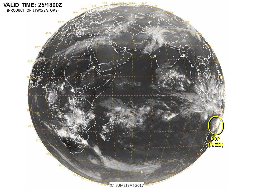
評級提升至Medium
(1) THE AREA OF CONVECTION (INVEST 90P) PREVIOUSLY LOCATED
NEAR 15.6S 127.2E, IS NOW LOCATED NEAR 15.8S 126.8E, APPROXIMATELY
290 NM EAST-NORTHEAST OF BROOME, AUSTRALIA. ANIMATED ENHANCED
SATELLITE IMAGERY AND A 251338Z MHS METOP-B 89GHZ MICROWAVE PASS
DEPICT DEEP FLARING CONVECTION AND FORMATIVE BANDING BEGINNING TO
CONSOLIDATE ABOUT THE BROAD LOW LEVEL CIRCULATION, EVIDENT IN THE
512KM WYNDHAM COMPOSITE RADAR LOOP. UPPER LEVEL ANALYSIS INDICATES
MODERATE EQUATORWARD OUTFLOW WITH LOW TO MODERATE (10-20 KNOT)
VERTICAL WIND SHEAR. ALTHOUGH THE CYCLONIC CIRCULATION REMAINS OVER
LAND, GLOBAL MODEL GUIDANCE SHOW A WEST-SOUTHWESTWARD TRACK OVER
NORTHWESTERN AUSTRALIA BEFORE EXITING OVER WARM WATERS (29C) WITHIN
6 TO 12 HOURS, WHICH WILL ALLOW FOR FURTHER DEVELOPMENT. MAXIMUM
SUSTAINED SURFACE WINDS ARE ESTIMATED AT 20 TO 25 KNOTS. MINIMUM SEA
LEVEL PRESSURE IS ESTIMATED TO BE NEAR 1003 MB. BASED ON IMPROVED
STRUCTURE AND FAVORABLE SSTS, THE POTENTIAL FOR THE DEVELOPMENT OF A
SIGNIFICANT TROPICAL CYCLONE WITHIN THE NEXT 24 HOURS IS UPGRADED TO
MEDIUM.
abiosair.jpg

回復

使用道具 舉報

簽到天數: 3279 天

[LV.Master]伴壇終老

t02436|2017-1-25 15:31 | 顯示全部樓層
BoM開始發報,預測3天後命名。
TROPICAL CYCLONE ADVICE NUMBER 1
Issued at 2:49 pm WST on Wednesday 25 January 2017
Headline:
Tropical low moving across Kimberley may develop into a tropical cyclone late Friday or Saturday north of Pilbara.

Areas Affected:
Warning Zone
None.

Watch Zone
Bidyadanga to Mardie.

Cancelled Zone
None.

Details of Tropical Low at 2:00 pm AWST:
Intensity: Tropical Low, sustained winds near the centre of 35 kilometres per hour with wind gusts to 85 kilometres per hour.

Location: within 55 kilometres of 15.8 degrees South 127.9 degrees East, estimated to be 45 kilometres south southwest of Wyndham and 90 kilometres west of Kununurra.

Movement: west at 14 kilometres per hour.

A tropical low will move towards the west southwest across the Kimberley during Wednesday and Thursday. The low is expected to move offshore from the west Kimberley coast late Thursday or early Friday. The low will gradully strengthen and may develop into a tropical cyclone late Friday or during Saturday as it tracks north of and generally parallel to the Pilbara coast.

Hazards:
Ahead of and prior to the system becoming a tropical cyclone, squally thunderstorms are possible along the west Kimberley and Pilbara coasts.

GALES with gusts to 100 kilometres per hour may develop in coastal parts between Bidyadanga and Mardie on Friday evening or during Saturday.

Further heavy rainfall and flooding is likely over the Kimberley and a Severe Weather Warning and Flood Watches/Warnings are current. For further details please refer to http://www.bom.gov.au/wa/warnings/. Heavy rainfall will extend to coastal parts of the Pilbara from Friday.

Recommended Action:
DFES advises that there are no community alerts at present.

Communities between Bidyadanga and Mardie should listen for the next advice.

Next Advice:
The next advice will be issued by 9:00 pm AWST Wednesday 25 January.
Cyclone advices and DFES Alerts are available by dialling 13 DFES (13 3337)

IDW60280.png

90P_gefs_latest.png

rbtop-animated.gif

回復

使用道具 舉報

12下一頁
快速回覆
您需要登錄後才可以回帖 登錄 | 立即加入

本版積分規則

本平台僅供學術討論之用,預報應以氣象局為準

威普網站虛擬主機贊助公司

臺灣第一個天氣類型社群平台 即時天氣資訊、精準颱風動態

線上客服
FB傳送訊息
廣告行銷
精準行銷 物超所值
官方粉專
發佈 快速回復 返回頂部 返回列表