開啟輔助訪問
 找回密碼
 立即加入

11L.Irma 橫颳大西洋 逐漸消亡

簽到天數: 969 天

[LV.10]以壇為家III

kbty245|2017-9-6 01:00 | 顯示全部樓層
颶風獵人的最新實測

00
URNT15 KNHC 051639
AF309 0811A IRMA               HDOB 46 20170905
162930 1710N 05832W 6968 02929 9836 +074 +074 131128 130 092 030 00
163000 1709N 05833W 6965 02915 9817 +078 +078 130132 134 098 052 00
163030 1708N 05835W 6960 02902 9775 +095 +095 136128 132 110 029 00
163100 1707N 05836W 6979 02837 9735 +099 +099 136129 130 116 014 00
163130 1706N 05837W 6969 02825 9698 +099 +099 134135 137 121 021 03
163200 1705N 05838W 6962 02797 9664 +098 +098 133142 143 122 027 03
2163230 1704N 05839W 6965 02754 9623 +099 +099 134145 150 136 075 00
163300 1703N 05840W 6973 02711 9573 +106 +106 138145 151 147 066 00
163330 1702N 05841W 6961 02668 9504 +115 +115 139132 141 160 046 00
163400 1701N 05842W 6962 02616 /////   +109   //// 137121 133 160 024 05
163430 1700N 05843W 6956 02574 9331 +145 +140 140102 115 ///// //// 03
163500 1659N 05844W 6979 02525 9293 +174 +146 143085 093 121 001 03
163530 1658N 05845W 6957 02529 9262 +179 +147 148070 081 082 001 03
163600 1657N 05846W 6976 02491 9240 +192 +141 150048 063 067 000 00
163630 1656N 05848W 6970 02487 9240 +179 +139 155037 043 058 001 03
163700 1655N 05849W 6963 02490 9235 +175 +133 162024 034 040 003 00
163730 1654N 05851W 6961 02491 9235 +174 +131 153010 018 030 001 00
163800 1653N 05853W 6965 02485 9237 +172 +127 055002 005 026 000 00
163830 1652N 05854W 6967 02484 9239 +173 +126 332010 014 029 000 00
163900 1652N 05856W 6965 02490 9247 +169 +128 321015 016 029 001 03
$$


海平面最大風速160kts!!!


最低氣壓第一次穿心時是估計923.5hpa


第二次穿心是估計922.6hpa


不過真正的氣壓要等投落送資料出來
回復

使用道具 舉報

簽到天數: 588 天

[LV.9]以壇為家II

Meow|2017-9-5 23:08 | 顯示全部樓層
加勒比海、墨西哥灣以外北大西洋最強颶風
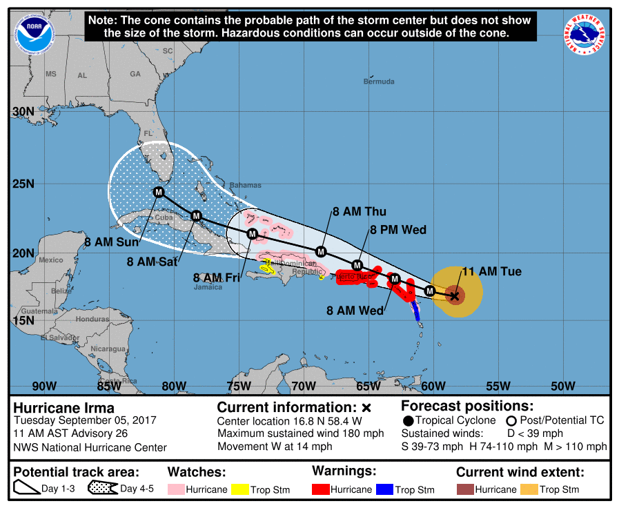
145233_5day_cone_with_line_and_wind.png
000
WTNT41 KNHC 051446
TCDAT1

Hurricane Irma Discussion Number  26
NWS National Hurricane Center Miami FL       AL112017
1100 AM AST Tue Sep 05 2017

Irma is an extremely impressive hurricane in both infrared and
visible satellite images.  Experimental GOES-16 one-minute visible
satellite pictures show a distinct 25-30 n mi wide eye with several
mesovortices rotating within with eye.  The aircraft have not
sampled the northeastern eyewall where the strongest winds were
measured shortly before 1200 UTC this morning, but the Air Force
plane will be entering the eye in that quadrant momentarily.  A peak
SFMR wind of 154 kt was reported, with a few others of 149-150 kt.
Based on these data the initial intensity is set at 155 kt for this
advisory. This makes Irma the strongest hurricane in the Atlantic
basin outside of the Caribbean Sea and Gulf of Mexico in the NHC
records.

Irma is expected to remain within low vertical wind shear, a moist
mid-level atmosphere, and high upper-ocean heat content as it moves
west-northwestward during the next several days. These conditions
should allow the hurricane to remain very intense throughout much
of the forecast period, however, fluctuations in intensity are
likely to occur as eyewall replacement cycles take place.  The NHC
intensity forecast is near the upper-end of the guidance and assumes
little overall interaction of Irma with the islands of the Greater
Antilles.

Irma continues to move westward at about 12 kt, and a strong
subtropical ridge centered over the central Atlantic should steer
Irma generally westward today. The ridge is expected to remain in
place over the western Atlantic during the next several days and
Irma is forecast to move west-northwestward throughout the most of
remainder of the forecast period.  Around day 5, a shortwave trough
dropping southward over the central United States is expected to
begin eroding the western portion of the ridge, allowing a Irma to
gain some latitude.  The new NHC track forecast is close to the
HFIP corrected consensus model and is very similar to the previous
forecast.

Since Irma is a large hurricane, users are reminded to not focus on
the exact forecast track since tropical-storm and hurricane-force
winds and life-threatening storm surge extend far from the center.
Residents in the Leeward Islands should complete their preparations
very soon as the weather will begin to deteriorate over the
easternmost Leeward Islands later this afternoon.


KEY MESSAGES:

1. Irma is a potentially catastrophic category 5 hurricane and will
bring life-threatening wind, storm surge, and rainfall hazards to
portions of the northeastern Leeward Islands beginning later today
and the Virgin Islands and Puerto Rico beginning tomorrow.
Preparations should be rushed to completion before the arrival of
tropical-storm force winds later today in the Leeward Islands and
tomorrow morning in Virgin Islands and Puerto Rico.

2. Hurricane watches have been issued for portions of the Dominican
Republic and Haiti, the southeastern Bahamas and Turks and Caicos,
and Irma could bring dangerous wind, storm surge, and rainfall to
those areas on Thursday and Friday.

3. Irma could directly affect the remainder of the Bahamas and Cuba
as an extremely dangerous major hurricane later this week. Residents
in these areas should monitor the progress of Irma and listen to
advice given by officials.

4. The chance of direct impacts from Irma later this week and this
weekend is increasing in the Florida Keys and portions of the
Florida Peninsula. However, it is too soon to specify the timing
and magnitude of the impacts. Elsewhere, it is too early to
determine what direct impacts Irma might have on the continental
United States. Everyone in hurricane-prone areas should ensure that
they have their hurricane plan in place.

FORECAST POSITIONS AND MAX WINDS

INIT  05/1500Z 16.8N  58.4W  155 KT 180 MPH
12H  06/0000Z 17.2N  60.3W  155 KT 180 MPH
24H  06/1200Z 18.1N  63.0W  150 KT 175 MPH
36H  07/0000Z 19.1N  65.9W  145 KT 165 MPH
48H  07/1200Z 20.1N  68.7W  140 KT 160 MPH
72H  08/1200Z 21.4N  74.0W  135 KT 155 MPH
96H  09/1200Z 22.7N  78.3W  130 KT 150 MPH
120H  10/1200Z 24.4N  81.2W  125 KT 145 MPH

$$
Forecaster Brown

評分

參與人數 1水氣能量 +3 收起 理由
b997755 + 3 可惜沒懸臂,不然就又美又強了.

查看全部評分

回復

使用道具 舉報

簽到天數: 3279 天

[LV.Master]伴壇終老

t02436|2017-9-5 22:48 | 顯示全部樓層
升上C5第一報正報,評價150節,上望155節。
000
WTNT41 KNHC 051200
TCDAT1

Hurricane Irma Special Discussion Number  25
NWS National Hurricane Center Miami FL       AL112017
800 AM AST Tue Sep 05 2017

This special advisory is being issued to increase the initial and
forecast intensity of Irma.

NOAA and U.S. Air Force Hurricane Hunter aircraft have recently
measured peak flight-level winds of around 170 kt and SFMR winds
of around 150 kt. Based on these data the initial intensity has
been increased to 150 kt, making Irma an extremely dangerous
category 5 hurricane.
Some additional strengthening is still
possible, but fluctuations in intensity are likely during the next
couple of days due to eyewall replacement cycles.

No change was made to the previous track or wind radii forecast.

KEY MESSAGES:

1. Irma is expected to affect the northeastern Leeward Islands as
an extremely dangerous category 5 hurricane, accompanied by
life-threatening wind, storm surge, and rainfall. Hurricane warnings
are in effect for portions of the Leeward Islands. Preparations
should be rushed to completion, as tropical-storm force winds are
expected to first arrive in the hurricane warning area later today.

2. Irma is also expected to affect the British and U.S. Virgin
Islands and Puerto Rico as a dangerous major hurricane beginning
tomorrow, with life-threatening wind, storm surge, and rainfall.
Hurricane warnings have been issued for these areas, and tropical-
storm-force winds are expected to arrive in these areas by early
tomorrow.

3. Irma could directly affect Hispaniola, the Turks and Caicos, the
Bahamas, and Cuba as an extremely dangerous major hurricane later
this week. Residents in these areas should monitor the progress of
Irma and listen to advice given by officials.

4. There is an increasing chance of seeing some impacts from Irma in
the Florida Peninsula and the Florida Keys later this week and this
weekend.  Otherwise, it is still too early to determine what direct
impacts Irma might have on the continental United States.  However,
everyone in hurricane-prone areas should ensure that they have their
hurricane plan in place.


FORECAST POSITIONS AND MAX WINDS

INIT  05/1200Z 16.7N  57.7W  150 KT 175 MPH
12H  05/1800Z 17.0N  58.9W  155 KT 180 MPH
24H  06/0600Z 17.7N  61.5W  150 KT 175 MPH
36H  06/1800Z 18.6N  64.2W  145 KT 165 MPH
48H  07/0600Z 19.6N  67.0W  140 KT 160 MPH
72H  08/0600Z 21.2N  72.5W  135 KT 155 MPH
96H  09/0600Z 22.4N  77.2W  135 KT 155 MPH
120H  10/0600Z 24.0N  81.0W  130 KT 150 MPH

$$
Forecaster Brown

120644_5day_cone_with_line.png

vis-animated.gif

補充:第三次穿心完成,評價150節合理。
144000 1657N 05804W 6980 02892 9801 +091 //// 160130 134 103 021 05
144030 1656N 05805W 6969 02880 9773 +096 +096 163133 137 107 039 03
144100 1656N 05806W 6968 02854 9741 +098 +098 162138 141 105 065 03
144130 1655N 05807W 6951 02854 9720 +098 +098 160138 140 123 062 03
144200 1655N 05809W 6979 02791 9681 +102 +102 161140 142 122 073 03
144230 1654N 05810W 6963 02782 9645 +106 +106 161136 141 146 070 00
144300 1654N 05811W 6960 02746 9600 +111 +111 164133 135 147 067 00
144330 1653N 05812W 6979 02689 9560 +114 +114 162130 134 143 048 03
144400 1653N 05814W 6969 02661 9512 +111 //// 161128 130 147 025 01
144430 1652N 05815W 6948 02637 9460 +111 //// 159112 128 144 012 05
144500 1652N 05817W 6970 02556 9332 +131 //// 154094 101 128 001 05
144530 1651N 05819W 6970 02526 9284 +175 +143 152069 086 069 000 00
144600 1650N 05820W 6971 02504 9253 +185 +146 149046 058 063 002 03
144630 1649N 05822W 6972 02498 9236 +198 +142 149024 036 039 001 00
144700 1648N 05823W 6968 02505 9257 +176 +144 153014 017 030 000 00
144730 1648N 05825W 6973 02499 9277 +155 +145 169012 014 029 000 00
144800 1647N 05827W 6968 02505 9279 +153 +131 155013 014 027 000 03
144830 1647N 05829W 6962 02505 9264 +163 +128 149011 013 026 001 00
144900 1646N 05830W 6969 02492 9247 +179 +115 021002 009 026 001 00
144930 1644N 05832W 6964 02498 9241 +188 +101 326021 029 035 001 00
145000 1643N 05833W 6967 02510 9267 +178 +103 316048 059 055 002 03
145030 1641N 05834W 6967 02533 9306 +160 +113 313070 073 066 002 00
145100 1640N 05835W 6961 02571 9340 +147 +122 313084 088 103 002 00
145130 1639N 05837W 6978 02593 //// +119 //// 310107 121 120 001 01
145200 1638N 05838W 6971 02649 9495 +120 +120 304124 126 120 003 03
145230 1637N 05839W 6961 02701 9540 +119 +119 308124 127 110 034 00
145300 1637N 05840W 6984 02721 9592 +116 +116 310117 123 108 029 00
145330 1635N 05841W 6953 02801 9641 +107 +107 312122 126 106 027 00
145400 1634N 05842W 6967 02817 9656 +108 +094 316125 127 102 012 00
145430 1633N 05843W 6961 02861 9710 +100 +099 321115 125 099 006 00
145500 1632N 05844W 6983 02869 9745 +102 +101 323110 113 093 008 00

recon_AF309-0811A-IRMA.png

recon_AF309-0811A-IRMA_timeseries.png

評分

參與人數 1水氣能量 +20 收起 理由
ben811018 + 20

查看全部評分

回復

使用道具 舉報

簽到天數: 3279 天

[LV.Master]伴壇終老

t02436|2017-9-5 22:32 | 顯示全部樓層
馬上要進行這次(AF309 Mission #8)實測的第三次穿心,回傳資料或許將會決定15Z正報的強度是否需要調整。
recon_AF309-0811A-IRMA.png

recon_AF309-0811A-IRMA_timeseries.png

20170905.1345.goes-13.ircolor.11L.IRMA.155kts.929mb.16.7N.57.8W.100pc.jpg
回復

使用道具 舉報

簽到天數: 971 天

[LV.10]以壇為家III

jwpk9899|2017-9-5 22:07 | 顯示全部樓層
【五級颶風】大西洋的第11號颶風艾瑪(Irma),剛剛正式升格為五級颶風,並且美國最新飛機實測強度已達至少每小時280公里(150kt)的強勁風速且仍在持續增強中,加勒比海域的島國波多黎各已宣布進入緊急狀態應對颶風,預估未來颶風艾瑪南側風圈將橫掃整個加勒比海群島並於下周前期撲向剛受哈維颶風襲擊不久的美國,本周及下周有要前往加勒比海周邊國家及美國的朋友要多注意此颶風的動態!
未命名.png

回復

使用道具 舉報

簽到天數: 582 天

[LV.9]以壇為家II

蜜露|2017-9-5 21:30 | 顯示全部樓層
本帖最後由 蜜露 於 2017-9-5 21:59 編輯


目前僅只有不合格W環的伊瑪 . 居然稍早實測出 152kts  !!!!!

929hPa  152kts

問題他才929hPa,就已經有著比薔蜜還要強的風速

2017AL11_4KMIRIMG_201709051245.GIF

底層可以看出是一個Cat.5才有的 .

20170905.0805.f16.91pct91h91v.11L.IRMA.125kts.939mb.16.6N.56.4W.080pc.jpg


但是實測如此暴力.   飛行層面風也到了167kts

底層應該也是個因素 . 一般而言如果是用Color去看的話.
可看出這張圖是一個很完整的底層 .


但是對於一個颱風 Cat.4和Cat.5以上的底層就無法分辨了.
只能認出他是紅圈圈的完整


以下我拿兩張Cat.5颱風的底層

20170730.2105.f18.91h.07W.NORU.140kts.912mb.22.8N.140.9E.090pc.jpg
(1. 諾盧 )
20170905.0958.f18.91h.11L.IRMA.125kts.939mb.16.6N.56.4W.075pc.jpg
(2. 伊瑪)

Color雖然能認出底層的完整 .但是卻看不出來兩者的差別.

但是如果兩者都用同樣的91GHz -H 可以看出兩者差別.

伊瑪是190成環  諾盧只有210成環

意思是說 , 伊瑪也傭有 T 7.5 颱風的底層 .

( 梅姬、海燕、黃蜂、帕特莉夏、尼伯特、莫蘭蒂 )

可以確認 , 風眼和底層的絕對重要性


點評

尼伯特超可怕 .記得好像是170還180成環  發表於 2017-9-5 22:27
645
這底層 OMG 我記得還有另一種色階的 當時尼伯特那張170成環  發表於 2017-9-5 22:05
底層我拿錯時間了. 是190成環  發表於 2017-9-5 22:00
645
北大的背景氣壓比較高不能直接比 IRMA大概是200成環  發表於 2017-9-5 21:45

評分

參與人數 1水氣能量 +50 收起 理由
ben811018 + 50

查看全部評分

回復

使用道具 舉報

簽到天數: 971 天

[LV.10]以壇為家III

jwpk9899|2017-9-5 19:59 | 顯示全部樓層
NHC最新速報依據稍早實測提升強度到了每小時280公里的風速  相當於150kt
直達C5 首當其衝的波多黎各要很小心了...


000

WTNT61 KNHC 051147
TCUAT1

Hurricane Irma Tropical Cyclone Update
NWS National Hurricane Center Miami FL       AL112017
745 AM AST Tue Sep 05 2017

...HURRICANE IRMA BECOMES A CATEGORY 5 ON THE SAFFIR-SIMPSON
HURRICANE WIND SCALE...

NOAA and Air Force hurricane hunter aircraft data indicate Hurricane
Irma has intensified into an extremely dangerous Category 5
hurricane on the Saffir-Simpson Hurricane Wind Scale with maximum
winds of 175 mph (280 km/h) with higher gusts.  A special advisory
will be issued at 800 AM AST (1200 UTC) in lieu of the scheduled
intermediate advisory for Irma.


SUMMARY OF 745 AM AST...1145 UTC...INFORMATION
----------------------------------------------
LOCATION...16.7N 57.7W
ABOUT 270 MI...440 KM E OF ANTIGUA
ABOUT 280 MI...445 KM ESE OF BARBUDA
MAXIMUM SUSTAINED WINDS...175 MPH...280 KM/H
PRESENT MOVEMENT...W OR 270 DEGREES AT 14 MPH...22 KM/H
MINIMUM CENTRAL PRESSURE...929 MB...27.44 INCHES

$$
Forecaster Brown/Landsea
未命名.png

點評

反觀西太... 不過這樣能150kts ..或許諾盧、杜鵑Cat.5 也不怪了  發表於 2017-9-5 20:07
稍早SFMR居然錄到了152kts ...... 給出了150kts .. 有些類似1992年安德魯  發表於 2017-9-5 20:06
回復

使用道具 舉報

簽到天數: 241 天

[LV.8]以壇為家I

krichard2011|2017-9-5 18:13 | 顯示全部樓層
非常強悍的底層
稍早颶風中心最新投落送實測 929 hPa
增強幅度算是滿大的
20170905.0805.f16.x.colorpct_91h_91v_1deg.11LIRMA.125kts-939mb-166N-564W.78pc.jpg
recon_NOAA2-0711A-IRMA_dropsonde2_20170905-0943.png
回復

使用道具 舉報

快速回覆
您需要登錄後才可以回帖 登錄 | 立即加入

本版積分規則

本平台僅供學術討論之用,預報應以氣象局為準

威普網站虛擬主機贊助公司

臺灣第一個天氣類型社群平台 即時天氣資訊、精準颱風動態

線上客服
FB傳送訊息
廣告行銷
精準行銷 物超所值
官方粉專
發佈 快速回復 返回頂部 返回列表