開啟輔助訪問
 找回密碼
 立即加入

05E.Cristina 無緣成為今年東太第一個颶風

簽到天數: 601 天

[LV.9]以壇為家II

2020-7-6 08:11 | 顯示全部樓層
  基本資料  
編號    :05 E
擾動編號日期:2020 07 06 02
撤編日期  :2020 07 00 00
97E.INVEST.30kts.1010mb.8.5N.98.5W

20200705.2330.goes17.x.vis1km_high.97EINVEST.30kts-1010mb-85N-985W.100pc.jpg

巔峰強度:60KT/993hPa

評分

參與人數 1水氣能量 +10 +1 收起 理由
ben811018 + 10 + 1

查看全部評分

回復

使用道具 舉報

簽到天數: 601 天

[LV.9]以壇為家II

霧峰追風者|2020-7-6 08:19 | 顯示全部樓層
NHC 展望40%。
2. A broad low pressure system located several hundred miles south
and south-southwest of the Gulf of Tehuantepec is producing a
large but disorganized area of showers and thunderstorms. However,
environmental conditions are expected to be conducive for
development over the next several days, and a tropical depression is
likely to form by the middle of the week while the system moves
west-northwestward, well south of the coast of southern Mexico.
* Formation chance through 48 hours...medium...40 percent.
* Formation chance through 5 days...high...90 percent.
two_pac_2d2.png
回復

使用道具 舉報

簽到天數: 1650 天

[LV.Master]伴壇終老

老農民版夜神月|2020-7-7 02:03 | 顯示全部樓層
JTWC發布TCFA
WTPN21 PHNC 061400
MSGID/GENADMIN/JOINT TYPHOON WRNCEN PEARL HARBOR HI//
SUBJ/TROPICAL CYCLONE FORMATION ALERT//
RMKS/
1. FORMATION OF A SIGNIFICANT TROPICAL CYCLONE IS POSSIBLE WITHIN
175 NM EITHER SIDE OF A LINE FROM 9.5N 98.0W TO 12.3N 105.3W
WITHIN THE NEXT 12 TO 24 HOURS. AVAILABLE DATA DOES NOT JUSTIFY
ISSUANCE OF NUMBERED TROPICAL CYCLONE WARNINGS AT THIS TIME.
WINDS IN THE AREA ARE ESTIMATED TO BE 20 TO 25 KNOTS. METSAT
IMAGERY AT 061330Z INDICATES THAT A CIRCULATION CENTER IS LOCATED
NEAR 10.0N 99.3W. THE SYSTEM IS MOVING WEST-NORTHWESTWARD AT 14
KNOTS.
2. REMARKS: AN AREA OF CONVECTION (INVEST 97E) HAS PERSISTED NEAR
10.0N 99.3W, APPROXIMATELY 416 NM SOUTH-SOUTHEAST OF ACAPULCO,
MEXICO. ANIMATED ENHANCED INFRARED SATELLITE IMAGERY AND A 061117Z
SSMIS F-18 91GHZ MICROWAVE IMAGE DEPICT A BROAD LOW LEVEL
CIRCULATION (LLC) WITH BANDED FLARING CONVECTION ALONG THE SOUTHERN
PERIPHERY. UPPER-LEVEL ANALYSIS INDICATES THE DISTURBANCE IS LOCATED
IN AN AREA FAVORABLE FOR DEVELOPMENT WITH LOW-MODERATE VWS (15-
20KTS), WARM SST(29-30C), AND FAIR EQUATORWARD OUTFLOW. MODELS ARE
IN STRONG AGREEMENT THAT 97E WILL CONTINUE TO TRACK WEST-NORTHWEST
OVER THE NEXT 24 HRS AND DEVELOP INTO A TROPICAL CYCLONE.
MAXIMUM SUSTAINED SURFACE WINDS ARE ESTIMATED AT 20 TO 25 KNOTS.
MINIMUM SEA LEVEL PRESSURE IS ESTIMATED TO BE NEAR 1004 MB. THE
POTENTIAL FOR THE DEVELOPMENT OF A SIGNIFICANT TROPICAL CYCLONE
WITHIN THE NEXT 24 HOURS IS HIGH.
3. THIS ALERT WILL BE REISSUED, UPGRADED TO WARNING OR CANCELLED BY
071400Z.
//
NNNN

ep9720.gif 97E_061400sair.jpg
two_pac_2d1.png 97E_gefs_latest.png
回復

使用道具 舉報

簽到天數: 1650 天

[LV.Master]伴壇終老

老農民版夜神月|2020-7-7 09:17 | 顯示全部樓層
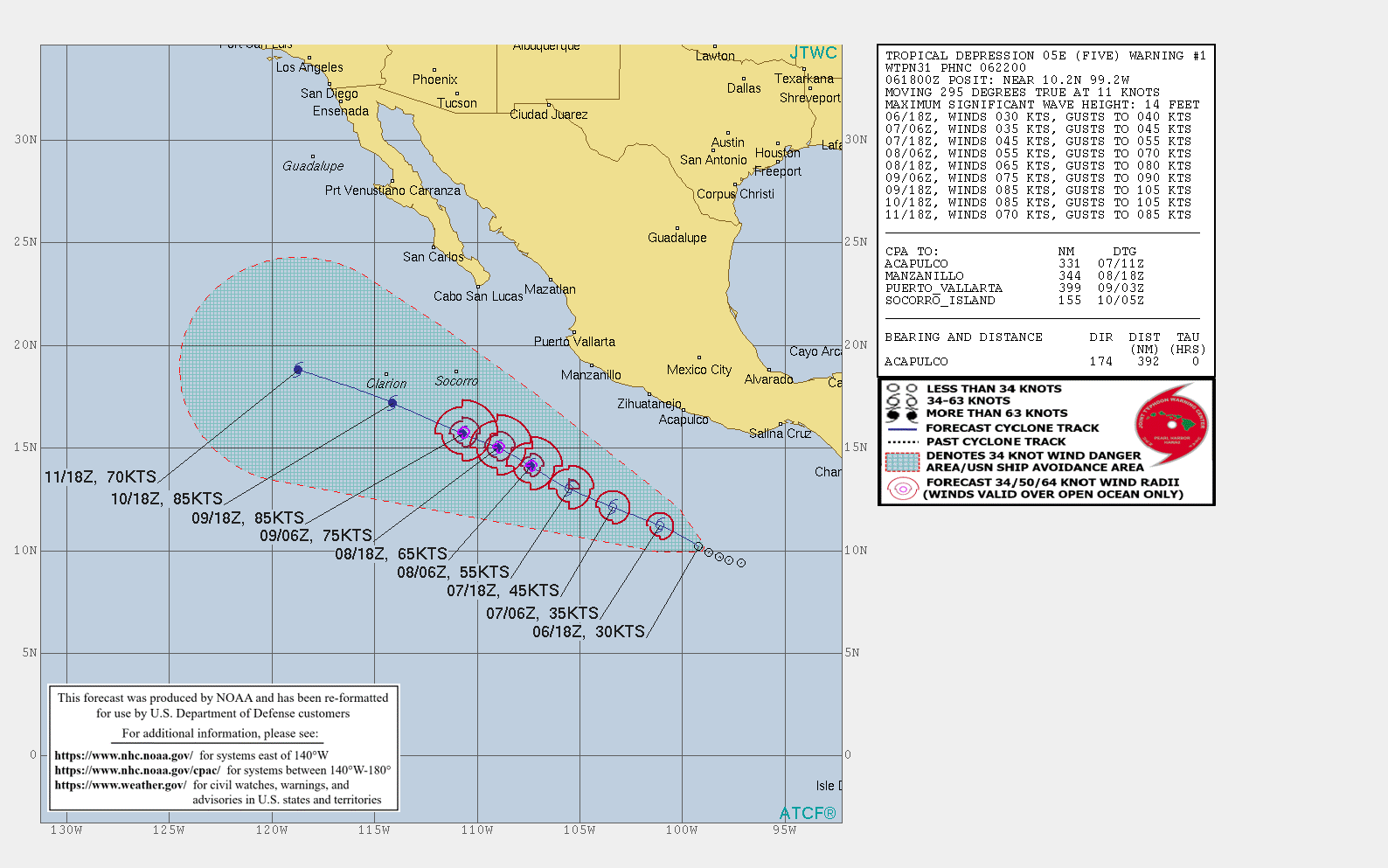
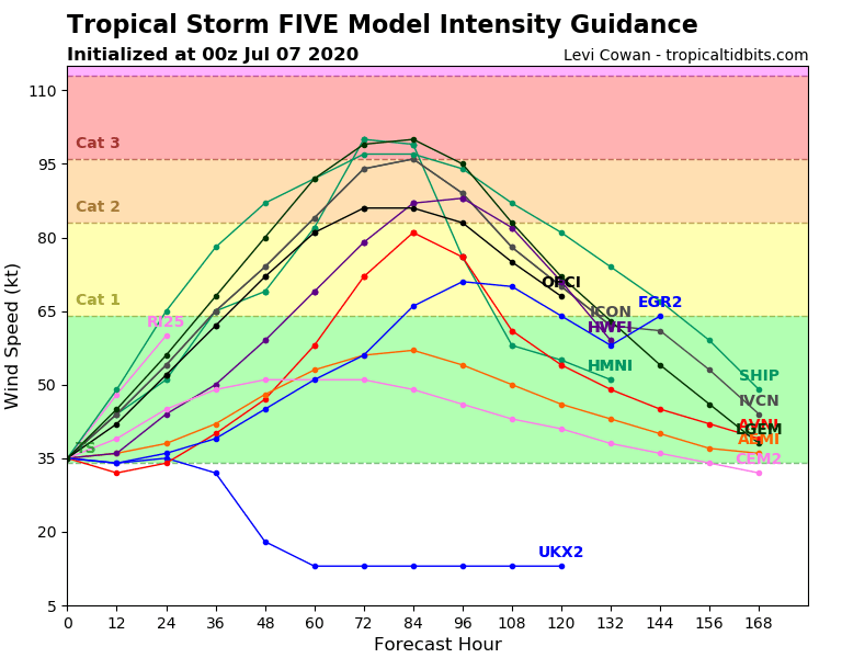
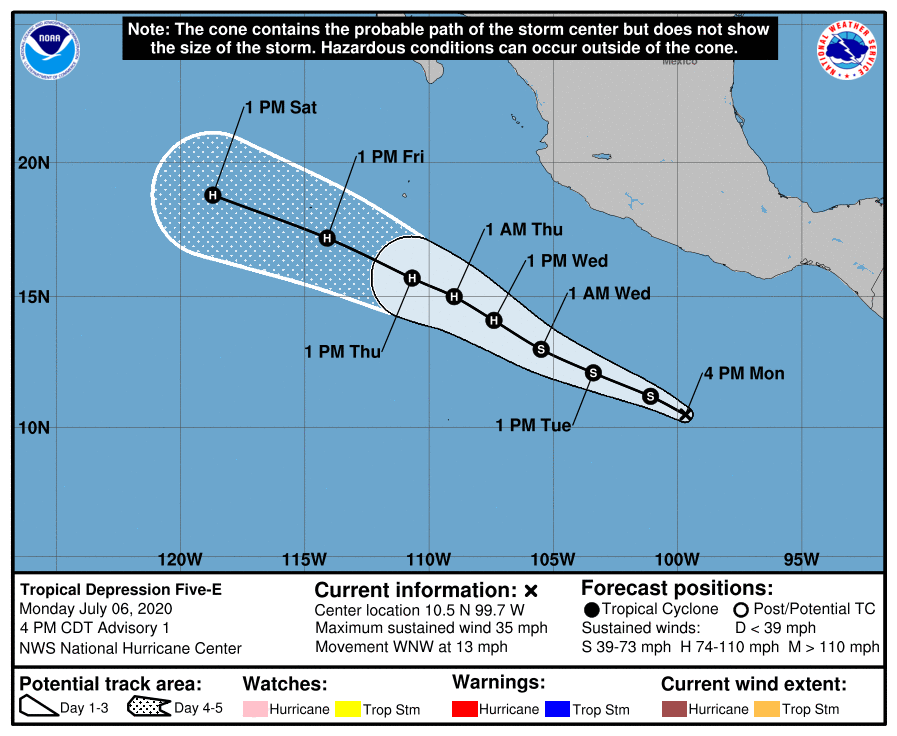
NHC06/21Z報升格其為TD05E,初報上望85KT
208
WTPZ45 KNHC 062038
TCDEP5

Tropical Depression Five-E Discussion Number   1
NWS National Hurricane Center Miami FL       EP052020
400 PM CDT Mon Jul 06 2020

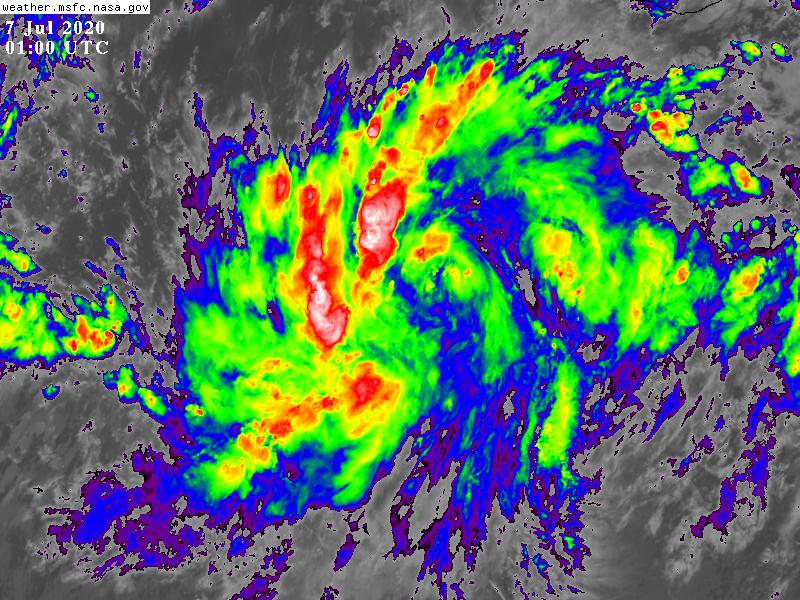
Satellite imagery shows that deep convection associated with the
low pressure area south of Mexico has become significantly better
organized since this morning.  ASCAT data from earlier this
afternoon suggested that the circulation was still somewhat
elongated, but since that time low cloud motions indicate that
the circulation has become better defined.  The scatterometer data
also revealed believable wind vectors of at least 30 kt, with
higher rain-inflated vectors within the deep convection. Based on
these data, advisories are being initiated on a 30-kt tropical
depression at this time.

The depression is located within a favorable environment consisting
of low vertical wind shear, warm sea-surface temperatures, and a
moist atmosphere.  As a result, steady strengthening is anticipated
over the next several days, and the NHC forecast calls for the
cyclone to become a hurricane in about 48 hours. The NHC intensity
forecast is in best agreement with the intensity consensus aids IVCN
and HCCA, but is not quite as bullish as the SHIPS guidance.  Given
the anticipated low wind shear conditions over the next few days, a
period of rapid strengthening is possible, and this intensity
forecast could be somewhat conservative. The cyclone is expected to
move over cooler waters in about 96 hours, which should cause
weakening by the end of the period.  

Since the depression is still in its formative stage, the initial
motion is a somewhat uncertain 295/11 kt. The depression is being
steered west-northwestward to the south of a large mid-level ridge
located over the south-central United States. A general
west-northwestward heading about around the same forward speed is
expected over the next several days.  The dynamical model guidance
is in fairly good agreement on this scenario and the NHC track
forecast lies near the various consensus aids.

FORECAST POSITIONS AND MAX WINDS

INIT  06/2100Z 10.5N  99.7W   30 KT  35 MPH
12H  07/0600Z 11.2N 101.1W   35 KT  40 MPH
24H  07/1800Z 12.1N 103.4W   45 KT  50 MPH
36H  08/0600Z 13.0N 105.5W   55 KT  65 MPH
48H  08/1800Z 14.1N 107.4W   65 KT  75 MPH
60H  09/0600Z 15.0N 109.0W   75 KT  85 MPH
72H  09/1800Z 15.7N 110.7W   85 KT 100 MPH
96H  10/1800Z 17.2N 114.1W   85 KT 100 MPH
120H  11/1800Z 18.8N 118.7W   70 KT  80 MPH

$$
Forecaster Brown
204051_5day_cone_with_line_and_wind.png ep0520.gif
05E_intensity_latest.png GOES01002020189tN85Ud.jpg
回復

使用道具 舉報

簽到天數: 1650 天

[LV.Master]伴壇終老

老農民版夜神月|2020-7-7 11:51 | 顯示全部樓層
本帖最後由 老農民版夜神月 於 2020-7-7 12:05 編輯

03Z命名Cristina
WTPZ45 KNHC 070232
TCDEP5

Tropical Storm Cristina Discussion Number   2
NWS National Hurricane Center Miami FL       EP052020
1000 PM CDT Mon Jul 06 2020

Satellite imagery indicates that convection has increased and
become better organized since the previous advisory, although
convection has waned somewhat during the past couple of hours due
to entrainment of dry mid-level air. A 2213Z SSMI overpass showed a
small but well-defined mid-level eye feature in the 85 GHz data and
the latest TAFB satellite classification was T2.0/30 kt. Based on
the improved banding features and the mid-level eye, the intensity
has been increased to a conservative 35 kt.

The initial motion estimate is 300/13 kt, based on a blend of TAFB
and microwave satellite fixes. Cristina is expected to be steered
west-northwestward throughout the forecast period along the southern
periphery of a large deep-layer ridge that extends westward from the
south-central and southwestern United States. The latest NHC model
guidance has become more tightly packed around the previous forecast
track, so only minor tweaks were made in the form of a slightly
faster forward speed. The NHC track forecast lies close to the
simple consensus models, which are a little south of the
corrected-consensus model HCCA.

Cristina is expected to remain in quite favorable environmental and
oceanic conditions for the next 72 h or so. The small inner-core
eye-like feature and the expected low vertical shear and impressive
upper-level outflow conditions suggest that rapid intensification
(RI) could occur at some point occur during that time. However,
recent entrainment of dry mid-level air into the eastern
semicircle has eroded convection in that part of the circulation,
and the dry air may have even penetrated into and disrupted the
inner core itself. Given the aforementioned uncertainty in the
structure of the cyclone, RI is not being explicitly forecast at
this time, although the official intensity forecast is higher than
the previous advisory through 96 h. By 120 h, significant weakening
should be well underway when Cristina will be moving over 24-deg-C
sea-surface temperatures. The NHC official intensity forecast
follows the trend of the previous forecast, and there is a distinct
possibility that Cristina could undergo RI and also become a major
hurricane if the inner-core region has not been disrupted.

FORECAST POSITIONS AND MAX WINDS

INIT  07/0300Z 11.2N 101.3W   35 KT  40 MPH
12H  07/1200Z 11.9N 103.0W   45 KT  50 MPH
24H  08/0000Z 12.9N 105.3W   55 KT  65 MPH
36H  08/1200Z 13.9N 107.3W   70 KT  80 MPH
48H  09/0000Z 14.8N 109.0W   80 KT  90 MPH
60H  09/1200Z 15.7N 110.7W   90 KT 105 MPH
72H  10/0000Z 16.5N 112.3W   95 KT 110 MPH
96H  11/0000Z 18.1N 116.1W   85 KT 100 MPH
120H  12/0000Z 19.9N 121.6W   70 KT  80 MPH

$$
Forecaster Stewart
未命名01.png 未命名.png
goes16_truecolor_05E_202007070125.gif
回復

使用道具 舉報

簽到天數: 1650 天

[LV.Master]伴壇終老

老農民版夜神月|2020-7-13 15:36 | 顯示全部樓層
本帖最後由 老農民版夜神月 於 2020-7-13 16:00 編輯

發展未如原先預測般順遂,巔峰僅達TS上限60KT,無緣成為今年風季第一個颶風
NHC13/03Z判定已減弱為殘餘低氣壓
WTPZ45 KNHC 130239
TCDEP5

Post-Tropical Cyclone Cristina Discussion Number  26
NWS National Hurricane Center Miami FL       EP052020
800 PM PDT Sun Jul 12 2020

Cristina has lacked deep convection for more than 12 hours and is
now a swirl of low- to mid-level clouds. The system has therefore
become a remnant low and this is the last NHC advisory. The
estimated intensity is 30 kt, assuming some spin down has occurred
since the last advisory.

Cristina is moving westward near 10 kt, and low-level easterly flow
should steer the remnant low on this general heading for the next
few days. The cyclone is moving over sea surface temperatures of
about 23 deg C that will prevent the redevelopment of organized
convection. Cristina should continue to gradually spin down during
the next 2-3 days until it opens into a trough and dissipates.

FORECAST POSITIONS AND MAX WINDS

INIT  13/0300Z 20.7N 126.5W   30 KT  35 MPH...POST-TROP/REMNT LOW
12H  13/1200Z 21.0N 128.3W   30 KT  35 MPH...POST-TROP/REMNT LOW
24H  14/0000Z 21.5N 130.8W   25 KT  30 MPH...POST-TROP/REMNT LOW
36H  14/1200Z 22.0N 133.6W   20 KT  25 MPH...POST-TROP/REMNT LOW
48H  15/0000Z 22.6N 136.4W   20 KT  25 MPH...POST-TROP/REMNT LOW
60H  15/1200Z 22.9N 139.1W   20 KT  25 MPH...POST-TROP/REMNT LOW
72H  16/0000Z...DISSIPATED

$$
Forecaster Zelinsky

1280px-Cristina_2020_track.png
024126_5day_cone_no_line_and_wind.png 064007bqk00i7c74ep83gc.jpeg goes17_ir_05E_202007130505.gif
回復

使用道具 舉報

快速回覆
您需要登錄後才可以回帖 登錄 | 立即加入

本版積分規則

本平台僅供學術討論之用,預報應以氣象局為準

威普網站虛擬主機贊助公司

臺灣第一個天氣類型社群平台 即時天氣資訊、精準颱風動態

線上客服
FB傳送訊息
廣告行銷
精準行銷 物超所值
官方粉專
發佈 快速回復 返回頂部 返回列表