開啟輔助訪問
 找回密碼
 立即加入

19L.Sally 巔峰登陸阿拉巴馬州 轉化溫氣

簽到天數: 2098 天

[LV.Master]伴壇終老

周子堯@FB|2020-9-12 06:51 | 顯示全部樓層
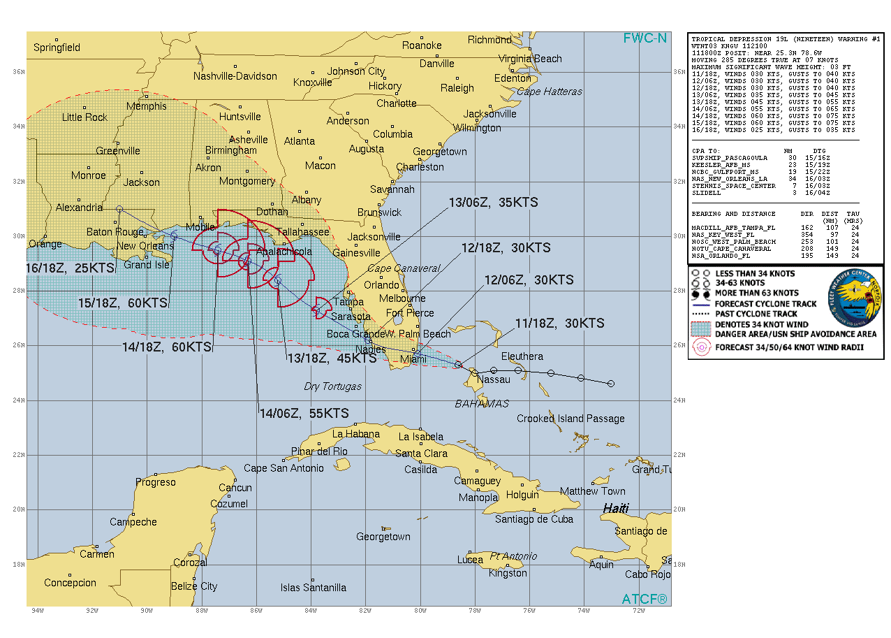
升格19L,首報上望60kts,或將進入墨西哥灣,再發展
148
WTNT44 KNHC 112059
TCDAT4

Tropical Depression Nineteen Discussion Number   1
NWS National Hurricane Center Miami FL       AL192020
500 PM EDT Fri Sep 11 2020

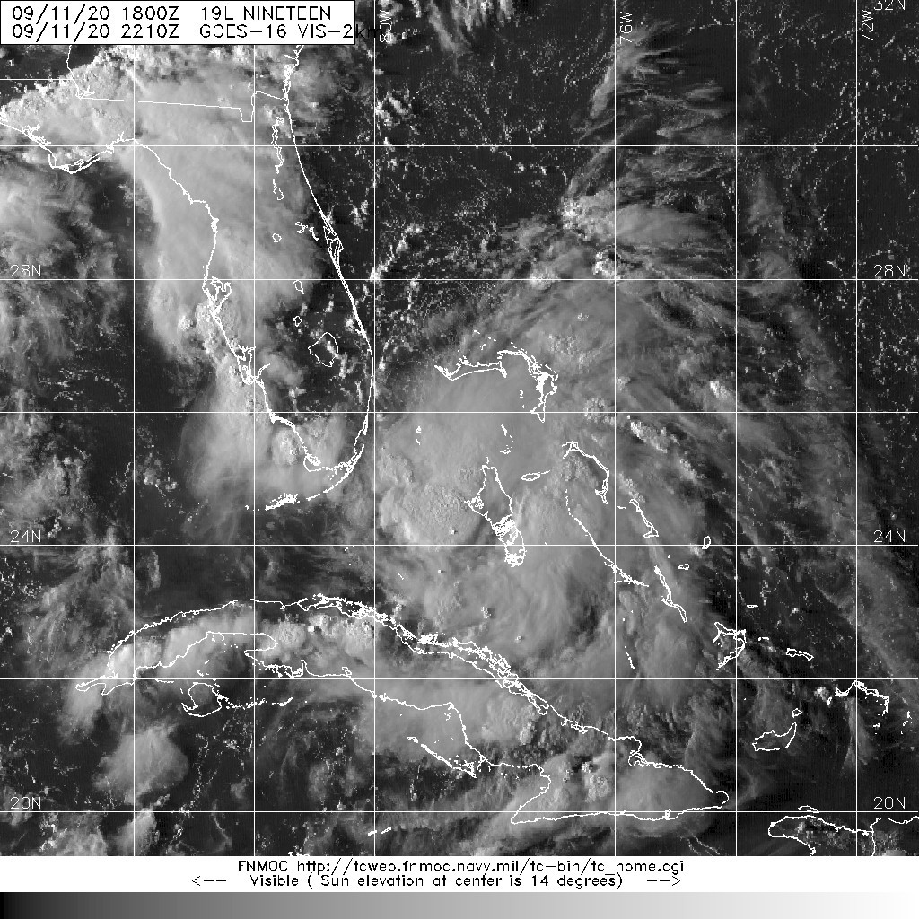
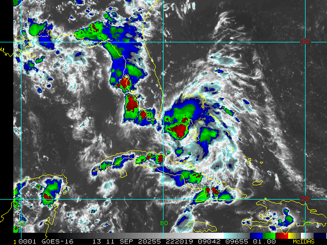
GOES-16 1-minute satellite data show that the system near the
Bahamas that we have been monitoring for the past couple of days
has quickly organized into a tropical depression.  Very deep
convection has formed near the center, and the 1-min data now shows
enough north and northwest flow to indicate that a well-defined
center is present.  The initial wind speed is 30 kt in agreement
with recent ship data.  

It is uncertain whether the large burst of convection over the
center will continue and cause the depression to become a tropical
storm before reaching Florida.  However, since it is only a 5 kt
increase from the current intensity, it is possible that tropical
storm conditions could still occur along the southeast Florida coast
late tonight, and a tropical storm watch has been issued.  
Otherwise, after the system reaches the eastern Gulf of Mexico,
steady intensification is expected through the weekend due to
expected light wind shear and very warm water. Some increase in
shear could occur over the northern Gulf of Mexico but that is
uncertain at this time.  The first forecast will stay conservative
and only show a peak intensity of 60 kt in 3 to 4 days, but do not
be surprised if that is revised upward on later forecasts once
other models better initialize the depression.

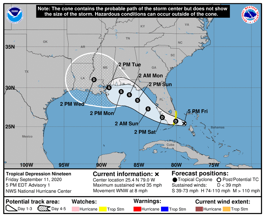
An uncertain estimate of the initial motion is 285/7. Strong
ridging over the southeastern United States is expected to steer the
cyclone to the west-northwest then northwest as a mid-latitude
trough erodes the western side of the ridge over the weekend.  The
forecast gets tricky after that because the bulk of the guidance
suggests the trough isn't deep enough to recurve the system, and
instead it gets left behind, moving slowly westward early next week
due to weak ridging over the southern Plains.  The NHC forecast is
near the corrected-consensus guidance.  The uncertainty in the
track forecast is much larger than normal after 48 hours, as small
changes in the forecast steering flow could result in this system
moving over the northern Gulf Coast faster and to the northeast of
what is shown here. As a result, the risk of seeing direct impacts
from this system extends well outside the cone of uncertainty, even
more so than usual in this case.

KEY MESSAGES:

1. Heavy rainfall is expected to produce isolated flash flooding
over portions of central and southern Florida and prolong existing
minor river flooding in the Tampa Bay area.

2. Tropical storm conditions are possible tonight along the
southeast Florida coast where a Tropical Storm Watch is in effect.  

3. The system is forecast to strengthen to near hurricane intensity
by early next week as it moves across the northeastern Gulf of
Mexico. Dangerous impacts from storm surge, wind, and heavy rainfall
will be possible along the Gulf Coast from the Florida Panhandle to
southeastern Louisiana this weekend and early next week. Residents
in these areas should monitor the progress of this system and
updates to the forecast, as Storm Surge, Tropical Storm or Hurricane
watches could be issued later tonight and Saturday.

FORECAST POSITIONS AND MAX WINDS

INIT  11/2100Z 25.4N  79.0W   30 KT  35 MPH
12H  12/0600Z 25.7N  80.1W   30 KT  35 MPH
24H  12/1800Z 26.2N  81.9W   30 KT  35 MPH
36H  13/0600Z 27.3N  83.8W   35 KT  40 MPH
48H  13/1800Z 28.4N  85.2W   45 KT  50 MPH
60H  14/0600Z 29.1N  86.3W   55 KT  65 MPH
72H  14/1800Z 29.5N  87.4W   60 KT  70 MPH
96H  15/1800Z 30.0N  89.0W   60 KT  70 MPH
120H  16/1800Z 31.0N  91.0W   25 KT  30 MPH...INLAND

$$
Forecaster Blake
205735_5day_cone_no_line_and_wind.png
al192020.20091112.gif
20200911.2210.goes-16.vis.2km.19L.NINETEEN.25kts.1011mb.25.3N.78.6W.pc.jpg
2020al19_4kmirimg_202009112220.gif
回復

使用道具 舉報

簽到天數: 1650 天

[LV.Master]伴壇終老

老農民版夜神月|2020-9-12 02:20 | 顯示全部樓層
FWC-N發布TCFA
WTNT21 KNGU 111800
SUBJ/TROPICAL CYCLONE FORMATION ALERT//
RMKS/1.FORMATION OF A SIGNIFICANT
TROPICAL CYCLONE IS POSSIBLE WITHIN
100 NM EITHER SIDE OF A LINE FROM 25.0N 78.1W TO 26.7N 83.5W
WITHIN THE NEXT 12 TO 24 HOURS. AVAILABLE DATA DOES NOT JUSTIFY
ISSUANCE OF NUMBERED TROPICAL CYCLONE WARNINGS AT THIS TIME.
WINDS IN THE AREA ARE ESTIMATED TO BE 25 KNOTS. METSAT
IMAGERY AT 111600Z INDICATES THAT A CIRCULATION CENTER IS LOCATED
NEAR 25.0N 78.0W. THE SYSTEM IS MOVING WEST-NORTHWESTWARD AT 08
KNOTS.
2.REMARKS: A LARGE AREA OF SHOWERS AND THUNDERSTORMS
ASSOCIATED WITH A DEVELOPING BROAD AREA OF LOW
PRESSURE NEAR ANDROS ISLAND, BAHAMAS CONTIUES TO BECOME BETTER
ORGANIZED. SURFACE OBSERVATIONS IN THE NORTHWESTERN AND CENTRAL
BAHAMAS INDICATE THAT PRESSURES HAVE FALLEN 4 MB DURING THE PAST
24 HOURS. IF THESE DEVELOPMENTAL TRENDS CONTINUE A TROPICAL
DEPRESSION COULD FORM JUST PRIOR TO REACHING THE SOUTH FLORIDA
COAST LATE TONIGHT OR WHILE IT MOVES GENERALLY WEST-NORTHWESTWARD
AND ENTERS THE EASTERN GULF OF MEXICO ON SATURDAY.
3.THIS ALERT WILL BE REISSUED, UPGRADED TO WARNING OR CANCELLED BY
121800Z.//
BT
#0001
NNNN

al962020.20200911175828.gif GOES18062020255wxWSES.jpg
96L_gefs_latest.png

評分

參與人數 1水氣能量 +15 收起 理由
king111807 + 15 TCFA

查看全部評分

回復

使用道具 舉報

簽到天數: 1650 天

[LV.Master]伴壇終老

老農民版夜神月|2020-9-12 01:53 | 顯示全部樓層
NHC展望提升至High,70%
1. Shower and thunderstorm activity located over the northwestern and
central Bahamas and the adjacent waters continues to shows signs of
organization.  In addition, surface observations indicate that
pressures have fallen over the area since yesterday and, along with
wind and satellite data, suggest that a broad area of low pressure
could be forming between the northwestern Bahamas and South Florida.
This system is forecast to move westward at about 10 mph, and it
could become a tropical depression while it is near South Florida
tonight.  But if not, the disturbance is expected to become a
tropical depression while it moves slowly west-northwestward over
the northeastern Gulf of Mexico this weekend and early next week.  
Regardless of development, this system is expected to produce
locally heavy rainfall over portions of the Bahamas, South Florida,
and the Florida Keys during the next couple of days, and interests
there, as well as along the northern and eastern Gulf coast, should
monitor its progress.
* Formation chance through 48 hours...high...70 percent.
* Formation chance through 5 days...high...80 percent.

two_atl_2d1.png two_atl_5d1.png
20200911.1710.goes-16.vis.2km.96L.INVEST.25kts.1011mb.25N.78W.pc.jpg


回復

使用道具 舉報

簽到天數: 1650 天

[LV.Master]伴壇終老

老農民版夜神月|2020-9-11 14:32 | 顯示全部樓層
NHC將96L重新定位至美國東南方近海,因此應該是1.
1. A large area of disorganized showers and thunderstorms extending
from near the Central and Northwest Bahamas eastward over the
western Atlantic for a few hundred miles is associated with a
surface trough of low pressure.  This system is forecast to
move westward, crossing the Bahamas and Florida on Friday and moving
into the eastern Gulf of Mexico over the weekend.  Upper-level
winds are expected to become conducive for development, and a
tropical depression could form while this system moves slowly
west-northwestward over the eastern Gulf of Mexico early next week.
Regardless of development, this system is expected to produce
locally heavy rainfall over portions of South Florida and the Keys
during the next couple of days.
* Formation chance through 48 hours...low...10 percent.
* Formation chance through 5 days...medium...50 percent.

sfcplot_96L_latest.png 20200911.0550.goes-16.ir.96L.INVEST.20kts.1013mb.25.3N.77.5W.100pc.jpg
two_atl_2d1 (2) (2).png
回復

使用道具 舉報

12
快速回覆
您需要登錄後才可以回帖 登錄 | 立即加入

本版積分規則

本平台僅供學術討論之用,預報應以氣象局為準

威普網站虛擬主機贊助公司

臺灣第一個天氣類型社群平台 即時天氣資訊、精準颱風動態

線上客服
FB傳送訊息
廣告行銷
精準行銷 物超所值
官方粉專
發佈 快速回復 返回頂部 返回列表