開啟輔助訪問
 找回密碼
 立即加入

25L.Gamma 巔峰登陸墨西哥

簽到天數: 1650 天

[LV.Master]伴壇終老

2020-10-1 20:58 | 顯示全部樓層
  熱帶風暴  
編號:25 L
名稱:Gamma
231453ywue9re579vzd7p9.jpg
  基本資料  
擾動編號日期:2020 10 01 20
命名日期  :2020 10 03 08
撤編日期  :2020 10 00 00
登陸地點  :墨西哥

  巔峰時期資料  
近中心最強風速 :60  kt
( TS)
海平面最低氣壓 :986 百帕

  擾動編號資料  

91L.INVEST.20kts-1008mb-15.4N-81.0W
20201001.1230.goes-16.vis.2km.91L.INVEST.20kts.1008mb.15.4N.81W.pc.jpg

  NHC:40%  
1. A tropical wave located over the west-central Caribbean Sea is
producing a large area of disorganized showers and thunderstorms.  
Conditions are expected to be conducive for development of this
system, and a tropical depression is likely to form over the
northwestern Caribbean Sea or the south-central Gulf of Mexico,
possibly before the system reaches the east coast of the Yucatan
Peninsula on Saturday.  Interests in Belize, the Yucatan Peninsula
of Mexico, and western Cuba should monitor the progress of this
disturbance.
* Formation chance through 48 hours...medium...40 percent.
* Formation chance through 5 days...high...70 percent.

two_atl_2d1 (2) (6).png two_atl_5d1 (2) (3).png
以上資料來自:NHC、颱風論壇整理製作

評分

參與人數 1水氣能量 +15 +1 收起 理由
s6815711 + 15 + 1 熱帶擾動首帖

查看全部評分

回復

使用道具 舉報

簽到天數: 1650 天

[LV.Master]伴壇終老

老農民版夜神月|2020-10-6 11:58 | 顯示全部樓層
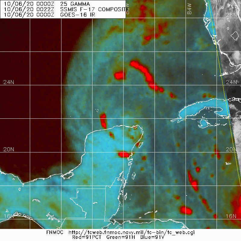
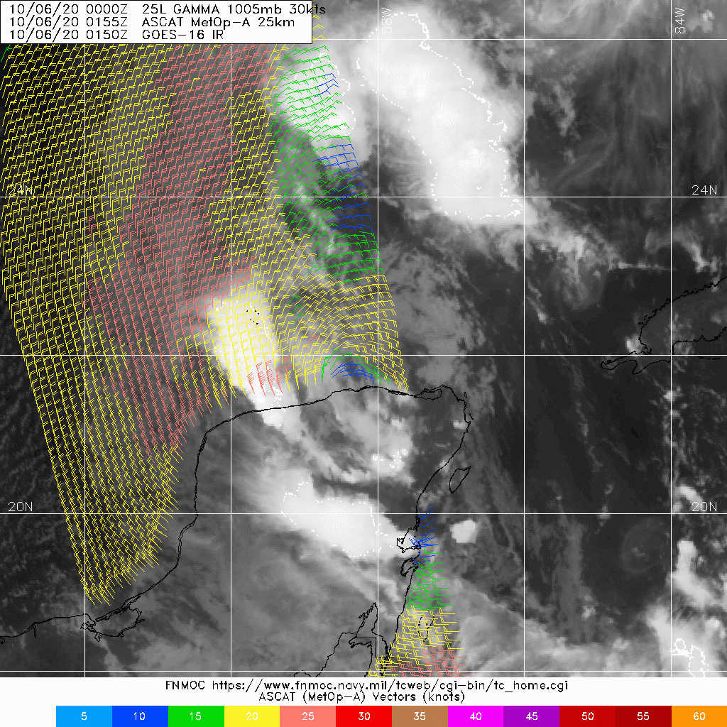
NHC判定03Z已退化為殘餘低氣壓
AL, 25, 2020100600,   , BEST,   0, 219N,  882W,  30, 1005, TD,
000
WTNT45 KNHC 060231
TCDAT5

Post-Tropical Cyclone Gamma Discussion Number  15
NWS National Hurricane Center Miami FL       AL252020
1000 PM CDT Mon Oct 05 2020

Gamma was entirely devoid of convection for most of the day. Shortly
before sunset, a few disorganized thunderstorms developed to the
southeast of the cyclone's center, however these appear to be forced
at least in part by a sea breeze boundary and are not exclusively
associated with Gamma. A few other small cells of convection have
developed to the west of Gamma's center during the past hour or so,
but not nearly enough to be considered sufficiently organized to
meet the requirement for a tropical cyclone. Gamma is therefore now
considered to be post-tropical and this will be the last NHC
advisory.

The cyclone could still produce some additional disorganized
convection and periods of heavy rain overnight as it moves inland
over the Yucatan peninsula, but this is not expected to result in
significant regeneration. Some of this rain could impact areas that
are preparing for the much more significant approach of Hurricane
Delta in a day or so. The cyclone is moving southwestward near
5 kt, and this should continue for another day or so until it
dissipates. The winds associated with Gamma's remnants should
gradually weaken through that time, though the system could still
produce a few areas of heavy rain over southeastern Mexico.

It is worth noting that several model trackers, and consequently
the consensus aids, depict that Gamma will move northward over the
Gulf of Mexico and strengthen significantly in a couple of days.
This is because the trackers lose track of Gamma when it dissipates
and start following nearby Hurricane Delta instead. In reality, no
models forecast that Gamma will remain a well-defined cyclone for
more than another day or two.


FORECAST POSITIONS AND MAX WINDS

INIT  06/0300Z 21.6N  88.4W   30 KT  35 MPH...POST-TROPICAL
12H  06/1200Z 21.1N  88.9W   30 KT  35 MPH...POST-TROP/INLAND
24H  07/0000Z 20.2N  89.6W   25 KT  30 MPH...POST-TROP/INLAND
36H  07/1200Z...DISSIPATED

$$
Forecaster Zelinsky
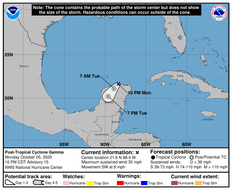
023244_5day_cone_no_line_and_wind.png 20201006.0022.f17.91pct91h91v.25L.GAMMA.30kts.1005mb.21.9N.88.2W.095pc.jpg
LATEST (32).jpg
回復

使用道具 舉報

簽到天數: 1650 天

[LV.Master]伴壇終老

老農民版夜神月|2020-10-6 01:00 | 顯示全部樓層
出海後中心已經裸露,大幅減弱,預估將在墨西哥近海迂迴後再次登陸
FORECAST POSITIONS AND MAX WINDS

INIT  05/1500Z 22.3N  87.6W   40 KT  45 MPH
12H  06/0000Z 22.1N  88.4W   40 KT  45 MPH
24H  06/1200Z 21.6N  89.2W   35 KT  40 MPH
36H  07/0000Z 20.9N  89.9W   30 KT  35 MPH...INLAND
48H  07/1200Z 20.2N  90.2W   25 KT  30 MPH...POST-TROP/INLAND
60H  08/0000Z 20.3N  89.8W   25 KT  30 MPH...POST-TROP/INLAND
72H  08/1200Z 21.0N  89.5W   20 KT  25 MPH...POST-TROP/INLAND
96H  09/1200Z...DISSIPATED

20201005.1620.goes-16.vis.2km.25L.GAMMA.40kts.1001mb.22.6N.87.5W.pc.jpg 151451_5day_cone_with_line_and_wind.png
GOES16302020279OkufoC.jpg goes16_ir_25L_202010051537.gif
回復

使用道具 舉報

簽到天數: 3279 天

[LV.Master]伴壇終老

t02436|2020-10-4 01:07 | 顯示全部樓層
已登陸墨西哥圖盧姆。
000
WTNT65 KNHC 031658
TCUAT5

Tropical Storm Gamma Tropical Cyclone Update
NWS National Hurricane Center Miami FL       AL252020
1200 PM CDT Sat Oct 03 2020

...GAMMA MAKES LANDFALL NEAR TULUM, MEXICO...

Surface observations and satellite images indicate that the center
of Tropical Storm Gamma made landfall in the northeast Yucatan
Peninsula near Tulum, Mexico, around 1145 AM CDT.
  The storm was
very close to hurricane strength at landfall, with maximum
sustained winds near 70 MPH (110 MPH) with higher gusts.

A weather station at Xel-Ha Park, along the Yucatan coast just
north of Tulum, reported a sustained wind of 55 mph (89 km/h) and a
gust to 68 mph (109 km/h) within the past hour.


SUMMARY OF 1200 PM CDT...1700 UTC...INFORMATION
---------------------------------------------------
LOCATION...20.2N 87.5W
ABOUT 0 MI...0 KM N OF TULUM MEXICO
MAXIMUM SUSTAINED WINDS...70 MPH...110 KM/H
PRESENT MOVEMENT...NW OR 315 DEGREES AT 9 MPH...15 KM/H
MINIMUM CENTRAL PRESSURE...980 MB...28.94 INCHES

$$
Forecaster Pasch

4da955e0-3160-48f2-85ee-6dfcdc3e70ce.gif

GOES16512020277SUgA7t.jpg
回復

使用道具 舉報

簽到天數: 3279 天

[LV.Master]伴壇終老

t02436|2020-10-3 23:14 | 顯示全部樓層
即將以60節巔峰登陸墨西哥
008
WTNT45 KNHC 031457
TCDAT5

Tropical Storm Gamma Discussion Number   5
NWS National Hurricane Center Miami FL       AL252020
1000 AM CDT Sat Oct 03 2020

Observations from both the Air Force and NOAA Hurricane Hunters
indicate that Gamma has continued to strengthen this morning.  The
cloud pattern has continued to become better organized, with an eye
trying to become evident on high-resolution satellite images from
the GOES-16 mesoscale sectors.  Flight-level and SFMR-observed
surface winds from the aircraft support an intensity of 60 kt, and
the storm could strengthen a little more as long as the center
remains over water.  Since Gamma will be near or at hurricane
intensity when it makes landfall later today, the government of
Mexico has issued a Hurricane Warning for a portion of the
northeastern Yucatan Peninsula.  Gamma should weaken some while it
moves over land tonight.  Some re-intensification is likely after
the center moves into the southern Gulf of Mexico.  However, the
numerical guidance does not show much strengthening during the next
few days, possibly due to the influence of drier air and/or the
interaction with another area of low pressure to the east of Gamma.
The official intensity forecast is near or above the model
consensus.

Gamma continues northwestward at near 8 kt.  The cyclone is
expected to turn north-northwestward and move through a break in
the subtropical ridge through 36 hours or so.  Thereafter, a trough
to the north moves eastward, bypassing Gamma, and later in the
forecast period a ridge builds weakly over the Gulf of Mexico.  
This should cause the cyclone to turn toward the west and
southwest.  The official track forecast is close to the multi-model
consensus, TVCN.

Although Gamma has strengthened, its biggest threat continues to be
torrential rains, flooding, and mudslides especially near and over
mountainous terrain.


KEY MESSAGES:

1. Gamma is expected to produce heavy rainfall for several
days over portions of southeastern Mexico, the Yucatan
Peninsula, Central America, and far western Cuba.  This
rainfall could result in life-threatening flash flooding
and mudslides, particularly in the mountainous regions of
southeastern Mexico and Central America.

2. Gamma is very near hurricane strength and will be near or at
hurricane intensity when the center moves inland over the Yucatan
Peninsula later today.  A Hurricane Warning is now in effect
for portions of the east coast of the Yucatan Peninsula, where
tropical storm conditions are already occurring.  Tropical storm
conditions are expected along the north coast of the Yucatan
Peninsula within the Tropical Storm Warning area later today
and on Sunday.


FORECAST POSITIONS AND MAX WINDS

INIT  03/1500Z 20.0N  87.3W   60 KT  70 MPH
12H  04/0000Z 20.8N  87.8W   55 KT  65 MPH...INLAND
24H  04/1200Z 21.8N  88.1W   40 KT  45 MPH...OVER WATER
36H  05/0000Z 22.2N  88.3W   40 KT  45 MPH
48H  05/1200Z 22.3N  88.8W   45 KT  50 MPH
60H  06/0000Z 22.1N  89.7W   50 KT  60 MPH
72H  06/1200Z 22.0N  91.0W   50 KT  60 MPH
96H  07/1200Z 21.0N  92.5W   45 KT  50 MPH
120H  08/1200Z 20.0N  93.5W   40 KT  45 MPH

$$
Forecaster Pasch

150003_5day_cone_with_line.png

GOES150120202777SJNNj.jpg

goes16_truecolor_25L_202010031357.gif
回復

使用道具 舉報

簽到天數: 1650 天

[LV.Master]伴壇終老

老農民版夜神月|2020-10-3 21:44 來自手機 | 顯示全部樓層
本帖最後由 老農民版夜神月 於 2020-10-3 21:46 編輯

發展超乎預期,中心即將觸陸,NHC12Z定強已提升至55節,中心氣壓986百帕
AL, 25, 2020100312,   , BEST,   0, 197N,  872W,  55,  986, TS,

114541_5day_cone_no_line_and_wind.png 20201003.1310.goes-16.vis.2km.25L.GAMMA.55kts.986mb.19.7N.87.2W.pc.jpg
20201003.0716.gw1.89pct89h89v.25L.GAMMA.40kts.996mb.19.2N.86.6W.82pc.jpg goes16_ir_25L_202010031222.gif
回復

使用道具 舉報

簽到天數: 1650 天

[LV.Master]伴壇終老

老農民版夜神月|2020-10-3 08:17 | 顯示全部樓層
NHC03/00Z升格TS,命名Gamma
000
WTNT35 KNHC 022357
TCPAT5

BULLETIN
Tropical Storm Gamma Intermediate Advisory Number 2A
NWS National Hurricane Center Miami FL       AL252020
700 PM CDT Fri Oct 02 2020

...DEPRESSION BECOMES TROPICAL STORM GAMMA OVER THE NORTHWESTERN
CARIBBEAN SEA...


SUMMARY OF 700 PM CDT...0000 UTC...INFORMATION
----------------------------------------------
LOCATION...18.8N 85.8W
ABOUT 135 MI...220 KM SSE OF COZUMEL MEXICO
MAXIMUM SUSTAINED WINDS...40 MPH...65 KM/H
PRESENT MOVEMENT...NW OR 315 DEGREES AT 9 MPH...15 KM/H
MINIMUM CENTRAL PRESSURE...1000 MB...29.53 INCHES

235842_5day_cone_with_line_and_wind.png 20201002.2340.goes-16.ir.25L.TWENTY-FIV.30kts.1005mb.18.5N.85W.100pc.jpg
20201002.1905.gw1.89pct89h89v.25L.TWENTY-FIV.30kts.1005mb.18.5N.85W.94pc.jpg GOES23502020276DHDC78.jpg
回復

使用道具 舉報

簽到天數: 76 天

[LV.6]常住居民II

Heigo|2020-10-2 23:00 | 顯示全部樓層
本帖最後由 Heigo 於 2020-10-2 23:03 編輯

NHC升格25L
ZCZC MIATCPAT5 ALL
TTAA00 KNHC DDHHMM

BULLETINTropical Depression Twenty-Five Advisory Number   1
NWS National Hurricane Center Miami FL       AL252020
1100 AM EDT Fri Oct 02 2020

...TROPICAL DEPRESSION FORMS OVER THE NORTHWEST CARIBBEAN...
...WARNINGS AND WATCHES ISSUED FOR A PORTION OF THE YUCATAN
PENINSULA...


SUMMARY OF 1100 AM EDT...1500 UTC...INFORMATION
-----------------------------------------------
LOCATION...18.1N 84.7W
ABOUT 220 MI...355 KM SE OF COZUMEL MEXICO
MAXIMUM SUSTAINED WINDS...35 MPH...55 KM/H
PRESENT MOVEMENT...NW OR 315 DEGREES AT 9 MPH...15 KM/H
MINIMUM CENTRAL PRESSURE...1005 MB...29.68 INCHES


WATCHES AND WARNINGS
--------------------
CHANGES WITH THIS ADVISORY:

The government of Mexico has issued a Tropical Storm Warning for
the Yucatan Peninsula of Mexico from Punta Herrero to Cabo Catoche,
and a Tropical Storm Watch south of Punta Herrero to Puerto Costa
Maya and west of Cabo Catoche to Dzilam.

SUMMARY OF WATCHES AND WARNINGS IN EFFECT:

A Tropical Storm Warning is in effect for...
* Punta Herrero to Cabo Catoche

A Tropical Storm Watch is in effect for...
* South of Punta Herrero to Puerto Costa Maya
* West of Cabo Catoche to Dzilam

A Tropical Storm Warning means that tropical storm conditions are
expected somewhere within the warning area within 36 hours.

A Tropical Storm Watch means that tropical storm conditions are
possible within the watch area, generally within 48 hours.

For storm information specific to your area, please monitor
products issued by your national meteorological service.


DISCUSSION AND OUTLOOK
----------------------
At 1100 AM EDT (1500 UTC), the center of Tropical Depression
Twenty-Five was located near latitude 18.1 North, longitude 84.7
West.  The depression is moving toward the northwest near 9 mph (15
km/h), and a gradual turn toward the north-northwest with a
decrease in forward speed is expected over the next couple of
days.  On the forecast track, the center of the tropical cyclone
should be near the northeastern Yucatan Peninsula on Saturday.

Maximum sustained winds are near 35 mph (55 km/h) with higher gusts.
Some strengthening is forecast, and the depression is expected to
become a tropical storm by Saturday morning.

The estimated minimum central pressure is 1005 mb (29.68 inches).


HAZARDS AFFECTING LAND
----------------------
Key messages for the depression can be found in the Tropical Cyclone
Discussion under AWIPS header MIATCDAT5 and WMO header WTNT45 KNHC.

RAINFALL:  The depression is expected to produce rainfall of 4 to 8
inches with isolated maximum amounts of 12 inches in portions of the
Yucatan Peninsula and far western Cuba.  A separate area of
significant rain is expected to develop well away from the center in
the Mexican states of Campeche, Tabasco, and northern Chiapas, with
rainfall of 8 to 12 inches and isolated maximum amounts of 20
inches.  This rainfall may produce life-threatening flash floods and
mudslides.

Rainfall of 1 to 3 inches with maximum amounts of 5 inches is
expected in the Bay Islands of Honduras.

WIND:  Tropical storm conditions are expected within the Tropical
Storm Warning area by early Saturday, and are possible within the
Tropical Storm Watch area on Saturday and Sunday.


NEXT ADVISORY
-------------
Next intermediate advisory at 200 PM EDT.
Next complete advisory at 500 PM EDT.

$$
Forecaster Pasch

NNNN

回復

使用道具 舉報

12下一頁
快速回覆
您需要登錄後才可以回帖 登錄 | 立即加入

本版積分規則

本平台僅供學術討論之用,預報應以氣象局為準

威普網站虛擬主機贊助公司

臺灣第一個天氣類型社群平台 即時天氣資訊、精準颱風動態

線上客服
FB傳送訊息
廣告行銷
精準行銷 物超所值
官方粉專
發佈 快速回復 返回頂部 返回列表