開啟輔助訪問
 找回密碼
 立即加入

19E.Norbert 沿墨西哥西岸北行 曾二度成為TS

簽到天數: 1650 天

[LV.Master]伴壇終老

2020-10-4 08:19 | 顯示全部樓層
本帖最後由 老農民版夜神月 於 2020-10-16 02:07 編輯

  熱帶風暴  
編號:19 E
名稱:Norbert

150832nh6lezkb8egbkg8w.jpg
  基本資料  
擾動編號日期:2020 10 04 08
命名日期  :2020 10 06 14
撤編日期  :2020 10 00 00
登陸地點  :

  巔峰時期資料  
近中心最強風速 :40  kt
( TS )
海平面最低氣壓 :1002 百帕


  擾動編號資料    

以上資料來自:NHC、颱風論壇整理製作

20201003.2350.goes-17.ir.95E.INVEST.30kts.1008mb.9.5N.102.2W.100pc.jpg
two_pac_5d1 (2).png
two_pac_2d1 (2).png

評分

參與人數 1水氣能量 +15 +1 收起 理由
king111807 + 15 + 1 熱帶擾動首帖

查看全部評分

回復

使用道具 舉報

簽到天數: 1650 天

[LV.Master]伴壇終老

老農民版夜神月|2020-10-15 16:26 | 顯示全部樓層
本帖最後由 老農民版夜神月 於 2020-10-16 02:06 編輯

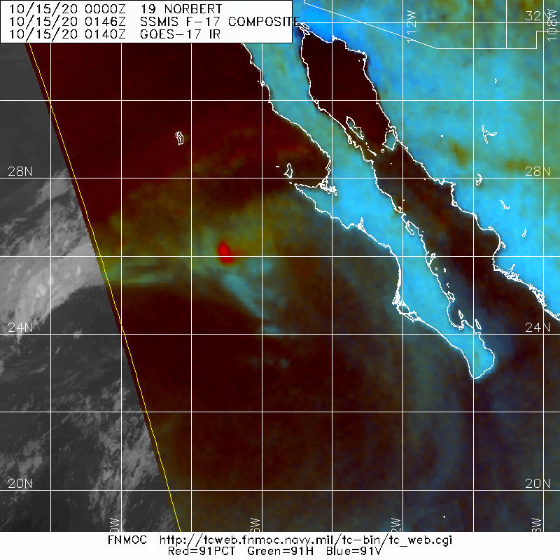
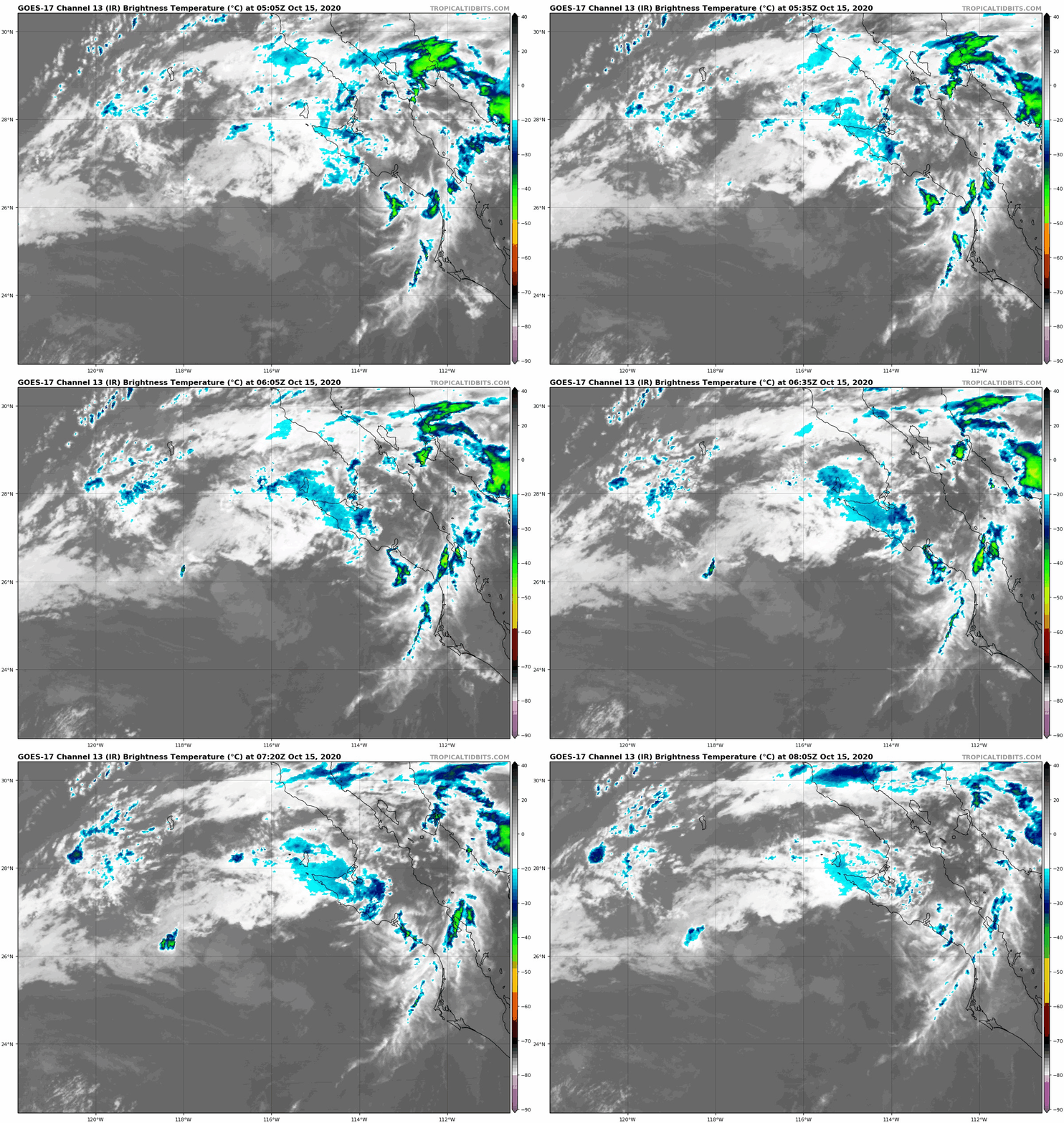
NHC認定於06Z退化為殘餘低氣壓
EP, 19, 2020101500,   , BEST,   0, 254N, 1155W,  25, 1008, TD,   0,    ,    0,    0,    0,    0, 1011,   90,  25,  35,   0,   E,   0,    ,   0,   0,    NORBERT, M,  0,    ,    0,    0,    0,    0, genesis-num, 036,
EP, 19, 2020101506,   , BEST,   0, 260N, 1159W,  25, 1010, LO,  34, NEQ,    0,    0,    0,    0, 1012,   90,  25,   0,   0,   E,   0,    ,   0,   0,    NORBERT, S,  0,    ,    0,    0,    0,    0, genesis-num, 036,
WTPZ24 KNHC 150830
TCMEP4

POST-TROPICAL CYCLONE NORBERT FORECAST/ADVISORY NUMBER  26
NWS NATIONAL HURRICANE CENTER MIAMI FL       EP192020
0900 UTC THU OCT 15 2020

THERE ARE NO COASTAL WATCHES OR WARNINGS IN EFFECT.

POST-TROPICAL CYCLONE CENTER LOCATED NEAR 26.2N 116.1W AT 15/0900Z
POSITION ACCURATE WITHIN  45 NM

PRESENT MOVEMENT TOWARD THE NORTH-NORTHWEST OR 335 DEGREES AT   6 KT

ESTIMATED MINIMUM CENTRAL PRESSURE 1010 MB
MAX SUSTAINED WINDS  25 KT WITH GUSTS TO  35 KT.
WINDS AND SEAS VARY GREATLY IN EACH QUADRANT.  RADII IN NAUTICAL
MILES ARE THE LARGEST RADII EXPECTED ANYWHERE IN THAT QUADRANT.

REPEAT...CENTER LOCATED NEAR 26.2N 116.1W AT 15/0900Z
AT 15/0600Z CENTER WAS LOCATED NEAR 26.0N 115.9W

FORECAST VALID 15/1800Z 27.1N 116.3W...POST-TROP/REMNT LOW
MAX WIND  20 KT...GUSTS  30 KT.

FORECAST VALID 16/0600Z...DISSIPATED

REQUEST FOR 3 HOURLY SHIP REPORTS WITHIN 300 MILES OF 26.2N 116.1W

THIS IS THE LAST FORECAST/ADVISORY ISSUED BY THE NATIONAL HURRICANE
CENTER ON NORBERT. FOR ADDITIONAL INFORMATION ON THE REMNANT LOW
PLEASE SEE HIGH SEAS FORECASTS ISSUED BY THE NATIONAL WEATHER
SERVICE...UNDER AWIPS HEADER NFDHSFEPI AND WMO HEADER FZPN02 KWBC.

$$
FORECASTER BROWN
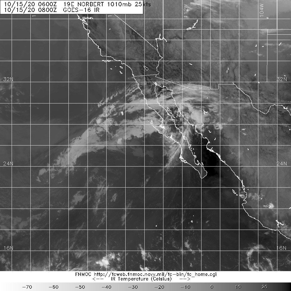
20201015.0800.goes-16.ir.19E.NORBERT.25kts.1010mb.26N.115.9W.100pc.jpg 20201015.0146.f17.91pct91h91v.19E.NORBERT.25kts.1008mb.25.4N.115.5W.080pc.jpg
goes17_ir_19E_202010150505.gif
回復

使用道具 舉報

簽到天數: 1650 天

[LV.Master]伴壇終老

老農民版夜神月|2020-10-14 15:36 | 顯示全部樓層
NHC認定Norbert重登TS,預測將維持TS強度12H後逐漸減弱
EP, 19, 2020101400,   , BEST,   0, 205N, 1123W,  35, 1005, TS,
882
WTPZ44 KNHC 140236
TCDEP4

Tropical Storm Norbert Discussion Number  21
NWS National Hurricane Center Miami FL       EP192020
900 PM MDT Tue Oct 13 2020

Norbert has increased in organization this evening, with a pair of
microwave passes as well as infrared satellite imagery showing a
tightly curved band of convection wrapping about halfway around the
low-level center. In addition, a well-defined outflow pattern is
surrounding the cyclone in the current low-shear environment. Based
on these developmental trends, the initial intensity has been
increased to 35 kt, which is in agreement with the latest Dvorak
intensity estimate from TAFB.

There is only about a 12-18 h opportunity for Norbert to maintain
its current strength or perhaps intensify a little more before it
reaches a hostile environment just to its north. By 24 h, the
cyclone is forecast to encounter strong southwesterly shear and a
dry and stable atmospheric environment, while moving over cooler
waters. Therefore, the cyclone should start weakening by 24 h and
should degenerate into a remnant low devoid of deep convection by
48 h. The model guidance indicates the remnant low should dissipate
very soon thereafter. The latest NHC intensity forecast is close to
the latest consensus intensity guidance, and is only higher than the
previous NHC forecast due to the increase in the initial intensity.

Norbert has been moving northwestward at around 13 kt since this
afternoon as the cyclone has been steered between a deep-layer ridge
centered over northern Mexico and an upper-level low offshore of
Baja California. As the upper low shifts westward over the next day
or so, Norbert's forward speed should decrease. What remains of
Norbert should then turn northward on Thursday within the low-level
flow.


FORECAST POSITIONS AND MAX WINDS

INIT  14/0300Z 21.0N 112.7W   35 KT  40 MPH
12H  14/1200Z 22.4N 113.8W   35 KT  40 MPH
24H  15/0000Z 24.2N 115.0W   30 KT  35 MPH
36H  15/1200Z 25.5N 115.6W   25 KT  30 MPH
48H  16/0000Z 26.5N 115.5W   25 KT  30 MPH...POST-TROP/REMNT LOW
60H  16/1200Z...DISSIPATED

$$
Forecaster Latto

023811_5day_cone_with_line_and_wind.png 20201014.0710.goes-16.ir.19E.NORBERT.35kts.1005mb.21.6N.113W.100pc.jpg
20201014.0157.f17.91pct91h91v.19E.NORBERT.35kts.1005mb.20.5N.112.3W.095pc.jpg
回復

使用道具 舉報

簽到天數: 1650 天

[LV.Master]伴壇終老

老農民版夜神月|2020-10-14 04:51 | 顯示全部樓層
本帖最後由 老農民版夜神月 於 2020-10-14 05:09 編輯

NHC21Z判定19E.Norbert重回TD
000
WTPZ44 KNHC 132037
TCDEP4

Tropical Depression Norbert Discussion Number  20
NWS National Hurricane Center Miami FL       EP192020
300 PM MDT Tue Oct 13 2020

Low pressure associated with the remnants of Norbert has become
well-organized today, with persistent convection near and north of
the estimated low-level center. Partial ScatSat and ASCAT-B passes
near of this system suggest the low-level circulation is closed,
and 25-30 kt scatterometer winds are noted in the northeast
quadrant of the low. Additionally, earlier surface observations from
Socorro Island, Mexico and ship observations from the Nathaniel B
Palmer research vessel reported northwesterly winds on the backside
of the system. Together, all this information supports the
conclusion that the remnants of Norbert have redeveloped into a
tropical depression. The initial intensity for Norbert is set at 30
kt based on the recent ASCAT-B overpass and a T2.0 subjective
Dvorak classification from SAB.

Norbert is only forecast to be a short-lived depression given the
increasingly hostile environmental conditions it is expected to face
during the next 24-48 h. While the vertical wind shear is currently
weak, it is forecast to quickly increase by Wednesday courtesy of a
mid- to upper-level low pressure system centered offshore of the
Baja California peninsula. The majority of the guidance shows little
or no intensity change, and the official NHC intensity forecast
calls for Norbert to remain a 30-kt depression during the next 24 h.
This should be followed by weakening as Norbert transitions to a
remnant low by 48 h due to 20+ kt of deep-layer shear and decreased
oceanic heat content. The remnant low is expected to dissipate by
Thursday night.

Norbert is currently moving to the northwest at 11 kt. This general
motion will continue for the next 24 h as the depression moves
between a deep-layer ridge centered over northern Mexico and the
upper low offshore of Baja California. As the upper low shifts
westward, Norbert's forward speed will slow as the depression is
drawn more northward before dissipation.  

FORECAST POSITIONS AND MAX WINDS

INIT  13/2100Z 19.8N 111.7W   30 KT  35 MPH
12H  14/0600Z 21.1N 112.8W   30 KT  35 MPH
24H  14/1800Z 23.0N 114.3W   30 KT  35 MPH
36H  15/0600Z 24.4N 115.3W   25 KT  30 MPH
48H  15/1800Z 25.5N 115.3W   25 KT  30 MPH...POST-TROP/REMNT LOW
60H  16/0600Z...DISSIPATED

$$
Forecaster Reinhart/Cangialosi

203916_5day_cone_with_line_and_wind.png 20201013.1930.goes-17.vis.2km.19E.NORBERT.30kts.1007mb.19.3N.111.3W.pc.jpg GOES20302020287x2H74z.jpg
goes17_ir_19E_202010131815.gif
回復

使用道具 舉報

簽到天數: 1650 天

[LV.Master]伴壇終老

老農民版夜神月|2020-10-14 02:06 | 顯示全部樓層
NHC於新報一舉將展望提高至90%,19E或許即將第二度成旋
1. Recent visible satellite imagery, satellite-derived wind data, and
surface observations suggest that an area of low pressure centered
just northwest of Socorro Island, Mexico is becoming better
organized. If current development trends continue, advisories may be
started on a short-lived tropical depression later today. The system
is forecast to move northwestward at 10 to 15 mph through Wednesday,
when it is expected to encounter cooler waters and stronger
upper-level winds that will likely inhibit further development.
* Formation chance through 48 hours...high...90 percent.
* Formation chance through 5 days...high...90 percent.
two_pac_2d1.png 20201013.1720.goes-17.ir.19E.NORBERT.30kts.1007mb.18.1N.110.4W.100pc.jpg
20201013.1335.gpm.89pct89h89v.19E.NORBERT.30kts.1007mb.18.1N.110.4W.055pc.jpg LATEST.jpg
回復

使用道具 舉報

簽到天數: 1650 天

[LV.Master]伴壇終老

老農民版夜神月|2020-10-13 14:35 | 顯示全部樓層
NHC展望提升至High,70%
1. An area of low pressure, associated in part with the remnants of
Norbert, is located less than 100 miles east-southeast of Socorro
Island, Mexico.  Satellite imagery and recent satellite-derived
surface wind data indicate that the low has continued to become
better defined, while associated showers and thunderstorms have
increased and become better organized. If this recent development
trend continues, then a short-lived tropical depression could form
on Tuesday while the low moves slowly west-northwestward. By
Wednesday, however, environmental conditions are forecast to become
less conducive for development.
* Formation chance through 48 hours...high...70 percent.
* Formation chance through 5 days...high...70 percent.
two_pac_2d1 (7).png 20201013.0610.goes-17.ir.19E.NORBERT.30kts.1007mb.17.9N.109.7W.100pc.jpg GOES06202020287MgAaEJ.jpg
回復

使用道具 舉報

簽到天數: 1650 天

[LV.Master]伴壇終老

老農民版夜神月|2020-10-12 16:33 | 顯示全部樓層
JTWC再發TCFA
WTPN21 PHNC 120030
MSGID/GENADMIN/JOINT TYPHOON WRNCEN PEARL HARBOR HI//
SUBJ/TROPICAL CYCLONE FORMATION ALERT (REMNANTS OF 19E)//
RMKS/
1. FORMATION OF A SIGNIFICANT TROPICAL CYCLONE IS POSSIBLE WITHIN
190 NM EITHER SIDE OF A LINE FROM 16.9N 107.6W TO 19.1N 112.9W
WITHIN THE NEXT 12 TO 24 HOURS. AVAILABLE DATA DOES NOT JUSTIFY
ISSUANCE OF NUMBERED TROPICAL CYCLONE WARNINGS AT THIS TIME.
WINDS IN THE AREA ARE ESTIMATED TO BE 25 TO 30 KNOTS. METSAT
IMAGERY AT 111800Z INDICATES THAT A CIRCULATION CENTER IS LOCATED
NEAR 17.5N 108.0W. THE SYSTEM IS MOVING NORTH-NORTHWESTWARD AT 10
KNOTS.
2. REMARKS:THE AREA OF CONVECTION (REMNANTS OF 19E) PREVIOUSLY LOCATED
NEAR 16.6N 107.5W IS NOW LOCATED NEAR 17.5N 108.0W, APPROXIMATELY 189NM
EAST-SOUTHEAST OF SOCORRO ISLAND, MEXICO. ANIMATED MULTISPECTRAL
SATELLITE IMAGERY DEPICTS A CONSOLIDATING LOW LEVEL CIRCULATION CENTER
(LLCC) OBSCURED BY FLARING CONVECTION. AN 112037Z AMSR2 89GHZ MICROWAVE
IMAGE SHOWS DEEP CONVECTIVE BANDING OVER THE NORTHERN SEMI-CIRCLE
WRAPPING INTO THE LLCC. AN 111630Z BULLSEYE ASCAT-A PASS SHOWS A WELL
DEFINED CIRCULATION WITH THE STRONGEST WINDS IN THE SOUTHEAST QUADRANT.
UPPER-LEVEL ANALYSIS REVEALS A FAVORABLE ENVIRONMENT WITH LOW VERTICAL
WIND SHEAR (< 15KTS), STRONG POLEWARD OUTFLOW, AND WARM SST (29C-30C).
GLOBAL DYNAMIC MODELS ARE IN FAIR AGREEMENT THAT THE DISTURBANCE WILL
CONTINUE TO SLOWLY INTENSIFY AS IT TRACKS GENERALLY NORTHWESTWARD OVER
THE NEXT 24-36 HOURS. MAXIMUM SUSTAINED SURFACE WINDS ARE ESTIMATED AT
25 TO 30 KNOTS. MINIMUM SEA LEVEL PRESSURE IS ESTIMATED TO BE NEAR 1000
MB. THE POTENTIAL FOR THE DEVELOPMENT OF A SIGNIFICANT TROPICAL CYCLONE
WITHIN THE NEXT 24 HOURS IS HIGH.
3. THIS ALERT WILL BE REISSUED, UPGRADED TO WARNING OR CANCELLED BY
130030Z.
//
NNNN
ep1920 (1).gif two_pac_2d1 (6).png
20201012.0800.goes-17.ir.19E.NORBERT.30kts.1007mb.18N.108.9W.100pc.jpg
回復

使用道具 舉報

簽到天數: 1650 天

[LV.Master]伴壇終老

老農民版夜神月|2020-10-12 07:48 | 顯示全部樓層
NHC展望提升至Medium60%/80%,二次發展的機率大增
1. Showers and thunderstorms, partially associated with the remnants
of Norbert, have increased in organization a few hundred miles
southwest of the coast of southwestern Mexico. Upper-level winds are
gradually becoming more conducive for development, and a tropical
depression or a tropical storm could form later tonight or on
Monday while the system moves slowly toward the west-northwest or
northwest.
* Formation chance through 48 hours...medium...60 percent.
* Formation chance through 5 days...high...70 percent.

two_pac_2d1.png 20201011.2320.goes-17.ir.19E.NORBERT.30kts.1007mb.17.5N.108W.100pc.jpg
20201011.2037.gw1.89pct89h89v.19E.NORBERT.30kts.1007mb.17.5N.108W.94pc.jpg
回復

使用道具 舉報

12下一頁
快速回覆
您需要登錄後才可以回帖 登錄 | 立即加入

本版積分規則

本平台僅供學術討論之用,預報應以氣象局為準

威普網站虛擬主機贊助公司

臺灣第一個天氣類型社群平台 即時天氣資訊、精準颱風動態

線上客服
FB傳送訊息
廣告行銷
精準行銷 物超所值
官方粉專
發佈 快速回復 返回頂部 返回列表