開啟輔助訪問
 找回密碼
 立即加入
查看數: 4847 評論數: 6 收藏 0切换到帖子模式
    組圖打開中,請稍候......
發佈時間: 2021-9-18 16:26

正文摘要:

  熱帶風暴   編號:17 L 名稱:Rose 以上資料來自:NHC、颱風論壇整理製作

king111807 發表於 2021-9-20 15:42
NHC升格TS,命名Rose
WTNT42 KNHC 192039
TCDAT2

Tropical Storm Rose Discussion Number   3
NWS National Hurricane Center Miami FL       AL172021
800 PM CVT Sun Sep 19 2021

Satellite images show that deep convection has increased in
coverage near the low-level center during the last 6 hours, while
the overall structure of the tropical cyclone has also improved.
Based on the improved organization and consensus T-2.5 numbers from
TAFB and SAB, the initial intensity is set to 35 kt, making Rose
the seventeenth named storm of the busy 2021 Atlantic hurricane
season.  Only 2005 and 2020 have had the seventeenth named storm on
an earlier date.

The 12-hour motion is north-northwest, or 330/14.  However, Rose
appears to be moving more in a northwest direction during the past
few hours.  This is probably the start of a northwest motion
that should continue through day 4 as the system moves along the
southwestern and western periphery of a subtropical ridge that
extends from Africa across the Cabo Verde Islands.  A turn to the
north is predicted in about 5 days, as Rose comes under the
influence of a strong mid-level trough approaching from the
northwest.  No significant changes were made to the previous track
forecast.

Environmental conditions are conducive for strengthening during the
next day or so, with low wind shear, SSTs near 27C, and sufficient
mid-level atmospheric moisture.  Therefore, a little more
strengthening is shown compared to the previous NHC forecast.  The
new NHC forecast is in agreement with the various consensus aids,
but slightly below the SHIPS model, in deference to the global
models which show a weaker cyclone.  Westerly wind shear will
likely increase in about 36 hours as a strong upper-level trough
approaches from the northwest.  Given that the cyclone is forecast
to remain rather small, it will likely be vulnerable to the higher
shear so weakening is forecast in the 36-72 h time period.  Beyond
day 3, a further increase in wind shear is expected to cause Rose to
weaken to a tropical depression.  Although not explicitly forecast,
it is possible that the cyclone could become a remnant low in 4-5
days if the shear is too much for the system to handle.


FORECAST POSITIONS AND MAX WINDS

INIT  19/2100Z 14.3N  29.9W   35 KT  40 MPH
12H  20/0600Z 15.9N  31.4W   40 KT  45 MPH
24H  20/1800Z 17.9N  33.3W   45 KT  50 MPH
36H  21/0600Z 20.0N  34.8W   45 KT  50 MPH
48H  21/1800Z 22.0N  36.0W   40 KT  45 MPH
60H  22/0600Z 23.5N  37.0W   40 KT  45 MPH
72H  22/1800Z 24.7N  38.0W   35 KT  40 MPH
96H  23/1800Z 26.7N  40.6W   30 KT  35 MPH
120H  24/1800Z 28.7N  41.2W   30 KT  35 MPH

$$
Forecaster Hagen/Blake
025114_5day_cone_no_line_and_wind.png
al172021.gif
17L_BAND01.png
周子堯@FB 發表於 2021-9-19 16:56
距擾動編號僅26小時,NHC19/09Z升格TD-17L
TNT22 KNHC 190836
TCMAT2

TROPICAL DEPRESSION SEVENTEEN FORECAST/ADVISORY NUMBER   1
NWS NATIONAL HURRICANE CENTER MIAMI FL       AL172021
0900 UTC SUN SEP 19 2021

THERE ARE NO COASTAL WATCHES OR WARNINGS IN EFFECT.

TROPICAL DEPRESSION CENTER LOCATED NEAR 11.8N  28.2W AT 19/0900Z
POSITION ACCURATE WITHIN  30 NM

PRESENT MOVEMENT TOWARD THE NORTH-NORTHWEST OR 330 DEGREES AT  12 KT

ESTIMATED MINIMUM CENTRAL PRESSURE 1007 MB
MAX SUSTAINED WINDS  30 KT WITH GUSTS TO  40 KT.
WINDS AND SEAS VARY GREATLY IN EACH QUADRANT.  RADII IN NAUTICAL
MILES ARE THE LARGEST RADII EXPECTED ANYWHERE IN THAT QUADRANT.

REPEAT...CENTER LOCATED NEAR 11.8N  28.2W AT 19/0900Z
AT 19/0600Z CENTER WAS LOCATED NEAR 11.3N  27.9W

FORECAST VALID 19/1800Z 13.4N  29.2W
MAX WIND  35 KT...GUSTS  45 KT.
34 KT... 30NE  30SE   0SW   0NW.

FORECAST VALID 20/0600Z 15.5N  31.2W
MAX WIND  40 KT...GUSTS  50 KT.
34 KT... 30NE  30SE   0SW   0NW.

FORECAST VALID 20/1800Z 17.6N  33.2W
MAX WIND  40 KT...GUSTS  50 KT.
34 KT... 40NE  40SE   0SW   0NW.

FORECAST VALID 21/0600Z 19.7N  34.7W
MAX WIND  35 KT...GUSTS  45 KT.
34 KT... 40NE  40SE   0SW   0NW.

FORECAST VALID 21/1800Z 21.7N  36.1W
MAX WIND  35 KT...GUSTS  45 KT.
34 KT... 40NE  40SE   0SW   0NW.

FORECAST VALID 22/0600Z 23.2N  37.2W
MAX WIND  30 KT...GUSTS  40 KT.

EXTENDED OUTLOOK. NOTE...ERRORS FOR TRACK HAVE AVERAGED NEAR 150 NM
ON DAY 4 AND 175 NM ON DAY 5...AND FOR INTENSITY NEAR 15 KT EACH DAY

OUTLOOK VALID 23/0600Z 25.6N  39.6W
MAX WIND  30 KT...GUSTS  40 KT.

OUTLOOK VALID 24/0600Z 28.1N  41.5W
MAX WIND  30 KT...GUSTS  40 KT.

REQUEST FOR 3 HOURLY SHIP REPORTS WITHIN 300 MILES OF 11.8N  28.2W

NEXT ADVISORY AT 19/1500Z

$$
FORECASTER STEWART
083739_5day_cone_no_line_and_wind.png
083739_earliest_reasonable_toa_no_wsp_34.png
20210919.0830.goes-16.vis.2km.17L.SEVENTEEN.30kts.1007mb.11.3N.27.9W.pc.jpg
97L_BAND01.gif
king111807 發表於 2021-9-19 14:01
NHC展望升至90%
1. Recent satellite-derived wind data indicate that the small low
pressure system located over the far eastern tropical Atlantic a few
hundred miles south-southwest of the Cabo Verde Islands has become
better defined.  Associated thunderstorm activity has also become
more concentrated near the center, and environmental conditions are
conducive for a tropical depression to form later this morning while
the low moves generally northwestward at 10 to 15 mph, well to the
west of the Cabo Verde Islands.
* Formation chance through 48 hours...high...90 percent.
* Formation chance through 5 days...high...90 percent.
two_atl_2d1.png
周子堯@FB 發表於 2021-9-19 12:54
NHC評級再升至High,近幾小時LLCC旋轉明顯
2. Showers and thunderstorms are also showing signs of organization in
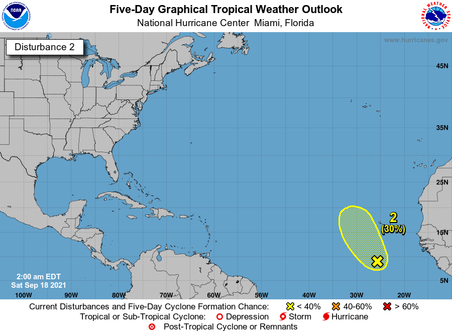
association with a low pressure system located over the far eastern
Atlantic a few hundred miles south-southwest of the Cabo Verde
Islands.  Environmental conditions appear conducive for further
development of this system, and a tropical depression is likely to
form during the next day or two while moving toward the northwest at
10 to 15 mph to the west of the Cabo Verde Islands.  This system is
expected to reach cooler waters and an area of stronger upper-level
winds early next week, which should limit its development.
* Formation chance through 48 hours...high...70 percent.
* Formation chance through 5 days...high...70 percent.
two_atl_2d2.png
97L_BAND01.gif


king111807 發表於 2021-9-19 01:36
NHC展望升至50%
2. A low pressure system located over the far eastern Atlantic a few
hundred miles south-southwest of the Cabo Verde Islands continues
to show some signs of organization.  Environmental conditions
appear conducive for further development of this system, and a
tropical depression could form over the next couple of days while
moving toward the northwest at 10 to 15 mph to the west of the Cabo
Verde Islands.  This system is expected to reach cooler waters and
an area of stronger upper-level winds early next week, which could
limit its development.
* Formation chance through 48 hours...medium...50 percent.
* Formation chance through 5 days...medium...50 percent.
two_atl_2d2.png
king111807 發表於 2021-9-18 22:00
NHC展望提升至Medium,40%
2. A broad area of low pressure is located over the far eastern
Atlantic a few hundred miles south of the Cabo Verde Islands.  The
associated shower and thunderstorm activity has become a little
better organized since yesterday, and environmental conditions
appear conducive for further development during the next couple of
days.  A tropical depression could form while the system moves
northwestward at about 10 mph to the west of the Cabo Verde
Islands before it reaches cooler waters and stronger upper-level
winds early next week.
* Formation chance through 48 hours...medium...40 percent.
* Formation chance through 5 days...medium...40 percent.
two_atl_2d2.png

本平台僅供學術討論之用,預報應以氣象局為準

威普網站虛擬主機贊助公司

臺灣第一個天氣類型社群平台 即時天氣資訊、精準颱風動態

線上客服
FB傳送訊息
廣告行銷
精準行銷 物超所值
官方粉專
發佈 快速回復 返回頂部 返回列表