開啟輔助訪問
 找回密碼
 立即加入

09L.Ian 中心出海 轉向北上

簽到天數: 601 天

[LV.9]以壇為家II

2022-9-21 10:35 | 顯示全部樓層
基本資料  
編號    :98 L
擾動編號日期:2022 09 20 20
撤編日期  :2022 00 00 00
98L.INVEST.25kts-1011mb-10.3N-53.0W
20220920.1230.goes-16.ir.98L.INVEST.25kts.1011mb.10.3N.53W.100pc.jpg
A tropical wave located several hundred miles east of the Windward
Islands is producing a broad area of disorganized showers and
thunderstorms while moving westward at 15-20 mph.  Gradual
development of this system is forecast during the next several days
as the system approaches the Windward Islands, and a tropical
depression could form by the latter part of this week as the system
moves into the eastern and central Caribbean sea.
* Formation chance through 48 hours...low...10 percent.
* Formation chance through 5 days...medium...50 percent.

two_atl_2d2.png
回復

使用道具 舉報

簽到天數: 582 天

[LV.9]以壇為家II

蜜露|2022-9-30 10:49 | 顯示全部樓層
本帖最後由 蜜露 於 2022-9-30 11:05 編輯


颶風伊恩重創佛羅里達州的地方

伊恩登陸的強度是135Kts  4級颱風的上限. 強過2005卡翠娜.

算是滿高的,伊恩登陸美國前10強的颶風

伊恩登陸的地方災情不算高,佛州已經見慣不慣了.

台灣因為地形跟位置的關係,在強的5級颱風到台灣只剩3或4級,地形或台灣海域不利因素先減弱
台灣的歷史上像2016尼伯特、2015蘇迪勒、2000碧利斯、1996賀伯、1994提姆 登陸時可能曾經有保持130kts 4級水平的強度登陸台灣
跟伊恩登陸佛州差不多強.

美國是平原的關係,例如菲律賓跟台灣一樣山地結構很多,但是登陸菲律賓的颱風強度卻是全球第一的.
緯度還是佔優勢,菲律賓是一年四季夏季,靠近菲律賓時颱風反而有利增強.  菲律賓東方的環境更適合發展


2022-09-29T144601Z_143060191_RC2XQW9GK4TY_RTRMADP_3_STORM-IAN-FLORIDA-1024x767.jpg

220929-hurricane-ian-florida-mb-1348-5c10ef.jpg

EPDAKR4DLALGUCPZJSCB4CLORU.jpg

hurricane-ian.jpg

b-6335c3da496d2-scaled.jpg

Tropical_Weather_83792-63358e2b9a6c1-scaled.jpg


12279805_092922ccapianaftermathaerialsftmyers13img.jpeg

12279067_092922-cc-ap-hurricane-ian-ft-myers-img.jpeg


回復

使用道具 舉報

簽到天數: 3279 天

[LV.Master]伴壇終老

t02436|2022-9-29 23:49 | 顯示全部樓層
中心進入大西洋,強度減弱至60節,36小時內再次登陸。
000
WTNT44 KNHC 291500
TCDAT4

Tropical Storm Ian Discussion Number  28
NWS National Hurricane Center Miami FL       AL092022
1100 AM EDT Thu Sep 29 2022

The center of Ian has emerged into the western Atlantic Ocean to
the north of Cape Canaveral.  While satellite images show the
system is becoming a hybrid cyclone, with frontal features outside
of the core of Ian, the winds from multiple sources are notable.  
Velocity data from NWS Doppler radar indicate maximum winds of about
70-75 kt at 10,000 ft over land, and sustained winds of about 55 kt
were recorded in the Daytona Beach area earlier this morning.  These
data support a higher initial intensity, now 60 kt for this
advisory.

The storm is moving northeastward at about 8 kt.  Ian has stubbornly
gone east of the track forecast for the past couple of days and has
moved back over water faster than expected.   A mid-level shortwave
trough moving southward across the southern United States should
turn Ian northward overnight and north-northwestward on Saturday.
The official track forecast is shifted to the east, consistent with
the latest consensus guidance.

Ian should move over the Gulf Stream tonight and tomorrow for a
longer period of time than previously anticipated, which should
maintain Ian's central convection.  Additionally, an increased
pressure gradient on the northwestern side from a stationary front
near the southeastern US, should provide a boost to the wind speeds
on that side of the storm.  We now expect Ian to become a hurricane
again by this evening.  As the system approaches South Carolina, Ian
should maintain this intensity, and Hurricane Warnings have been
issued for the entire coast of South Carolina.  This scenario is
consistent with the global and regional hurricane model guidance.  
It is worth noting that Ian is forecast to have atypical structure
when it nears the southeastern United States, and strong winds will
extend well ahead of the center, even on the northwestern side.


Key Messages:

1. There is a danger of life-threatening storm surge through Friday
along the coasts of northeast Florida, Georgia, and South Carolina.
Residents in these areas should follow any advice given by local
officials.

2. Hurricane-force winds are expected across the South Carolina
coast beginning early Friday, where a Hurricane Warning has been
issued. Hurricane conditions are possible by tonight along the
coasts of northeastern Florida and Georgia, where a Hurricane Watch
is in effect.   Preparations should be rushed to completion since
tropical-storm-force winds will begin well before the center
approaches the coast.

3. Ongoing major-to-record river flooding will continue across
portions of central Florida, with considerable flooding in northern
Florida.  Considerable flash and urban flooding is expected across
coastal portions of northeast Florida through Friday. Local
significant flooding in southeastern Georgia and eastern South
Carolina is expected through the end of the week.


FORECAST POSITIONS AND MAX WINDS

INIT  29/1500Z 28.7N  80.4W   60 KT  70 MPH
12H  30/0000Z 30.0N  79.9W   65 KT  75 MPH
24H  30/1200Z 31.8N  79.8W   65 KT  75 MPH
36H  01/0000Z 34.0N  80.3W   45 KT  50 MPH...INLAND
48H  01/1200Z 35.9N  81.1W   30 KT  35 MPH...POST-TROP/EXTRATROP
60H  02/0000Z 37.0N  82.0W   15 KT  15 MPH...POST-TROP/EXTRATROP
72H  02/1200Z...DISSIPATED

$$
Forecaster Blake

093959_5day_cone_with_line.png

GOES15462022272VLvZAM.jpg
回復

使用道具 舉報

簽到天數: 3279 天

[LV.Master]伴壇終老

t02436|2022-9-28 23:52 | 顯示全部樓層
15Z報維持135節評價,稍後即將以巔峰強襲佛州。

000
WTNT44 KNHC 281458
TCDAT4

Hurricane Ian Discussion Number  24
NWS National Hurricane Center Miami FL       AL092022
1100 AM EDT Wed Sep 28 2022

Air Force Reserve and NOAA Hurricane Hunter data was absolutely
critical this morning in diagnosing the rapid intensification of
Ian, despite both planes undergoing multiple eyewall penetrations
experiencing severe turbulence.  That data supported an intensity of
about 135 kt a few hours ago.  Since that time, high-resolution
Tampa Doppler radar data has been sampling the eyewall near 10,000
ft with winds up to 155 kt, indicating that Ian is on the threshold
of category 5 status.  The maximum winds are set to 135 kt on this
advisory.

Ian is expected to make landfall in southwestern Florida in the next
few hours as a catastrophic hurricane.  No changes were made to the
track forecast near Florida, except to be faster to come into line
with the latest consensus aids.   One important change is that Ian
is likely to remain more intact as it crosses the Florida peninsula
(due to both its stronger initial wind speed and its faster forecast
forward speed), and this now increases the threat of hurricane-force
winds on the east coast of Florida.  This necessitates the issuance
of a Hurricane Warning on the east coast of central Florida.  While
significant re-strengthening of Ian might not occur over the
Atlantic Ocean, model guidance has been catching up with a
trough interaction from a shortwave over the southern United
States, and are stronger than yesterday on Ian's intensity with
more baroclinic forcing.  Thus, a Hurricane Watch has been issued
from northeastern Florida northward up the coast through most of
coastal South Carolina.   The new intensity forecast is raised from
the previous one, near the latest statistical-dynamical guidance.


Key Messages:

1. Catastrophic storm surge inundation of 12 to 18 feet above ground
level along with destructive waves are expected somewhere along the
southwest Florida coastline from Englewood to Bonita Beach,
including Charlotte Harbor. Residents in these areas should urgently
follow any evacuation orders in effect.

2. Catastrophic wind damage is beginning along the southwestern
coast of Florida today near the landfall location.  Hurricane-force
winds are expected to extend well inland along near the core of Ian.
Preparations to protect life and property should be urgently rushed
to completion.

3. Heavy rainfall will spread across the Florida peninsula through
Thursday and reach portions of the Southeast U.S. later this week
and this weekend.  Widespread, life-threatening catastrophic
flooding is expected across portions of central Florida with
considerable flooding in southern Florida, northern Florida,
southeastern Georgia and coastal South Carolina. Widespread,
prolonged major and record river flooding is expected across
central Florida.

4. Hurricane conditions are expected along the east-central Florida
coast overnight, where a Hurricane Warning has been issued.  
Hurricane conditions are possible from northeastern Florida to
portions of South Carolina on Thursday and Friday, and a Hurricane
Watch has been issued for that area.


FORECAST POSITIONS AND MAX WINDS

INIT  28/1500Z 26.3N  82.5W  135 KT 155 MPH
12H  29/0000Z 27.3N  82.1W  105 KT 120 MPH...INLAND
24H  29/1200Z 28.3N  81.4W   60 KT  70 MPH...INLAND
36H  30/0000Z 29.3N  80.8W   55 KT  65 MPH...OVER WATER
48H  30/1200Z 30.8N  80.6W   55 KT  65 MPH...OVER WATER
60H  01/0000Z 32.9N  80.9W   45 KT  50 MPH...INLAND
72H  01/1200Z 34.7N  81.5W   30 KT  35 MPH...POST-TROP/EXTRATROP
96H  02/1200Z 36.0N  81.5W   20 KT  25 MPH...POST-TROP/EXTRATROP
120H  03/1200Z...DISSIPATED

$$
Forecaster Blake

095758_5day_cone_with_line.png

recon_AF301-2609A-IAN.png

recon_AF301-2609A-IAN_timeseries.png

goes16_truecolor_09L_202209281432.gif

GOES15462022271CSjBkY.jpg

GOES15462022271WaXiC2.jpg
回復

使用道具 舉報

簽到天數: 601 天

[LV.9]以壇為家II

霧峰追風者|2022-9-28 20:27 | 顯示全部樓層
NHC 實測後強度升至C4(135KT)
000
WTNT44 KNHC 281057
TCDAT4

Hurricane Ian Special Discussion Number  23
NWS National Hurricane Center Miami FL       AL092022
700 AM EDT Wed Sep 28 2022

This special advisory is being issued to update Ian's current and
forecast intensity.  Recent NOAA and Air Force Reserve Hurricane
Hunter flight-level winds are as high as 160 kt, with SFMR data
around 135 kt, with a central pressure down to 937 mb.  This
supports a current intensity of 135 kt.  

The forecast intensity is raised to 135 kt at landfall, and we are
now forecasting a catastrophic storm surge of 12 to 16 ft from
Englewood to Bonita Beach, Florida.  No other significant changes
were made to the forecast.  

Previous discussion --

Ian completed an eyewall replacement cycle during the overnight
hours, and very recent data from an Air Force Reserve Hurricane
Hunter aircraft indicate that the hurricane has reached category 4
intensity.  The plane reported that the central pressure has fallen
to 942 mb, down about 10 mb from around midnight.  The plane
measured a peak 700-mb flight-level wind of 141 kt, and an SFMR
wind of 109 kt.  A blend of the 700-mb reduced wind and the SFMR
yields an initial intensity of 120 kt.  Although there is some
moderate shear over the hurricane, this is not likely to affect Ian
very much due to its large size. Some fluctuations in intensity are
possible before the center reaches the coast later today, but Ian is
expected to reach the coast as an extremely dangerous category 4
hurricane.  Weakening is expected while Ian moves over the Florida
peninsula.

Ian has jogged a little to the left this morning, but the
longer-term motion remains north-northeastward or 015 degrees
at 9 kt.  The hurricane should continue moving north-northeastward
through Thursday between the western side of a subtropical ridge
and a broad trough over the eastern United States. This motion is
expected to bring the center of Ian onshore along the west coast of
Florida later today, and over central Florida tonight and Thursday.
A shortwave trough that is forecast to move southward toward the
northwestern Gulf in about 24 to 36 hours is expected to sharpen
the trough over the eastern U.S. causing Ian to turn northward
along coast of northeastern Florida and Georgia Thursday night and
Friday.  The model envelope did not change much this cycle, and very
little cross-track adjustments were needed to the official
forecast.  The GFS and ECWMF are noticeably slower than the
remainder of the dynamical models, and the updated NHC track
forecast is a little slower than the previous advisory and slightly
slower than the TVCA consensus aid out of respect for those models.


Key Messages:

1. Catastrophic storm surge inundation of 12 to 16 feet above ground
level along with destructive waves are expected somewhere along the
southwest Florida coastline from Englewood to Bonita Beach,
including Charlotte Harbor. Residents in these areas should urgently
follow any evacuation orders in effect.

2. Catastrophic wind damage is expected along the southwestern
coast of Florida beginning in the next few hours where the core of
Ian makes landfall.  Preparations to protect life and property
should be urgently rushed to completion.

3. Heavy rainfall will spread across the Florida peninsula through
Thursday and reach portions of the Southeast U.S. later this week
and this weekend.  Widespread, life-threatening catastrophic
flooding is expected across portions of central Florida with
considerable flooding in southern Florida, northern Florida,
southeastern Georgia and coastal South Carolina. Widespread,
prolonged major and record river flooding expected across central
Florida.


FORECAST POSITIONS AND MAX WINDS

INIT  28/1100Z 25.9N  82.8W  135 KT 155 MPH
12H  28/1800Z 26.7N  82.4W  135 KT 155 MPH
24H  29/0600Z 27.7N  81.7W   80 KT  90 MPH...INLAND
36H  29/1800Z 28.7N  81.1W   50 KT  60 MPH...INLAND
48H  30/0600Z 29.8N  80.7W   45 KT  50 MPH...OVER WATER
60H  30/1800Z 31.6N  80.8W   45 KT  50 MPH
72H  01/0600Z 33.6N  81.4W   30 KT  35 MPH...INLAND
96H  02/0600Z 36.1N  82.1W   25 KT  30 MPH...POST-TROP/INLAND
120H  03/0600Z...DISSIPATED

$$
Forecaster Blake

095758_5day_cone_no_line_and_wind.png 185703inb3fkjvtnvbxbmd.jpg 185709c66s2v6u8l45zvuo.jpg 20222710500-20222711040-GOES16-ABI-AL092022-GEOCOLOR-1000x1000.gif
回復

使用道具 舉報

簽到天數: 3731 天

[LV.Master]伴壇終老

甜心|2022-9-28 10:56 | 顯示全部樓層
本帖最後由 甜心 於 2022-9-28 11:01 編輯

這傢伙就是現在國際新聞正在發報即將襲美在德州引發逃難潮的伊恩颶風,目前的強度大概是我們這邊的中颱上限45-48m/s先前古巴因為它災情不輕。
回復

使用道具 舉報

簽到天數: 3279 天

[LV.Master]伴壇終老

t02436|2022-9-27 23:50 | 顯示全部樓層
已掃過古巴重新出海,下一站襲向佛州。
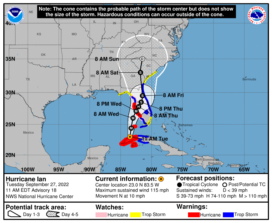
100939_5day_cone_with_line.png
000
WTNT44 KNHC 271500
TCDAT4

Hurricane Ian Discussion Number  18
NWS National Hurricane Center Miami FL       AL092022
1100 AM EDT Tue Sep 27 2022

The well-defined eye of Ian emerged off the coast of western Cuba
about an hour ago.  Earlier reports from the NOAA Hurricane Hunter
aircraft indicate that Ian strengthened up through landfall, with an
estimated pressure of 947 mb over western Cuba.  While the hurricane
has filled somewhat due to the passage over Cuba, Air Force Reserve
and NOAA Hurricane Hunter data show that it has grown in size.  The
initial wind speed is set to 100 kt.

Ian is moving northward, or 005/9 kt. Dropsonde data from the NOAA
G-IV aircraft indicate a potent upper-level trough is over the
western Gulf of Mexico.  The strength of this trough, the associated
southwesterly flow, and the vertical depth of Ian appear to be the
keys to the forecast.  There has been a notable trend toward the
hurricane remaining more intact up through landfall, meaning Ian is
likely to turn to the northeast and not move as slowly as previously
anticipated.  However, it should be emphasized that this track
remains very uncertain, with a typical spread in the steering
features leading to big speed and track differences down the line,
not to mention the oblique angle of approach to Florida.  The latest
forecast is adjusted to the southeast for this advisory, showing
landfall 6-12 hours faster than before, and we will have to see if
the southern trend continues in the afternoon guidance.  The rest of
the forecast after landfall has been adjusted to the northeast as
well, though it is still slower than the consensus guidance at
longer range.

The hurricane should remain in a favorable environment for
restrengthening over the next day or so while it moves over the warm
waters of the southeastern Gulf of Mexico and in light-shear
conditions.  While the shear should increase by tomorrow, it isn't
expected to be enough to significantly weaken the hurricane before
landfall.  Model guidance is in fairly good agreement on this
scenario, and the NHC intensity forecast continues to call for an
extremely dangerous hurricane landfall for southwestern Florida.

The new forecast necessitates a Hurricane Watch for portions of
extreme southwestern Florida, and a Tropical Storm Watch for the
rest of southeastern Florida that wasn't previously under a watch.
Users are reminded to not focus on the exact track as some
additional adjustments to the track are possible. Significant wind,
storm surge, and rainfall hazards will extend far from the center.


Key Messages:

1. Life-threatening storm surge, hurricane-force winds, flash floods
and possible mudslides are expected to continue in portions of
western Cuba today. Devastating wind damage is expected near the
core of Ian.

2. Life-threatening storm surge looks increasingly likely along much
of the Florida west coast where a storm surge warning is in effect,
with the highest risk from Fort Myers to the Tampa Bay region.
Residents in these areas should listen to advice given by local
officials and follow evacuation orders if made for your area.

3. Hurricane-force winds are expected in the hurricane warning area
in southwest and west-central Florida beginning Wednesday morning
with tropical storm conditions expected by this evening.  Residents
should rush all preparations to completion today.

4. Heavy rainfall will increase across the Florida Keys and south
Florida today, spreading into central and northern Florida tonight
and Wednesday, into the Southeast U.S.  by Thursday and Friday,
likely causing flash, urban, and small stream flooding. Considerable
flooding is expected across central Florida into southern Georgia
and coastal South Carolina, with widespread, prolonged moderate to
major river flooding expected across central Florida.


FORECAST POSITIONS AND MAX WINDS

INIT  27/1500Z 23.0N  83.5W  100 KT 115 MPH
12H  28/0000Z 24.4N  83.3W  115 KT 130 MPH
24H  28/1200Z 26.0N  83.0W  115 KT 130 MPH
36H  29/0000Z 27.1N  82.5W  110 KT 125 MPH
48H  29/1200Z 27.8N  82.1W   75 KT  85 MPH...INLAND
60H  30/0000Z 28.5N  81.7W   60 KT  70 MPH...INLAND
72H  30/1200Z 29.5N  81.5W   50 KT  60 MPH...INLAND
96H  01/1200Z 33.0N  81.8W   35 KT  40 MPH...INLAND
120H  02/1200Z 35.0N  81.5W   25 KT  30 MPH...POST-TROP/EXTRATROP

$$
Forecaster Blake
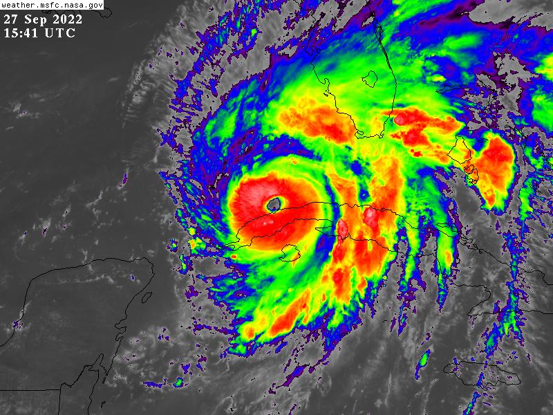
GOES15412022270yKKAPH.jpg
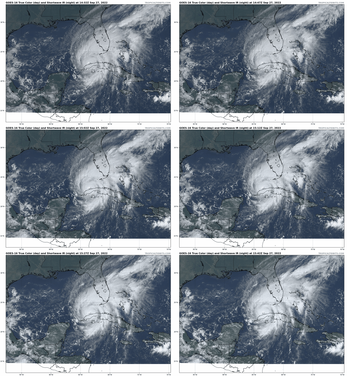
goes16_truecolor_09L_202209271432.gif
回復

使用道具 舉報

簽到天數: 601 天

[LV.9]以壇為家II

霧峰追風者|2022-9-27 12:41 | 顯示全部樓層
000
WTNT44 KNHC 270258
TCDAT4

Hurricane Ian Discussion Number  16
NWS National Hurricane Center Miami FL       AL092022
1100 PM EDT Mon Sep 26 2022

Ian continues to become better organized on satellite images with
intense deep convection in its Central Dense Overcast and numerous
surrounding banding features.  The overall cloud pattern is quite
symmetric with well-defined upper-level outflow.  Observations from
both Air Force and NOAA Hurricane Hunter aircraft indicate that the
central pressure is falling, and the intensity is increased to 90
kt based on a recently reported 700 mb flight-level wind of 101 kt
from the Air Force plane.  This is also in agreement with a
subjective Dvorak satellite estimate from SAB.

Aside from its relatively brief time passing over western Cuba, Ian
will be moving over waters of very high oceanic heat content during
the next couple of days.  The various Rapid Intensification (RI)
indices show a significant probability of RI and this is reflected
in the short-term official intensity forecast.  However, the SHIPS
guidance, which is based on global model predictions, indicates that
a significant increase in southwesterly shear and a substantially
drying of low- to mid-level air will begin in 24-36 hours.  The NHC
forecast, like the previous one, shows strengthening to Category 4
intensity in a day or so, followed by gradual weakening.  However,
Ian is still expected to be a major hurricane when it reaches the
Florida west coast.  The official intensity forecast is near or
above the latest simple and corrected multi-model consensus
predictions.

Ian continues its north-northwestward trek at about 340/11 kt.  The
hurricane is expected to move north-northwestward to northward
over the southeastern Gulf of Mexico during the next day or so,
along the western periphery of a subtropical ridge.  After around
36 hours, the track forecast becomes more uncertain, since there is
considerable divergence of the track  models in the 2-3 day
time frame.  The guidance also shows considerable slowing of the
forward speed, due to a weakening of the steering currents, when
Ian approaches the west coast of Florida.  This slower forward
motion is likely to prolong the storm surge, wind, and rainfall
impacts, especially along the west coast of Florida.  The official
track forecast is adjusted just slightly east of the previous NHC
prediction based on the latest multi-model consensus aid, TVCN.


Key Messages:

1. Life-threatening storm surge, hurricane-force winds, flash floods
and possible mudslides are expected in portions of western Cuba
beginning overnight and continuing into Tuesday. Devastating wind
damage is possible where the core of Ian moves across western Cuba.
Efforts to protect life and property should be rushed to completion.

2. There is a danger of life-threatening storm surge along much
of the Florida west coast where a storm surge warning has been
issued, with the highest risk from Fort Myers to the Tampa Bay
region.  Residents in these areas should listen to advice given by
local officials.

3. Hurricane-force winds are expected in the hurricane warning area
in west-central Florida beginning Wednesday morning with tropical
storm conditions expected by late Tuesday.

4. Heavy rainfall will spread across western Cuba through Tuesday.  
This will likely produce instances of flash flooding and possible
mudslides in areas of higher terrain over western Cuba.  

5. Heavy rainfall will increase across the Florida Keys and South
Florida Tuesday, spreading into central and northern Florida
Wednesday and Thursday and the Southeast by Friday and Saturday,
potentially causing flash, urban and small stream flooding.
Considerable flooding, including significant, prolonged river
flooding, is likely across Central Florida.


FORECAST POSITIONS AND MAX WINDS

INIT  27/0300Z 21.3N  83.4W   90 KT 105 MPH
12H  27/1200Z 22.8N  83.7W  105 KT 120 MPH
24H  28/0000Z 24.5N  83.7W  120 KT 140 MPH
36H  28/1200Z 26.1N  83.5W  115 KT 130 MPH
48H  29/0000Z 27.2N  83.1W  105 KT 120 MPH
60H  29/1200Z 27.9N  82.7W   95 KT 110 MPH...INLAND
72H  30/0000Z 28.6N  82.4W   65 KT  75 MPH...INLAND
96H  01/0000Z 31.3N  82.2W   30 KT  35 MPH...INLAND
120H  02/0000Z 35.0N  81.5W   25 KT  30 MPH...INLAND

$$
Forecaster Pasch
223342_5day_cone_with_line_and_wind.png recon_AF301-1809A-IAN.png 20222692200-20222700340-GOES16-ABI-AL092022-GEOCOLOR-1000x1000.gif
回復

使用道具 舉報

12下一頁
快速回覆
您需要登錄後才可以回帖 登錄 | 立即加入

本版積分規則

霧峰追風者

    主題

    帖子

    220萬

    積分

    16級[四級颶風]

    Rank: 16Rank: 16Rank: 16Rank: 16

16級[四級颶風]

發訊息

本平台僅供學術討論之用,預報應以氣象局為準

威普網站虛擬主機贊助公司

臺灣第一個天氣類型社群平台 即時天氣資訊、精準颱風動態

線上客服
FB傳送訊息
廣告行銷
精準行銷 物超所值
官方粉專
發佈 快速回復 返回頂部 返回列表