開啟輔助訪問
 找回密碼
 立即加入

05L.Dorian 年度風王 巔峰強襲巴哈馬群島

簽到天數: 1650 天

[LV.Master]伴壇終老

2019-8-23 19:46 | 顯示全部樓層
  基本資料  
編號    :05 L
擾動編號日期:2019 08 23 19
撤編日期  :2019 09 10 10
99L INVEST 190823 0600 9.5N 40.5W ATL 20 1012

20190823.1120.goes-16.ir.99L.INVEST.15kts.1006mb.10N.41.5W.100pc.jpg

  NHC:10%  
2. Showers and thunderstorms have increased since yesterday in
association with a tropical wave located about 1400 miles
east-southeast of the Windward Islands.  Additional slow development
of this system is possible during the next few days as it moves
generally westward at about 15 mph.
* Formation chance through 48 hours...low...10 percent.
* Formation chance through 5 days...low...20 percent.

two_atl_2d20823.png
two_atl_5d20823.png

-MAX:160KT 911hPa
-猛爆增強登年度風王 強襲巴哈馬群島

評分

參與人數 1水氣能量 +15 +1 收起 理由
king111807 + 15 + 1 熱帶擾動首帖

查看全部評分

回復

使用道具 舉報

簽到天數: 53 天

[LV.5]常住居民I

天篷大元帥|2019-8-23 20:08 | 顯示全部樓層
國家颶風中心:
兩天內10%
五天內20%
(圖一:https://www.tropicaltidbits.com/storminfo/ ;圖二:國家颶風中心)

電腦模擬(GFS Ensembles)

電腦模擬(GFS Ensembles)

國家颶風中心

國家颶風中心

點評

少數先編號後NHC或CPHC才有資訊出現的擾動系統  發表於 2019-8-23 20:27
回復

使用道具 舉報

簽到天數: 1650 天

[LV.Master]伴壇終老

老農民版夜神月|2019-8-24 02:11 | 顯示全部樓層
NHC展望快速上升為Medium,40%/50%
2. Recent satellite wind data indicate that a low pressure area has
formed in association with a tropical wave located about 1300
miles east-southeast of the Windward Islands. Additional
development of this system is possible during the next few days, and
a tropical depression could form late this weekend or early next
week as it moves generally westward to west-northwestward near 15
mph.
* Formation chance through 48 hours...medium...40 percent.
* Formation chance through 5 days...medium...50 percent.

two_atl_2d20808.png two_atl_5d20808.png

LATEST0808.jpg
回復

使用道具 舉報

簽到天數: 1650 天

[LV.Master]伴壇終老

老農民版夜神月|2019-8-24 23:16 | 顯示全部樓層
NHC24/1500Z升格TD,預測路徑五天內穩定西轉西北的朝向西印度群島移動
000
WTNT25 KNHC 241440
TCMAT5

TROPICAL DEPRESSION FIVE FORECAST/ADVISORY NUMBER 1
NWS NATIONAL HURRICANE CENTER MIAMI FL AL052019
1500 UTC SAT AUG 24 2019

THERE ARE NO COASTAL WATCHES OR WARNINGS IN EFFECT.

INTERESTS IN THE CENTRAL AND NORTHERN LESSER ANTILLES SHOULD MONITOR
THE PROGRESS THIS SYSTEM.

TROPICAL DEPRESSION CENTER LOCATED NEAR 10.4N 47.9W AT 24/1500Z
POSITION ACCURATE WITHIN 20 NM

PRESENT MOVEMENT TOWARD THE WEST OR 280 DEGREES AT 10 KT

ESTIMATED MINIMUM CENTRAL PRESSURE 1010 MB
MAX SUSTAINED WINDS 30 KT WITH GUSTS TO 35 KT.
WINDS AND SEAS VARY GREATLY IN EACH QUADRANT. RADII IN NAUTICAL
MILES ARE THE LARGEST RADII EXPECTED ANYWHERE IN THAT QUADRANT.

REPEAT...CENTER LOCATED NEAR 10.4N 47.9W AT 24/1500Z
AT 24/1200Z CENTER WAS LOCATED NEAR 10.3N 47.4W

FORECAST VALID 25/0000Z 10.7N 49.4W
MAX WIND 30 KT...GUSTS 40 KT.

FORECAST VALID 25/1200Z 11.0N 51.4W
MAX WIND 35 KT...GUSTS 45 KT.
34 KT... 30NE 0SE 0SW 30NW.

FORECAST VALID 26/0000Z 11.4N 53.5W
MAX WIND 40 KT...GUSTS 50 KT.
34 KT... 30NE 0SE 0SW 30NW.

FORECAST VALID 26/1200Z 12.0N 55.5W
MAX WIND 45 KT...GUSTS 55 KT.
34 KT... 30NE 30SE 0SW 30NW.

FORECAST VALID 27/1200Z 13.6N 59.3W
MAX WIND 55 KT...GUSTS 65 KT.
50 KT... 20NE 0SE 0SW 20NW.
34 KT... 40NE 40SE 30SW 40NW.

EXTENDED OUTLOOK. NOTE...ERRORS FOR TRACK HAVE AVERAGED NEAR 150 NM
ON DAY 4 AND 175 NM ON DAY 5...AND FOR INTENSITY NEAR 15 KT EACH DAY

OUTLOOK VALID 28/1200Z 15.2N 63.1W
MAX WIND 65 KT...GUSTS 80 KT.

OUTLOOK VALID 29/1200Z 17.1N 66.7W
MAX WIND 75 KT...GUSTS 90 KT.

REQUEST FOR 3 HOURLY SHIP REPORTS WITHIN 300 MILES OF 10.4N 47.9W

NEXT ADVISORY AT 24/2100Z

$$
FORECASTER STEWART

144923_5day_cone_no_line_and_wind.png 20190824.1430.goes-16.ir.99L.INVEST.25kts.1011mb.10.3N.47.4W.100pc.jpg
LATEST0823.jpg

回復

使用道具 舉報

簽到天數: 1650 天

[LV.Master]伴壇終老

老農民版夜神月|2019-8-25 09:09 | 顯示全部樓層
本帖最後由 老農民版夜神月 於 2019-8-27 23:08 編輯

NHC24/21Z升格TS,命名Dorian,巔峰暫時上望颶風75節
000
WTNT25 KNHC 242042
TCMAT5

TROPICAL STORM DORIAN FORECAST/ADVISORY NUMBER 2
NWS NATIONAL HURRICANE CENTER MIAMI FL AL052019
2100 UTC SAT AUG 24 2019

THERE ARE NO COASTAL WATCHES OR WARNINGS IN EFFECT.

INTERESTS IN THE CENTRAL AND NORTHERN LESSER ANTILLES SHOULD
MONITOR THE PROGRESS OF DORIAN.

TROPICAL STORM CENTER LOCATED NEAR 10.7N 49.1W AT 24/2100Z
POSITION ACCURATE WITHIN 20 NM

PRESENT MOVEMENT TOWARD THE WEST OR 280 DEGREES AT 10 KT

ESTIMATED MINIMUM CENTRAL PRESSURE 1008 MB
MAX SUSTAINED WINDS 35 KT WITH GUSTS TO 45 KT.
34 KT....... 20NE 0SE 0SW 20NW.
WINDS AND SEAS VARY GREATLY IN EACH QUADRANT. RADII IN NAUTICAL
MILES ARE THE LARGEST RADII EXPECTED ANYWHERE IN THAT QUADRANT.

REPEAT...CENTER LOCATED NEAR 10.7N 49.1W AT 24/2100Z
AT 24/1800Z CENTER WAS LOCATED NEAR 10.6N 48.6W

FORECAST VALID 25/0600Z 11.0N 50.7W
MAX WIND 40 KT...GUSTS 50 KT.
34 KT... 30NE 0SE 0SW 30NW.

FORECAST VALID 25/1800Z 11.4N 52.8W
MAX WIND 45 KT...GUSTS 55 KT.
34 KT... 30NE 30SE 0SW 30NW.

FORECAST VALID 26/0600Z 11.9N 54.9W
MAX WIND 50 KT...GUSTS 60 KT.
50 KT... 20NE 0SE 0SW 20NW.
34 KT... 40NE 30SE 20SW 40NW.

FORECAST VALID 26/1800Z 12.7N 57.0W
MAX WIND 55 KT...GUSTS 65 KT.
50 KT... 20NE 0SE 0SW 20NW.
34 KT... 40NE 40SE 20SW 40NW.

FORECAST VALID 27/1800Z 14.6N 61.1W
MAX WIND 65 KT...GUSTS 80 KT.
50 KT... 30NE 20SE 10SW 30NW.
34 KT... 60NE 50SE 30SW 60NW.

EXTENDED OUTLOOK. NOTE...ERRORS FOR TRACK HAVE AVERAGED NEAR 150 NM
ON DAY 4 AND 175 NM ON DAY 5...AND FOR INTENSITY NEAR 15 KT EACH DAY

OUTLOOK VALID 28/1800Z 16.5N 65.3W
MAX WIND 75 KT...GUSTS 90 KT.

OUTLOOK VALID 29/1800Z 18.4N 69.0W...INLAND
MAX WIND 70 KT...GUSTS 85 KT.

REQUEST FOR 3 HOURLY SHIP REPORTS WITHIN 300 MILES OF 10.7N 49.1W

NEXT ADVISORY AT 25/0300Z

$$
FORECASTER STEWART

205313_5day_cone_with_line_and_wind.png al052019.20190824210304.gif
goes16_vis-swir_05L_201908250035.jpg goes16_ir_05L_201908250035.jpg
GOES14502019239DcHxQI.jpg

回復

使用道具 舉報

簽到天數: 1650 天

[LV.Master]伴壇終老

老農民版夜神月|2019-8-28 12:44 | 顯示全部樓層
本帖最後由 老農民版夜神月 於 2019-8-28 13:01 編輯

Dorian將於明日通過波多黎各陸地,近48小時強度將受此影響而有略微的減弱,NHC預測巔峰將出現於美國東南外海,達70節,隨後將以一級颶風下限強度侵襲佛羅里達州
000
WTNT25 KNHC 280249
TCMAT5

TROPICAL STORM DORIAN FORECAST/ADVISORY NUMBER 15
NWS NATIONAL HURRICANE CENTER MIAMI FL AL052019
0300 UTC WED AUG 28 2019

CHANGES IN WATCHES AND WARNINGS WITH THIS ADVISORY...

THE GOVERNMENT OF ANTIGUA HAS ISSUED A TROPICAL STORM WARNING FOR
THE BRITISH VIRGIN ISLANDS.

THE GOVERNMENT OF THE DOMINICAN REPUBLIC HAS CHANGED THE TROPICAL
STORM WARNING TO A TROPICAL STORM WATCH FROM ISLA SAONA TO SAMANA.

SUMMARY OF WATCHES AND WARNINGS IN EFFECT...

A HURRICANE WATCH IS IN EFFECT FOR...
* PUERTO RICO

A TROPICAL STORM WARNING IS IN EFFECT FOR...
* PUERTO RICO
* VIEQUES
* CULEBRA
* U.S. VIRGIN ISLANDS
* BRITISH VIRGIN ISLANDS
* DOMINICAN REPUBLIC FROM ISLA SAONA TO SAMANA

A TROPICAL STORM WATCH IS IN EFFECT FOR...
* DOMINICAN REPUBLIC FROM ISLA SAONA TO PUERTO PLATA

A HURRICANE WATCH MEANS THAT HURRICANE CONDITIONS ARE POSSIBLE
WITHIN THE WATCH AREA...IN THIS CASE WITHIN 24 HOURS.

A TROPICAL STORM WARNING MEANS THAT TROPICAL STORM CONDITIONS ARE
EXPECTED SOMEWHERE WITHIN THE WARNING AREA...IN THIS CASE WITHIN 24
HOURS.

A TROPICAL STORM WATCH MEANS THAT TROPICAL STORM CONDITIONS ARE
POSSIBLE WITHIN THE WATCH AREA...IN THIS CASE WITHIN 24 HOURS.

TROPICAL STORM CENTER LOCATED NEAR 16.0N 63.0W AT 28/0300Z
POSITION ACCURATE WITHIN 20 NM

PRESENT MOVEMENT TOWARD THE NORTHWEST OR 310 DEGREES AT 11 KT

ESTIMATED MINIMUM CENTRAL PRESSURE 1006 MB
MAX SUSTAINED WINDS 45 KT WITH GUSTS TO 55 KT.
34 KT....... 40NE 30SE 0SW 40NW.
12 FT SEAS.. 45NE 30SE 15SW 45NW.
WINDS AND SEAS VARY GREATLY IN EACH QUADRANT. RADII IN NAUTICAL
MILES ARE THE LARGEST RADII EXPECTED ANYWHERE IN THAT QUADRANT.

REPEAT...CENTER LOCATED NEAR 16.0N 63.0W AT 28/0300Z
AT 28/0000Z CENTER WAS LOCATED NEAR 15.8N 62.7W

FORECAST VALID 28/1200Z 17.0N 64.5W
MAX WIND 55 KT...GUSTS 65 KT.
50 KT... 20NE 0SE 0SW 20NW.
34 KT... 40NE 30SE 20SW 40NW.

FORECAST VALID 29/0000Z 18.5N 66.5W
MAX WIND 45 KT...GUSTS 55 KT.
34 KT... 50NE 30SE 20SW 40NW.

FORECAST VALID 29/1200Z 20.3N 68.1W
MAX WIND 50 KT...GUSTS 60 KT.
50 KT... 20NE 0SE 0SW 20NW.
34 KT... 50NE 30SE 20SW 40NW.

FORECAST VALID 30/0000Z 22.1N 69.6W
MAX WIND 55 KT...GUSTS 65 KT.
50 KT... 30NE 10SE 0SW 20NW.
34 KT... 50NE 30SE 20SW 40NW.

FORECAST VALID 31/0000Z 25.3N 72.7W
MAX WIND 65 KT...GUSTS 80 KT.
50 KT... 30NE 20SE 10SW 30NW.
34 KT... 60NE 50SE 40SW 60NW.

EXTENDED OUTLOOK. NOTE...ERRORS FOR TRACK HAVE AVERAGED NEAR 150 NM
ON DAY 4 AND 175 NM ON DAY 5...AND FOR INTENSITY NEAR 15 KT EACH DAY

OUTLOOK VALID 01/0000Z 27.4N 76.8W
MAX WIND 70 KT...GUSTS 85 KT.

OUTLOOK VALID 02/0000Z 28.8N 81.0W...INLAND
MAX WIND 65 KT...GUSTS 80 KT.

REQUEST FOR 3 HOURLY SHIP REPORTS WITHIN 300 MILES OF 16.0N 63.0W

INTERMEDIATE PUBLIC ADVISORY...WTNT35 KNHC/MIATCPAT5...AT 28/0600Z

NEXT ADVISORY AT 28/0900Z

$$
FORECASTER PASCH

AL052019_5day_cone_no_line_and_wind.png al052019.20190828034639.gif
20190828.0400.goes-16.ir.05L.DORIAN.45kts.1003mb.15.8N.62.7W.100pc.jpg GOES04202019240cFZRLG.jpg

回復

使用道具 舉報

簽到天數: 1650 天

[LV.Master]伴壇終老

老農民版夜神月|2019-8-29 00:52 | 顯示全部樓層
本帖最後由 老農民版夜神月 於 2019-8-29 01:02 編輯

就目前最新資訊顯示,Dorian於侵襲波多黎各時將不會登陸,後續受陸地影響而會略為減弱的預報同時遭調整.而後期接近美國佛羅里達州時的強度NHC於此報中上看C3,假如NHC此預報成真,Dorian將成為今年北大西洋首個MH
WTNT45 KNHC 281510 CCA
TCDAT5

Tropical Storm Dorian Discussion Number 17...CORRECTED
NWS National Hurricane Center Miami FL AL052019
1100 AM AST Wed Aug 28 2019

Corrected day 5 intensity forecast in table.

Satellite and radar images indicate that the cloud pattern has
become better organized during the past several hours. This was
confirmed by data from an Air Force reconnaissance plane currently
investigating Dorian, which reported a flight-level wind of 72 kt
and a peak SFMR value of 60 kt. The estimated central pressure was
999 mb in the last fix. On this basis the initial intensity has
been adjusted upward to 60 kt. Only a slow strengthening is
anticipated today while Dorian is moving through the U.S. and
British Virgin Islands. However, once the cyclone reaches the
western Atlantic well east of the Bahamas, it will encounter a
favorable environment of low shear and warm waters, resulting in a
more marked intensification. The NHC foreast is more aggressive than
the previous one, and brings Dorian to category 3 intensity by the
end of the period. This forecast very closely follows the intensity
consensus, the HCCA model, and the SHIPS guidance.

Fixes from the reconnaissance plane indicate that Dorian has been
moving toward the northwest or 315 degrees at 11 kt. The cyclone is
heading toward a weakness in the Atlantic subtropical ridge, and
this motion should continue for the next 2 to 3 days. However, after
that time, all global models build a robust ridge over the western
Atlantic, and this flow pattern should force Dorian to turn more
to the west-northwest toward Florida and the southeast coast of the
United States. All indications are that by this Labor Day weekend, a
powerful hurricane will be near the Florida or southeastern coast of
the United States. The new NHC track forecast is not significantly
different from the previous one, and it very closely follows the
multi-model consensus TVCA and the HCCA. Users are reminded not to
focus on the exact forecast track, as the average 5-day track error
is around 200 miles.

Key Messages:

1. Hurricane conditions are expected in the U.S. and British Virgin
Islands, Culebra, and Vieques today. Tropical storm conditions are
expected in Puerto Rico today with hurricane conditions possible.

2. Heavy rainfall over portions of Puerto Rico and the U.S. and
British Virgin Islands could produce flash flooding during the next
couple of days. Heavy rains are expected to occur over portions of
the Bahamas, Florida, and elsewhere in the southeastern Untied
States later this week and into early next week.

3. The risk of dangerous storm surge and hurricane-force winds is
increasing in the central and northwestern Bahamas and along the
Florida east coast, although it is too soon to determine where these
hazards will occur. Residents in these areas should ensure that
they have their hurricane plan in place and not focus on the exact
forecast track of Dorian's center.


FORECAST POSITIONS AND MAX WINDS

INIT 28/1500Z 17.5N 64.5W 60 KT 70 MPH
12H 29/0000Z 18.7N 65.7W 65 KT 75 MPH
24H 29/1200Z 20.5N 67.0W 65 KT 75 MPH
36H 30/0000Z 22.4N 68.4W 70 KT 80 MPH
48H 30/1200Z 24.2N 69.9W 75 KT 85 MPH
72H 31/1200Z 26.5N 74.0W 90 KT 105 MPH
96H 01/1200Z 27.7N 77.7W 100 KT 115 MPH
120H 02/1200Z 28.6N 80.3W 100 KT 115 MPH

$$
Forecaster Avila
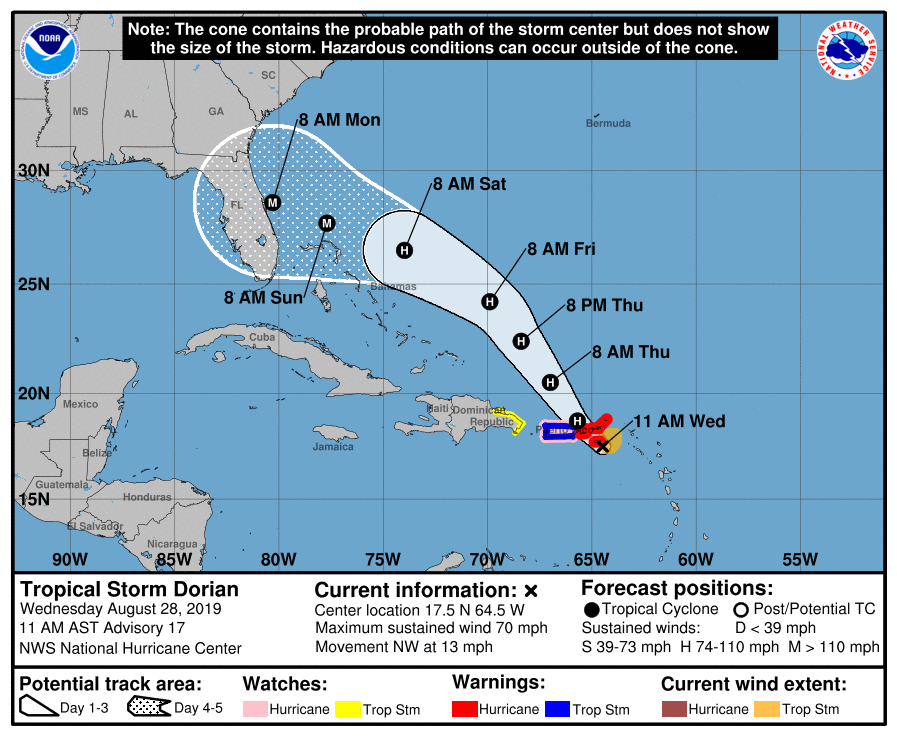
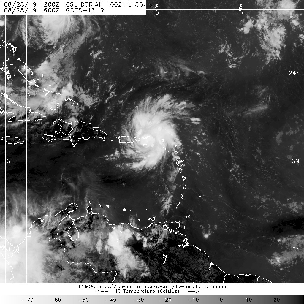
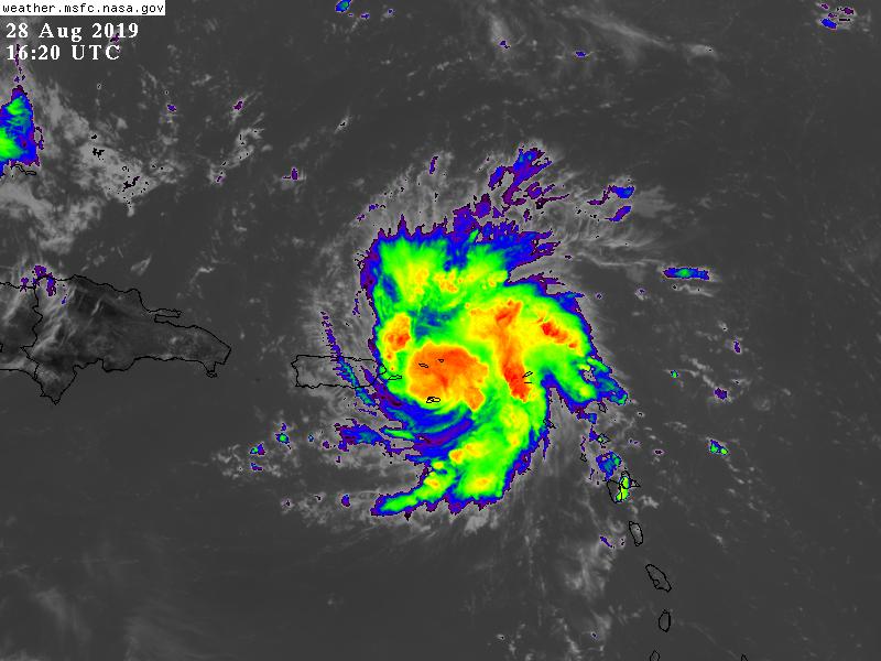
151450_5day_cone_no_line_and_wind.png 20190828.1600.goes-16.ir.05L.DORIAN.55kts.1002mb.17.1N.64.1W.100pc.jpg
GOES162020192402lTpyk.jpg


回復

使用道具 舉報

簽到天數: 3290 天

[LV.Master]伴壇終老

t02436|2019-8-29 01:07 | 顯示全部樓層
補個風場掃描
LATEST.jpg

最新飛機實測測得63節強度,18Z報可能再調升強度
recon_AF309-0905A-DORIAN_timeseries.png

recon_AF309-0905A-DORIAN.png
回復

使用道具 舉報

12345下一頁
快速回覆
您需要登錄後才可以回帖 登錄 | 立即加入

本版積分規則

本平台僅供學術討論之用,預報應以氣象局為準

威普網站虛擬主機贊助公司

臺灣第一個天氣類型社群平台 即時天氣資訊、精準颱風動態

線上客服
FB傳送訊息
廣告行銷
精準行銷 物超所值
官方粉專
發佈 快速回復 返回頂部 返回列表