開啟輔助訪問
 找回密碼
 立即加入

25S.Lorna 加速南下 逐漸轉化

簽到天數: 601 天

[LV.9]以壇為家II

霧峰追風者|2019-4-22 06:22 | 顯示全部樓層
本帖最後由 霧峰追風者 於 2019-4-22 06:32 編輯

JTWC 17Z評級提升至Medium
(1) THE AREA OF CONVECTION (INVEST 90S) PREVIOUSLY LOCATED
NEAR 4.2S 79.5E, IS NOW LOCATED NEAR 4.0S 80.2E, APPROXIMATELY 509
NM EAST-NORTHEAST OF DIEGO GARCIA. A 211538Z ASCAT PASS REVEALS AN
AREA OF 25-30 KNOTS WINDS TO THE NORTHEAST. ANIMATED ENHANCED
INFRARED SATELLITE IMAGERY AND A 211606Z MHS 89GHZ MICROWAVE IMAGE
DEPICT A CONSOLIDATING LOW LEVEL CIRCULATION (LLC) WITH CONVECTION
AROUND THE CENTER.  UPPER-LEVEL ENVIRONMENTAL ANALYSIS SHOWS LOW
VERTICAL WIND SHEAR (5-10 KNOTS) AND A POINT SOURCE ALOFT IS
ENHANCING OUTFLOW. SEA SURFACE TEMPERATURES (28-29 CELSIUS) WILL
HELP FURTHER DEVELOPMENT. GLOBAL MODELS INDICATE SOUTHEASTWARD
INITIAL MOTION OVER THE NEXT 36-48 HOURS WITH GRADUAL
INTENSIFICATION TO TROPICAL CYCLONE STRENGTH, WITH VARYING TIME
FRAMES AND INTENSITY. IT IS POSSIBLE 90S WILL INTERACT WITH AND
ABSORB A CIRCULATION TO THE SOUTHEAST BEFORE CONSOLIDATING. MAXIMUM
SUSTAINED SURFACE WINDS ARE ESTIMATED AT 20 TO 25 KNOTS. MINIMUM SEA
LEVEL PRESSURE IS ESTIMATED TO BE NEAR 1004 MB. THE POTENTIAL FOR
THE DEVELOPMENT OF A SIGNIFICANT TROPICAL CYCLONE WITHIN THE NEXT 24
HOURS IS UPGRADED TO MEDIUM.
abpwsair.jpg 20190421.2150.himawari-8.ir.90S.INVEST.25kts.1004mb.4S.80.2E.100pc.jpg 90S_gefs_latest.png
回復

使用道具 舉報

簽到天數: 601 天

[LV.9]以壇為家II

霧峰追風者|2019-4-21 22:25 | 顯示全部樓層
JTWC 14Z評級LOW
   (1) AN AREA OF CONVECTION (INVEST 90S) HAS PERSISTED NEAR 4.2S
79.5E, APPROXIMATELY 460 NM EAST-NORTHEAST OF DIEGO GARCIA.  
ANIMATED MULTISPECTRAL SATELLITE IMAGERY AND A 211208Z SSMIS 91GHZ
COLOR COMPOSITE MICROWAVE IMAGE SHOW FLARING AND DISORGANIZED
DEEP CONVECTION ASSOCIATED WITH A BROAD, SLOWLY-EVOLVING
DISTURBANCE. UPPER-LEVEL ANALYSIS SHOWS FAVORABLE CONDITIONS WITH
LOW VERTICAL WIND SHEAR (5-10 KNOTS) AND STRONG DIFFLUENCE. SEA
SURFACE TEMPERATURES ARE FAVORABLE AT 29-30C. GLOBAL MODELS INDICATE
A SOUTHEASTWARD TO SOUTHWARD TRACK OVER THE NEXT FEW DAYS WITH THE
SYSTEM REACHING TROPICAL STORM STATUS IN 60-84 HOURS. MAXIMUM
SUSTAINED SURFACE WINDS ARE ESTIMATED AT 20 TO 25 KNOTS.
MINIMUM SEA LEVEL PRESSURE IS ESTIMATED TO BE NEAR 1004 MB. THE
POTENTIAL FOR THE DEVELOPMENT OF A SIGNIFICANT TROPICAL CYCLONE
WITHIN THE NEXT 24 HOURS IS LOW.
abpwsair.jpg

回復

使用道具 舉報

簽到天數: 601 天

[LV.9]以壇為家II

霧峰追風者|2019-4-21 07:54 | 顯示全部樓層
The basin is in a near-equatorial trough (NET) pattern axed near 5S, with westerly winds at the
equator. Near 65E, the NET is broken into two branches, probably because of the passage of a dry
phase of a mixed Rossby-Gravity wave. A moderate convective activity is concentrated within these
two branches of NET : to the North-East of Madagasar and East of Diego Garcia. The development
of two suspect areas within both NET branches is suggested by the available guidance.

North of Madagascar :
From tomorrow, the upper divergence becomes excellent over the western NET branch. Monday, a
weak clockwise circulation could appear and gradually develop from Tuesday. Both the Euro and
American deterministic models are suggesting the formation of a significant tropical low from
Wednesday, North of the Mozambique Channel. This cyclogenesis risk is also shown within the
ensemble members of the last probabilistic runs. However, the lack of equatorward low-level
convergence could slow down the development of the system and keep it at a moderate intensity at
first.
For the next five days, the risk of formation of a moderate tropical storm becomes low
Thursday north of the Comoros archipelago.

East of Diego Garcia :
Benefiting from conducive environmental conditions aloft and from a good low-level convergence,
a clockwise circulation should emerge within the Eastern NET branch by the end of the week-end.
From Tuesday, the strengthening upper divergence should allow the development of the system. The
available guidance is in good agreement to forecast a moderate cyclogenesis risk for the second half
of next week.
For the next five days, the risk of formation of a moderate tropical storm becomes low
Wednesday then moderate from Thursday east of Diego Garcia.
The strengthening of the cyclonic activity expected next week over the basin is probably linked to
the combined passages of a Kelvin and an Equatorial Rossby waves.
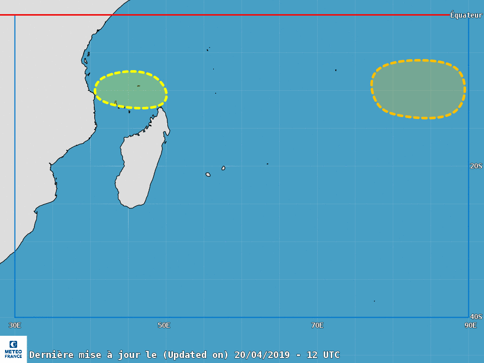
79_105061_3a3107528d02238.png

點評

不要只丟報文或圖片上來(會被當洗版文懲處),可以打上自己的看法  發表於 2019-4-25 16:26
回復

使用道具 舉報

123
快速回覆
您需要登錄後才可以回帖 登錄 | 立即加入

本版積分規則

本平台僅供學術討論之用,預報應以氣象局為準

威普網站虛擬主機贊助公司

臺灣第一個天氣類型社群平台 即時天氣資訊、精準颱風動態

線上客服
FB傳送訊息
廣告行銷
精準行銷 物超所值
官方粉專
發佈 快速回復 返回頂部 返回列表