開啟輔助訪問
 找回密碼
 立即加入

07E.Guillermo 短暫發展

查看數: 7402 評論數: 9 收藏 0切换到帖子模式
    組圖打開中,請稍候......
發佈時間: 2021-7-15 20:35

正文摘要:

  熱帶風暴   編號:07 E 名稱:Guillermo 以上資料來自:NHC、颱風論壇整理製作

老農民版夜神月 發表於 2021-7-21 05:04
本帖最後由 老農民版夜神月 於 2021-7-21 10:45 編輯

NHC判定已減弱為殘餘低氣壓
467
WTPZ42 KNHC 202034
TCDEP2

Post-Tropical Cyclone Guillermo Discussion Number  14
NWS National Hurricane Center Miami FL       EP072021
200 PM PDT Tue Jul 20 2021

Guillermo's circulation consists of a tight swirl of low-level
clouds, and the earlier brief convective flare up dissipated
shortly after the release of the previous advisory.  Given that
the system has been devoid of organized deep convection for most of
the last 18 hours, the system is now considered a remnant low and
this will be the last NHC advisory.   The initial intensity remains
30 kt based on a recent ASCAT pass that showed an area of 25-30 kt
winds north of the center.

The post-tropical cyclone will remain in an dry, stable airmass
while moving over SSTs of 24-25C, which should result in a gradual
spin down of the circulation. Global model fields indicate that the
low will open up into a trough within 48-60 hours, and that is
indicated in the official forecast.

The remnant low is now moving a little south of due west, with an
initial motion estimate of 265/15. The system is expected to move  
west-southwestward until dissipation under the influence of the
expansive low-level ridge centered over the north-central Pacific.
The new NHC track forecast is a little south of and faster than the
previous one, trending toward the latest consensus aids.

FORECAST POSITIONS AND MAX WINDS

INIT  20/2100Z 18.7N 126.5W   30 KT  35 MPH...POST-TROP/REMNT LOW
12H  21/0600Z 18.2N 128.9W   25 KT  30 MPH...POST-TROP/REMNT LOW
24H  21/1800Z 17.5N 131.8W   25 KT  30 MPH...POST-TROP/REMNT LOW
36H  22/0600Z 16.8N 134.5W   25 KT  30 MPH...POST-TROP/REMNT LOW
48H  22/1800Z 16.1N 137.0W   20 KT  25 MPH...POST-TROP/REMNT LOW
60H  23/0600Z...DISSIPATED

$$
Forecaster Brennan/Cangialosi

203501_5day_cone_no_line_and_wind.png ep0721 (5).gif 07E_201800sair.jpg
老農民版夜神月 發表於 2021-7-20 09:43
NHC18Z降格TD
000
WTPZ42 KNHC 192038
TCDEP2

Tropical Depression Guillermo Discussion Number  10
NWS National Hurricane Center Miami FL       EP072021
200 PM PDT Mon Jul 19 2021

Guillermo is now producing a small shapeless area of convection
about 70 miles to the southeast of the center, but otherwise, the
cyclone consists mainly of a swirl of low clouds.  A recent METOP-A
scatterometer pass showed an area 25-30 kt winds well north (about
90 miles) of the center.  Based on this data, the initial intensity
is lowered to 30 kt.  With the combined negative contributions of
cool sub 25C oceanic temperatures, stiff west-northwesterly shear
and entrainment of high statically stable marine-layer air,
Guillermo should degenerate to a remnant low by Wednesday night, if
not sooner.  The large-scale models and the statistical intensity
guidance show the cyclone opening up into a trough of low pressure
by day 4, and the NHC forecast follows suit.

The depression has increased in forward speed to 15 kt, while moving
westward in the fresh tradewind steering flow.  A continued westward
motion on the south side of a low- to mid-level subtropical ridge at
about the same aforementioned speed is forecast during the entire
period.  The official track forecast is close to the middle of the
model guidance envelope and a little to the left of the previous
advisory.


FORECAST POSITIONS AND MAX WINDS

INIT  19/2100Z 19.3N 119.8W   30 KT  35 MPH
12H  20/0600Z 19.2N 122.3W   30 KT  35 MPH
24H  20/1800Z 18.8N 125.4W   30 KT  35 MPH
36H  21/0600Z 18.4N 128.4W   25 KT  30 MPH...POST-TROP/REMNT LOW
48H  21/1800Z 18.1N 131.4W   25 KT  30 MPH...POST-TROP/REMNT LOW
60H  22/0600Z 17.8N 133.8W   25 KT  30 MPH...POST-TROP/REMNT LOW
72H  22/1800Z 17.6N 136.4W   20 KT  25 MPH...POST-TROP/REMNT LOW
96H  23/1800Z...DISSIPATED

$$
Forecaster Roberts
204148_5day_cone_no_line_and_wind.png 07E_191800sair.jpg
老農民版夜神月 發表於 2021-7-18 03:29
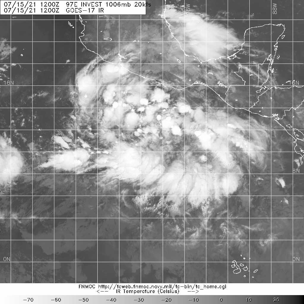
本帖最後由 老農民版夜神月 於 2021-7-18 03:36 編輯

NHC升格TS,並命名GUILLERMO
07E GUILLERMO 210717 1800 16.9N 109.5W EPAC 35 1004

20210717.1900.goes-17.vis.2km.07E.GUILLERMO.35kts.1004mb.16.9N.109.5W.pc.jpg 20210717.1530.gpm.89pct89h89v.07E.SEVEN.30kts.1007mb.16.5N.108.4W.055pc.jpg 20210717.1334.f17.91h.07E.SEVEN.30kts.1007mb.16.5N.108.4W.065pc.jpg
20211981800_GOES17-ABI-FL-GEOCOLOR-EP072021-1000x1000.jpg GOES19202021198kB7B4d.jpg
老農民版夜神月 發表於 2021-7-17 22:54
本帖最後由 老農民版夜神月 於 2021-7-18 03:29 編輯

NHC首報上望55KT
000
WTPZ42 KNHC 171440
TCDEP2

Tropical Depression Seven-E Discussion Number   1
NWS National Hurricane Center Miami FL       EP072021
900 AM MDT Sat Jul 17 2021

The broad low pressure system that the NHC has been monitoring for
the past few days well offshore the southwestern coast of Mexico
has finally developed enough organized deep convection and a
well-defined inner-core wind field to be classified as a tropical
depression. The initial intensity is estimated to be 30 kt, which is
a little below the consensus T2.5/35-kt classifications from TAFB
and SAB.

The initial motion estimate is an uncertain 295/15 kt due to the
lack of a well-defined center prior to 1200 UTC. Regardless, the
global and regional models are in exceptionally good agreement on
the cyclone moving west-northwestward today, and then turning toward
the west by late tonight or early Sunday, with that general motion
continuing through 72 hours. Thereafter, the deep-layer subtropical
ridge to the north that will steer the system for the next 5 days is
expected to build slightly southward, nudging the cyclone on a
west-southwestward track at 96 and 120 hours. The NHC forecast track
lies close to but a little slower than the various consensus models
out of respect for the slower GFS and GFS-ensemble models, which are
forecasting a stronger and, thus, more vertically deep tropical
cyclone that should move slower compared to the other weaker models.

During the next 48 hours or so, the cyclone is expected to remain
embedded within an environment conducive for strengthening,
characterized by light wind shear (<10 kt), sea-surface temperatures
(SST) above 27 deg C, and deep moisture through the low- to
mid-levels of the troposphere. Furthermore, a large upper-level low
located just west of the Baja California peninsula, which has been
enhancing the poleward outflows of this disturbance and Hurricane
Felicia farther to the west, is forecast to persist for at least the
next couple of days. All of these favorable conditions argue for at
least modest strengthening during that time, with the only hindering
factor being the large size of the system's circulation. Thereafter,
the cyclone will move over sub-26C SSTs, which should act to cap the
intensification process despite the low vertical wind shear
conditions that are expected to persist. However, the rate of
weakening is forecast to be a little slower than normal due to the
southern half of the circulation remaining over warmer waters, which
will provide warm moist inflow to help fuel thunderstorms near the
inner-core. The NHC intensity forecast closely follows the NOAA-HCCA
consensus model through 60 hours, and then is a little above all of
the consensus models thereafter.


FORECAST POSITIONS AND MAX WINDS

INIT  17/1500Z 16.8N 109.2W   30 KT  35 MPH
12H  18/0000Z 17.3N 110.8W   40 KT  45 MPH
24H  18/1200Z 17.9N 112.8W   45 KT  50 MPH
36H  19/0000Z 18.2N 115.1W   50 KT  60 MPH
48H  19/1200Z 18.3N 117.5W   55 KT  65 MPH
60H  20/0000Z 18.5N 120.0W   55 KT  65 MPH
72H  20/1200Z 18.5N 122.6W   50 KT  60 MPH
96H  21/1200Z 18.2N 127.7W   40 KT  45 MPH
120H  22/1200Z 17.9N 132.9W   35 KT  40 MPH

$$
Forecaster Stewart

144647_5day_cone_no_line_and_wind.png ep0721.gif 07E_171200sair.jpg

本平台僅供學術討論之用,預報應以氣象局為準

威普網站虛擬主機贊助公司

臺灣第一個天氣類型社群平台 即時天氣資訊、精準颱風動態

線上客服
FB傳送訊息
廣告行銷
精準行銷 物超所值
官方粉專
發佈 快速回復 返回頂部 返回列表