開啟輔助訪問
 找回密碼
 立即加入

07E.Guillermo 短暫發展

簽到天數: 483 天

[LV.9]以壇為家II

2021-7-15 20:35 來自手機 | 顯示全部樓層
  熱帶風暴  
編號:07 E
名稱:Guillermo
20210718.1230.goes-17.ir.07E.GUILLERMO.45kts.1000mb.17.8N.112W.100pc.jpg
  基本資料  
擾動編號日期:2021 07 15 20
命名日期  :2021 07 18 03
撤編日期  :2021 07 21 14
登陸地點  :


  巔峰時期資料  
近中心最強風速 :45  kt (
TS )
海平面最低氣壓 :1000 百帕

  擾動編號資料  

97E.INVEST.20kts.1006mb.10N.99W
2EAAD6E1-E8DF-42BA-BF9E-DA8546D37597.jpeg
NHC:40%
1. A large area of disorganized showers and thunderstorms continue well
offshore of the coast of southern Mexico in association with a
tropical wave.  Environmental conditions are expected to be
conducive for gradual development over the next several days, and a
tropical depression is likely to form this weekend well offshore of
the southwestern coast of Mexico while the system moves westward or
west-northwestward at around 15 mph.
* Formation chance through 48 hours...medium...40 percent.
* Formation chance through 5 days...high...90 percent.
AC5C45CE-8ADD-413E-982F-091BFF92A222.png
以上資料來自:NHC、颱風論壇整理製作

評分

參與人數 1水氣能量 +15 +1 收起 理由
周子堯@FB + 15 + 1

查看全部評分

回復

使用道具 舉報

簽到天數: 1650 天

[LV.Master]伴壇終老

老農民版夜神月|2021-7-16 10:00 | 顯示全部樓層
JTWC發布TCFA,NHC展望提升至60%/90%

ep9721.gif 97E_151900sair.jpg

two_pac_2d1 (3).png two_pac_5d1 (5).png
回復

使用道具 舉報

簽到天數: 483 天

[LV.9]以壇為家II

dom|2021-7-16 14:38 | 顯示全部樓層
NHC展望提升至High。
ZCZC MIATWOEP ALL
TTAA00 KNHC DDHHMM

Tropical Weather Outlook
NWS National Hurricane Center Miami FL
1100 PM PDT Thu Jul 15 2021

For the eastern North Pacific...east of 140 degrees west longitude:

The National Hurricane Center is issuing advisories on Hurricane
Felicia, located over 800 miles southwest of the southern tip of the
Baja California peninsula.

1. A broad area of low pressure located several hundred miles south of
the coast of southern Mexico is producing a large area of
disorganized showers and thunderstorms.  Environmental conditions
are expected to remain conducive for gradual development during the
next several days, and a tropical depression is likely to form this
weekend and move westward or west-northwestward at around 15 mph, a
few hundred miles offshore of the southwestern coast of Mexico.
* Formation chance through 48 hours...high..70 percent.
* Formation chance through 5 days...high...90 percent.

Forecaster Beven
143139cn5ynl9in5nxs559.png
回復

使用道具 舉報

簽到天數: 1650 天

[LV.Master]伴壇終老

老農民版夜神月|2021-7-17 22:54 | 顯示全部樓層
本帖最後由 老農民版夜神月 於 2021-7-18 03:29 編輯

NHC首報上望55KT
000
WTPZ42 KNHC 171440
TCDEP2

Tropical Depression Seven-E Discussion Number   1
NWS National Hurricane Center Miami FL       EP072021
900 AM MDT Sat Jul 17 2021

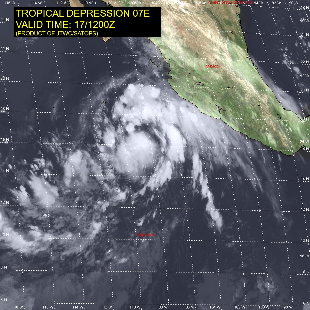
The broad low pressure system that the NHC has been monitoring for
the past few days well offshore the southwestern coast of Mexico
has finally developed enough organized deep convection and a
well-defined inner-core wind field to be classified as a tropical
depression. The initial intensity is estimated to be 30 kt, which is
a little below the consensus T2.5/35-kt classifications from TAFB
and SAB.

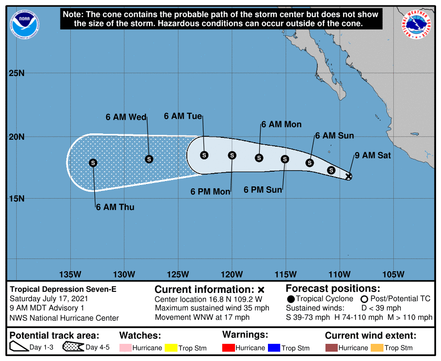
The initial motion estimate is an uncertain 295/15 kt due to the
lack of a well-defined center prior to 1200 UTC. Regardless, the
global and regional models are in exceptionally good agreement on
the cyclone moving west-northwestward today, and then turning toward
the west by late tonight or early Sunday, with that general motion
continuing through 72 hours. Thereafter, the deep-layer subtropical
ridge to the north that will steer the system for the next 5 days is
expected to build slightly southward, nudging the cyclone on a
west-southwestward track at 96 and 120 hours. The NHC forecast track
lies close to but a little slower than the various consensus models
out of respect for the slower GFS and GFS-ensemble models, which are
forecasting a stronger and, thus, more vertically deep tropical
cyclone that should move slower compared to the other weaker models.

During the next 48 hours or so, the cyclone is expected to remain
embedded within an environment conducive for strengthening,
characterized by light wind shear (<10 kt), sea-surface temperatures
(SST) above 27 deg C, and deep moisture through the low- to
mid-levels of the troposphere. Furthermore, a large upper-level low
located just west of the Baja California peninsula, which has been
enhancing the poleward outflows of this disturbance and Hurricane
Felicia farther to the west, is forecast to persist for at least the
next couple of days. All of these favorable conditions argue for at
least modest strengthening during that time, with the only hindering
factor being the large size of the system's circulation. Thereafter,
the cyclone will move over sub-26C SSTs, which should act to cap the
intensification process despite the low vertical wind shear
conditions that are expected to persist. However, the rate of
weakening is forecast to be a little slower than normal due to the
southern half of the circulation remaining over warmer waters, which
will provide warm moist inflow to help fuel thunderstorms near the
inner-core. The NHC intensity forecast closely follows the NOAA-HCCA
consensus model through 60 hours, and then is a little above all of
the consensus models thereafter.


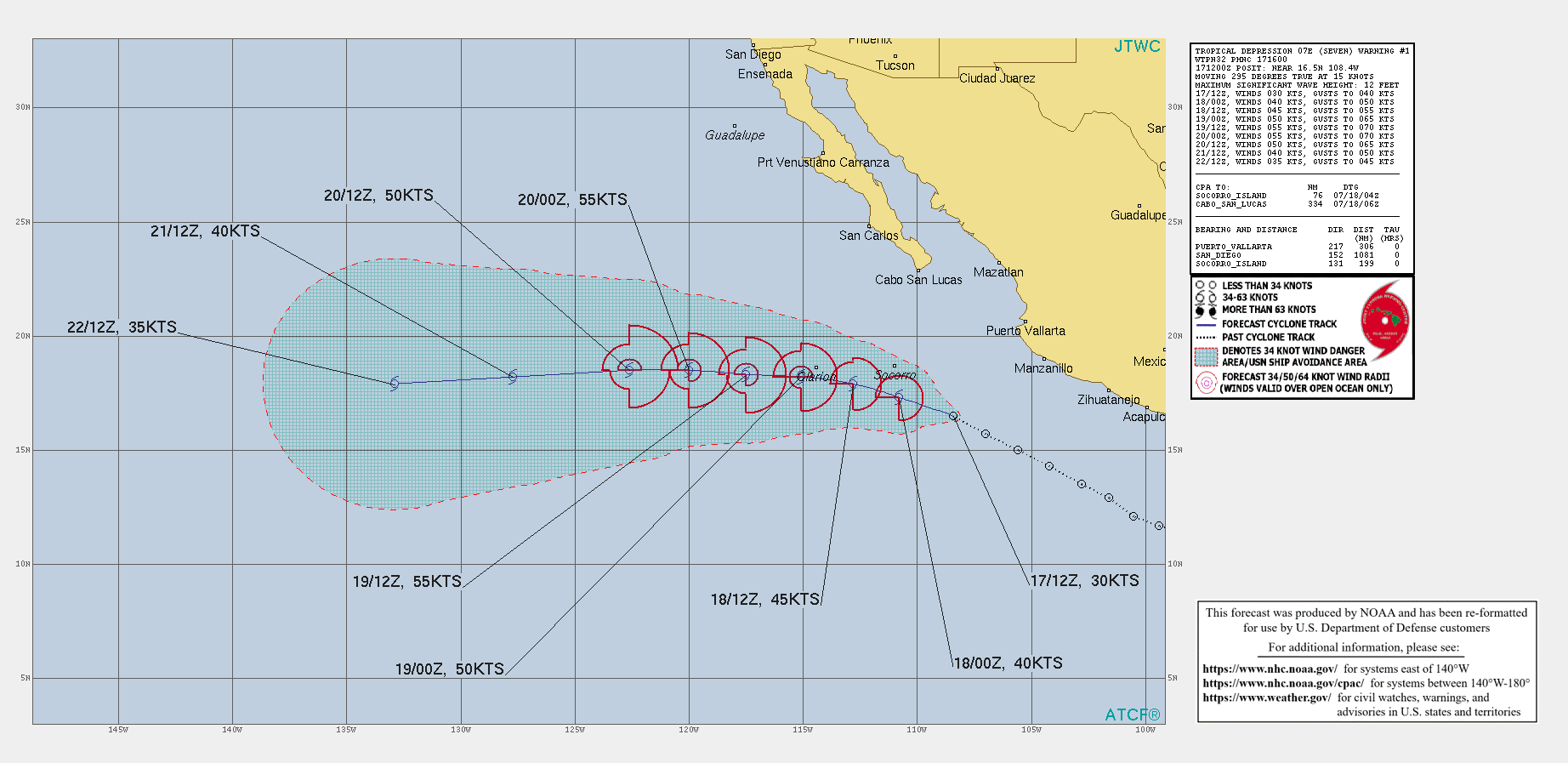
FORECAST POSITIONS AND MAX WINDS

INIT  17/1500Z 16.8N 109.2W   30 KT  35 MPH
12H  18/0000Z 17.3N 110.8W   40 KT  45 MPH
24H  18/1200Z 17.9N 112.8W   45 KT  50 MPH
36H  19/0000Z 18.2N 115.1W   50 KT  60 MPH
48H  19/1200Z 18.3N 117.5W   55 KT  65 MPH
60H  20/0000Z 18.5N 120.0W   55 KT  65 MPH
72H  20/1200Z 18.5N 122.6W   50 KT  60 MPH
96H  21/1200Z 18.2N 127.7W   40 KT  45 MPH
120H  22/1200Z 17.9N 132.9W   35 KT  40 MPH

$$
Forecaster Stewart
144647_5day_cone_no_line_and_wind.png ep0721.gif 07E_171200sair.jpg
回復

使用道具 舉報

簽到天數: 1650 天

[LV.Master]伴壇終老

老農民版夜神月|2021-7-18 03:29 | 顯示全部樓層
本帖最後由 老農民版夜神月 於 2021-7-18 03:36 編輯

NHC升格TS,並命名GUILLERMO
07E GUILLERMO 210717 1800 16.9N 109.5W EPAC 35 1004

20210717.1900.goes-17.vis.2km.07E.GUILLERMO.35kts.1004mb.16.9N.109.5W.pc.jpg 20210717.1530.gpm.89pct89h89v.07E.SEVEN.30kts.1007mb.16.5N.108.4W.055pc.jpg 20210717.1334.f17.91h.07E.SEVEN.30kts.1007mb.16.5N.108.4W.065pc.jpg
20211981800_GOES17-ABI-FL-GEOCOLOR-EP072021-1000x1000.jpg GOES19202021198kB7B4d.jpg
回復

使用道具 舉報

簽到天數: 483 天

[LV.9]以壇為家II

dom|2021-7-18 16:43 | 顯示全部樓層
NHC09Z調升定強至45節,預測24H後達到顛峰。
000
WTPZ42 KNHC 180835
TCDEP2

Tropical Storm Guillermo Discussion Number   4
NWS National Hurricane Center Miami FL       EP072021
300 AM MDT Sun Jul 18 2021

Guillermo has become a little better organized, with more deep
convection concentrated near the estimated center, and some banding
features trying to develop over the southern part of the
circulation.  Upper-level outflow is fairly well-defined over the
southern semicircle as well.  The latest Dvorak intensity estimates
from both TAFB and SAB are 45 kt, and this is used for the advisory
intensity.  Scatterometer data from ASCAT-A suggest that this may be
a somewhat generous intensity estimate, but the ASCAT-B and ASCAT-C
sensors did not sample the strongest part of the circulation.

There is still considerable scatter in the center fixes from
geostationary imagery.  Blending these fixes with additional center
positions from microwave imagery yields a slightly slower forward
motion of about 285/10 kt.  A mid-level ridge should be established
to the north of Guillermo for the next several days.  This is
likely to result in a generally westward track at a faster forward
speed through most of the forecast period.  Late in the period, a
slight bend toward the west-southwest is expected as the weakening
cyclone is influenced more by the low-level flow.  The official
track forecast is quite close to the previous one and is near, or a
little slower than, the latest multi-model consensus.

Some additional strengthening is anticipated while the system is in
a relatively low shear environment during the next day or so.  
However, the SHIPS model indicates some increase in northwesterly
shear in 1-2 days.  Thereafter, SSTs beneath Guillermo should
decrease.  These changes should lead to a leveling off of the
intensity, followed by gradual weakening. The NHC intensity forecast
is near or above the model consensus, IVCN, and is also very similar
to the latest HWRF model prediction.


FORECAST POSITIONS AND MAX WINDS

INIT  18/0900Z 17.6N 111.6W   45 KT  50 MPH
12H  18/1800Z 18.0N 113.1W   50 KT  60 MPH
24H  19/0600Z 18.4N 115.5W   55 KT  65 MPH
36H  19/1800Z 18.7N 118.2W   55 KT  65 MPH
48H  20/0600Z 18.7N 120.9W   50 KT  60 MPH
60H  20/1800Z 18.7N 123.8W   40 KT  45 MPH
72H  21/0600Z 18.5N 126.8W   35 KT  40 MPH
96H  22/0600Z 18.0N 132.0W   30 KT  35 MPH
120H  23/0600Z 17.5N 137.0W   30 KT  35 MPH

$$
Forecaster Pasch
083624_5day_cone_no_line_and_wind.png
回復

使用道具 舉報

簽到天數: 483 天

[LV.9]以壇為家II

dom|2021-7-19 11:01 | 顯示全部樓層
NHC03Z定強45節,並判定其已達到顛峰
000
WTPZ42 KNHC 190234
TCDEP2

Tropical Storm Guillermo Discussion Number   7
NWS National Hurricane Center Miami FL       EP072021
500 PM HST Sun Jul 18 2021

Guillermo's convective pattern has eroded significantly since the
previous advisory due to northwesterly vertical wind shear and
entrainment of drier and cooler air. Earlier ASCAT showed the system
was a solid 50-kt tropical cyclone, thus, only slight weakening is
indicated on this advisory to allow for some spin down of the
vortex. Deep convection will likely return near the center later
tonight during the nocturnal convective maximum period, especially
since the cyclone is still going to be moving over sea-surface
temperatures (SST) near 27 deg C, which should result in some slight
re-strengthening or at least hold a steady intensity for the next 24
h or so. By 36 h and beyond, however, Guillermo will be passing over
sub-25C SSTs and into a stronger northwesterly wind shear
environment, which should induce slow but steady weakening through
the rest of the forecast period, with the cyclone becoming a
post-tropical remnant low by 120 hours. The new NHC intensity
forecast is similar to the previous advisory and closely follows the
NOAA-HCCA and IVCN consensus models.

The initial motion estimate is now westward, or 280/13 kt. Guillermo
made a due west lurch at about 18 kt after the central deep
convection dissipated, which resulted in the vortex becoming a
little more vertically shallow. However, the motion over the past
few hours has been fairly steady at around 13 kt. The latest model
guidance is tightly packed about the previous advisory track, so
no significant changes were required since the global and regional
models maintain the strong subtropical ridge to the north of
Guillermo for the next 120 hours. The official forecast track
closely follows a blend of the TVCE and GFEX simple consensus
models, and the HCCA corrected-consensus model.


FORECAST POSITIONS AND MAX WINDS

INIT  19/0300Z 18.9N 115.6W   45 KT  50 MPH
12H  19/1200Z 19.1N 117.6W   45 KT  50 MPH
24H  20/0000Z 19.2N 120.4W   45 KT  50 MPH
36H  20/1200Z 19.1N 123.2W   40 KT  45 MPH
48H  21/0000Z 19.1N 126.1W   35 KT  40 MPH
60H  21/1200Z 18.9N 128.9W   30 KT  35 MPH
72H  22/0000Z 18.6N 131.6W   30 KT  35 MPH
96H  23/0000Z 18.3N 136.7W   25 KT  30 MPH
120H  24/0000Z 18.3N 141.7W   20 KT  25 MPH...POST-TROP/REMNT LOW

$$
Forecaster Stewart
023531_5day_cone_no_line_and_wind.png
回復

使用道具 舉報

簽到天數: 1650 天

[LV.Master]伴壇終老

老農民版夜神月|2021-7-20 09:43 | 顯示全部樓層
NHC18Z降格TD
000
WTPZ42 KNHC 192038
TCDEP2

Tropical Depression Guillermo Discussion Number  10
NWS National Hurricane Center Miami FL       EP072021
200 PM PDT Mon Jul 19 2021

Guillermo is now producing a small shapeless area of convection
about 70 miles to the southeast of the center, but otherwise, the
cyclone consists mainly of a swirl of low clouds.  A recent METOP-A
scatterometer pass showed an area 25-30 kt winds well north (about
90 miles) of the center.  Based on this data, the initial intensity
is lowered to 30 kt.  With the combined negative contributions of
cool sub 25C oceanic temperatures, stiff west-northwesterly shear
and entrainment of high statically stable marine-layer air,
Guillermo should degenerate to a remnant low by Wednesday night, if
not sooner.  The large-scale models and the statistical intensity
guidance show the cyclone opening up into a trough of low pressure
by day 4, and the NHC forecast follows suit.

The depression has increased in forward speed to 15 kt, while moving
westward in the fresh tradewind steering flow.  A continued westward
motion on the south side of a low- to mid-level subtropical ridge at
about the same aforementioned speed is forecast during the entire
period.  The official track forecast is close to the middle of the
model guidance envelope and a little to the left of the previous
advisory.


FORECAST POSITIONS AND MAX WINDS

INIT  19/2100Z 19.3N 119.8W   30 KT  35 MPH
12H  20/0600Z 19.2N 122.3W   30 KT  35 MPH
24H  20/1800Z 18.8N 125.4W   30 KT  35 MPH
36H  21/0600Z 18.4N 128.4W   25 KT  30 MPH...POST-TROP/REMNT LOW
48H  21/1800Z 18.1N 131.4W   25 KT  30 MPH...POST-TROP/REMNT LOW
60H  22/0600Z 17.8N 133.8W   25 KT  30 MPH...POST-TROP/REMNT LOW
72H  22/1800Z 17.6N 136.4W   20 KT  25 MPH...POST-TROP/REMNT LOW
96H  23/1800Z...DISSIPATED

$$
Forecaster Roberts
204148_5day_cone_no_line_and_wind.png 07E_191800sair.jpg
回復

使用道具 舉報

12下一頁
快速回覆
您需要登錄後才可以回帖 登錄 | 立即加入

本版積分規則

本平台僅供學術討論之用,預報應以氣象局為準

威普網站虛擬主機贊助公司

臺灣第一個天氣類型社群平台 即時天氣資訊、精準颱風動態

線上客服
FB傳送訊息
廣告行銷
精準行銷 物超所值
官方粉專
發佈 快速回復 返回頂部 返回列表