開啟輔助訪問
 找回密碼
 立即加入

09L.Hermine 巔峰登陸 11年來首個登陸佛州颶風 轉化後熱帶氣旋

簽到天數: 474 天

[LV.9]以壇為家II

2016-8-19 10:34 | 顯示全部樓層
提示: 作者被禁止或刪除 內容自動屏蔽
回復

使用道具 舉報

簽到天數: 474 天

[LV.9]以壇為家II

劉瑞益@FB|2016-8-23 10:42 | 顯示全部樓層
提示: 作者被禁止或刪除 內容自動屏蔽
回復

使用道具 舉報

簽到天數: 3279 天

[LV.Master]伴壇終老

t02436|2016-8-24 13:50 | 顯示全部樓層
美國海軍已經在昨天14Z發布TCFA
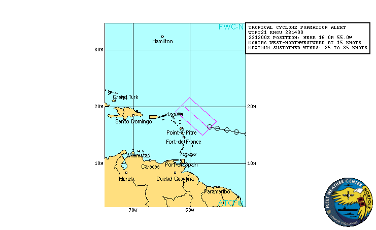
al992016.20160824040927.gif

NHC維持2日展望在50%,飛機實測有望在稍晚啟動。
1. Satellite images, surface observations, and radar data from the
Lesser Antilles indicate that a broad area of low pressure
associated with a tropical wave is located near Guadeloupe.
Although environmental conditions are only marginally conducive for
development, this system could become a tropical depression during
the next day or two while it moves west-northwest at 15 to 20 mph
across the Leeward Islands and the Greater Antilles.  Conditions
could become more conducive later this week while the system moves
near the southeastern and central Bahamas.  An Air Force Reserve
Hurricane Hunter aircraft is scheduled to investigate this
disturbance later today, if necessary.
  Interests from the islands
of the northeastern Caribbean Sea to the Bahamas should continue to
monitor the progress of this system.  Gusty winds, heavy rains, and
possible flash floods and mudslides could occur over portions of
these areas regardless of tropical cyclone formation. Please consult
products issued by your local meteorological offices for further
details.
* Formation chance through 48 hours...medium...50 percent
* Formation chance through 5 days...high...70 percent
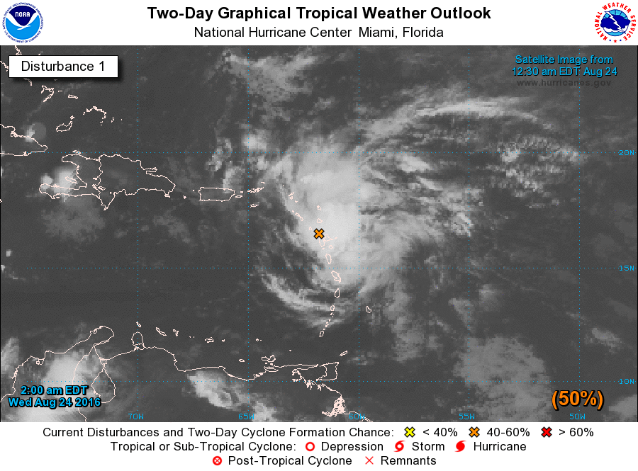
two_atl_2d1.png

I.  ATLANTIC REQUIREMENTS
    1. SUSPECT AREA
       FLIGHT ONE - TEAL 70           
       A. 24/2330Z,25/0530Z
       B. AFXXX 0408A CYCLONE
       C. 24/2230Z
       D. 19.7N 66.4W
       E. 24/2300Z TO 25/0530Z
       F. SFC TO 10,000

       FLIGHT TWO - TEAL 71
       A. 25/1130Z,1730Z
       B. AFXXX 0508A CYCLONE
       C. 25/1000Z
       D. 21.2N 69.1W
       E. 25/1100Z TO 25/1730Z
       F. SFC TO 15,000 FT
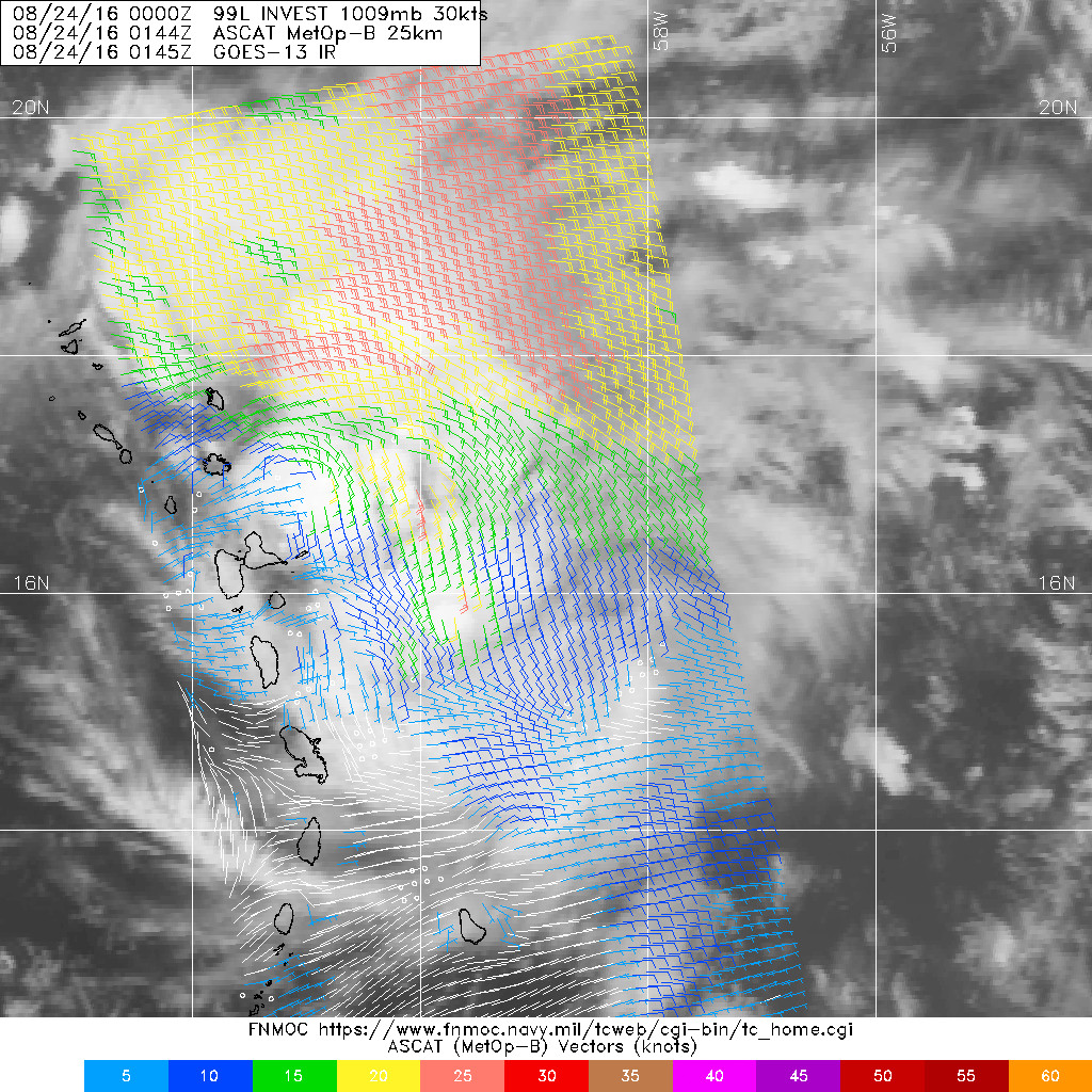
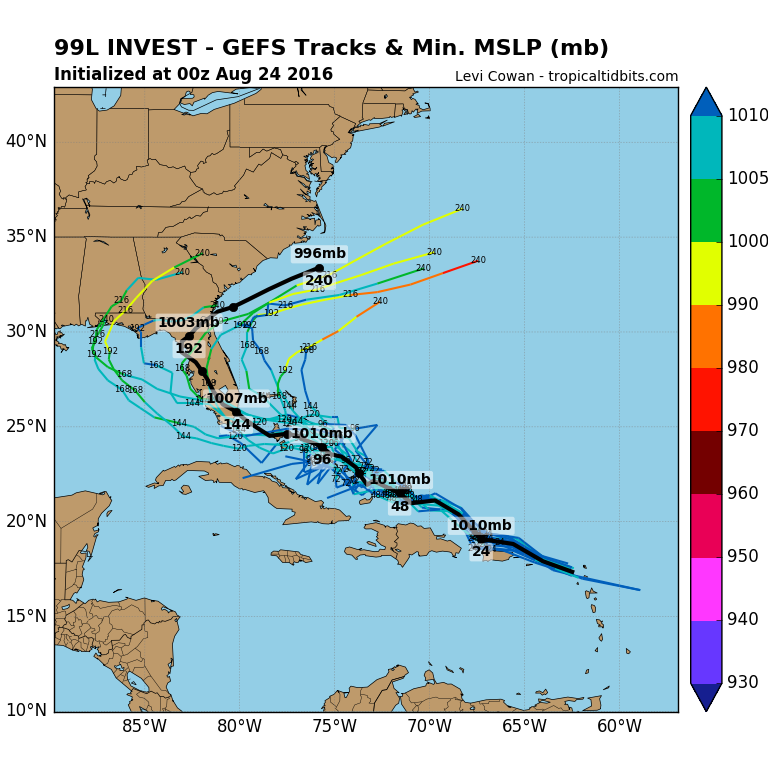
20160824.0144.mtb.ASCAT.wind.99L.INVEST.30kts-1009mb.164N.589W.25km.jpg

99L_gefs_latest.png

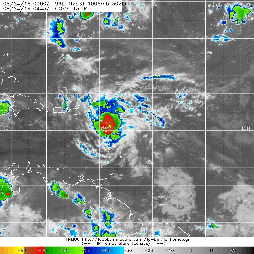
20160824.0445.goes-13.ircolor.99L.INVEST.30kts.1009mb.16.4N.58.9W.100pc.jpg
回復

使用道具 舉報

簽到天數: 3279 天

[LV.Master]伴壇終老

t02436|2016-8-25 01:04 | 顯示全部樓層
第一次飛機實測進行中,目前測得10秒平均飛行層面及SFMR海平面風速均超過45節
145830 1830N 06319W 9884 00201 0116 +222 +172 140043 045 045 000 03
145900 1830N 06318W 9879 00207 0117 +220 +171 141044 045 045 000 03
145930 1830N 06316W 9881 00205 0117 +219 +170 142046 049 045 000 03
150000 1830N 06315W 9884 00202 0117 +221 +167 142046 049 044 000 03
150030 1830N 06314W 9884 00203 0119 +220 +168 144046 047 045 000 03
150100 1830N 06312W 9883 00206 0119 +220 +164 146047 048 046 001 03
150130 1830N 06311W 9884 00206 0121 +220 +167 150045 046 045 000 00
150200 1830N 06309W 9880 00208 0122 +220 +167 150044 046 043 000 03
150230 1830N 06308W 9889 00203 0124 +222 +166 148045 048 044 000 03
150300 1830N 06307W 9875 00217 0125 +224 +164 150045 046 045 000 03
150330 1830N 06305W 9891 00207 0126 +223 +165 152045 046 040 002 03
150400 1829N 06304W 9881 00214 0126 +220 +163 156044 047 /// /// 03
150430 1828N 06304W 9882 00211 0125 +218 +160 157043 044 /// /// 03
150500 1827N 06303W 9889 00206 0126 +218 +161 157043 045 047 001 03
150530 1827N 06302W 9887 00208 0126 +220 +157 159043 046 044 000 03
150600 1826N 06301W 9895 00207 0128 +219 +159 159043 044 045 000 03

recon_AF308-O2EEA-INVEST_timeseries.png

recon_AF308-O2EEA-INVEST.png

以穿心第一次測得之風力,加上NHC 12Z已經評價30節,18Z報會升格08L並有望直接命名Hermine。
99L INVEST 160824 1200  17.7N   63.2W ATL   30  1009

rbtop-animated.gif

點評

第一次飛機實測的第二次穿心飛行進行中,風速突破50節大關,NHC應該要準備發Special Advisory了。 [attachimg]64601[/attachimg] [attachimg]64602[/attachimg] [attachimg]64600[/attachimg]  詳情 回復 發表於 2016-8-25 01:31
回復

使用道具 舉報

簽到天數: 3279 天

[LV.Master]伴壇終老

t02436|2016-8-25 01:31 | 顯示全部樓層
t02436 發表於 2016-8-25 01:04
第一次飛機實測進行中,目前測得10秒平均飛行層面及SFMR海平面風速均超過45節

第一次飛機實測的第二次穿心飛行進行中,風速突破50節大關,NHC應該要準備發Special Advisory了。
170500 1850N 06359W 9900 00171 0098 +216 +177 153045 047 046 001 00
170530 1849N 06359W 9912 00161 0096 +216 +176 156052 055 053 000 03
170600 1848N 06359W 9906 00162 0096 +214 +173 158055 056 052 001 03
170630 1847N 06358W 9898 00168 0095 +214 +174 159052 055 050 002 03
170700 1846N 06359W 9909 00165 0097 +214 +177 158052 054 053 001 03
170730 1845N 06359W 9901 00172 0100 +211 +177 155052 054 052 000 00
170800 1844N 06359W 9903 00175 0103 +210 +178 152051 051 048 000 03
170830 1843N 06400W 9907 00168 0102 +213 +182 152050 052 050 001 00
170900 1842N 06400W 9906 00169 0103 +216 +183 155053 056 046 000 03
170930 1841N 06401W 9901 00174 0101 +213 +182 154051 053 049 000 00
171000 1839N 06401W 9912 00166 0099 +234 +189 163041 049 050 002 00
171030 1838N 06402W 9908 00169 0102 +236 +192 163029 032 039 002 03
171100 1837N 06402W 9914 00165 0105 +221 +185 166043 045 046 001 00

recon_AF308-O2EEA-INVEST.png

recon_AF308-O2EEA-INVEST_timeseries.png

20160824.1645.goes-13.vis.1km.99L.INVEST.30kts.1009mb.16.7N.61.3W.100pc.jpg

點評

結果最後判定中心沒有閉合圈,持續維持50%...  發表於 2016-8-25 10:31
回復

使用道具 舉報

簽到天數: 474 天

[LV.9]以壇為家II

劉瑞益@FB|2016-8-29 08:08 | 顯示全部樓層
提示: 作者被禁止或刪除 內容自動屏蔽
回復

使用道具 舉報

簽到天數: 474 天

[LV.9]以壇為家II

劉瑞益@FB|2016-9-1 09:41 | 顯示全部樓層
提示: 作者被禁止或刪除 內容自動屏蔽
回復

使用道具 舉報

簽到天數: 3279 天

[LV.Master]伴壇終老

t02436|2016-9-2 01:54 | 顯示全部樓層
〝第13次〞飛機實測進行中....
recon_AF307-1309A-HERMINE.png

recon_AF307-1309A-HERMINE_timeseries.png

稍早NHC根據實測結果於17Z發出第17報正報
ZCZC MIATCUAT4 ALL
TTAA00 KNHC DDHHMM

TROPICAL STORM HERMINE TROPICAL CYCLONE UPDATE
NWS NATIONAL HURRICANE CENTER MIAMI FL       AL092016
1155 AM CDT THU SEP 01 2016

...TROPICAL STORM WARNING EXTENDED SOUTHWARD ALONG THE GULF AND
EAST COASTS OF FLORIDA...

Data from an Air Force Reserve Hurricane Hunter aircraft indicate
that tropical-storm-force winds extend significantly farther to the
east of the center of Hermine than they did earlier.  This requires
the extension of the Tropical Storm Warning southward along the Gulf
coast of Florida to Englewood, and along the Florida east coast
southward to the Flagler/Volusia County line.

A special advisory will be issued within the next 30 minutes to
update the forecast and warnings for Hermine.

$$
Forecaster Brennan/Pasch


NNNN

評價上升到60節,預測00Z上C1,24小時之內登陸。
TROPICAL STORM CENTER LOCATED NEAR 27.8N  85.6W AT 01/1700Z
POSITION ACCURATE WITHIN  20 NM

PRESENT MOVEMENT TOWARD THE NORTH-NORTHEAST OR  30 DEGREES AT  12 KT

ESTIMATED MINIMUM CENTRAL PRESSURE  989 MB
MAX SUSTAINED WINDS  60 KT WITH GUSTS TO  75 KT.
50 KT.......100NE 120SE  30SW  30NW.
34 KT.......150NE 160SE  60SW  60NW.
12 FT SEAS..120NE 120SE  30SW   0NW.
WINDS AND SEAS VARY GREATLY IN EACH QUADRANT.  RADII IN NAUTICAL
MILES ARE THE LARGEST RADII EXPECTED ANYWHERE IN THAT QUADRANT.

REPEAT...CENTER LOCATED NEAR 27.8N  85.6W AT 01/1700Z
AT 01/1200Z CENTER WAS LOCATED NEAR 27.0N  86.2W

FORECAST POSITIONS AND MAX WINDS

INIT  01/1700Z 27.8N  85.6W   60 KT  70 MPH
12H  02/0000Z 29.0N  84.8W   65 KT  75 MPH
24H  02/1200Z 31.1N  82.9W   50 KT  60 MPH...INLAND
36H  03/0000Z 33.1N  80.0W   45 KT  50 MPH...INLAND
48H  03/1200Z 35.2N  76.7W   40 KT  45 MPH...POST-TROP/EXTRATROP
72H  04/1200Z 38.0N  72.5W   45 KT  50 MPH...POST-TROP/EXTRATROP
96H  05/1200Z 38.5N  71.5W   45 KT  50 MPH...POST-TROP/EXTRATROP
120H  06/1200Z 39.5N  70.5W   45 KT  50 MPH...POST-TROP/EXTRATROP

153730W5_NL_sm.gif

風眼看來要被捲出來了
20160901.1220.f18.91pct91h91v.09L.HERMINE.55kts.992mb.27N.86.2W.050pc.jpg

vis-animated.gif

20160901.1715.goes-13.ircolor.09L.HERMINE.55kts.992mb.27N.86.2W.100pc.jpg

國家颶風中心局長Rick Knabb也罕見的將在稍後於Twitter對Hermine進行直播。
NHC director Rick Knabb will provide a live update on Hermine at 2:30pm EDT. Watch it live here or on Twitter.

結論:有富爸爸真好:L
回復

使用道具 舉報

12下一頁
快速回覆
您需要登錄後才可以回帖 登錄 | 立即加入

本版積分規則

本平台僅供學術討論之用,預報應以氣象局為準

威普網站虛擬主機贊助公司

臺灣第一個天氣類型社群平台 即時天氣資訊、精準颱風動態

線上客服
FB傳送訊息
廣告行銷
精準行銷 物超所值
官方粉專
發佈 快速回復 返回頂部 返回列表