開啟輔助訪問
 找回密碼
 立即加入

14E.Madeline 接近夏威夷前快速增強上C4 擦過夏威夷南方近海

簽到天數: 474 天

[LV.9]以壇為家II

2016-8-22 23:12 | 顯示全部樓層
提示: 作者被禁止或刪除 內容自動屏蔽
回復

使用道具 舉報

簽到天數: 3279 天

[LV.Master]伴壇終老

t02436|2016-8-25 10:35 | 顯示全部樓層
NHC:40%
1. Showers and thunderstorms associated with an area of low pressure
located about 1300 miles southwest of the southern tip of the Baja
California peninsula continue to show some signs of organization.
Environmental conditions are expected to be conducive for slow
development of this system, and a tropical depression is likely to
form by this weekend while the low moves westward or west-
northwestward at about 15 mph.
* Formation chance through 48 hours...medium...40 percent
* Formation chance through 5 days...high...80 percent

two_pac_2d1.png

98E_gefs_latest.png

20160825.0200.goes-15.ircolor.98E.INVEST.25kts.1008mb.12N.125W.100pc.jpg

回復

使用道具 舉報

簽到天數: 474 天

[LV.9]以壇為家II

劉瑞益@FB|2016-8-27 07:39 | 顯示全部樓層
提示: 作者被禁止或刪除 內容自動屏蔽
回復

使用道具 舉報

簽到天數: 474 天

[LV.9]以壇為家II

劉瑞益@FB|2016-8-27 10:55 | 顯示全部樓層
提示: 作者被禁止或刪除 內容自動屏蔽
回復

使用道具 舉報

簽到天數: 474 天

[LV.9]以壇為家II

劉瑞益@FB|2016-8-28 12:54 | 顯示全部樓層
提示: 作者被禁止或刪除 內容自動屏蔽
回復

使用道具 舉報

簽到天數: 3279 天

[LV.Master]伴壇終老

t02436|2016-8-29 23:39 | 顯示全部樓層
底層差不多了,等待高層清空中
CPHC 15Z給85Kts,站上C2
WTPA45 PHFO 291442
TCDCP5

HURRICANE MADELINE DISCUSSION NUMBER  12
NWS CENTRAL PACIFIC HURRICANE CENTER HONOLULU HI   EP142016
500 AM HST MON AUG 29 2016

Madeline's cloud-covered eye re-emerged by 1200 UTC with a
cooler-topped and increasingly well-formed eyewall. Organization
continues to improve, with little or no shear deformation present.
Subjective Dvorak satellite intensity estimates range from 5.0/90
kt from SAB and PHFO to 4.5/77 kt from JTWC, while UW-CIMSS provided
an estimated intensity of 81 kt. We will compromise and assign
Madeline an initial intensity of 85 kt for this advisory cycle,
representing continued rapid intensification of this system.


The steering mechanism for Madeline has not changed since last
evening. An upper trough northwest of the main Hawaiian Islands
continues to allow Madeline to gain latitude as this system tracks
along the southern flank of the subtropical ridge. Global models
show this upper trough will lift northward through 72 hours,
gradually allowing the ridge to steer Madeline along a more westerly
to west-southwesterly track. This appears to be happening already,
with 6 hour motion noticeably to the left of the west-northwest 12
hour motion. By 72 hours, the upper trough is forecast to dig
southward again, prompting most track guidance toward westerly
to west-northwesterly motion again on days 4 and 5. Track guidance
remains tightly packed through 72 hours, depicting a shallow S-curve
westward then west southwestward through 72 hours, followed by the
gradual turn westward to west northwestward afterwards. The forecast
track follows the previous one closely, but was altered slightly
south at 72 hours, then slightly north at 96 and 120 hours to more
closely follow consensus guidance.

While SHIPS probability for rapid intensification remains over 30
percent through 24 hours, most intensity guidance shows more modest
strengthening by day 2.
We cap Madeline at 90 kt at 12 and 24 hours,
then introduce gradual weakening through day 5 as shear increases.
Our intensity forecast closely follows IVCN consensus through day 2,
then depicts a weakening rate similar to that shown by LGEM
afterwards.

The forecast track depicts Madeline passing just south of
the Big Island of Hawaii as a hurricane on day 3. Average day 3
forecast track error is around 130 miles, so this would be a good
time to remind users to consider the error cone associated with each
forecast and not just the black line depicting the forecast track of
the system center. Also, tropical systems can be quite large and may
affect areas far from the system center.

FORECAST POSITIONS AND MAX WINDS

INIT  29/1500Z 18.2N 144.6W   85 KT 100 MPH
12H  30/0000Z 18.6N 146.0W   90 KT 105 MPH
24H  30/1200Z 19.0N 147.7W   90 KT 105 MPH
36H  31/0000Z 19.0N 149.6W   85 KT 100 MPH
48H  31/1200Z 18.9N 151.7W   80 KT  90 MPH
72H  01/1200Z 18.1N 155.9W   70 KT  80 MPH
96H  02/1200Z 17.7N 160.2W   60 KT  70 MPH
120H  03/1200Z 17.6N 164.5W   55 KT  65 MPH

$$
Forecaster Powell

probEP142016_160829_1430_sata1.gif

20160829.1334.f16.91pct91h91v.14E.MADELINE.85kts.975mb.18N.144.2W.080pc.jpg

rbtop-animated.gif


2016EP14_OHCNFCST_201608291200.GIF
回復

使用道具 舉報

簽到天數: 582 天

[LV.9]以壇為家II

蜜露|2016-8-30 21:05 | 顯示全部樓層
本帖最後由 蜜露 於 2016-8-30 21:06 編輯


兩個Cat.4 等級的颶風共存 , 也是很難得一見的景像.
而且他們型態巔峰 ,時間還不到3小時. 有點類似1997年艾文 、瓊恩的小型版.
CrDuS_ZWEAEg5Rq.jpg


雖然沒有去年的奇羅 、伊格奧 、希梅娜 那種奇觀.  可是瑪德琳、雷斯特的型態巔峰時間相近.

而正好這兩個巔峰是屬於中太平洋和東太平洋之間。 好像瑪德琳屬中太,然後雷斯特是東太。

上次東太平洋兩股颶風Cat.4 型態相近+並排一起的是1993年的肯尼斯、利迪婭兩股強度更接近Cat.5 .比2016的還強
bandicam 2016-08-30 21-03-37-470.jpg


回復

使用道具 舉報

簽到天數: 3279 天

[LV.Master]伴壇終老

t02436|2016-8-31 11:15 | 顯示全部樓層
飛機實測已經啟動,目前CPHC預測Madeline將朝西南方向移動,待明天通過夏威夷大島南方後才轉往偏西進行,夏威夷可以說是逃過一次正面襲擊...
另外,到173W時還有55Kts,之後可以觀察看能不能活著進入西太
WTPA45 PHFO 310251
TCDCP5

HURRICANE MADELINE DISCUSSION NUMBER  18
NWS CENTRAL PACIFIC HURRICANE CENTER HONOLULU HI   EP142016
500 PM HST TUE AUG 30 2016

Under the presence of continued vertical wind shear, the satellite
presentation of Madeline has continued to gradually degrade today,
as an eye is no longer present. While Dvorak final T numbers
continue to drop, current intensity estimates range from 5.5/102 kt
at HFO to 5.0/90 kt out of JTWC and SAB, and CIMSS ADT has fallen
below 80 kt. Since Air Force reconnaissance aircraft reported
stronger than expected winds earlier in the day, the current
intensity will be set at 95 kt for this advisory. The Air Force
reconnaissance aircraft will fly another mission in Madeline this
evening.


The initial motion for this advisory remains due west at 270/09 kt.
Madeline continues to move westward along the southern edge of a low
to mid level ridge, while a shallow upper level trough continues to
dig toward the hurricane from the northwest. The ridge will keep
Madeline on a westward-moving track into the evening, followed by a
gradual turn toward the west-southwest tonight and Wednesday as the
mid level ridge strengthens to the north and northwest and the upper
level trough imparts northwesterly winds in the high levels of the
cyclone. This track will take the center of Madeline dangerously
close to the Big Island of Hawaii (Hawaii County) late Wednesday
into Thursday, and a Hurricane Warning remains in place for the Big
Island, given the very close approach of Madeline and uncertainty in
the track forecast. On Friday Madeline is forecast to turn back
toward the west as the upper level trough digs southward over
Hawaii. The official forecast track has changed little from the
prior advisory and is near TVCN, which lies in the middle of a
rather tightly clustered reliable guidance envelope during the next
three days. The guidance envelope spreads beyond day three, while
the GFDL remains the northern outlier through the entire forecast
duration.

Madeline is expected to gradually weaken through the next four days
as the upper level trough digs southward and continues to impart
vertical wind shear. UW CIMSS estimates current vertical wind shear
from the west-southwest at 14 kt, and SHIPS forecasts shear to
gradually increase during the next 24 to 36 hours before relaxing
on Friday. The official intensity forecast calls for gradual
weakening during this time that follows the trends of SHIPS and
IVCN, though at a slightly slower rate of weakening than the
guidance through Friday. Although it will be weakening, Madeline is
expected to remain a dangerous hurricane as it passes near the Big
Island of Hawaii late Wednesday into early Thursday.

We would like to remind everyone that hazards associated with
hurricanes can extend well away from the center, and you should
not focus too closely on the exact forecast track, as small changes
can lead to differences in impacts.


FORECAST POSITIONS AND MAX WINDS

INIT  31/0300Z 19.3N 150.3W   95 KT 110 MPH
12H  31/1200Z 19.1N 151.8W   85 KT 100 MPH
24H  01/0000Z 18.7N 153.8W   80 KT  90 MPH
36H  01/1200Z 18.3N 155.7W   70 KT  80 MPH
48H  02/0000Z 18.1N 157.8W   65 KT  75 MPH
72H  03/0000Z 18.2N 162.7W   60 KT  70 MPH
96H  04/0000Z 18.7N 168.2W   55 KT  65 MPH
120H  05/0000Z 19.0N 173.2W   55 KT  65 MPH

$$
Forecaster Wroe
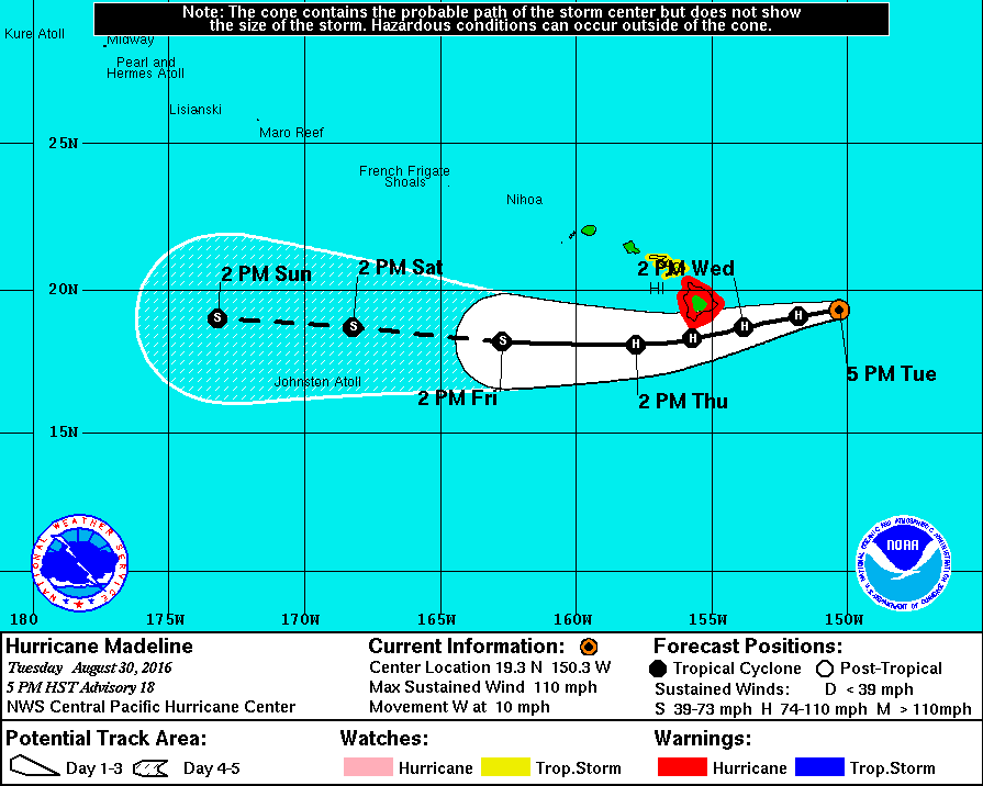
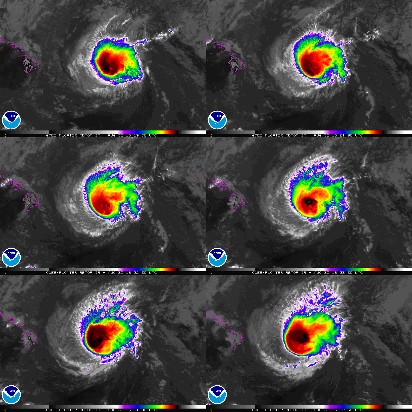
EP142016W.gif

rbtop-animated.gif
回復

使用道具 舉報

12下一頁
快速回覆
您需要登錄後才可以回帖 登錄 | 立即加入

本版積分規則

劉瑞益@FB

    主題

    帖子

    104萬

    積分

    13級[一級颶風]

    Rank: 13Rank: 13Rank: 13Rank: 13

13級[一級颶風]

發訊息

本平台僅供學術討論之用,預報應以氣象局為準

威普網站虛擬主機贊助公司

臺灣第一個天氣類型社群平台 即時天氣資訊、精準颱風動態

線上客服
FB傳送訊息
廣告行銷
精準行銷 物超所值
官方粉專
發佈 快速回復 返回頂部 返回列表