開啟輔助訪問
 找回密碼
 立即加入

16E.Orlene 發展超乎預期 貼北緯20度西行漸減弱

簽到天數: 474 天

[LV.9]以壇為家II

2016-9-9 07:45 | 顯示全部樓層
提示: 作者被禁止或刪除 內容自動屏蔽
回復

使用道具 舉報

簽到天數: 474 天

[LV.9]以壇為家II

劉瑞益@FB|2016-9-9 14:33 | 顯示全部樓層
提示: 作者被禁止或刪除 內容自動屏蔽
回復

使用道具 舉報

簽到天數: 474 天

[LV.9]以壇為家II

劉瑞益@FB|2016-9-10 08:01 | 顯示全部樓層
提示: 作者被禁止或刪除 內容自動屏蔽
回復

使用道具 舉報

簽到天數: 3279 天

[LV.Master]伴壇終老

t02436|2016-9-10 13:36 | 顯示全部樓層
美軍已發布TCFA
ep922016.20160910052141.gif

數值預測將在北緯20度穩定西行
92E_gefs_latest.png

92E_intensity_latest.png

rbtop-animated.gif
回復

使用道具 舉報

簽到天數: 3279 天

[LV.Master]伴壇終老

t02436|2016-9-11 10:55 | 顯示全部樓層
NHC升格16E,上望一級颶風。
000
WTPZ41 KNHC 110234
TCDEP1

TROPICAL DEPRESSION SIXTEEN-E DISCUSSION NUMBER   1
NWS NATIONAL HURRICANE CENTER MIAMI FL       EP162016
900 PM MDT SAT SEP 10 2016

The area of low pressure southwest of Mexico has become better
organized during the last several hours.  Earlier ASCAT data
indicated that the low had a well-defined center, and the latest
infrared images show enough organized deep convection in a band in
the northwestern quadrant declare this system a tropical depression.
The initial wind speed is set to 30 kt in accordance with the TAFB
satellite estimate.  This is the earliest 16th tropical cyclone
formation in the eastern Pacific since 1992.

The depression is forecast to be in an environment of light shear,
warm waters and a humid mid-level atmosphere for at least a few
days.  There are no obvious reasons why this cyclone would not
intensify, other than a somewhat broad initial wind structure, and
guidance is in fairly good agreement on at least gradual
strengthening for the next few days. The NHC intensity forecast is
near or slightly above the intensity guidance after 24 hours, and
this forecast could turn out to be conservative, especially in a few
days, if the system develops an inner core.  The long range
intensity is leveled off due to the uncertainty of what latitude the
cyclone will be located at after day 3, which is pretty critical in
that portion of the eastern Pacific due to the tight SST gradient.

An uncertain estimate of initial motion is 310/10.  The depression
is likely to move generally northwestward for the next couple of
days around a mid-level ridge centered over Mexico.  A weakness in
the ridge near 120-125 degrees west should cause the cyclone to turn
north-northwestward and decelerate as it enters weaker steering
currents near the ridge axis.  The weakness is forecast to fill in
by all the models on days 4 and 5, and this restrengthened ridge
would steer the cyclone generally westward at a faster forward speed
near the end of the forecast period.  Overall, the models agree on
the synoptic scenario, albeit with some timing disagreements.  The
NHC forecast track is close to the model consensus, which has been
an excellent guidance tool to smooth through the along and cross
track model differences so far in the 2016 eastern Pacific season.


FORECAST POSITIONS AND MAX WINDS

INIT  11/0300Z 13.9N 114.9W   30 KT  35 MPH
12H  11/1200Z 14.9N 116.3W   35 KT  40 MPH
24H  12/0000Z 16.0N 118.2W   45 KT  50 MPH
36H  12/1200Z 16.9N 119.6W   55 KT  65 MPH
48H  13/0000Z 17.7N 120.3W   65 KT  75 MPH
72H  14/0000Z 18.9N 120.7W   70 KT  80 MPH
96H  15/0000Z 19.1N 122.5W   65 KT  75 MPH
120H  16/0000Z 19.0N 126.0W   65 KT  75 MPH

$$
Forecaster Blake

023225W_sm.gif

rbtop-animated.gif
回復

使用道具 舉報

簽到天數: 3279 天

[LV.Master]伴壇終老

t02436|2016-9-11 16:38 | 顯示全部樓層
命名報
ZCZC MIATCDEP1 ALL
TTAA00 KNHC DDHHMM

TROPICAL STORM ORLENE DISCUSSION NUMBER   2
NWS NATIONAL HURRICANE CENTER MIAMI FL       EP162016
200 AM PDT SUN SEP 11 2016

There has been an impressive increase in the organization of the
depression's cloud pattern since the last advisory.  An ASCAT pass
indicates that the low-level center is located just inside what
appears to be a formative central dense overcast (CDO), whose cloud
top temperatures have cooled significantly.  A well-developed
convective band also spirals outward from the CDO, now covering much
of the western semicircle of the circulation. The earlier ASCAT pass
showed peak uncontaminated winds of 32 kt.  Given this datum, a
satellite classification of T2.5 from TAFB, and some further
increase in organization since the time of the pass, the initial
intensity estimate is increased to 35 kt.

The best estimate of Orlene's initial motion estimate is 315/11.
The cyclone should move west-northwestward to northwestward around
the southwestern periphery of a mid-level ridge over northern
Mexico today. In 24 to 48 hours, Orlene's forward motion should
decrease significantly when the cyclone encounters a weakness in
the subtropical ridge between 120W and 125W, caused by a southward
extension of a mid- to upper-level trough near the United States
West Coast.  A further reduction in forward speed and a turn toward
the north-northwest is expected by 72 hours, and Orlene could even
come to a halt in the face of weak steering around this time. There
is widespread agreement in the guidance that the subtropical ridge
will re-establish itself north of Orlene in about 4 days, which
should result in a westward or possibly a west-southwestward motion
with an increase in forward speed.  Overall, little change was made
to the previous forecast track, and the current one is close to a
consensus based on the ECMWF and GFS solutions.

East-northeasterly shear currently over Orlene is forecast to
diminish during the next couple of days while the cyclone moves
over warm waters.  Steady strengthening is expected, even though the
mid-level moisture will be only marginally favorable and SSTs will
begin to gradually lower.  If Orlene can quickly establish an inner
core, the result could be greater intensification than this
forecast predicts.  The intensity forecast becomes challenging after
48 hours since Orlene should be straddling the 26.5-deg C isotherm
for the remainder of the forecast period while the environmental
moisture becomes critically low.  There could also be some temporary
increase in southwesterly shear.  The combination of these factors
should result in a steady-state or slowly weakening cyclone from
72-120 hours.  The NHC intensity forecast is a little above the
previous one, near the multi-model consensus, but lower than the
SHIPS and FSU Superensemble output.


FORECAST POSITIONS AND MAX WINDS

INIT  11/0900Z 14.8N 115.9W   35 KT  40 MPH
12H  11/1800Z 15.8N 117.4W   45 KT  50 MPH
24H  12/0600Z 16.8N 119.0W   55 KT  65 MPH
36H  12/1800Z 17.6N 120.0W   65 KT  75 MPH
48H  13/0600Z 18.2N 120.5W   75 KT  85 MPH
72H  14/0600Z 19.1N 120.9W   75 KT  85 MPH
96H  15/0600Z 19.1N 123.1W   70 KT  80 MPH
120H  16/0600Z 18.8N 127.2W   65 KT  75 MPH

$$
Forecaster Kimberlain

NNNN
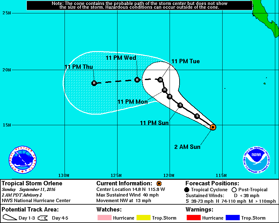
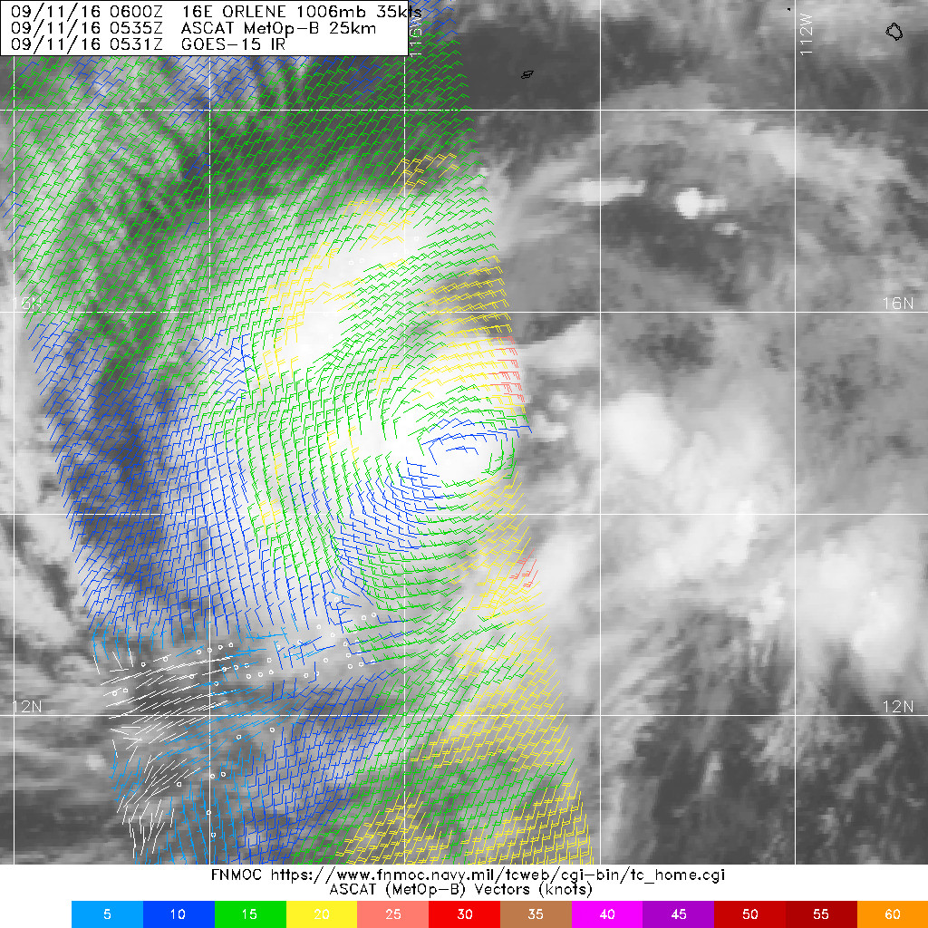
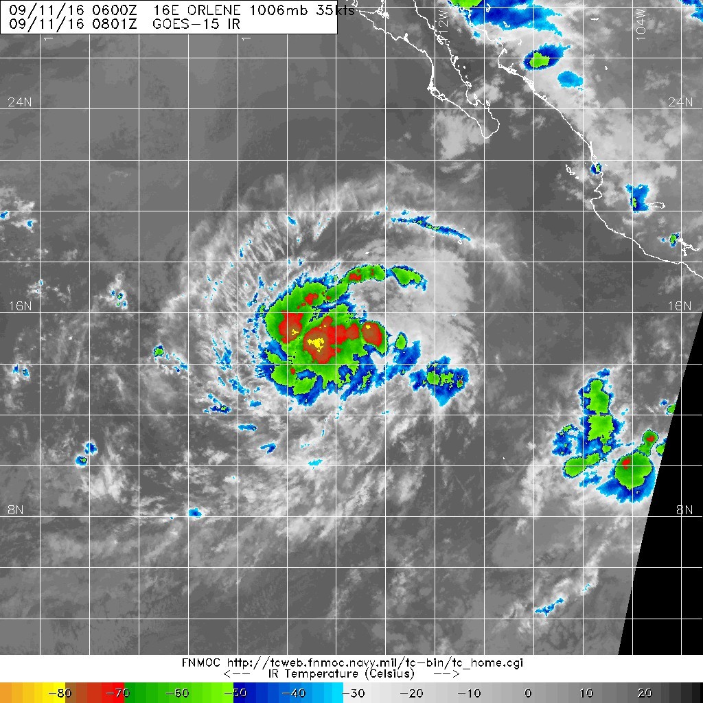
083524W_sm.gif

20160911.0535.mtb.ASCAT.wind.16E.ORLENE.35kts-1006mb.145N.1154W.25km.jpg

20160911.0801.goes-15.ircolor.16E.ORLENE.35kts.1006mb.14.5N.115.4W.100pc.jpg
回復

使用道具 舉報

簽到天數: 3279 天

[LV.Master]伴壇終老

t02436|2016-9-12 16:47 | 顯示全部樓層
發展得比預期好,09Z已經評價70節,站上C1,巔峰改上望90節
ZCZC MIATCDEP1 ALL
TTAA00 KNHC DDHHMM

HURRICANE ORLENE DISCUSSION NUMBER   6
NWS NATIONAL HURRICANE CENTER MIAMI FL       EP162016
200 AM PDT MON SEP 12 2016

Orlene continues to strength.  Satellite images indicate that the
relatively compact tropical cyclone has become better organized
since the previous advisory with an eye occasionally evident in
infrared images. Recent microwave data also indicate that the inner
core of the cyclone is better defined.  Dvorak classifications from
TAFB and SAB were 4.0/65 kt and 4.5/77 kt, respectively, and
automated values from CIMSS at the University of Wisconsin are
4.4/75 kt.  Based on these data, the initial wind speed is increased
to 70 kt, making Orlene a category 1 hurricane on the Saffir-Simpson
Hurricane Wind Scale.  Orlene has strengthened at a rapid rate of 35
kt during the past 24 hours.

The hurricane is moving northwestward, or 305 degrees, at 8 kt.  A
trough over the U.S. Pacific northwest is expected to dig southward
during the next day or two, causing a significant weakness in the
subtropical ridge.  This pattern change should cause Orlene to turn
northwestward or northward and slow down later today, and the
cyclone will likely come to a crawl in the 24-48-hour time period.
Beyond that time, the trough is expected to lift out allowing
ridging to become re-established to the north of the system.  This
should result in Orlene moving westward at a faster pace. The
models are in good agreement on this scenario, and the NHC track
forecast is largely an update of the previous one.

Additional strengthening seems likely during the next 24 hours
while the hurricane remains over warm water, and in an environment
of low wind shear and relatively moist conditions.  After that
time, a slow weakening should commence due to decreasing relative
humidity values and cooler water temperatures, likely aided by
cold water upwelling.  The NHC intensity forecast is near the high
end of the models, in best agreement with the LGEM and Florida
State Superensemble guidance, and is slightly higher than the
previous one in the short term.

FORECAST POSITIONS AND MAX WINDS

INIT  12/0900Z 17.1N 119.1W   70 KT  80 MPH
12H  12/1800Z 17.7N 119.5W   80 KT  90 MPH
24H  13/0600Z 18.5N 119.7W   90 KT 105 MPH
36H  13/1800Z 19.0N 119.8W   85 KT 100 MPH
48H  14/0600Z 19.2N 120.1W   80 KT  90 MPH
72H  15/0600Z 19.2N 122.2W   70 KT  80 MPH
96H  16/0600Z 18.9N 126.5W   65 KT  75 MPH
120H  17/0600Z 19.0N 131.5W   60 KT  70 MPH

$$
Forecaster Cangialosi

NNNN

084006W_sm.gif

rbtop-animated.gif
回復

使用道具 舉報

簽到天數: 2094 天

[LV.Master]伴壇終老

周子堯@FB|2016-9-17 20:55 | 顯示全部樓層
JTWC判定消散
ep1616.gif
回復

使用道具 舉報

快速回覆
您需要登錄後才可以回帖 登錄 | 立即加入

本版積分規則

劉瑞益@FB

    主題

    帖子

    104萬

    積分

    13級[一級颶風]

    Rank: 13Rank: 13Rank: 13Rank: 13

13級[一級颶風]

發訊息

本平台僅供學術討論之用,預報應以氣象局為準

威普網站虛擬主機贊助公司

臺灣第一個天氣類型社群平台 即時天氣資訊、精準颱風動態

線上客服
FB傳送訊息
廣告行銷
精準行銷 物超所值
官方粉專
發佈 快速回復 返回頂部 返回列表