開啟輔助訪問
 找回密碼
 立即加入

18E.Roslyn 北上減弱消散

簽到天數: 2414 天

[LV.Master]伴壇終老

2016-9-21 09:36 | 顯示全部樓層
  熱帶風暴  
編號:18 E
名稱:Roslyn
18E.jpg

  基本資料  
擾動編號日期:2016 09 21 08
命名日期  :2016 09 26 17
撤編日期  :2016 10 01 13
登陸地點  :

  巔峰時期資料  
近中心最強風速:45  kt ( TS )
海平面最低氣壓:1000 百帕

  過去路徑圖  
TWTYBBS_18E.ROSLYN_TRACK_t02436_TWTYBBS.jpg

  討論帖圖片  
94E.INVEST.20kts.1010mb.10N.108W

20160920.2345.goes-13.ircolor.94E.INVEST.20kts.1010mb.10N.108W.100pc.jpg

NHC:30%
1. A broad area of low pressure located about 750 miles south-southwest
of Manzanillo, Mexico, is producing a large area of disorganized
cloudiness and thunderstorms.  Environmental conditions are expected
to be conducive for gradual development during the next several
days, and a tropical depression could form later this week.  This
system is forecast to move generally westward at around 10 mph for
the next couple of days, and then turn northwestward and then
northward by the weekend.
* Formation chance through 48 hours...low...30 percent
* Formation chance through 5 days...medium...60 percent two_pac_2d1.png

以上資料來自:NHC、颱風論壇整理製作

評分

參與人數 1水氣能量 +15 +1 收起 理由
king111807 + 15 + 1 熱帶擾動首帖

查看全部評分

回復

使用道具 舉報

簽到天數: 3279 天

[LV.Master]伴壇終老

t02436|2016-9-26 00:55 | 顯示全部樓層
NHC 17Z發布Special Advisory,升格18E,看來是水貨一個。
000
WTPZ43 KNHC 251652
TCDEP3

TROPICAL DEPRESSION EIGHTEEN-E SPECIAL DISCUSSION NUMBER   1
NWS NATIONAL HURRICANE CENTER MIAMI FL       EP182016
1000 AM PDT SUN SEP 25 2016

Deep convection associated with the low pressure area located well
southwest of the Baja California has become better organized
overnight, and early morning visible satellite imagery indicate
that the circulation has become better defined.  Based on these
observations, and Dvorak classifications of T2.0 and T1.5 from
TAFB and SAB respectively, advisories are being initiated on a
30-kt tropical depression at this time.  The depression is currently
located over warm water and within an area of low vertical wind
shear, which is favorable for some gradual strengthening today.
However, in about 24 hours, the tropical cyclone is forecast to move
into an area of higher southwesterly shear caused by large mid- to
upper-level low and associated trough over northwestern Mexico.  The
global models suggest that the shear will become quite strong in 36
to 48 hours as the cyclone begins moving over cooler waters. This
should result in a rapid spin down, and the system is likely to
become a post-tropical remnant low within 3 days.  The official
intensity foreast is slightly above the SHIPS guidance but is in
good agreement with the intensity consensus.

Since the depression is still in its formative stage, the initial
motion is a somewhat uncertain 360/4 kt.  The cyclone is expected to
be steered slowly northward or north-northeastward during the next
couple of days around the western portion of a weak mid-level ridge
that extends southwestward from southern Mexico.  By 72 hours, the
low should turn northwestward in the low-level steering flow after
it weakens and becomes a vertically shallow system.  Although the
ECMWF and GFS models are on opposite sides of the guidance envelope,
the track models are in general agreement on the overall scenario
and the NHC forecast lies near the multi-model consensus.


FORECAST POSITIONS AND MAX WINDS

INIT  25/1700Z 15.6N 119.7W   30 KT  35 MPH
12H  26/0000Z 16.2N 119.6W   35 KT  40 MPH
24H  26/1200Z 16.8N 119.4W   40 KT  45 MPH
36H  27/0000Z 17.4N 119.1W   40 KT  45 MPH
48H  27/1200Z 18.5N 118.3W   40 KT  45 MPH
72H  28/1200Z 21.0N 117.3W   30 KT  35 MPH
96H  29/1200Z 23.0N 118.0W   25 KT  30 MPH...POST-TROP/REMNT LOW
120H  30/1200Z 24.5N 119.5W   20 KT  25 MPH...POST-TROP/REMNT LOW

$$
Forecaster Brown

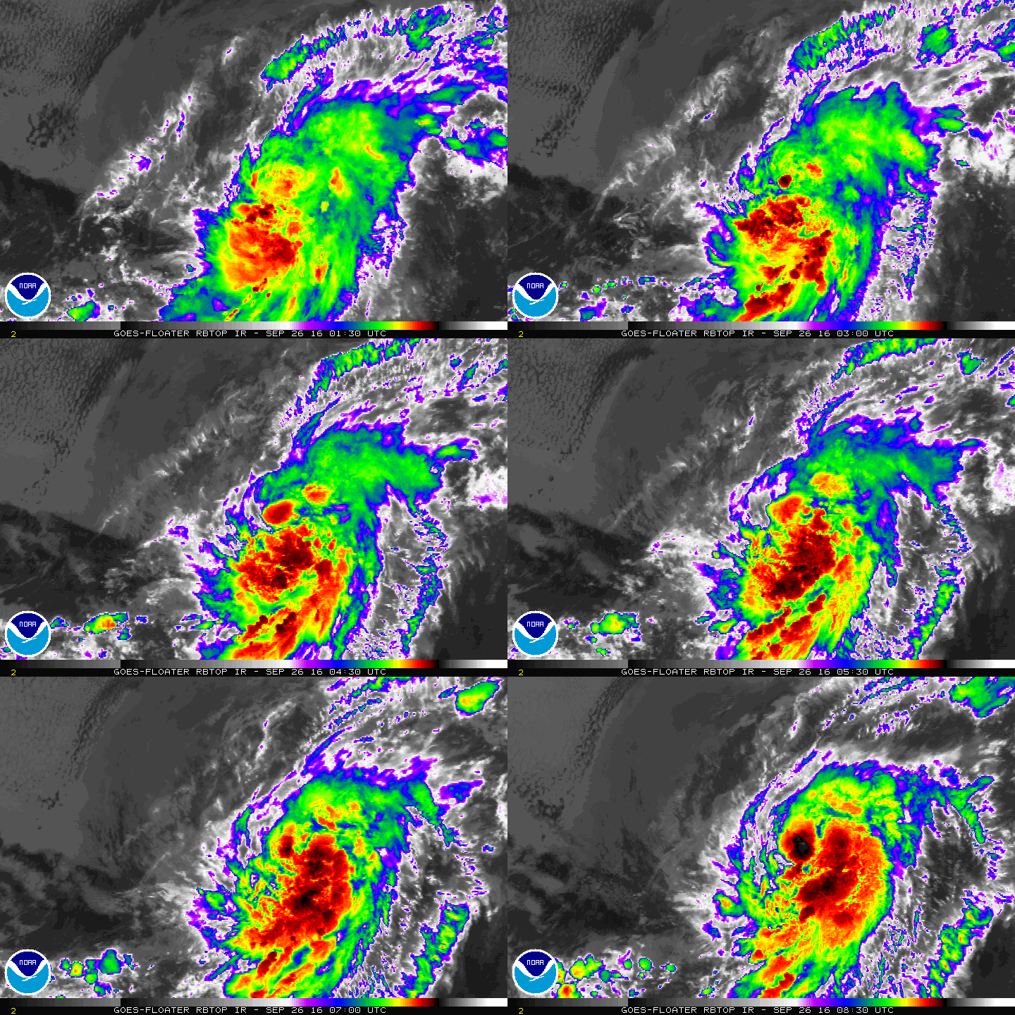
165242W_sm.gif

rbtop-animated.gif
回復

使用道具 舉報

簽到天數: 3279 天

[LV.Master]伴壇終老

t02436|2016-9-26 16:53 | 顯示全部樓層
命名Roslyn,NHC認為35Kts就是顛峰強度。
000
WTPZ43 KNHC 260835
TCDEP3

TROPICAL STORM ROSLYN DISCUSSION NUMBER   4
NWS NATIONAL HURRICANE CENTER MIAMI FL       EP182016
200 AM PDT MON SEP 26 2016

The sheared cloud pattern in infrared satellite imagery has changed
little since the previous advisory. However, a 0304Z SSMI/S pass
indicated the low-level structure had improved markedly, with a
sharp hooked band wrapping more than half around the now
well-defined low-level circulation center. The initial intensity has
been increased to 35 kt based on a Dvorak classification of T2.5/35
kt from TAFB and the improved low-level structure indicated in
SSMI/S 37 GHZ data. This makes Roslyn the seventeenth named storm of
the 2016 eastern North Pacific hurricane season.

The initial motion estimate is 020/4 kt. The advisory position had
to be adjusted more than 30 nmi to the east of the previous advisory
track based on recent SSMI/S and AMSU microwave center fixes.
Otherwise, the previous track forecast rationale remains unchanged.
A large mid- to upper-level low currently located over the central
Baja California peninsula is expected to continue moving westward to
west-southwestward during the next day or two. The combined
southwesterly flow between that low and a deep-layer ridge located
to the east and southeast of Roslyn should keep the tropical cyclone
moving slowly north-northeastward to northeastward for the next 48
hours. After that, Roslyn is expected to weaken into a shallow
remnant low, turning northward on day 3 and then northwestward on
day 4. The new NHC track forecast is to the right of the previous
advisory track, mainly due to the more eastward initial position,
and lies close to the various consensus models.

Little if any strengthening is expected due to gradually increasing
southwesterly vertical wind shear and a very dry mid-level moisture
regime characterized by humidity values less than 40 percent. By 36
to 48 hours, the vertical shear is forecast to increase to more than
30 kt, which is expected to erode the deep convection and induce
steady weakening. As a result, Roslyn is forecast to become a
remnant low by 48 hours, but this could occur sooner. The GFS and
ECMWF models show the remnant low dissipating by the end of the
forecast period when Roslyn will be moving over sub-24C SSTs.  The
new intensity forecast is identical to the previous advisory and
closely follows the IVCN intensity consensus model.

FORECAST POSITIONS AND MAX WINDS

INIT  26/0900Z 16.8N 119.5W   35 KT  40 MPH
12H  26/1800Z 17.2N 119.2W   35 KT  40 MPH
24H  27/0600Z 18.0N 118.5W   35 KT  40 MPH
36H  27/1800Z 19.1N 117.6W   35 KT  40 MPH
48H  28/0600Z 20.4N 117.0W   30 KT  35 MPH...POST-TROP/REMNT LOW
72H  29/0600Z 22.5N 117.5W   25 KT  30 MPH...POST-TROP/REMNT LOW
96H  30/0600Z 24.6N 119.0W   20 KT  25 MPH...POST-TROP/REMNT LOW
120H  01/0600Z...DISSIPATED

$$
Forecaster Stewart
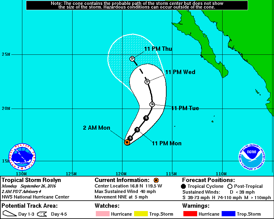
083736W_sm.gif

rbtop-animated.gif
回復

使用道具 舉報

快速回覆
您需要登錄後才可以回帖 登錄 | 立即加入

本版積分規則

本平台僅供學術討論之用,預報應以氣象局為準

威普網站虛擬主機贊助公司

臺灣第一個天氣類型社群平台 即時天氣資訊、精準颱風動態

線上客服
FB傳送訊息
廣告行銷
精準行銷 物超所值
官方粉專
發佈 快速回復 返回頂部 返回列表