開啟輔助訪問
 找回密碼
 立即加入

19E.Ulika 進出中.東太平洋 終散於兩洋交界

簽到天數: 474 天

[LV.9]以壇為家II

2016-9-25 02:35 | 顯示全部樓層
提示: 作者被禁止或刪除 內容自動屏蔽
回復

使用道具 舉報

簽到天數: 474 天

[LV.9]以壇為家II

劉瑞益@FB|2016-9-26 15:09 | 顯示全部樓層
提示: 作者被禁止或刪除 內容自動屏蔽
回復

使用道具 舉報

簽到天數: 3279 天

[LV.Master]伴壇終老

t02436|2016-9-26 22:50 | 顯示全部樓層
NHC升格19E,預測將在140W遊走,四天後才有機會進中太。
000
WTPZ44 KNHC 261445
TCDEP4

TROPICAL DEPRESSION NINETEEN-E DISCUSSION NUMBER   1
NWS NATIONAL HURRICANE CENTER MIAMI FL       EP192016
800 AM PDT MON SEP 26 2016

Scatterometer data from around 0600 UTC indicated that the area of
low pressure located near 140W had a well-defined circulation, with
peak reliable wind vectors of 28 kt.  Deep convection associated
with this system has since become much better organized.  Satellite
classifications are T2.0 and T2.5, and the low is designated as a
tropical depression based on these satellite data.

Light northwesterly shear, warm waters of around 28 deg C and an
increasingly diffluent flow aloft over the cyclone support
intensification during the next 2 to 3 days.  The large divergence
expected over the depression is related to a mid-level cyclone seen
in water vapor imagery near 18N 140W that is forecast to retrograde.
The only negative factor is marginal mid-level moisture that
is forecast to decrease further.  Once the system gains sufficient
latitude after 72 hours, it is likely to become vulnerable to much
stronger westerly flow aloft.  In fact, with 30 to 40 kt of westerly
shear forecast over the cyclone by day 4, rapid weakening should
occur, and the system is forecast to be a remnant low by that time.
The NHC intensity forecast is a blend of the statistical and
dynamical guidance through 72 hours and is below both sets of output
after that time.

The low was moving just south of due west during the last 24 hours,
but appears to have recently turned toward the northwest.  Given
the sudden change in heading, the initial motion estimate of 305/04
is rather uncertain.  Global models show the cyclone turning
northward within 24 hours and then moving north-northeastward after
that for the next few days while it rotates around the mid-level
low to the northwest of the cyclone.  Once the cyclone weakens
appreciably after 72 hours, a turn toward the west is likely when
the remnant low is steered by the trade wind flow.  The NHC track
forecast is a left of the multi-model consensus, close to a
consensus without the GFDL model.


FORECAST POSITIONS AND MAX WINDS

INIT  26/1500Z 11.6N 139.6W   30 KT  35 MPH
12H  27/0000Z 12.0N 139.8W   40 KT  45 MPH
24H  27/1200Z 12.8N 139.5W   45 KT  50 MPH
36H  28/0000Z 13.6N 138.8W   50 KT  60 MPH
48H  28/1200Z 14.4N 138.2W   55 KT  65 MPH
72H  29/1200Z 16.1N 138.0W   50 KT  60 MPH
96H  30/1200Z 17.2N 139.5W   35 KT  40 MPH...POST-TROP/REMNT LOW
120H  01/1200Z 17.3N 142.3W   20 KT  25 MPH...POST-TROP/REMNT LOW

$$
Forecaster Kimberlain

144226W_sm.gif

rbtop-animated.gif

回復

使用道具 舉報

簽到天數: 498 天

[LV.9]以壇為家II

...|2016-9-27 19:11 | 顯示全部樓層
本帖最後由 ... 於 2016-9-27 19:13 編輯
Tropical Storm Ulika Advisory Number 004
Issued at 1100 PM HST MON SEP 26 2016
SUMMARY OF 1100 PM HST...0900 UTC...INFORMATION
-----------------------------------------------
Location: 12.1N 140.4W
ABOUT 1105 MI...1780 KM ESE OF HILO HAWAII
Maximum sustained winds: 40 MPH...65 KM/H
Present movement: N or 350 degrees AT 3 MPH...6 KM/H
Minimum central pressure: 1004 MB...29.65 INCHES

CPHC已命名ULIKA EP192016W.gif

預期將貼著140W北上並偏回東太
回復

使用道具 舉報

簽到天數: 3279 天

[LV.Master]伴壇終老

t02436|2016-9-28 17:17 | 顯示全部樓層
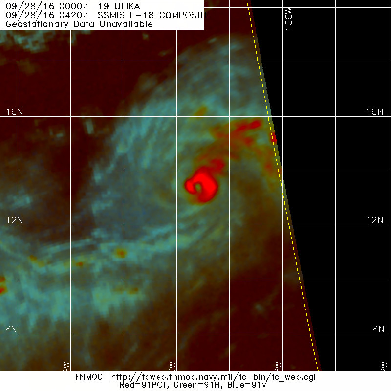
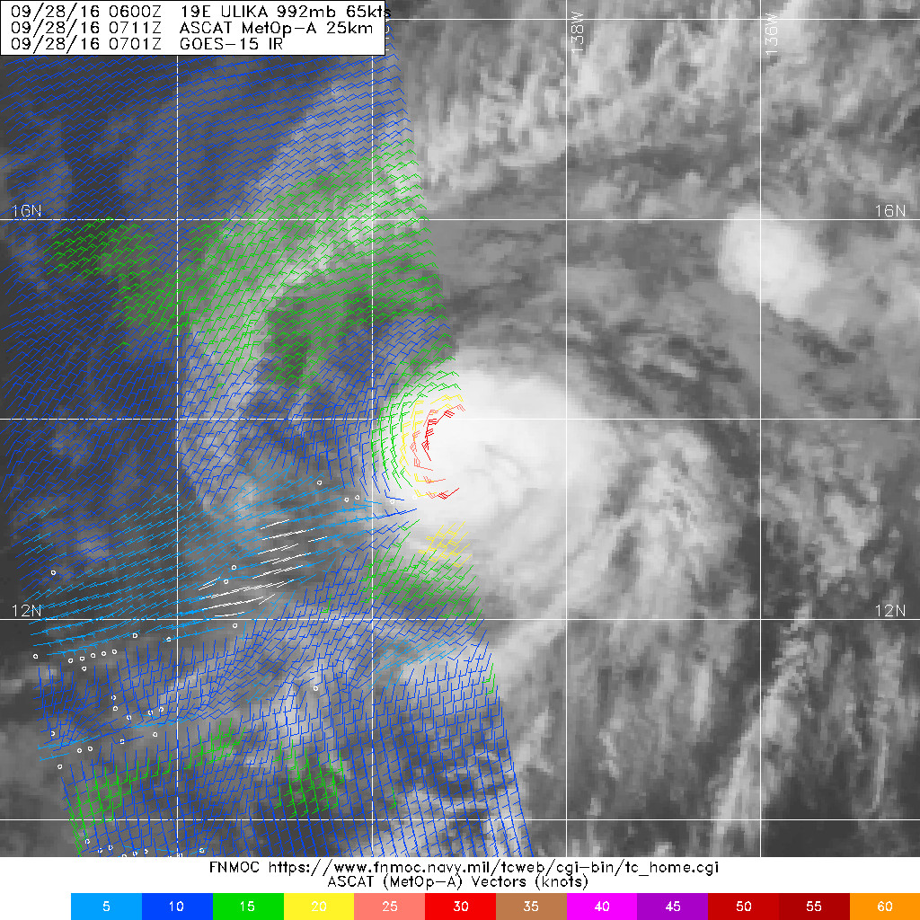
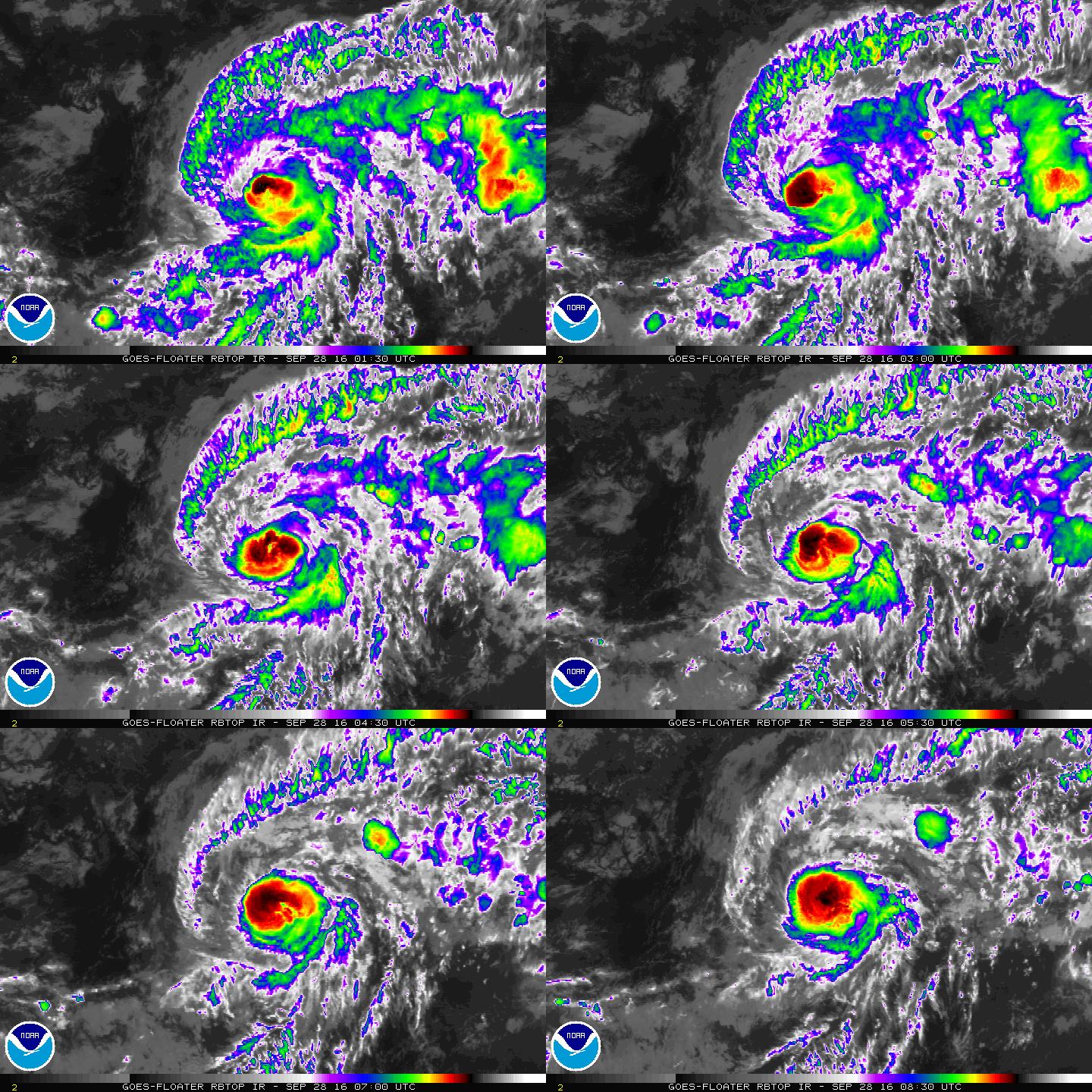
03Z已經跑回東太,底層風眼也建立完成,09Z站上C1,將在12小時之後達到巔峰。
000
WTPZ44 KNHC 280853
TCDEP4

HURRICANE ULIKA DISCUSSION NUMBER   8
NWS NATIONAL HURRICANE CENTER MIAMI FL       EP192016
200 AM PDT WED SEP 28 2016

Ulika has continued to improve in organization, and recent microwave
data have shown that the cyclone has maintained a well-defined eye
in the 89-GHz channel during the past few hours.  Hints of an eye
have also been observed in shortwave infrared imagery, embedded
within a compact central dense overcast.  Subjective satellite
intensity estimates have risen to T4.0/65 kt from TAFB and T3.0/55
kt from SAB, and the objective ADT from UW-CIMSS is even higher
around 75 kt.  A couple of CIMSS AMSU intensity estimates also
provided values of 60-65 kt several hours ago.  Based on these
data, Ulika is upgraded to a hurricane with 65-kt winds, and this
could be conservative.

Ulika has rapidly intensified during the past 24 hours, which in
hindsight was probably helped by the cyclone's small wind field and
radius of maximum winds.  Vertical shear is expected to remain low
for another 12 hours or so, which could allow Ulika to intensify
some more in the short term.  By 24 hours, however, southwesterly
to westerly vertical shear is forecast to increase markedly,
exceeding 30 kt in a couple of days.  Given Ulika's small size, the
cyclone will be particularly sensitive to the increase in shear,
and its intensity is likely to decrease quickly.  Ulika is expected
to become a remnant low by day 4 and then dissipate southeast of
the Hawaiian Islands by day 5.  The NHC intensity forecast is very
close to the intensity consensus for the entire forecast period, and
is higher than the previous forecast during the first 36 hours to
account for Ulika's recent intensification trend.

A mid- to upper-level low northwest of Ulika is steering the
hurricane north-northeastward, or 030/6 kt.  Ulika is expected to
turn northward and northwestward around this feature during the next
couple of days.  After it becomes a weaker system, it should then
come under greater influence from the low-level trades, turning
west-northwestward and westward on days 3 and 4.  With the
exception of the GFDL, which is well north of the rest of the
guidance suite, all of the track models are tightly clustered
during the forecast period.  The NHC track forecast is therefore
close to the various consensus aids and not too different from
the previous advisory.

FORECAST POSITIONS AND MAX WINDS

INIT  28/0900Z 13.9N 139.0W   65 KT  75 MPH
12H  28/1800Z 14.7N 138.9W   70 KT  80 MPH
24H  29/0600Z 15.6N 139.1W   65 KT  75 MPH
36H  29/1800Z 16.4N 139.6W   55 KT  65 MPH
48H  30/0600Z 17.0N 140.6W   45 KT  50 MPH
72H  01/0600Z 17.7N 143.3W   35 KT  40 MPH
96H  02/0600Z 17.7N 147.3W   30 KT  35 MPH...POST-TROP/REMNT LOW
120H  03/0600Z...DISSIPATED

$$
Forecaster Berg
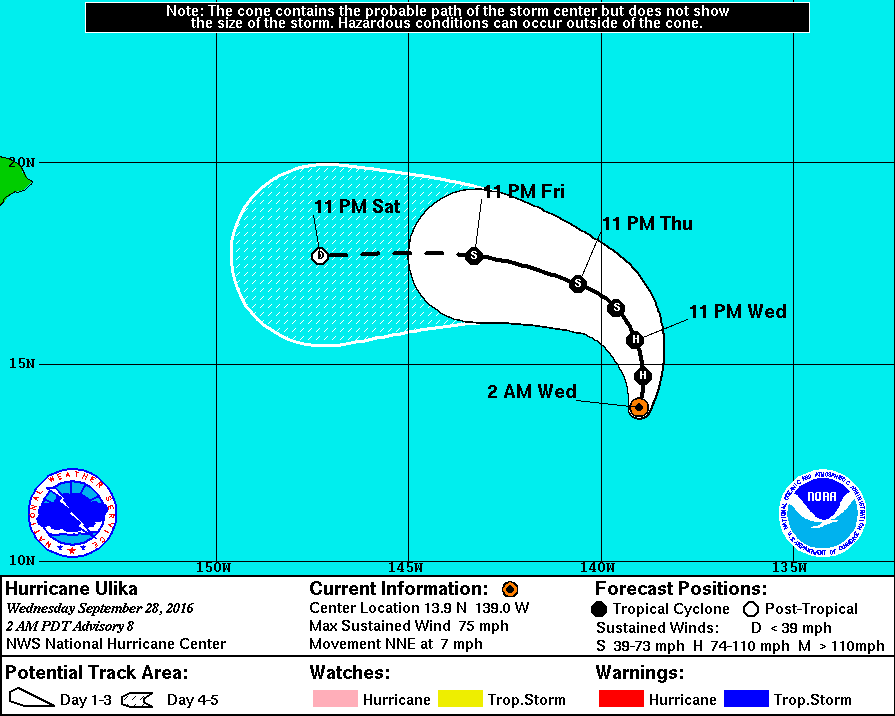
085505W_sm.gif

20160928.0420.f18.91pct91h91v.19E.ULIKA.55kts.997mb.13.1N.139.3W.075pc.jpg

20160928.0711.mta.ASCAT.wind.19E.ULIKA.65kts-992mb.136N.1391W.25km.jpg

rbtop-animated.gif
回復

使用道具 舉報

快速回覆
您需要登錄後才可以回帖 登錄 | 立即加入

本版積分規則

劉瑞益@FB

    主題

    帖子

    104萬

    積分

    13級[一級颶風]

    Rank: 13Rank: 13Rank: 13Rank: 13

13級[一級颶風]

發訊息

本平台僅供學術討論之用,預報應以氣象局為準

威普網站虛擬主機贊助公司

臺灣第一個天氣類型社群平台 即時天氣資訊、精準颱風動態

線上客服
FB傳送訊息
廣告行銷
精準行銷 物超所值
官方粉專
發佈 快速回復 返回頂部 返回列表