開啟輔助訪問
 找回密碼
 立即加入

13P.Debbie 以巔峰強襲昆士蘭 中心登陸逐漸減弱

簽到天數: 588 天

[LV.9]以壇為家II

Meow|2017-3-24 21:10 | 顯示全部樓層
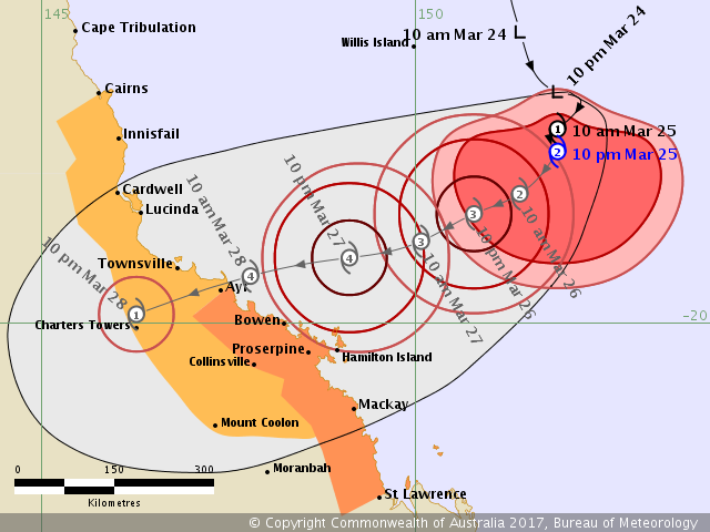
上望四級強烈熱帶氣旋,可能正面襲擊湯斯維爾。
IDQ65001.png
  1. IDQ20018
  2. TROPICAL CYCLONE TECHNICAL BULLETIN: AUSTRALIA - EASTERN REGION
  3. Issued by BRISBANE TROPICAL CYCLONE WARNING CENTRE
  4. at: 1247 UTC 24/03/2017
  5. Name: Tropical Low  
  6. Identifier: 24U
  7. Data At: 1200 UTC
  8. Latitude: 16.9S
  9. Longitude: 151.9E
  10. Location Accuracy: within 25 nm [45 km]
  11. Movement Towards: south southeast [165 deg]
  12. Speed of Movement: 2 knots [5 km/h]
  13. Maximum 10-Minute Wind: 25 knots [45 km/h]
  14. Maximum 3-Second Wind Gust: 45 knots [85 km/h]
  15. Central Pressure: 996 hPa
  16. Radius of 34-knot winds NE quadrant:   
  17. Radius of 34-knot winds SE quadrant:   
  18. Radius of 34-knot winds SW quadrant:   
  19. Radius of 34-knot winds NW quadrant:   
  20. Radius of 48-knot winds NE quadrant:   
  21. Radius of 48-knot winds SE quadrant:   
  22. Radius of 48-knot winds SW quadrant:   
  23. Radius of 48-knot winds NW quadrant:   
  24. Radius of 64-knot winds:   
  25. Radius of Maximum Winds:   
  26. Dvorak Intensity Code: T2.0/2.0/D1.0/24HRS STT: S0.0/06HRS
  27. Pressure of outermost isobar: 1006 hPa
  28. Radius of outermost closed isobar: 200 nm [370 km]
  29. FORECAST DATA
  30. Date/Time    : Location    : Loc. Accuracy: Max Wind   : Central Pressure
  31. [UTC]        : degrees     :      nm  [km]: knots[km/h]: hPa
  32. +06:  24/1800: 17.3S 151.9E:     030 [060]:  030  [055]:  995
  33. +12:  25/0000: 17.4S 151.8E:     045 [080]:  040  [075]:  994
  34. +18:  25/0600: 17.6S 151.7E:     055 [105]:  045  [085]:  991
  35. +24:  25/1200: 17.6S 151.6E:     070 [130]:  050  [095]:  987
  36. +36:  26/0000: 18.0S 151.0E:     090 [165]:  060  [110]:  979
  37. +48:  26/1200: 18.3S 150.3E:     110 [200]:  065  [120]:  975
  38. +60:  27/0000: 18.8S 149.3E:     130 [235]:  080  [150]:  962
  39. +72:  27/1200: 19.0S 148.2E:     145 [270]:  090  [165]:  954
  40. +96:  28/1200: 19.6S 145.2E:     190 [355]:  040  [075]:  995
  41. +120: 29/1200: 20.8S 143.5E:     280 [515]:  025  [045]: 1003
  42. REMARKS:
  43. Position fair based on Willis Island radar imagery and peripheral surface
  44. observations.

  45. The system continues to become slowly organised, with increasing broad curvature
  46. evident and transient bursts of curved convection near the centre. Dvorak
  47. analysis based on a three hourly average of curved bands, averaging to
  48. approximately an 0.35 wrap. DT is therefore 2.0. MET agrees. Final T 2.0.

  49. The system is currently being steered to the south-southeast by the combination
  50. of a mid level ridge to the east, and an upper level trough moving eastwards
  51. across the Tasman Sea. During the weekend, this trough is expected to move
  52. further east, and a new mid level ridge should build to the south of the system,
  53. leading
  54. to a change to a westerly track, taking the cyclone onto the Queensland coast.
  55. All model guidance is in agreement with this scenario, although there are some
  56. differences in forward speed amongst the guidance, which affects not only the
  57. time of impact, but also the length of time available for the system to
  58. intensify over the water.

  59. The system is located in an area of weak vertical wind shear over SSTs of 29 to
  60. 30 deg C. Upper level outflow is good in all quadrants, and may become further
  61. enhanced to the south due to the weak interaction with the upper trough.
  62. Overall, the environment will remain supportive of intensification right up to
  63. landfall on the Queensland coast. The intensity forecast is based on slightly
  64. more than a standard rate of intensification; given the favourable environment
  65. it is likely that there will be periods of more rapid intensification.

  66. Copyright Commonwealth of Australia
  67. ==
  68. The next bulletin for this system will be issued by: 24/1930 UTC by Brisbane
  69. TCWC.
複製代碼

點評

上看10分鐘平均風速100kts,氣壓930hpa(相當於強烈颱風)  發表於 2017-3-24 23:23
回復

使用道具 舉報

簽到天數: 2095 天

[LV.Master]伴壇終老

周子堯@FB|2017-3-25 10:43 | 顯示全部樓層
JTWC第一報估顛峰度達95KT sh1317.gif


回復

使用道具 舉報

簽到天數: 3279 天

[LV.Master]伴壇終老

t02436|2017-3-25 11:46 | 顯示全部樓層
BoM命名報
IDQ20018
TROPICAL CYCLONE TECHNICAL BULLETIN: AUSTRALIA - EASTERN REGION
Issued by BRISBANE TROPICAL CYCLONE WARNING CENTRE
at: 0135 UTC 25/03/2017
Name: Tropical Cyclone Debbie
Identifier: 24U
Data At: 0000 UTC
Latitude: 17.4S
Longitude: 151.9E
Location Accuracy: within 20 nm [35 km]
Movement Towards: southwest [216 deg]
Speed of Movement: 5 knots [9 km/h]
Maximum 10-Minute Wind: 35 knots [65 km/h]
Maximum 3-Second Wind Gust: 50 knots [95 km/h]
Central Pressure: 992 hPa
Radius of 34-knot winds NE quadrant: 110 nm [205 km]
Radius of 34-knot winds SE quadrant: 120 nm [220 km]
Radius of 34-knot winds SW quadrant: 120 nm [220 km]
Radius of 34-knot winds NW quadrant: 110 nm [205 km]
Radius of 48-knot winds NE quadrant:   
Radius of 48-knot winds SE quadrant:   
Radius of 48-knot winds SW quadrant:   
Radius of 48-knot winds NW quadrant:   
Radius of 64-knot winds:   
Radius of Maximum Winds: 20 nm [35 km]
Dvorak Intensity Code: T3.0/3.0/D1.0/24HRS
Pressure of outermost isobar: 1010 hPa
Radius of outermost closed isobar: 330 nm [610 km]
FORECAST DATA
Date/Time    : Location    : Loc. Accuracy: Max Wind   : Central Pressure
[UTC]        : degrees     :      nm  [km]: knots[km/h]: hPa
+06:  25/0600: 17.6S 151.8E:     030 [060]:  040  [075]:  991
+12:  25/1200: 17.7S 151.7E:     045 [080]:  045  [085]:  987
+18:  25/1800: 17.9S 151.4E:     055 [105]:  055  [100]:  985
+24:  26/0000: 18.0S 151.1E:     070 [130]:  060  [110]:  979
+36:  26/1200: 18.4S 150.4E:     090 [165]:  070  [130]:  975
+48:  27/0000: 18.9S 149.5E:     110 [200]:  080  [150]:  962
+60:  27/1200: 19.2S 148.4E:     130 [235]:  090  [165]:  954
+72:  28/0000: 19.5S 146.8E:     145 [270]:  085  [155]:  950
+96:  29/0000: 20.4S 144.1E:     190 [355]:  030  [055]: 1001
+120: 30/0000: 21.4S 144.4E:     280 [515]:  025  [045]: 1003
REMARKS:
The tropical low has recently developed into Tropical Cyclone Debbie. The system
is associated with an impressive, very large circulation, but until recently has
shown little development near the centre. However, it continues to become slowly
organised, particularly near the centre, where convection is finally becoming
more sustained. The latest Dvorak analysis was based on a curved band pattern
with a 0.6 degree wrap, giving a DT of 3.0. MET and PAT were both 3.0. This
analysis was supported by observations of sustained gales from Marion Reef.

Confidence in the location of the system is considered good based on animated
visible imagery, Willis Island radar and surface observations from Lihou Reef.
Pressure observations have declined significantly at Lihou Reef over the last 24
hour with an MSLP observation of 991.8hPa at 18 UTC 24/3.

Until recently, the system was being steered to the southeast by the combination
of a mid level ridge to the east, and an upper level trough moving eastwards
across the Tasman Sea. In the last few hours, the expected shift onto a west
southwesterly track has been evident, as the upper trough moves further east,
and a new mid level ridge builds to the south of the system. The latter is
expected to remain the dominant steering mechanism over the next few days,
keeping the cyclone on a west-southwesterly track and taking the cyclone onto
the Queensland coast. Given such a large circulation, it can be expected that
the system will have some effect back onto the surrounding steering systems --
this is part of the reason for the drift to more southerly tracks recently. All
model guidance is in agreement with this scenario, although there remain some
differences in forward speed amongst the guidance, which affects not only the
time of impact, but also the length of time available for the system to
intensify over the water. It should also be noted that a significant proportion
of EC Ensemble tracks remain to the north of the current cluster of
deterministic forecasts, taking the system onto the coast north of Cardwell.

The system is located in an area of weak vertical wind shear over SSTs of 29 to
30 degrees celcius. Upper level outflow is excellent in all quadrants. Overall,
the environment will remain supportive of intensification right up to landfall
on the Queensland coast. The intensity forecast is based on slightly more than a
standard rate of intensification; given the favourable environment it is likely
that there will be periods of more rapid intensification.

Copyright Commonwealth of Australia
==
The next bulletin for this system will be issued by: 25/0730 UTC by Brisbane
TCWC.

IDQ65001.png

rbtop-animated.gif
回復

使用道具 舉報

簽到天數: 588 天

[LV.9]以壇為家II

Meow|2017-3-25 20:28 | 顯示全部樓層
罕見超暴力圍眼即將完成
20170325_1130Z-rbtop.gif
20170325_1130Z-bd.gif
回復

使用道具 舉報

簽到天數: 588 天

[LV.9]以壇為家II

Meow|2017-3-25 21:27 | 顯示全部樓層
BoM升二級熱帶氣旋,JTWC提升到65kt。
IDQ65001.png
  1. IDQ20018
  2. TROPICAL CYCLONE TECHNICAL BULLETIN: AUSTRALIA - EASTERN REGION
  3. Issued by BRISBANE TROPICAL CYCLONE WARNING CENTRE
  4. at: 1310 UTC 25/03/2017
  5. Name: Tropical Cyclone Debbie
  6. Identifier: 24U
  7. Data At: 1200 UTC
  8. Latitude: 17.7S
  9. Longitude: 151.9E
  10. Location Accuracy: within 30 nm [55 km]
  11. Movement Towards: south [180 deg]
  12. Speed of Movement: 2 knots [3 km/h]
  13. Maximum 10-Minute Wind: 55 knots [100 km/h]
  14. Maximum 3-Second Wind Gust: 75 knots [140 km/h]
  15. Central Pressure: 985 hPa
  16. Radius of 34-knot winds NE quadrant: 110 nm [205 km]
  17. Radius of 34-knot winds SE quadrant: 140 nm [260 km]
  18. Radius of 34-knot winds SW quadrant: 140 nm [260 km]
  19. Radius of 34-knot winds NW quadrant: 110 nm [205 km]
  20. Radius of 48-knot winds NE quadrant: 30 nm [55 km]
  21. Radius of 48-knot winds SE quadrant: 90 nm [165 km]
  22. Radius of 48-knot winds SW quadrant: 90 nm [165 km]
  23. Radius of 48-knot winds NW quadrant: 30 nm [55 km]
  24. Radius of 64-knot winds:   
  25. Radius of Maximum Winds: 30 nm [55 km]
  26. Dvorak Intensity Code: T3.5/3.5/D1.5/24HRS STT:D0.5/06HRS
  27. Pressure of outermost isobar: 1006 hPa
  28. Radius of outermost closed isobar: 200 nm [370 km]
  29. FORECAST DATA
  30. Date/Time    : Location    : Loc. Accuracy: Max Wind   : Central Pressure
  31. [UTC]        : degrees     :      nm  [km]: knots[km/h]: hPa
  32. +06:  25/1800: 18.0S 151.7E:     035 [065]:  060  [110]:  984
  33. +12:  26/0000: 18.3S 151.4E:     040 [075]:  060  [110]:  979
  34. +18:  26/0600: 18.4S 151.1E:     045 [085]:  065  [120]:  974
  35. +24:  26/1200: 18.5S 150.8E:     050 [095]:  070  [130]:  970
  36. +36:  27/0000: 18.9S 150.1E:     075 [140]:  080  [150]:  961
  37. +48:  27/1200: 19.1S 149.1E:     090 [165]:  090  [165]:  953
  38. +60:  28/0000: 19.4S 147.8E:     095 [180]:  100  [185]:  946
  39. +72:  28/1200: 19.9S 146.3E:     110 [205]:  045  [080]:  993
  40. +96:  29/1200: 21.2S 144.5E:     155 [285]:  030  [055]:  999
  41. +120: 30/1200: 21.6S 146.6E:     200 [370]:  025  [045]: 1004
  42. REMARKS:
  43. Tropical cyclone Debbie has been slow moving for the past 12 hours. It has
  44. continued to improve in organisation, and is currently undergoing a significant
  45. convective burst near the centre. This has been reflected in the steady increase
  46. of peripheral wind observations.

  47. Confidence in the centre position is fair to good based on animated IR satellite
  48. imagery, imagery from Willis Island radar, and peripheral observations.

  49. Intensity is analysed at 55 knots [10 minute mean]. Dvorak analysis using curved
  50. bands has averaged DT3.0 over the previous three hours, but this average has
  51. increased to DT3.5 during the hour and a half prior to the 12UTC analysis
  52. [0.65-0.7 wrap with +0.5T for the band being white or colder]. MET and PAT are
  53. 3.0. Final T is 3.5. Automatic weather stations at Marion Reef [approximately 90
  54. nautical miles south of the system] and at Lihou Reef [approximately 40 nautical
  55. miles north] have peaked at 50 and 46 knots respectively [10 minute mean],
  56. supporting the analysed intensity. The intensity is also supported by ADT
  57. values. The observations and surrounding convection suggest an asymmetric wind
  58. structure at present, which is forecast to become more symmetrical as the system
  59. increases its organisation. The pressure at Lihou Reef is dropping against the
  60. diurnal trend [991.8hPa at 12UTC].

  61. Steering has been weak for the past 12 hours, however CIMSS satellite winds
  62. suggest a mid-level ridge building to the south of the system as forecast. This
  63. will steer the system to the west-southwest for the next several days until
  64. landfall on the Queensland coast, expected overnight Monday or Tuesday morning.
  65. Deterministic NWP models all follow this scenario with landfalls occurring
  66. broadly between Lucinda and Mackay on the Queensland coast. MOGREPS and GFS
  67. ensembles are consistent with this, although a number of 00Z ECMWF ensemble
  68. members have landfalls further north between Cairns and Lucinda.

  69. The system remains located in an area of weak vertical wind shear over SSTs of
  70. 29 to 30 degrees celsius. Upper level outflow is excellent in all quadrants.
  71. Conditions will remain favourable for development right up until landfall, and
  72. this has been reflected in an intensity forecast at slightly above the standard
  73. rate. This is generally on the high end of the objective guidance spectrum,
  74. although HWRF and recent SHIPS guidance are similar. Given the supportive
  75. environment, it is likely that there will be periods of more rapid
  76. intensification, and the intensity may be higher than forecast.

  77. Copyright Commonwealth of Australia
  78. ==
  79. The next bulletin for this system will be issued by: 25/1930 UTC by Brisbane
  80. TCWC.
複製代碼


SH, 13, 2017032512,   , BEST,   0, 179S, 1521E,  65,  982, TY,

現在BoM是3小時發報一次。
回復

使用道具 舉報

簽到天數: 1988 天

[LV.Master]伴壇終老

ben811018|2017-3-26 17:26 | 顯示全部樓層


今天的連續雲圖
回復

使用道具 舉報

簽到天數: 588 天

[LV.9]以壇為家II

Meow|2017-3-27 11:14 | 顯示全部樓層
終究爆發了
0230Z.png
回復

使用道具 舉報

簽到天數: 3279 天

[LV.Master]伴壇終老

t02436|2017-3-27 11:29 | 顯示全部樓層
站上澳式C3,還有一天左右時間可以發展。
IDQ20018
TROPICAL CYCLONE TECHNICAL BULLETIN: AUSTRALIA - EASTERN REGION
Issued by BRISBANE TROPICAL CYCLONE WARNING CENTRE
at: 0119 UTC 27/03/2017
Name: Severe Tropical Cyclone Debbie
Identifier: 24U
Data At: 0000 UTC
Latitude: 19.1S
Longitude: 150.4E
Location Accuracy: within 20 nm [35 km]
Movement Towards: south southwest [199 deg]
Speed of Movement: 4 knots [7 km/h]
Maximum 10-Minute Wind: 65 knots [120 km/h]
Maximum 3-Second Wind Gust: 90 knots [165 km/h]
Central Pressure: 975 hPa
Radius of 34-knot winds NE quadrant: 110 nm [205 km]
Radius of 34-knot winds SE quadrant: 140 nm [260 km]
Radius of 34-knot winds SW quadrant: 140 nm [260 km]
Radius of 34-knot winds NW quadrant: 110 nm [205 km]
Radius of 48-knot winds NE quadrant: 40 nm [75 km]
Radius of 48-knot winds SE quadrant: 40 nm [75 km]
Radius of 48-knot winds SW quadrant: 40 nm [75 km]
Radius of 48-knot winds NW quadrant: 40 nm [75 km]
Radius of 64-knot winds: 30 nm [55 km]
Radius of Maximum Winds: 25 nm [45 km]
Dvorak Intensity Code: T4.5/T4.5/D1.0/24HRS
Pressure of outermost isobar: 1006 hPa
Radius of outermost closed isobar: 200 nm [370 km]
FORECAST DATA
Date/Time    : Location    : Loc. Accuracy: Max Wind   : Central Pressure
[UTC]        : degrees     :      nm  [km]: knots[km/h]: hPa
+06:  27/0600: 19.5S 150.1E:     025 [050]:  070  [130]:  970
+12:  27/1200: 19.6S 149.6E:     040 [070]:  080  [150]:  961
+18:  27/1800: 19.9S 148.9E:     050 [095]:  090  [165]:  953
+24:  28/0000: 20.2S 148.2E:     065 [120]:  080  [150]:  963
+36:  28/1200: 20.6S 146.7E:     085 [155]:  040  [075]:  994
+48:  29/0000: 21.3S 145.4E:     105 [190]:  030  [055]: 1001
+60:  29/1200: 22.1S 145.2E:     125 [230]:  030  [055]:  999
+72:  30/0000: 23.4S 146.7E:     140 [265]:  030  [050]: 1001
+96:  31/0000: 25.1S 151.7E:     185 [345]:  025  [045]: 1003
+120: 01/0000: 27.6S 155.8E:     275 [505]:  025  [045]: 1003
REMARKS:
Tropical cyclone Debbie showed little signs of development through the previous
24 hours to sunrise this morning. However in the past few hours, the long
expected rapid development appears to be taking place.  Deep convection has
rapidly dveloped around the system centre, with possibly a ragged eye feature
appearing. The latest Dvorak analysis was therefore based on an eye pattern in
IR, with a DG surround and OW eye, subtracting 0.5 for ragged eye yielded a DT
of 4.0. MET and is 5.0 and PT is 4.5. FT was based on PT as the DT was not
completely clear. SATCON has jumped dramatically over the past 6 hours from 62
knots to 90 knots. ADT from both agencies are around 5.0 System will be upgraded
to a severe category 3.

Confidence in the centre position is rated as good based on a combination of
radar imagery from Willis Island and Bowen radars and animated visible satellite
imagery.

The mid-level ridge building to the south of the system has become the primary
steering influence. However, animated WV imagery suggests that the shortwave
trough moving north into SE Queensland may have a little more amplitude than the
models are suggesting, leading to a slight weakening of the ridge and a slightly
more southerly track which has been evident over the past 12 hours. There may
also be some influence from internal processes within the cyclone core, where it
remains somewhat disorganised. Overall, the system is most likely to remain on a
general west-southwest track for the next 24 hours up to landfall on the
Queensland coast. There is still reasonably high confidence in this track,
although there is more uncertainty on the southern side.

The system remains located in an area of weak vertical wind shear over sea
surface temperatures of 29 to 30 degrees Celsius. Conditions will remain
favourable for development right up until landfall, and this has been reflected
in an intensity forecast at above the standard rate, reinforced by the recent
fairly rapid development. This is above most objective guidance at this time.
The forecast allows for a period of rapid intensification to occur before
landfall in the favourable environment, which recent SHIPS guidance suggests is
a possibility.

Copyright Commonwealth of Australia
==
The next bulletin for this system will be issued by: 27/0730 UTC by Brisbane
TCWC.

IDQ65001.png

rbtop-animated.gif
回復

使用道具 舉報

快速回覆
您需要登錄後才可以回帖 登錄 | 立即加入

本版積分規則

本平台僅供學術討論之用,預報應以氣象局為準

威普網站虛擬主機贊助公司

臺灣第一個天氣類型社群平台 即時天氣資訊、精準颱風動態

線上客服
FB傳送訊息
廣告行銷
精準行銷 物超所值
官方粉專
發佈 快速回復 返回頂部 返回列表