簽到天數: 3291 天 [LV.Master]伴壇終老
|
 t02436|2017-5-10 09:43
|
顯示全部樓層
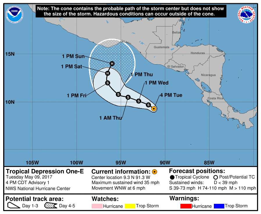
NHC 2017東太平洋熱帶氣旋報文第一報存檔
000
WTPZ41 KNHC 092039
TCDEP1
Tropical Depression One-E Discussion Number 1
NWS National Hurricane Center Miami FL EP012017
400 PM CDT Tue May 09 2017
The cloud pattern of the low pressure area located a few hundred
miles south-southwest of El Salvador has continued to become better
organized, with developing convective banding features. Also, data
from a recent ASCAT overpass showed that a closed circulation has
developed. Therefore advisories are being initiated on this system.
The intensity is set at 30 kt in agreement with the scatterometer
measurements and a Dvorak classification from SAB. The tropical
cyclone is expected to remain over warm waters of SSTs near 30 deg C
through the forecast period, and the global models show the system
remaining beneath an upper-level anticyclone with well-defined
outflow. Thus, strengthening is likely and the official intensity
forecast is a little below the intensity model consensus.
Geostationary satellite and scatterometer fixes indicate that the
initial motion is 300/5 kt. The tropical cyclone is expected to be
situated to the south of a mid-level anticyclone, centered over the
southwestern Gulf of Mexico, for the next several days. This
steering pattern should maintain a general west-northwestward motion
through 72 hours or so. Later in the forecast period, the
anticyclone is predicted to weaken and this should induce a turn to
the north. The official track forecast is roughly in the middle of
the dynamical track guidance, and is between the GFS and ECMWF
solutions.
FORECAST POSITIONS AND MAX WINDS
INIT 09/2100Z 9.3N 91.3W 30 KT 35 MPH
12H 10/0600Z 9.7N 91.9W 35 KT 40 MPH
24H 10/1800Z 10.1N 93.0W 40 KT 45 MPH
36H 11/0600Z 10.5N 94.2W 45 KT 50 MPH
48H 11/1800Z 10.8N 95.3W 50 KT 60 MPH
72H 12/1800Z 12.0N 96.5W 60 KT 70 MPH
96H 13/1800Z 13.0N 96.5W 70 KT 80 MPH
120H 14/1800Z 14.0N 96.0W 80 KT 90 MPH
$$
Forecaster Pasch

|
|