開啟輔助訪問
 找回密碼
 立即加入

07E.Greg 乾空氣影響 將逐漸減弱

簽到天數: 474 天

[LV.9]以壇為家II

2017-7-15 06:46 | 顯示全部樓層
提示: 作者被禁止或刪除 內容自動屏蔽
回復

使用道具 舉報

簽到天數: 474 天

[LV.9]以壇為家II

劉瑞益@FB|2017-7-15 19:41 | 顯示全部樓層
提示: 作者被禁止或刪除 內容自動屏蔽
回復

使用道具 舉報

簽到天數: 474 天

[LV.9]以壇為家II

劉瑞益@FB|2017-7-17 08:58 | 顯示全部樓層
提示: 作者被禁止或刪除 內容自動屏蔽
回復

使用道具 舉報

簽到天數: 971 天

[LV.10]以壇為家III

jwpk9899|2017-7-17 23:06 | 顯示全部樓層
升格07E 強度上不看好
ep0717.gif
回復

使用道具 舉報

簽到天數: 3279 天

[LV.Master]伴壇終老

t02436|2017-7-18 17:05 | 顯示全部樓層
NHC命名Greg。
000
WTPZ42 KNHC 180840
TCDEP2

Tropical Storm Greg Discussion Number   4
NWS National Hurricane Center Miami FL       EP072017
300 AM MDT Tue Jul 18 2017

Deep convection has increased in both intensity and coverage during
the last several hours over and to the southeast of the center of
the cyclone.  The Dvorak classifications from TAFB and SAB at 0600
UTC were 2.0/30 kt, but ADT values and satellite consensus estimates
from CIMSS at the University of Wisconsin suggest a slightly higher
intensity.  Based on the improvement in convective organization
during the past few hours, the initial intensity is increased to 35
kt, making the system Tropical Storm Greg.

The northwesterly shear currently affecting Greg is expected to
gradually lessen, and the upper-level wind pattern will likely
become favorable in the 24- to 60-h time frame.  Therefore, the NHC
intensity forecast continues to show modest strengthening during the
next couple of days.  After that time, however, the shear is
expected to increase out of the south or southwest as the cyclone
approaches an upper-level low. This increase in shear combined with
drier air and cooler waters should end the strengthening trend and
cause weakening.  The depression will likely degenerate to a remnant
low in 4 to 5 days when it moves over SSTs below 26 deg C.  The NHC
intensity forecast is the same as the previous one, and is in line
with the bulk of the guidance.

Greg is moving west-northwestward at 8 kt to the south of a low- to
mid-level ridge.  A westward to west-northwestward motion with some
increase in forward speed is expected during the next few days as
the ridge strengthens a little.  Some of the models show Greg
interacting with the disturbance currently located about 700 n mi
to its west in 4 to 5 days, which could cause the cyclone to turn
south of due west at that time.  The track models are in general
agreement, and the NHC forecast lies closest to the consensus aids.

FORECAST POSITIONS AND MAX WINDS

INIT  18/0900Z 14.6N 107.6W   35 KT  40 MPH
12H  18/1800Z 14.7N 108.7W   35 KT  40 MPH
24H  19/0600Z 15.0N 110.6W   40 KT  45 MPH
36H  19/1800Z 15.4N 112.6W   40 KT  45 MPH
48H  20/0600Z 15.8N 114.7W   40 KT  45 MPH
72H  21/0600Z 16.9N 119.7W   35 KT  40 MPH
96H  22/0600Z 17.1N 124.6W   30 KT  35 MPH
120H  23/0600Z 16.5N 129.5W   25 KT  30 MPH...POST-TROP/REMNT LOW

$$
Forecaster Cangialosi

084549_5day_cone_with_line.png

rbtop-animated.gif
回復

使用道具 舉報

簽到天數: 3279 天

[LV.Master]伴壇終老

t02436|2017-7-24 00:36 | 顯示全部樓層
巔峰曾一度上看70節,最後再度因環境影響,認為發展到此為止。
000
WTPZ42 KNHC 231433
TCDEP2

Tropical Storm Greg Discussion Number  25
NWS National Hurricane Center Miami FL       EP072017
800 AM PDT Sun Jul 23 2017

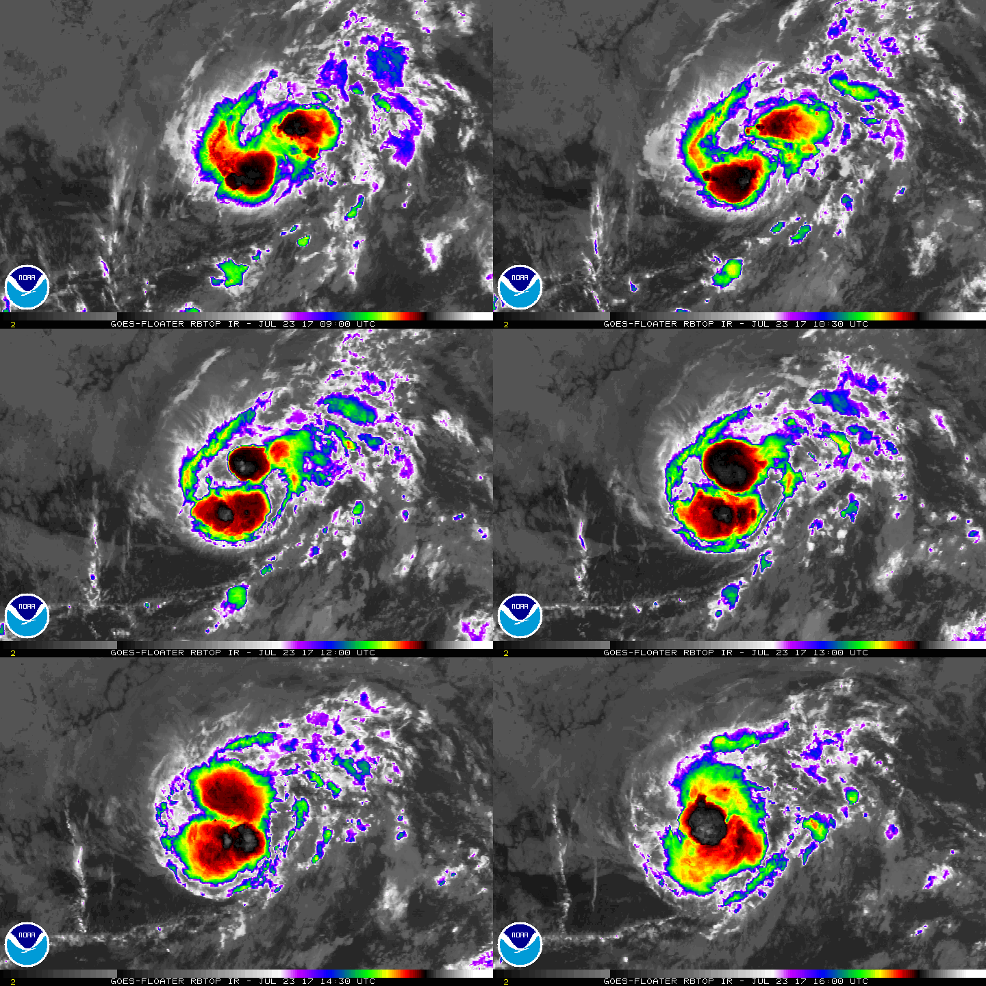
Greg's convective pattern is looking a little better this morning,
with two distinct bursts of thunderstorm activity located near and
to the west of the center.  The latest Dvorak intensity estimates
range from T2.0 to T3.0, and the initial intensity will remain 45
kt since the cyclone's structure has improved somewhat during the
past several hours.

Vertical shear over Greg is less than 10 kt at the moment, but the
cyclone's biggest challenge is dry air in the surrounding
environment.  
GOES-16 lower-level water vapor imagery shows that
Greg is running into a very dry low- to mid-level air mass to its
west, and this environment will likely curtail strengthening.  Greg
is forecast to maintain its intensity for another 24 hours,
followed by gradual weakening due to the dry air, increasing shear,
and cooler sea surface temperatures after 48 hours.
  This scenario
is captured by all of the intensity guidance, and Greg is likely to
degenerate into a remnant low by 96 hours.

A little more southward adjustment of the center location was needed
based on additional ASCAT and other microwave data received since
the last advisory.  Still, low- to mid-level ridging to the north
of Greg is expected to maintain a westward motion through 36 hours.
The ridge is forecast to weaken after 36 hours, which should allow
the cyclone to gain a little more latitude on days 2 through 4.
The low-level trade winds are then expected to push the remnant low
west-southwestward by day 5.  Except for a southward adjustment in
the track forecast to account for the initial position, the model
guidance is in good agreement, and no other significant changes
were required from the previous advisory.

FORECAST POSITIONS AND MAX WINDS

INIT  23/1500Z 14.3N 129.0W   45 KT  50 MPH
12H  24/0000Z 14.3N 130.7W   45 KT  50 MPH
24H  24/1200Z 14.5N 133.0W   45 KT  50 MPH
36H  25/0000Z 14.7N 134.8W   40 KT  45 MPH
48H  25/1200Z 15.0N 136.2W   35 KT  40 MPH
72H  26/1200Z 16.1N 138.6W   30 KT  35 MPH
96H  27/1200Z 16.5N 141.0W   25 KT  30 MPH...POST-TROP/REMNT LOW
120H  28/1200Z 15.9N 143.6W   25 KT  30 MPH...POST-TROP/REMNT LOW

$$
Forecaster Berg
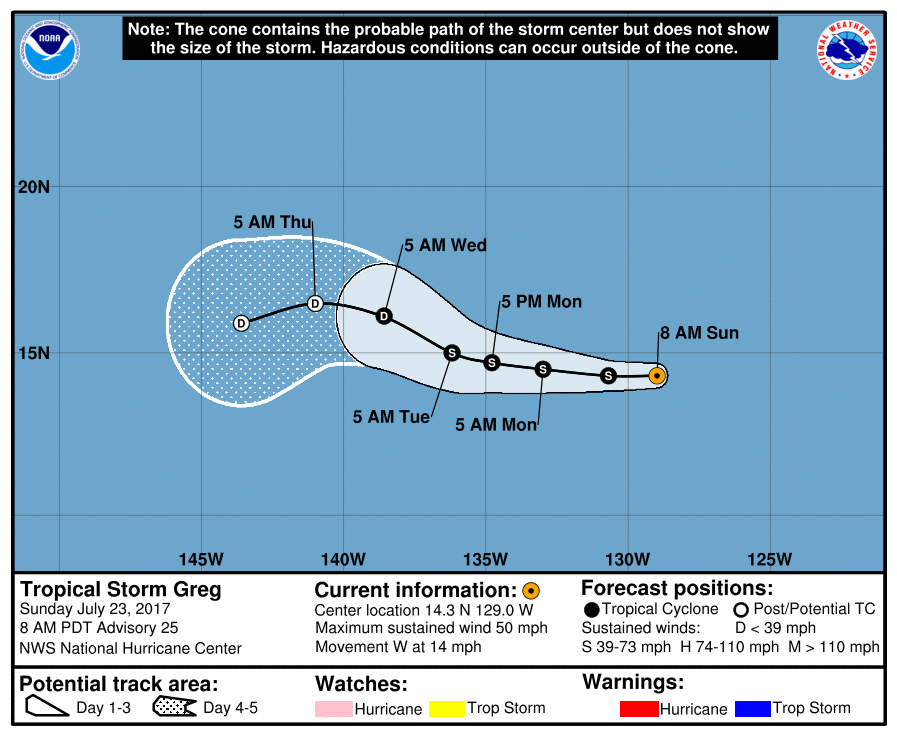
143753_5day_cone_with_line.png

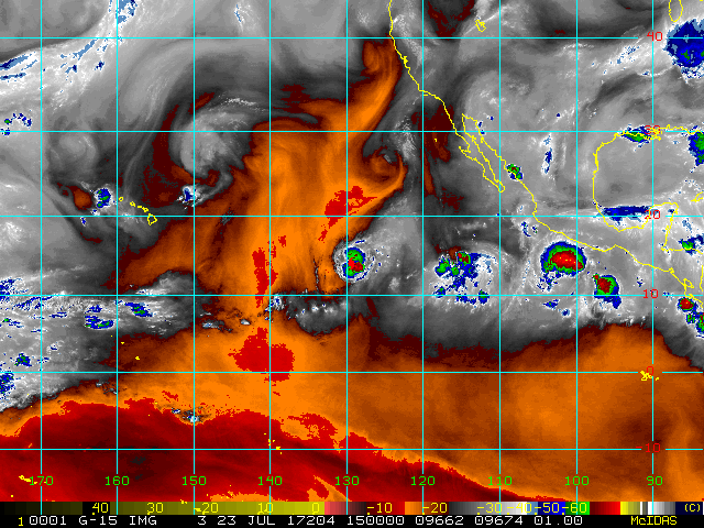
2017EP07_16KMGWVP_201707231500.GIF

rbtop-animated.gif
回復

使用道具 舉報

簽到天數: 3279 天

[LV.Master]伴壇終老

t02436|2017-7-26 21:48 | 顯示全部樓層
昨天21Z就降格TD,現在已經進入中太,15Z轉交CPHC發報。
ZCZC MIATCDEP2 ALL
TTAA00 KNHC DDHHMM

Tropical Depression Greg Discussion Number  36
NWS National Hurricane Center Miami FL       EP072017
200 AM PDT Wed Jul 26 2017

Even with the help of microwave imagery, the center of Greg is
difficult to locate due to the disorganization of the associated
convection. The best estimate is that the center is to the
southeast of the remaining convection.  The initial intensity
remains 30 kt for this advisory, which could be generous.  A
combination of continued southerly to westerly shear, a dry air
mass, and cool sea surface temperatures along the forecast track
should cause the cyclone to stop producing convection and degenerate
to a remnant low in about 24 h.  The low is subsequently expected
to weaken to a trough in 72-96 h.

The initial motion is 305/12.  Low- to mid-level troughing north of
the depression should maintain a northwestward or west-northwestward
motion for the next 12-24 hours.  After that, the remnant low
should turn west-southwestward in the trade winds.  The forecast
track lies near the model consensus and is similar to the previous
advisory.


FORECAST POSITIONS AND MAX WINDS

INIT  26/0900Z 17.8N 139.5W   30 KT  35 MPH
12H  26/1800Z 18.2N 140.6W   30 KT  35 MPH
24H  27/0600Z 18.4N 142.3W   25 KT  30 MPH...POST-TROP/REMNT LOW
36H  27/1800Z 18.3N 144.0W   25 KT  30 MPH...POST-TROP/REMNT LOW
48H  28/0600Z 17.9N 145.6W   20 KT  25 MPH...POST-TROP/REMNT LOW
72H  29/0600Z 17.0N 148.5W   20 KT  25 MPH...POST-TROP/REMNT LOW
96H  30/0600Z...DISSIPATED

$$
Forecaster Beven

NNNN

090056_5day_cone_with_line.png

ZCZC MIATCUEP2 ALL
TTAA00 KNHC DDHHMM

Tropical Depression Greg Tropical Cyclone Update
NWS National Hurricane Center Miami FL       EP072017
625 AM PDT Wed Jul 26 2017

...GREG CROSSES INTO THE CENTRAL PACIFIC...

Satellite imagery indicates that Tropical Depression Greg has
crossed 140W longitude and is now located in the central North
Pacific basin. As a result, the next advisory, which will be issued
at 800 AM PDT/1500 UTC, will use the following central Pacific basin
WMO and AWIPS headers:


Forecast/Advisory: WTPA22 PHFO/HFOTCMCP2
Public Advisory: WTPA32 PHFO/HFOTCPCP2
Tropical Cyclone Discussion: WTPA42 PHFO/HFOTCDCP2

$$
Forecaster Brennan/Avila

NNNN

rbtop_lalo-animated.gif
回復

使用道具 舉報

快速回覆
您需要登錄後才可以回帖 登錄 | 立即加入

本版積分規則

本平台僅供學術討論之用,預報應以氣象局為準

威普網站虛擬主機贊助公司

臺灣第一個天氣類型社群平台 即時天氣資訊、精準颱風動態

線上客服
FB傳送訊息
廣告行銷
精準行銷 物超所值
官方粉專
發佈 快速回復 返回頂部 返回列表