開啟輔助訪問
 找回密碼
 立即加入

15E.Otis 曇花一現 強度大起大落

簽到天數: 2141 天

[LV.Master]伴壇終老

2017-9-11 06:04 | 顯示全部樓層
  三級颶風  
編號:15 E
名稱:Otis

  基本資料  
擾動編號日期:2017 09 11 05
命名日期  :2017 09 17 05
撤編日期  :2017 00 00 00
登陸地點  :暫無

  巔峰時期資料  
近中心最強風速 :100  kt
海平面最低氣壓 :965 毫巴

  過去路徑圖  

  擾動編號資料  
95E.INVEST.20kts-1009mb-16.4N-106.5W

20170910.2145.goes15.x.vis1km_high.95EINVEST.20kts-1009mb-164N-1065W.88pc.jpg

以上資料來自:NHC、台灣颱風論壇整理製作

評分

參與人數 1水氣能量 +15 收起 理由
king111807 + 15

查看全部評分

回復

使用道具 舉報

簽到天數: 601 天

[LV.9]以壇為家II

霧峰追風者|2017-9-12 05:43 | 顯示全部樓層
本帖最後由 霧峰追風者 於 2017-9-12 06:33 編輯

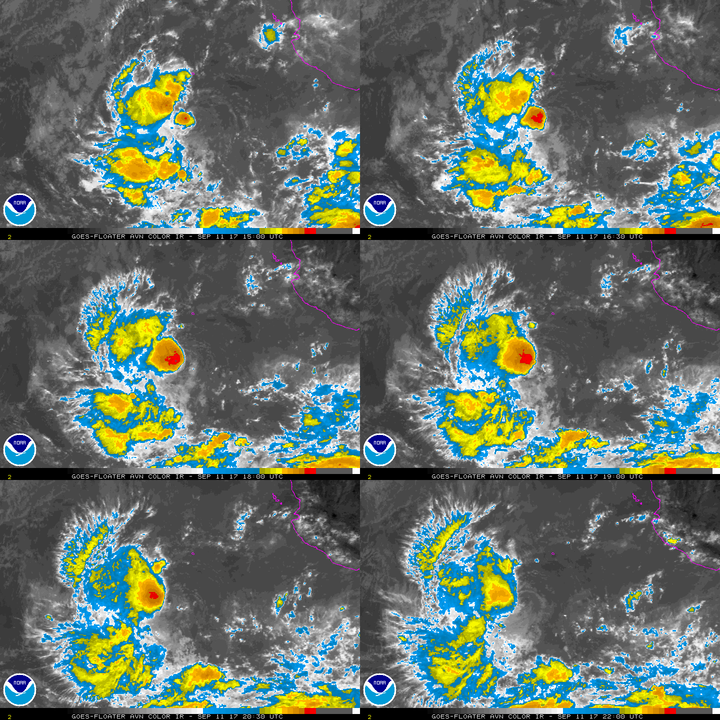
NHC 18Z升格"15E",不看好強度發展,今明兩天還是有機會混個命名機會。
000
WTPZ45 KNHC 112033
TCDEP5

Tropical Depression Fifteen-E Discussion Number   1
NWS National Hurricane Center Miami FL       EP152017
300 PM MDT Mon Sep 11 2017

The remnants of Atlantic Hurricane Katia have redeveloped after
reaching the Pacific Ocean a couple of days ago.  The system
maintained a mid-level circulation while transiting the high terrain
of Mexico, but had lost its surface center.  Yesterday, deep
convection began in association with the mid-level circulation and
today a well-defined surface center formed.  While it was originally
thought that the convection would be sporadic because of the
moderate vertical shear, the deep convection has instead persisted
close to the system's center during the last several hours.  Since
the system now meets the definition of a tropical cyclone,
advisories are initiated as Tropical Depression Fifteen.

The depression is moving toward the west at 13 kt, steered
primarily by the deep-layer ridge to its north.  The official track
forecast is a westward or west-southwestward motion at a slower
rate of forward speed during the next two days, then a turn back
toward the west or west-northwest at days 3 and 4.  This forecast
is based upon a blend of the GFS and ECMWF global models, as the
remaining guidance either doesn't know about the depression or
unrealistically intensifies it and takes it toward the north.

The system likely will not become very substantial.  The moderate
shear should continue, while the depression heads toward cool SSTs
and dry air.  The official intensity forecast shows just modest
strengthening to a low-end tropical storm in about a day, before
weakening begins.  Deep convection may cease in about three days,
marking the system's transition to a remnant low.  The intensity
forecast is based upon the LGEM/DSHIP statistical guidance as the
mesoscale dynamical models spin the depression up to near hurricane
strength, which is not plausible.  If the system does reach
tropical storm intensity - by no means assured, then it
would be named "Max", not "Katia".


FORECAST POSITIONS AND MAX WINDS

INIT  11/2100Z 16.4N 112.3W   25 KT  30 MPH
12H  12/0600Z 16.2N 114.1W   30 KT  35 MPH
24H  12/1800Z 15.8N 116.2W   35 KT  40 MPH
36H  13/0600Z 15.4N 118.0W   30 KT  35 MPH
48H  13/1800Z 15.3N 119.6W   25 KT  30 MPH
72H  14/1800Z 15.7N 121.7W   25 KT  30 MPH...POST-TROP/REMNT LOW
96H  15/1800Z 16.0N 123.5W   20 KT  25 MPH...POST-TROP/REMNT LOW
120H  16/1800Z...DISSIPATED

$$
Forecaster Landsea
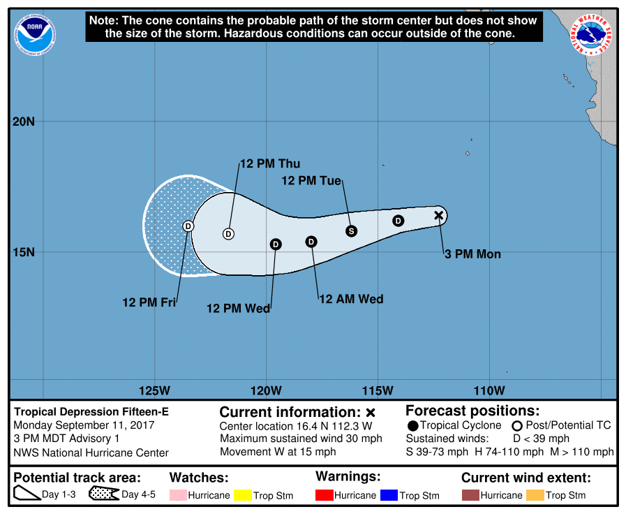
204006_5day_cone_no_line_and_wind.png avn-animated.gif

回復

使用道具 舉報

簽到天數: 2141 天

[LV.Master]伴壇終老

周子堯@FB|2017-9-16 10:52 | 顯示全部樓層
本帖最後由 周子堯@FB 於 2017-9-16 10:58 編輯

預估明天有機會被升格

ZCZC MIATCMEP5 ALLTTAA00 KNHC DDHHMMTROPICAL DEPRESSION FIFTEEN-E FORECAST/ADVISORY NUMBER  18NWS NATIONAL HURRICANE CENTER MIAMI FL       EP1520170300 UTC SAT SEP 16 2017THERE ARE NO COASTAL WATCHES OR WARNINGS IN EFFECT.TROPICAL DEPRESSION CENTER LOCATED NEAR 16.0N 125.4W AT 16/0300ZPOSITION ACCURATE WITHIN  25 NMPRESENT MOVEMENT TOWARD THE WEST OR 270 DEGREES AT   2 KTESTIMATED MINIMUM CENTRAL PRESSURE 1006 MBMAX SUSTAINED WINDS  30 KT WITH GUSTS TO  40 KT.WINDS AND SEAS VARY GREATLY IN EACH QUADRANT.  RADII IN NAUTICALMILES ARE THE LARGEST RADII EXPECTED ANYWHERE IN THAT QUADRANT.REPEAT...CENTER LOCATED NEAR 16.0N 125.4W AT 16/0300ZAT 16/0000Z CENTER WAS LOCATED NEAR 16.0N 125.3WFORECAST VALID 16/1200Z 15.9N 125.7WMAX WIND  30 KT...GUSTS  40 KT.FORECAST VALID 17/0000Z 15.9N 126.0WMAX WIND  35 KT...GUSTS  45 KT.34 KT... 30NE  20SE  20SW  30NW.FORECAST VALID 17/1200Z 16.3N 126.3WMAX WIND  35 KT...GUSTS  45 KT.34 KT... 40NE  30SE  30SW  30NW.FORECAST VALID 18/0000Z 16.8N 126.3WMAX WIND  40 KT...GUSTS  50 KT.34 KT... 40NE  30SE  30SW  30NW.FORECAST VALID 19/0000Z 18.0N 126.3WMAX WIND  40 KT...GUSTS  50 KT.34 KT... 40NE  30SE  30SW  40NW.EXTENDED OUTLOOK. NOTE...ERRORS FOR TRACK HAVE AVERAGED NEAR 100 NMON DAY 4 AND 150 NM ON DAY 5...AND FOR INTENSITY NEAR 15 KT EACH DAYOUTLOOK VALID 20/0000Z 18.5N 127.5WMAX WIND  30 KT...GUSTS  40 KT.OUTLOOK VALID 21/0000Z 18.0N 130.0W...POST-TROP/REMNT LOWMAX WIND  25 KT...GUSTS  35 KT.REQUEST FOR 3 HOURLY SHIP REPORTS WITHIN 300 MILES OF 16.0N 125.4WNEXT ADVISORY AT 16/0900Z$$FORECASTER ZELINSKYNNNN
EP152017_5day_cone_no_line.png

點評

看不懂!只知道白天有機會升格呀!  發表於 2017-9-16 23:56
回復

使用道具 舉報

簽到天數: 601 天

[LV.9]以壇為家II

霧峰追風者|2017-9-17 00:16 | 顯示全部樓層
目前中心在爆對流,看看下報有沒有機會命名。
rbtop-animated (12).gif

回復

使用道具 舉報

簽到天數: 601 天

[LV.9]以壇為家II

霧峰追風者|2017-9-17 05:58 | 顯示全部樓層
NHC 21Z命名"Otis",整合非常長一段時間....
ZCZC MIATCDEP5 ALL
TTAA00 KNHC DDHHMM

Tropical Storm Otis Discussion Number  21
NWS National Hurricane Center Miami FL       EP152017
200 PM PDT Sat Sep 16 2017

The system has been maintaining a small area of deep convection
near the low-level center for the past several hours.  The latest
Dvorak classification from TAFB and ADT values from CIMSS at the
University of Wisconsin have increased, and now support raising the
initial intensity to 35 kt, making the system a tropical storm.

Otis is expected to remain over 27 deg C waters and in a low
wind shear environment for the next couple of days, and this should
allow the cyclone to at least maintain its strength.  Beyond that
time, an increase in shear, drier air, and cooler waters along the
expected track should cause weakening, and Otis is now
forecast to become a remnant low by day 4.  The NHC intensity
forecast is slightly higher than the previous one, based on the
higher initial intensity.

The tropical cyclone continues to drift westward in weak steering
currents.  The models remain in agreement that the storm should
turn slowly northward during the next day or two when it moves
along the west side of a weak mid-level ridge. Once the system
loses convection, a turn back toward the west or west-southwest is
predicted.  The NHC track forecast is a little to the west of the
previous one in the short term to account for the more westward
initial position.

FORECAST POSITIONS AND MAX WINDS

INIT  16/2100Z 15.9N 127.0W   35 KT  40 MPH
12H  17/0600Z 16.0N 127.2W   35 KT  40 MPH
24H  17/1800Z 16.4N 127.3W   35 KT  40 MPH
36H  18/0600Z 17.2N 127.3W   35 KT  40 MPH
48H  18/1800Z 17.9N 127.3W   35 KT  40 MPH
72H  19/1800Z 18.0N 128.3W   30 KT  35 MPH
96H  20/1800Z 17.0N 130.6W   25 KT  30 MPH...POST-TROP/REMNT LOW
120H  21/1800Z 15.8N 133.7W   20 KT  25 MPH...POST-TROP/REMNT LOW

$$
Forecaster Cangialosi


NNNN
204645_5day_cone_no_line_and_wind.png avn-animated (1).gif


回復

使用道具 舉報

簽到天數: 16 天

[LV.4]偶爾看看III

Ryan|2017-9-17 13:30 | 顯示全部樓層
形成颱風機率不告

點評

另外目前強度已達熱帶風暴(輕颱)等級囉  發表於 2017-9-17 14:09
也可以多善用點評功能,比較沒有限制  發表於 2017-9-17 14:09
這裡不是LINE或FB 打錯字可以直接編輯 不要一直發會造成洗版及文章質量低落  發表於 2017-9-17 14:06
回復

使用道具 舉報

簽到天數: 601 天

[LV.9]以壇為家II

霧峰追風者|2017-9-18 07:24 | 顯示全部樓層
超乎預期發展...風眼開啟升二級颶風,巔峰上看三級颶風上限。
ZCZC MIATCDEP5 ALL
TTAA00 KNHC DDHHMM

Hurricane Otis Discussion Number  25
NWS National Hurricane Center Miami FL       EP152017
200 PM PDT Sun Sep 17 2017

Otis continues to surprise us.  Satellite images indicate that the
eye has become more distinct during the past few hours, and the
deep convection is wrapping around that center.  The cyclone is
currently undergoing rapid intensification, and the initial
intensity is increased significantly to 90 kt based on a blend of
the latest satellite estimates.  This makes Otis a category 2
hurricane on the Saffir-Simpson Hurricane Wind Scale.  Even though
Otis is a powerful cyclone, recent ASCAT data confirms that the
wind field of the system is extremely compact.

Some additional strengthening is likely during the next 12 hours
or so while the hurricane remains in an environment of low wind
shear and over 27 deg C waters.  After that time, however, lower
SSTs, drier air, and an increase in wind shear should cause
rapid weakening.  Even though Otis will be moving over warmer waters
by the end of the forecast period, the models continue to show Otis
decaying due to unfavorable atmospheric conditions.  The cyclone is
still forecast to become a remnant low by day 4 based on the global
models, but this is a low confidence prediction at this time.

The hurricane continues to move slowly northward at 4 kt.  A
slow north to north-northwest motion is expected during the next
24 to 36 hours while Otis moves on the west side of a weak mid-level
ridge.  Thereafter, a faster west and west-southwest motion is
expected when the weakening cyclone becomes more influenced by the
low-level tradewind flow.  This track forecast is not too different
from the previous one, and it lies close to the various consensus
aids.

FORECAST POSITIONS AND MAX WINDS

INIT  17/2100Z 17.0N 127.3W   90 KT 105 MPH
12H  18/0600Z 17.7N 127.4W  110 KT 125 MPH
24H  18/1800Z 18.6N 127.6W   90 KT 105 MPH
36H  19/0600Z 19.0N 128.0W   70 KT  80 MPH
48H  19/1800Z 18.8N 128.6W   50 KT  60 MPH
72H  20/1800Z 17.7N 130.7W   35 KT  40 MPH
96H  21/1800Z 16.4N 133.7W   30 KT  35 MPH...POST-TROP/REMNT LOW
120H  22/1800Z 15.0N 136.5W   25 KT  30 MPH...POST-TROP/REMNT LOW

$$
Forecaster Cangialosi

NNNN
205719_5day_cone_no_line_and_wind.png rgb-animated (6).gif rbtop-animated (13).gif


點評

這發展真的有點出乎意料= =  發表於 2017-9-18 10:46
回復

使用道具 舉報

12下一頁
快速回覆
您需要登錄後才可以回帖 登錄 | 立即加入

本版積分規則

本平台僅供學術討論之用,預報應以氣象局為準

威普網站虛擬主機贊助公司

臺灣第一個天氣類型社群平台 即時天氣資訊、精準颱風動態

線上客服
FB傳送訊息
廣告行銷
精準行銷 物超所值
官方粉專
發佈 快速回復 返回頂部 返回列表