開啟輔助訪問
 找回密碼
 立即加入

17E.Norma 環境不佳 逐漸消散

簽到天數: 601 天

[LV.9]以壇為家II

2017-9-14 03:26 | 顯示全部樓層
本帖最後由 霧峰追風者 於 2017-12-12 07:33 編輯

  一級颶風  
編號:17 E
名稱:Norma
800px-Norma_2017-09-15_2055Z.jpg
  基本資料  
擾動編號日期:2017 09 14 03
命名日期  :2017 09 14 21
撤編日期  :2017 09 00 00
登陸地點  :
暫無

  巔峰時期資料  
近中心最強風速
國家颶風中心(NHC):65 kts
海平面最低氣壓:986 毫巴

  過去路徑圖  
17E-Norma.png
  擾動編號資料  

97E-INVEST-25kts-1008mb-15N-110W

20170913.1900.goes-15.ircolor.97E.INVEST.25kts.1008mb.15N.110W.100pc.jpg
NHC : 50%
2. A broad area of low pressure located several hundred miles south of
the southern tip of the Baja California peninsula is producing
disorganized showers and thunderstorms.  Environmental conditions
are expected to be conducive for development of this system, and a
tropical depression is likely to form by the end of the week while
it moves slowly northward.
* Formation chance through 48 hours...medium...50 percent.
* Formation chance through 5 days...high...80 percent.

two_pac_2d2 (1).png

以上資料來自:NHC、颱風論壇整理製作

評分

參與人數 1水氣能量 +15 收起 理由
king111807 + 15

查看全部評分

回復

使用道具 舉報

簽到天數: 601 天

[LV.9]以壇為家II

霧峰追風者|2017-9-14 03:34 | 顯示全部樓層
NHC 18Z展望提升至70%,機構看好發展。
1. A broad area of low pressure is located several hundred miles south
of the southern tip of the Baja California peninsula.  Shower
activity has been gradually increasing in organization, and
conditions are favorable for a tropical depression to form during
the next day or two while the system moves slowly northward.
* Formation chance through 48 hours...high...70 percent.
* Formation chance through 5 days...high...90 percent.
two_pac_2d1 (1).png


回復

使用道具 舉報

簽到天數: 601 天

[LV.9]以壇為家II

霧峰追風者|2017-9-14 21:51 | 顯示全部樓層
本帖最後由 霧峰追風者 於 2017-9-15 02:50 編輯

12Z 直接命名"Norma",編號17E。晚點補NHC報文
20170914.1315.goes-15.ircolor.17E.NORMA.35kts.1004mb.17N.109.5W.095pc (1).jpg rbtop-animated (4).gif

評分

參與人數 1水氣能量 +5 收起 理由
jwpk9899 + 5 最近都這麼搞XD

查看全部評分

回復

使用道具 舉報

簽到天數: 4712 天

[LV.Master]伴壇終老

s6815711|2017-9-15 00:02 | 顯示全部樓層
補個報文
ZCZC MIATCDEP2 ALL
TTAA00 KNHC DDHHMM

Tropical Storm Norma Discussion Number   1
NWS National Hurricane Center Miami FL       EP172017
900 AM MDT Thu Sep 14 2017

The convective structure of the area of disturbed weather well to
the south of the Baja California peninsula has continued to
increase in organization, with an elongated band wrapping around
the southern and eastern sides of the circulation.  Dvorak intensity
estimates have increased to T3.0/45 kt from TAFB and T2.0/30 kt
from SAB, so the system is now classified as a 35-kt tropical storm.

Since Norma has just recently consolidated, its motion is a little
uncertain, but the best estimate is slowly northward, or 360/4 kt.
Norma is located to the northwest of a mid-level ridge that extends
westward from Central America, but it is also due south of a
blocking high centered over northwestern Mexico.  As a result, the
storm is expected to only drift slowly northward for the next 48
hours or so.  After 48 hours, a more pronounced northward motion is
forecast, but there is a lot of spread among the track models
regarding exactly how fast Norma moves north and if it moves east or
west at all.  On the eastern side of the guidance envelope, the GFS
has a weaker ridge over Mexico and a deeper trough off the
California coast, which would cause Norma to turn northeastward
near the southern part of the Baja California peninsula.  On the
western side of the guidance, the ECMWF maintains a stronger ridge,
forcing Norma to turn northwestward to the west of the Baja
California peninsula.  Until the evolving pattern becomes clearer,
the NHC track forecast is between these two extremes and lies
closest to the HFIP Corrected Consensus Approach (HCCA).

Norma is over very warm waters and should remain in a low-shear
environment for at least the next 48-72 hours.  As a result,
steady strengthening is anticipated, and Norma could reach
hurricane strength within about 36 hours.  Strengthening should
continue through 48-72 hours until vertical shear begins to
increase, and a weakening trend is likely to occur on days 4 and 5.
The NHC intensity forecast closely follows the SHIPS guidance and
the ICON intensity consensus, and it is slightly below the HCCA
output.

FORECAST POSITIONS AND MAX WINDS

INIT  14/1500Z 17.2N 109.5W   35 KT  40 MPH
12H  15/0000Z 17.7N 109.5W   45 KT  50 MPH
24H  15/1200Z 18.1N 109.5W   55 KT  65 MPH
36H  16/0000Z 18.4N 109.4W   65 KT  75 MPH
48H  16/1200Z 18.9N 109.4W   75 KT  85 MPH
72H  17/1200Z 21.0N 110.1W   75 KT  85 MPH
96H  18/1200Z 23.5N 111.0W   65 KT  75 MPH
120H  19/1200Z 25.5N 110.5W   55 KT  65 MPH

$$
Forecaster Berg

NNNN
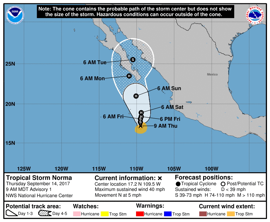
144456_5day_cone_no_line_and_wind.png


回復

使用道具 舉報

簽到天數: 601 天

[LV.9]以壇為家II

霧峰追風者|2017-9-16 12:35 | 顯示全部樓層
NHC 強度升"一級颶風",逐漸北上趨向下加利福尼亞半島。
ZCZC MIATCDEP2 ALL
TTAA00 KNHC DDHHMM

Hurricane Norma Discussion Number   7
NWS National Hurricane Center Miami FL       EP172017
900 PM MDT Fri Sep 15 2017

Infrared satellite imagery indicates that banding associated with
Norma has increased during the past few hours.  The convective cloud
tops have cooled and the band surrounding the center has become a
little more solid with the formation of a ragged banding eye. Dvorak
data T-numbers from both TAFB and SAB are 4.0, and with the recent
increase in organization the initial wind speed is increased to 65
kt. Norma becomes the eighth hurricane in the eastern Pacific this
season.

Norma should remain over warm water and within a low shear
environment during the next 24 to 36 h.  These conditions favor
strengthening, but the large size of Norma is likely to keep the
intensification rate in check.  Increasing vertical shear and cooler
waters are expected to impart gradual weakening after 48 hours.  The
latest NHC intensity forecast is similar to the previous advisory
and is close to the SHIPS guidance.

Norma has been moving slowly north-northwestward, with an initial
motion estimate of 335/2 kt.  The hurricane is forecast to move
slowly northward during the next couple of days, while it remains
along the western side of a mid-level ridge.  After that time, the
ECMWF develops a narrow ridge to the north of Norma which causes the
hurricane to turn northwestward.  Meanwhile, the GFS keeps Norma on
a north track over the Baja California peninsula. The trend of the
track guidance has been westward during the past several cycles, so
the NHC forecast lies slightly west of the consensus, and closer to
the ECMWF that has been more consistent over the past few runs.
Given the large spread in the guidance later in the period, the
confidence in the track forecast after 48 hours remains low.

The 48-hour forecast track and wind radii are very close to the
southern tip of the Baja California peninsula.  However, with the
persistent westward shifts in the guidance, a tropical storm watch
does not appear to be needed at this time.  We will assess future
model trends for the possibility of a watch issuance later tonight
or tomorrow.


FORECAST POSITIONS AND MAX WINDS

INIT  16/0300Z 19.0N 110.2W   65 KT  75 MPH
12H  16/1200Z 19.3N 110.4W   70 KT  80 MPH
24H  17/0000Z 20.0N 110.5W   75 KT  85 MPH
36H  17/1200Z 21.0N 110.9W   75 KT  85 MPH
48H  18/0000Z 22.0N 111.3W   70 KT  80 MPH
72H  19/0000Z 23.7N 112.3W   60 KT  70 MPH
96H  20/0000Z 24.6N 112.6W   45 KT  50 MPH
120H  21/0000Z 25.5N 111.5W   30 KT  35 MPH...INLAND

$$
Forecaster Brown


NNNN
030215_5day_cone_no_line_and_wind.png rbtop-animated (9).gif


回復

使用道具 舉報

簽到天數: 601 天

[LV.9]以壇為家II

霧峰追風者|2017-9-20 13:12 | 顯示全部樓層
NHC 發出最後一報,最後對陸地沒有造成威脅,逐漸消散。
000
WTPZ42 KNHC 200232
TCDEP2

Post-Tropical Cyclone Norma Discussion Number  23
NWS National Hurricane Center Miami FL       EP172017
800 PM PDT Tue Sep 19 2017

All that is left of Norma is a skeletal low-level circulation and
some cirrus debris clouds.  Organized deep convection has been gone
for quite some time, so this will be the last advisory.  The
remnant low is forecast to gradually turn northwest and north and
weaken over colder water.

For additional information on the remnant low please see High Seas
Forecasts issued by the National Weather Service, under AWIPS
header NFDHSFEPI, WMO header FZPN02 KWBC, and on the web at
http://www.opc.ncep.noaa.gov/shtml/NFDHSFEPI.shtml.

FORECAST POSITIONS AND MAX WINDS

INIT  20/0300Z 22.1N 115.6W   30 KT  35 MPH...POST-TROP/REMNT LOW
12H  20/1200Z 22.4N 116.3W   25 KT  30 MPH...POST-TROP/REMNT LOW
24H  21/0000Z 22.8N 116.8W   20 KT  25 MPH...POST-TROP/REMNT LOW
36H  21/1200Z 23.5N 117.0W   20 KT  25 MPH...POST-TROP/REMNT LOW
48H  22/0000Z...DISSIPATED

$$
Forecaster Blake
023619_5day_cone_no_line_and_wind.png rgb-animated (8).gif


回復

使用道具 舉報

快速回覆
您需要登錄後才可以回帖 登錄 | 立即加入

本版積分規則

本平台僅供學術討論之用,預報應以氣象局為準

威普網站虛擬主機贊助公司

臺灣第一個天氣類型社群平台 即時天氣資訊、精準颱風動態

線上客服
FB傳送訊息
廣告行銷
精準行銷 物超所值
官方粉專
發佈 快速回復 返回頂部 返回列表