開啟輔助訪問
 找回密碼
 立即加入

18E.Pilar 登陸墨西哥 逐漸消散

簽到天數: 601 天

[LV.9]以壇為家II

2017-9-21 19:36 | 顯示全部樓層
本帖最後由 霧峰追風者 於 2017-12-12 07:31 編輯

  熱帶風暴  
編號:18 E
名稱:Pilar
800px-Pilar_2017-09-24_1740Z.jpg
  基本資料  
擾動編號日期:2017 09 21 19
命名日期  :2017 09 24 08
撤編日期  :2017 09 26 12
登陸地點  :墨西哥 席娜羅亞州 馬薩特蘭

  巔峰時期資料  
近中心最強風速
國家颶風中心(NHC):40 kts
海平面最低氣壓:1001 毫巴

  過去路徑圖  
18E-Pilar.png
  擾動編號資料  
98E-INVEST-20kts-1007mb-17.5N-103E

20170921.1130.goes13.x.ir1km_bw.98EINVEST.20kts-1008mb-175N-1030W.99pc.jpg

NHC:60%
1. Shower and thunderstorm activity associated with a broad area of low
pressure located just offshore of the southwest coast of Mexico
has increased, but remains disorganized.  Environmental conditions
are expected to be conducive for gradual development, and a tropical
depression is likely to form in two to three days as the system
moves slowly toward the west-northwest.  Regardless of tropical
cyclone formation, heavy rains are expected over portions of
southern Mexico during the next several days.
* Formation chance through 48 hours...medium...60 percent.
* Formation chance through 5 days...high...80 percent.

two_pac_2d1.png

以上資料來自:NHC、颱風論壇整理製作

評分

參與人數 1水氣能量 +15 收起 理由
t02436 + 15

查看全部評分

回復

使用道具 舉報

簽到天數: 601 天

[LV.9]以壇為家II

霧峰追風者|2017-9-22 02:45 | 顯示全部樓層
NHC 展望提升至70%,墨西哥西南方近岸整合發展。
1. Shower and thunderstorm activity associated with a broad area of low
pressure located just offshore of the southwestern coast of Mexico
is beginning to show some signs of organization.  Environmental
conditions are expected to be conducive for gradual development,
and a tropical depression is likely to form during the next couple
of days as the system drifts west-northwestward to westward.
Regardless of tropical cyclone formation, heavy rains are expected
over portions of southwestern Mexico during the next several days.
* Formation chance through 48 hours...high...70 percent.
* Formation chance through 5 days...high...90 percent.
two_pac_2d1 (2).png


回復

使用道具 舉報

簽到天數: 971 天

[LV.10]以壇為家III

jwpk9899|2017-9-22 08:55 | 顯示全部樓層
JTWC 00z發布TCFA

WTPN21 PHNC 212200MSGID/GENADMIN/JOINT TYPHOON WRNCEN PEARL HARBOR HI//SUBJ/TROPICAL CYCLONE FORMATION ALERT//RMKS/1. FORMATION OF A SIGNIFICANT TROPICAL CYCLONE IS POSSIBLE WITHIN190 NM EITHER SIDE OF A LINE FROM 16.7N 101.2W TO 21.0N 109.4WWITHIN THE NEXT 12 TO 24 HOURS. AVAILABLE DATA DOES NOT JUSTIFYISSUANCE OF NUMBERED TROPICAL CYCLONE WARNINGS AT THIS TIME.WINDS IN THE AREA ARE ESTIMATED TO BE 18 TO 23 KNOTS. METSATIMAGERY AT 211800Z INDICATES THAT A CIRCULATION CENTER IS LOCATEDNEAR 18.0N 104.2W. THE SYSTEM IS MOVING WEST-NORTHWESTWARD AT 13KNOTS.2. REMARKS: AN AREA OF CONVECTION (INVEST 98E) HAS PERSISTED NEAR 18N104.2E, APPROXIMATELY 1130 NM SOUTHEAST OF SAN DIEGO, CA. ANIMATEDENHANCED INFRARED SATELLITE IMAGERY SHOWS A BROAD AREA OF CIRCULATIONASSOCIATED WITH FLARING CONVECTION. LOW LEVEL VORTICITY HAS BECOMEMORE ORGANIZED BUT REMAINS ELONGATED. VERTICAL WIND SHEAR ISFAVORABLE (5-10 KNOTS) FOR DEVELOPMENT. POLEWARD OUTFLOW REMAINS WEAKWHILE EQUATORWARD OUTFLOW IS MODERATELY FAVORABLE. SEA SURFACETEMPERATURES (30-32 CELSIUS) ARE FAVORABLE FOR DEVELOPMENT. NUMERICALMODELS SHOW CONTINUED DEVELOPMENT OF THIS CIRCULATION AS IT TRAVELSTO THE WEST-NORTHWEST. MAXIMUM SUSTAINED SURFACE WINDS ARE ESTIMATEDAT 18 TO 23 KNOTS. MINIMUM SEA LEVEL PRESSURE IS ESTIMATED TO BE NEAR1005 MB. THE POTENTIAL FOR THE DEVELOPMENT OF A SIGNIFICANT TROPICALCYCLONE WITHIN THE NEXT 24 HOURS IS HIGH.3. THIS ALERT WILL BE REISSUED, UPGRADED TO WARNING OR CANCELLED BY222200Z.//NNNN ep9817.gif

回復

使用道具 舉報

簽到天數: 601 天

[LV.9]以壇為家II

霧峰追風者|2017-9-24 08:55 | 顯示全部樓層
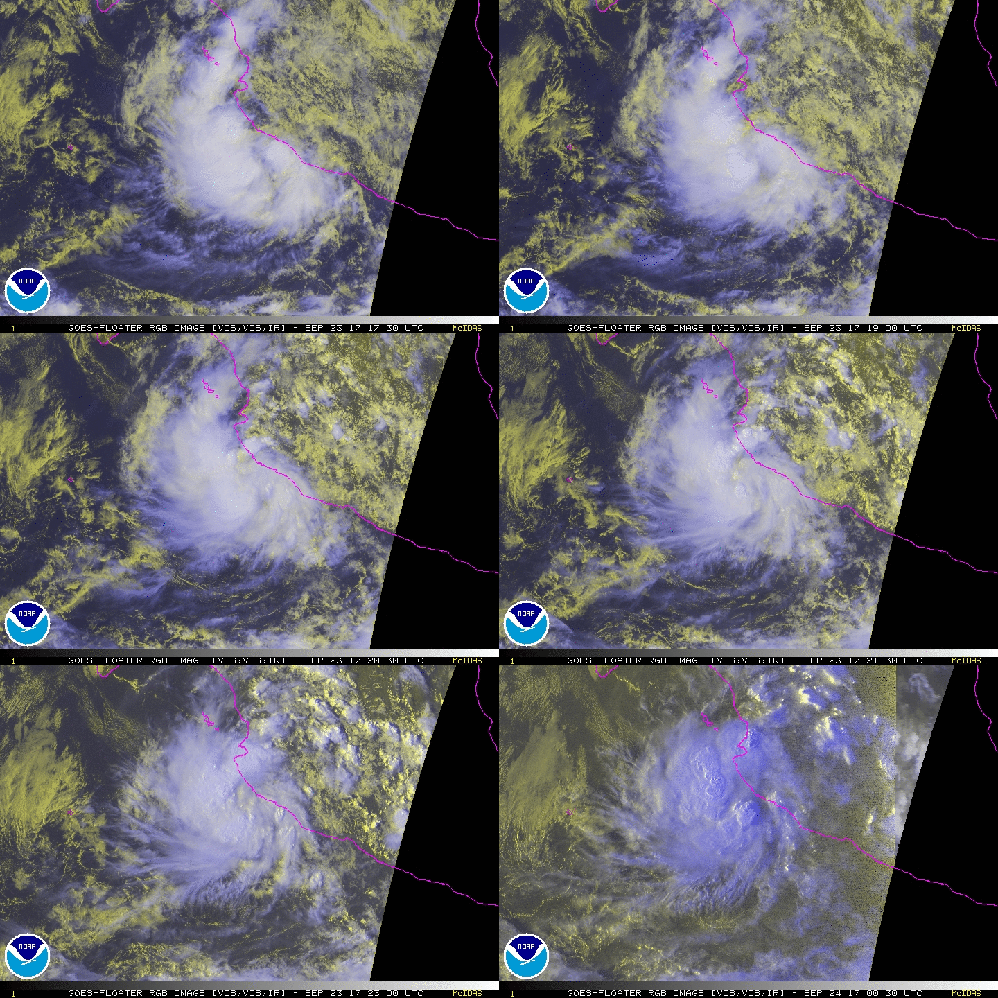
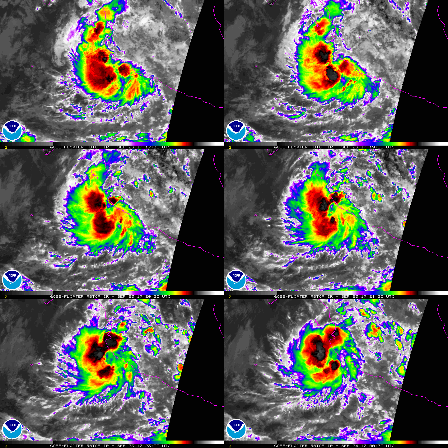
21Z升格"18E",預計貼著莫西個近岸北上,巔峰預估50KT。
000
WTPZ43 KNHC 232042
TCDEP3

Tropical Depression Eighteen-E Discussion Number   1
NWS National Hurricane Center Miami FL       EP182017
400 PM CDT Sat Sep 23 2017

ASCAT-A/-B scatterometer data from around 16-17Z indicated that the
low pressure system located just offshore of the southwestern coast
of Mexico that the NHC has been tracking the past several days has
become much better defined, and it also possessed surface winds of
30-33 kt. As a result, the system has been upgraded to a tropical
depression, the eighteenth of the eastern Pacific hurricane season.

The initial motion estimate is 335/04, based primarily on microwave
satellite fixes. The latest NHC model guidance is in fairly good
agreement on the cyclone moving slowly in a general
north-northwestward direction around the western periphery of a
deep-layer ridge for the next 5 days. Some of the models like the
GFS, Canadian, and HCCA take the system just inland near Cabo
Corrientes in about 24 hours, whereas the remainder of the guidance,
especially the UKMET and ECMWF, keep the cyclone just offshore of
the southwestern coast of Mexico. The forecast motion for the next
few days is expected to be 5 kt or less, an indication that steering
currents will be weak. Since there is no strong forcing that would
want to drive the depression inland over the mountainous terrain of
southwestern Mexico, the official forecast calls for the center of
the cyclone to remain just offshore of the coast throughout the
forecast period, similar to the ECMWF and UKMET solutions.

Given the well-defined circulation noted in the aforementioned
scatterometer data, along with vertical wind shear decreasing to
less than 10 kt by 24 hours, steady strengthening is forecast for
the next 24-36 hours. Afterwards, southeasterly to southerly shear
is expected to gradually increase to 25 kt by 72 hours and more
than 30 kt in the 96-120 hour period, which should induce steady to
possible rapid weakening. The NHC intensity forecast is above most
of the guidance through 48 hours, and then is a little lower than
the guidance after that.

Due to the depression being forecast to become a tropical storm by
tonight, along with its proximity to the coast of Mexico, a tropical
storm warning has been issued from Manzanillo northward to El
Roblito, including the Islas Marias. Heavy rainfall causing flash
floods and mudslides will also be possible within the warning area
and extending well inland.

FORECAST POSITIONS AND MAX WINDS

INIT  23/2100Z 18.4N 105.3W   30 KT  35 MPH
12H  24/0600Z 18.8N 105.5W   40 KT  45 MPH
24H  24/1800Z 19.4N 105.7W   50 KT  60 MPH
36H  25/0600Z 20.2N 106.0W   50 KT  60 MPH
48H  25/1800Z 21.2N 106.2W   45 KT  50 MPH
72H  26/1800Z 22.7N 107.0W   40 KT  45 MPH
96H  27/1800Z 24.0N 108.4W   35 KT  40 MPH...POST-TROPICAL
120H  28/1800Z 26.0N 110.0W   30 KT  35 MPH...POST-TROP/REMNT LOW

$$
Forecaster Stewart
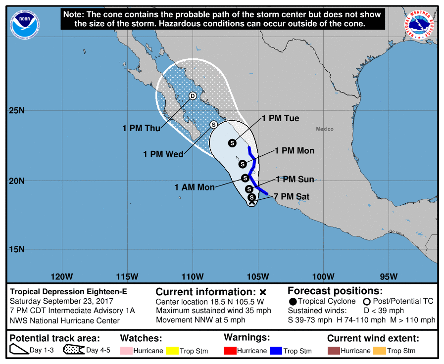
233153_5day_cone_no_line_and_wind.png rgb-animated (10).gif rbtop-animated (17).gif


回復

使用道具 舉報

簽到天數: 3291 天

[LV.Master]伴壇終老

t02436|2017-9-24 11:05 | 顯示全部樓層
命名Pilar,或許一生將巧妙避開所有陸地:o
ZCZC MIATCDEP3 ALL
TTAA00 KNHC DDHHMM

Tropical Storm Pilar Discussion Number   2
NWS National Hurricane Center Miami FL       EP182017
1000 PM CDT Sat Sep 23 2017

The structure of the cyclone near Mexico has improved over the past
6 hours.  Dvorak intensity estimates from TAFB and SAB now support
an estimated intensity of 35 kt, so the system is now classified as
Tropical Storm Pilar.

The initial motion based on recent satellite fixes is 350/4 kt.
Pilar is still expected to move generally toward the north-northwest
or north to the east of a mid-level ridge centered over Mexico for
the next couple of days, and the primary source of uncertainty in
the forecast is possible interaction with land.  Due in part to
initial position uncertainty, the global models vary on whether
Pilar will clip the coast of Jalisco or remain just offshore, but
the model consensus now shows a landfall in about 24 hours.  The
NHC forecast has been adjusted slightly to the east toward the
model consensus, but it is certainly possible that the tropical
storm could remain offshore and enter the Gulf of California.
Regardless of whether the center makes landfall or not, heavy rain
is still likely along the coast of Mexico through early next week.

The possibility of land interaction makes the intensity forecast
particularly difficult.  Very warm SSTs and only moderate shear
should allow for some strengthening for at least the next 36 hours.
However, if Pilar makes landfall sooner than that, it will likely
quickly weaken.  Since my track forecast shows Pilar making
landfall in about 24 hours, my intensity forecast peaks at that
time, and shows steady weakening thereafter.  Beginning around 48
h, the GFS and ECMWF show that the shear will increase
substantially, which should cause Pilar to quickly become a remnant
low, even if it remains over water.


FORECAST POSITIONS AND MAX WINDS

INIT  24/0300Z 18.7N 105.3W   35 KT  40 MPH
12H  24/1200Z 19.3N 105.5W   45 KT  50 MPH
24H  25/0000Z 20.3N 105.6W   50 KT  60 MPH
36H  25/1200Z 21.1N 105.7W   45 KT  50 MPH
48H  26/0000Z 21.9N 105.9W   40 KT  45 MPH
72H  27/0000Z 23.3N 106.4W   30 KT  35 MPH...POST-TROP/REMNT LOW
96H  28/0000Z 24.7N 107.3W   25 KT  30 MPH...POST-TROP/REMNT LOW
120H  29/0000Z...DISSIPATED

$$
Forecaster Zelinsky

NNNN

233153_5day_cone_with_line.png

GOES024520172677Y6vFG.jpg
回復

使用道具 舉報

簽到天數: 3291 天

[LV.Master]伴壇終老

t02436|2017-9-25 14:34 | 顯示全部樓層
最新報改登陸,但將會是以熱帶低壓的強度登陸。
000
WTPZ43 KNHC 250231
TCDEP3

Tropical Storm Pilar Discussion Number   6
NWS National Hurricane Center Miami FL       EP182017
900 PM MDT Sun Sep 24 2017

Satellite images suggest that Pilar is maintaining its strength
this evening.  The center of the system is difficult to locate, but
extrapolation of earlier microwave data and current geostationary
images suggest that it is located just to the north of Las Islas
Marias.  The initial intensity is held at 35 kt, though some
of the latest satellite intensity estimates suggest that this could
be a little conservative.

Pilar is very close to the coast, and the models either show the
tropical cyclone moving inland or staying just off the coast of
western Mexico.  This land interaction combined with an increase in
south-southwesterly shear should cause the storm to weaken to a
tropical depression on Monday, and dissipate in a couple of days or
less.  It should be noted that if Pilar does move inland, it could
dissipate sooner than shown here.

A long term motion has been northward at 8 kt.  A slower north to
north-northwest motion in the low- to mid-level flow is expected
until the system dissipates.  This track forecast lies closest to
the ECMWF and UKMET models.

The main hazard associated with Pilar is the potential for heavy
rainfall, which could cause life-threatening flash floods and
mudslides, over the states of Nayarit and the southern portion of
Sinaloa during the next day or two.

FORECAST POSITIONS AND MAX WINDS

INIT  25/0300Z 21.8N 106.3W   35 KT  40 MPH
12H  25/1200Z 22.6N 106.5W   35 KT  40 MPH
24H  26/0000Z 23.4N 106.7W   30 KT  35 MPH
36H  26/1200Z 24.0N 107.1W   25 KT  30 MPH
48H  27/0000Z...DISSIPATED

$$
Forecaster Cangialosi

053747_5day_cone_with_line_and_wind.png

LATEST.jpg

GOES06152017268oMKq3b.jpg

rbtop-animated.gif
回復

使用道具 舉報

簽到天數: 601 天

[LV.9]以壇為家II

霧峰追風者|2017-9-26 06:40 | 顯示全部樓層
稍早中心登陸,逐漸消散。
000
WTPZ43 KNHC 252034
TCDEP3

Remnants Of Pilar Discussion Number   9
NWS National Hurricane Center Miami FL       EP182017
300 PM MDT Mon Sep 25 2017

GOES-16 visible imagery along with ASCAT scatterometer data
indicate that Pilar has degenerated into a trough of low pressure
extending from the southern tip of the Baja California peninsula and
the coast of western Mexico.  This is the last advisory issued on
Pilar.  The highest winds remaining in association with Pilar's
remnants are 20 kt, as observed by the scatterometer.

Some deep convection remains in association with the remnants of
Pilar along the coast of western Mexico and inland.  The main hazard
associated with the remnants of Pilar will be heavy rainfall, which
could trigger life-threatening flash floods and mudslides over the
states of northern Nayarit, the southern portion of Sinaloa, and the
southwestern portion of Durango during the next day or so.


FORECAST POSITIONS AND MAX WINDS

INIT  25/2100Z 23.8N 107.1W   20 KT  25 MPH...REMNANTS
12H  26/0600Z...DISSIPATED

$$
Forecaster Landsea
203954_5day_cone_no_line_and_wind.png rgb-animated (12).gif

回復

使用道具 舉報

快速回覆
您需要登錄後才可以回帖 登錄 | 立即加入

本版積分規則

本平台僅供學術討論之用,預報應以氣象局為準

威普網站虛擬主機贊助公司

臺灣第一個天氣類型社群平台 即時天氣資訊、精準颱風動態

線上客服
FB傳送訊息
廣告行銷
精準行銷 物超所值
官方粉專
發佈 快速回復 返回頂部 返回列表