開啟輔助訪問
 找回密碼
 立即加入

02S.Hilda 近岸命名快速增強 登澳首旋

簽到天數: 601 天

[LV.9]以壇為家II

2017-12-22 21:41 | 顯示全部樓層
本帖最後由 霧峰追風者 於 2018-3-27 15:05 編輯

  二級熱帶氣旋  
編號:06 U ( 02 S )
名稱:Hilda
Hilda_2017-12-28_0215Z.jpg
  基本資料  
擾動編號日期:2017 12 22 21
升格熱低日期:2017 12 26 08
命名日期  :2017 12 27 18
撤編日期  :2018 01 01 12
登陸地點  :澳洲 西澳大利亞洲 布魯姆市

  巔峰時期資料  
澳洲氣象局 (BoM):50 kt
聯合颱風警報中心 (JTWC):40 kts ( TS )
海平面最低氣壓:985 百帕

  過去路徑圖  
1920px-Hilda_2017_track.png
  擾動編號資料  

92S.INVEST.15kts.1010mb.7.4S.122.1E

20171222.0645.f15.37h.92S.INVEST.15kts.1010mb.7.4S.122.1E.085pc.jpg

以上資料來自:BoM、JTWC、颱風論壇整理製作


評分

參與人數 1水氣能量 +15 收起 理由
s6815711 + 15

查看全部評分

回復

使用道具 舉報

簽到天數: 601 天

[LV.9]以壇為家II

霧峰追風者|2017-12-26 02:52 | 顯示全部樓層
本帖最後由 霧峰追風者 於 2017-12-28 06:48 編輯

JTWC 17Z評級Low
(1) AN AREA OF CONVECTION (INVEST 92S) HAS PERSISTED NEAR
13.5S 125.4E, APPROXIMATELY 830 NM NORTHEAST OF LEARMONTH,
AUSTRALIA. ANIMATED ENHANCED INFRARED SATELLITE IMAGERY AND A
251327Z 89GHZ AMSU-B MICROWAVE IMAGE DEPICT A VERY WEAK AND BROAD
CIRCULATION WITH PERSISTENT CONVECTION. THE DISTURBANCE IS CURRENTLY
LOCATED IN AN AREA OF GOOD EQUATORWARD OUTFLOW, LOW TO MODERATE (15-
20 KNOTS) VERTICAL WIND SHEAR, AND VERY WARM SEA SURFACE
TEMPERATURES (30-32 CELSIUS). GLOBAL MODELS INDICATE THAT THE
DISTURBANCE WILL TRACK TO THE SOUTHWEST OVER THE NEXT SEVERAL DAYS,
BUT DO NOT AGREE ON THE EXTENT OR TIMING OF CONSOLIDATION, WITH
NAVGEM BEING THE MOST AGGRESSIVE AND INTENSIFYING TO STORM STRENGTH
AT AROUND TAU 120. MAXIMUM SUSTAINED SURFACE WINDS ARE ESTIMATED AT
15 TO 20 KNOTS. MINIMUM SEA LEVEL PRESSURE IS ESTIMATED TO BE NEAR
1004 MB. THE POTENTIAL FOR THE DEVELOPMENT OF A SIGNIFICANT TROPICAL
CYCLONE WITHIN THE NEXT 24 HOURS IS LOW.

abiosair.jpg 20171225.1820.himawari-8.ircolor.92S.INVEST.20kts.1004mb.13.9S.125.2E.100pc.jpg


回復

使用道具 舉報

簽到天數: 1765 天

[LV.Master]伴壇終老

zjk369|2017-12-26 11:16 | 顯示全部樓層
已發布MEDIUM abpwsair 201712260200.jpg

回復

使用道具 舉報

簽到天數: 601 天

[LV.9]以壇為家II

霧峰追風者|2017-12-26 13:01 | 顯示全部樓層
BoM 升格帶熱低壓,並開始發報,有機會在登陸前命名,巔峰暫時上望澳式C2。
TROPICAL CYCLONE ADVICE NUMBER 1
Issued at 8:50 am WST on Tuesday 26 December 2017

Headline:
Developing tropical low may bring gales to the west Kimberley coast from as early as Wednesday night.

Areas Affected:
Warning Zone
None.

Watch Zone
Beagle Bay to Whim Creek, including Broome and Port Hedland.

Cancelled Zone
None.

Details of Tropical Low at 8:00 am AWST:
Intensity: Tropical Low, sustained winds near the centre of 35 kilometres per hour with wind gusts to 85 kilometres per hour.

Location: within 165 kilometres of 14.1 degrees South 122.5 degrees East, estimated to be 430 kilometres north of Broome and 375 kilometres north northwest of Derby.

Movement: slow moving.

A low is developing off the west Kimberley coast. The low is likely to form into a tropical cyclone later on Wednesday as it moves towards the south southwest.

Hazards:
Gales may occur along the coast from Beagle Bay to Broome as early as Wednesday evening, or more likely on Thursday morning. Gales may extend down the coast during Thursday as the system approaches the east Pilbara coast. Gales are possible at Port Hedland on Thursday night if the system takes a more westerly track.

Recommended Action:
DFES advises of the following community alerts:

BLUE ALERT: People in or near Cape Leveque to Wallal need to prepare for cyclonic weather and organise an emergency kit including first aid kit, torch, portable radio, spare batteries, food and water.

Next Advice:
The next advice will be issued by 3:00 pm AWST Tuesday 26 December.

Cyclone advices and DFES Alerts are available by dialling 13 DFES (13 3337)
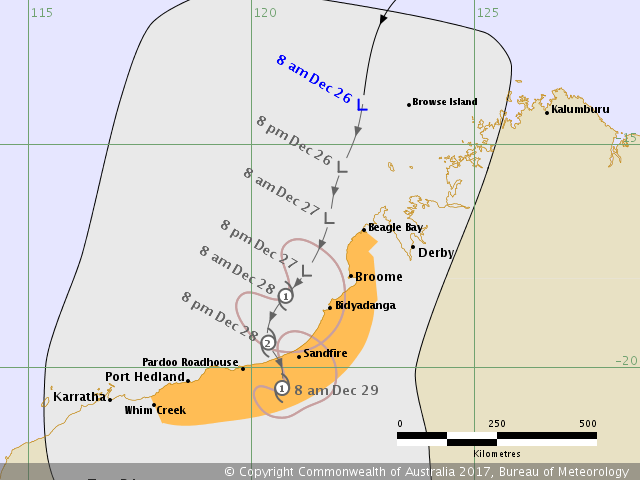
IDW60280.png

Details:
         Time (AWST)        Intensity Category        Latitude
(decimal deg.)        Longitude
(decimal deg.)        Estimated Position
Accuracy (km)
0hr        8 am December 26        tropical low        14.1S        122.5E        165
+6hr        2 pm December 26        tropical low        14.8S        122.3E        425
+12hr        8 pm December 26        tropical low        15.5S        122.1E        400
+18hr        2 am December 27        tropical low        16.0S        121.9E        275
+24hr        8 am December 27        tropical low        16.6S        121.8E        225
+36hr        8 pm December 27        tropical low        17.8S        121.3E        240
+48hr        8 am December 28        1        18.4S        120.8E        225
+60hr        8 pm December 28        2        19.4S        120.4E        210
+72hr        8 am December 29        1        20.5S        120.7E        350
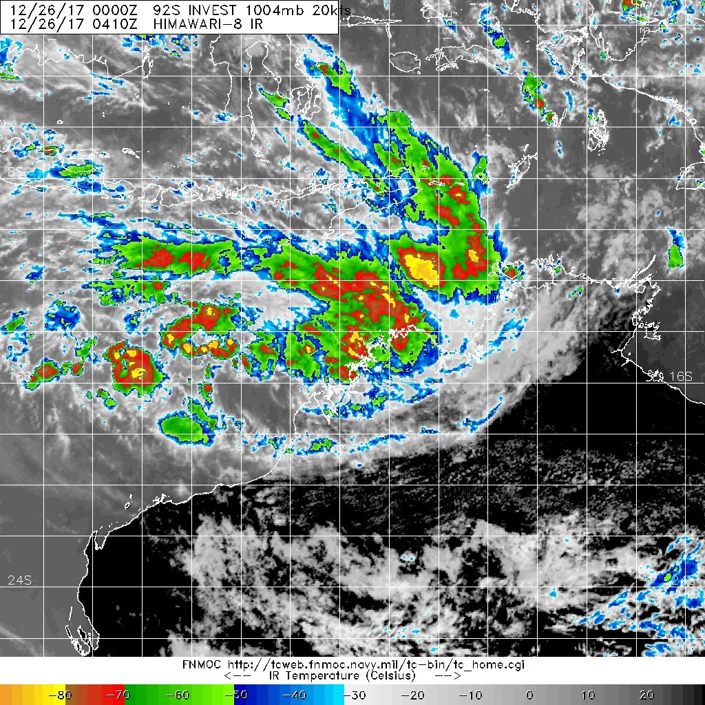
20171226.0410.himawari-8.ircolor.92S.INVEST.20kts.1004mb.14.8S.124.5E.100pc.jpg


回復

使用道具 舉報

簽到天數: 601 天

[LV.9]以壇為家II

霧峰追風者|2017-12-27 12:11 | 顯示全部樓層
JTWC 23Z發佈TCFA
WTXS21 PGTW 262300
MSGID/GENADMIN/JOINT TYPHOON WRNCEN PEARL HARBOR HI//
SUBJ/TROPICAL CYCLONE FORMATION ALERT//
RMKS/
1. FORMATION OF A SIGNIFICANT TROPICAL CYCLONE IS POSSIBLE WITHIN
155 NM EITHER SIDE OF A LINE FROM 15.5S 123.3E TO 19.8S 119.2E
WITHIN THE NEXT 12 TO 24 HOURS. AVAILABLE DATA DOES NOT JUSTIFY
ISSUANCE OF NUMBERED TROPICAL CYCLONE WARNINGS AT THIS TIME.
WINDS IN THE AREA ARE ESTIMATED TO BE 28 TO 33 KNOTS. METSAT
IMAGERY AT 261200Z INDICATES THAT A CIRCULATION CENTER IS LOCATED
NEAR 15.7S 123.2E. THE SYSTEM IS MOVING SOUTHWARD AT 06 KNOTS.
2. REMARKS: THE AREA OF CONVECTION PREVIOUSLY LOCATED NEAR 16.5S
122.4E IS NOW LOCATED NEAR 15.7S 123.2E, APPROXIMATELY 645 NM
NORTHEAST OF LEARMONTH, AUSTRALIA. ANIMATED MULTISPECTRAL SATELLITE
IMAGERY DEPICTS A CONSOLIDATING LOW-LEVEL CIRCULATION CENTER (LLCC)
WITH FORMATIVE BANDING OVER THE NORTHERN SEMI-CIRCLE. A 261135Z AMSU
89GHZ IMAGE SHOWS CURVED, DEEP BANDING OVER THE NORTHERN PERIPHERY
WRAPPING INTO A LLCC IN THE SOUTHWESTERN QUADRANT OF THE LLCC. A
261307Z ASCAT PASS SHOWS AN AREA OF 25-30 KNOT WINDS LOCATED IN THE
NORTHWESTERN QUADRANT. THE UPPER LEVEL ANALYSIS REVEALS A FAVORABLE
ENVIRONMENT WITH LOW TO MODERATE (10-15 KNOTS) VERTICAL WIND SHEAR
AND RADIAL OUTFLOW. DYNAMIC MODELS INDICATE GRADUAL INTENSIFICATION
OVER THE 24-36 HRS AS THE SYSTEM TRACKS TO THE SOUTHWEST. MAXIMUM
SUSTAINED SURFACE WINDS ARE ESTIMATED AT 28 TO 33 KNOTS. MINIMUM SEA
LEVEL PRESSURE IS ESTIMATED TO BE NEAR 998 MB. THE POTENTIAL FOR THE
DEVELOPMENT OF A SIGNIFICANT TROPICAL CYCLONE WITHIN THE NEXT 24
HOURS IS HIGH.
3. THIS ALERT WILL BE REISSUED, UPGRADED TO WARNING OR CANCELLED BY
272300Z.  
//
NNNN
sh9218.gif 20171227.0330.himawari-8.ir.92S.INVEST.30kts.1000mb.16.6S.122.8E.100pc.jpg


回復

使用道具 舉報

簽到天數: 601 天

[LV.9]以壇為家II

霧峰追風者|2017-12-27 12:15 | 顯示全部樓層
BoM 編號06U,有機會出海後升格命名。
IDW27600
TROPICAL CYCLONE TECHNICAL BULLETIN: AUSTRALIA - WESTERN REGION
Issued by PERTH TROPICAL CYCLONE WARNING CENTRE
at: 0121 UTC 27/12/2017
Name: Tropical Low   
Identifier: 06U
Data At: 0000 UTC
Latitude: 17.0S
Longitude: 122.6E
Location Accuracy: within 20 nm [35 km]
Movement Towards: south southwest [206 deg]
Speed of Movement: 7 knots [12 km/h]
Maximum 10-Minute Wind: 30 knots [55 km/h]
Maximum 3-Second Wind Gust: 45 knots [85 km/h]
Central Pressure: 988 hPa
Radius of 34-knot winds NE quadrant:     
Radius of 34-knot winds SE quadrant:     
Radius of 34-knot winds SW quadrant:     
Radius of 34-knot winds NW quadrant:     
Radius of 48-knot winds NE quadrant:     
Radius of 48-knot winds SE quadrant:     
Radius of 48-knot winds SW quadrant:     
Radius of 48-knot winds NW quadrant:     
Radius of 64-knot winds:     
Radius of Maximum Winds:     
Dvorak Intensity Code: N/A
Pressure of outermost isobar: 1002 hPa
Radius of outermost closed isobar: 70 nm [130 km]
FORECAST DATA
Date/Time    : Location    : Loc. Accuracy: Max Wind   : Central Pressure
[UTC]        : degrees     :      nm  [km]: knots[km/h]: hPa
+06:  27/0600: 17.7S 122.1E:     035 [065]:  030  [055]:  990
+12:  27/1200: 18.2S 121.7E:     045 [085]:  035  [065]:  988
+18:  27/1800: 18.5S 121.6E:     050 [095]:  040  [075]:  986
+24:  28/0000: 19.0S 121.4E:     060 [110]:  040  [075]:  986
+36:  28/1200: 20.2S 121.7E:     080 [150]:  030  [055]:  990
+48:  29/0000: 21.6S 122.0E:     100 [185]:  030  [055]:  994
+60:  29/1200: 22.8S 122.3E:     120 [220]:  025  [045]:  998
+72:  30/0000: 23.7S 122.5E:     150 [280]:  025  [045]: 1002
+96:  31/0000: 24.8S 123.7E:     190 [350]:  025  [045]: 1006
+120: 01/0000: 26.0S 123.1E:     260 [480]:  025  [045]: 1006
REMARKS:
Low centre located using Broome radar. The system centre went over Lombadina
earlier this morning with a marked lull in winds followed by a change in wind
direction. Minimum pressure was around 986hPa. 135.8mm of rainfall was recorded
from 0900 Tuesday to 0809 Wednesday [AWST].

Model guidance is consistent in indicating a south southwest track, but with the
oblique angle of approach to the coastline a small deviation will make a
signficant difference to the amount of time spent over water. SSTs and shear are
favourable and the limiting factor is likely to be time over water.   

Copyright Commonwealth of Australia
==
The next bulletin for this system will be issued by: 27/0730 UTC by Perth TCWC.
IDW60280 (1).png


回復

使用道具 舉報

簽到天數: 601 天

[LV.9]以壇為家II

霧峰追風者|2017-12-27 19:26 | 顯示全部樓層
本帖最後由 霧峰追風者 於 2017-12-28 06:47 編輯

BoM 近岸命名"Hilda",預估明天再次登陸澳洲西北部。
Details of Tropical Cyclone Hilda at 5:00 pm AWST:

Intensity: category 1, sustained winds near the centre of 75 kilometres per hour with wind gusts to 100 kilometres per hour.
Location: within 9 kilometres of 17.8 degrees South, 122.2 degrees East , 15 kilometres north northwest of Broome and 105 kilometres north northeast of Bidyadanga .
Movement: south southwest at 12 kilometres per hour .

Tropical Cyclone Hilda has formed on the coast just to the north of Broome. The centre should pass near Broome between 6pm and 7pm WST, before tracking in a south to southwesterly direction towards Bidyadanga overnight. Hilda should then move over land during Thursday and gradually weaken.

IDW60280.png 79_90766_133ce2aaa2ae94c.png

回復

使用道具 舉報

簽到天數: 601 天

[LV.9]以壇為家II

霧峰追風者|2017-12-28 02:35 | 顯示全部樓層
本帖最後由 霧峰追風者 於 2017-12-28 06:47 編輯

BoM 強度略微提升,即將登陸西北澳陸地,看看等等18Z JTWC會不會升格…
IDW23100
40:3:1:24:19S122E999:11:00
SECURITE

HIGH SEAS WEATHER WARNING FOR METAREA 10 ISSUED BY THE
AUSTRALIAN BUREAU OF METEOROLOGY TROPICAL CYCLONE WARNING CENTRE PERTH
AT 1824UTC 27 DECEMBER 2017

GALE WARNING

Please be aware, wind gusts can be a further 40 percent stronger than the
averages given here, and maximum waves may be up to twice the height.

SITUATION
At 1800 UTC Tropical Cyclone Hilda was centred within 20 nautical miles of
latitude eighteen decimal nine south (18.9S)
longitude one hundred and twenty one decimal seven east (121.7E)
Recent movement : south southwest at 10 knots
Maximum winds   : 45 knots
Central pressure: 985 hPa

AREA AFFECTED
Within 40 nautical miles of the centre

FORECAST
Maximum winds to 45 knots near the centre easing to 30 knots after 0600 UTC 28
December as the system moves over land.

Winds above 34 knots within 40 nautical miles of the centre with rough seas and
moderate swell.

Forecast positions
At 0600 UTC 28 December: Within 35 nautical miles of 19.8 south 121.3 east
[over land]
                        Central pressure 995 hPa.
                        Winds to 30 knots near centre.
At 1800 UTC 28 December: Over land, within 60 nautical miles of 21.3 south
121.4 east [over land]
                        Central pressure 995 hPa.
                        Winds to 30 knots near centre.

REMARKS
All ships in the area please send weather reports every three hours.
Regular weather observing ships use normal channels.
Other ships please use either email to tcwcwa@bom.gov.au or fax to +61892632261
or satellite using SAC1241 through Land Earth Station Burum 312 [or 212 as
appropriate] via Perth.

Next warning will be issued by 0100 UTC 28 December 2017.

WEATHER PERTH

IDW60280 (1).png 20171227.1800.himawari-8.ircolor.92S.INVEST.30kts.1001mb.17.9S.122.3E.100pc.jpg

回復

使用道具 舉報

12下一頁
快速回覆
您需要登錄後才可以回帖 登錄 | 立即加入

本版積分規則

本平台僅供學術討論之用,預報應以氣象局為準

威普網站虛擬主機贊助公司

臺灣第一個天氣類型社群平台 即時天氣資訊、精準颱風動態

線上客服
FB傳送訊息
廣告行銷
精準行銷 物超所值
官方粉專
發佈 快速回復 返回頂部 返回列表