開啟輔助訪問
 找回密碼
 立即加入

09E.Henriette 短暫發展

簽到天數: 2141 天

[LV.Master]伴壇終老

2019-8-9 20:55 | 顯示全部樓層
  熱帶風暴  
編號:09 E
名稱:Henriette

   基本資料   
擾動編號日期:2019 08 09 20
命名日期  :2019 08 12 17
撤編日期  :2019 08 15 13
登陸地點  :

  巔峰時期資料  
近中心最強風速:40  kt
海平面最低氣壓:1003 百帕

  過去路徑圖  

  討論帖圖片  
92E INVEST 190809 1200 13.6N.95.1W

20190809.1230.goes-17.ir.92E.INVEST.20kts.1008mb.13.6N.95.1W.100pc.jpg

  NHC:20%  
1. Showers and thunderstorms associated with a broad area of low
pressure located near the Gulf of Tehuantepec have become a little
more concentrated overnight.  Conditions are forecast to be
conducive for some additional development over the weekend and
a tropical depression could form within the next few days while
the system moves west-northwestward at 10 to 15 mph, just off the
southwestern coast of Mexico.  Regardless of development, this
system could product locally heavy rainfall along portions of the
southern and southwestern coast of Mexico during the next couple of
days.
* Formation chance through 48 hours...low...20 percent.
* Formation chance through 5 days...medium...50 percent.

two_pac_2d1.png

以上資料來自:NHC、颱風論壇整理製作

評分

參與人數 1水氣能量 +15 +1 收起 理由
king111807 + 15 + 1 熱帶擾動首帖

查看全部評分

回復

使用道具 舉報

簽到天數: 601 天

[LV.9]以壇為家II

霧峰追風者|2019-8-12 11:34 | 顯示全部樓層
升格09E,有機會命名。
000
WTPZ44 KNHC 120251
TCDEP4

Tropical Depression Nine-E Discussion Number   1
NWS National Hurricane Center Miami FL       EP092019
900 PM MDT Sun Aug 11 2019

The broad low pressure system that the NHC has been tracking the
past several days has finally developed a well-defined surface
circulation and enough organized deep convection to be classified as
a tropical depression. A late-arriving 1716Z ASCAT-C scatterometer
pass indicated the surface wind field was possibly closed at that
time, but since then deep convection with tops of -75C to -80C have
persisted near and to the west of the mid-level circulation center,
suggesting that a low-level center has likely closed off now. Dvorak
satellite intensity estimates are T1.5/25 kt from both TAFB and SAB,
but the initial intensity is set at 30 kt based on 30-31 kt winds
indicated in the aforementioned scatterometer data.

The initial motion is estimated to be west-northwestward or 295/12
kt, based primarily on scatterometer and passive microwave fixes.
The small cyclone is expected to move west-northwestward around the
southern periphery of a deep-layer ridge for the next 3 days until
dissipation occurs. The NHC track forecast lies near the southern
portion of the guidance envelope, between the TVCE consensus model
and the ECMWF-ensemble mean model.

The small cyclone only has about 36 hours to strengthen before the
system moves over sub-26 deg C SSTs. The shear is forecast to be low
at less than 10 kt for the next 72 hours or so, even decreasing to
near 5 kt in 24-36 h, which would normally result in significant
development. However, intermittent intrusions of dry mid-level air
are expected to disrupt the typical intensification process, thus
only modest strengthening is forecast through 36 h, after which
much cooler waters will induce a weakening trend. The official
intensity forecast closely follows a blend of the HCCA and IVCN
intensity consensus models.

FORECAST POSITIONS AND MAX WINDS

INIT  12/0300Z 18.9N 109.8W   30 KT  35 MPH
12H  12/1200Z 19.4N 111.2W   35 KT  40 MPH
24H  13/0000Z 20.3N 113.1W   35 KT  40 MPH
36H  13/1200Z 21.3N 115.3W   35 KT  40 MPH
48H  14/0000Z 22.1N 117.8W   30 KT  35 MPH...POST-TROP/REMNT LOW
72H  15/0000Z 23.7N 123.2W   25 KT  30 MPH...POST-TROP/REMNT LOW
96H  16/0000Z...DISSIPATED

$$
Forecaster Stewart
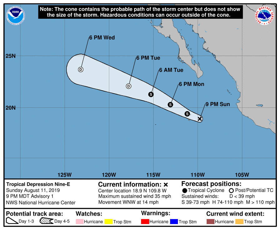
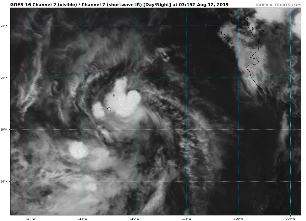
024930_5day_cone_no_line_and_wind.png goes16_vis-swir_09E_201908120315.jpg

回復

使用道具 舉報

簽到天數: 2141 天

[LV.Master]伴壇終老

周子堯@FB|2019-8-12 17:59 | 顯示全部樓層
19/08/12/09Z命名~
000
WTPZ44 KNHC 120836
TCDEP4

Tropical Storm Henriette Discussion Number   2
NWS National Hurricane Center Miami FL       EP092019
300 AM MDT Mon Aug 12 2019

Deep convection has continued to burst over the western portion of
the cyclone overnight.  Although the system is sheared with the
center located near the northeastern edge of the convective mass, a
couple of ASCAT passes have shown a very small area of 30-35 kt
winds over the northwestern portion of the circulation.  These
winds extend no more than about 15-20 n mi from the center, but
based on these data the initial wind speed has been increased to
35 kt.  Henriette becomes the eighth named storm in the eastern
Pacific basin this season.

The ASCAT data also assisted in locating the center this morning,
and recent fixes show that Henriette continues to move west-
northwestward or 295/12 kt. The tropical storm should move
west-northwestward around the southwestern portion of a deep-layer
ridge that extends westward from northern Mexico.  As Henriette
weakens, it is likely to turn westward within the low-level flow.
The updated NHC track forecast is similar to the previous advisory
through 36 hours, but has been adjusted southward at 48 hours to be
closer to the various consensus aids.

Henriette is not anticipated to strengthen much more.  Although the
system is predicted to remain over warm waters and within an area of
light to moderate northeasterly shear today, nearby dry mid-level
air is likely to prevent significant strengthening.  By Tuesday
morning, Henriette will be moving over cooler waters and into a
more stable airmass.  This should lead to weakening, and the
cyclone is predicted to degenerate into a remnant low within
48 hours, with dissipation occurring shortly thereafter.


FORECAST POSITIONS AND MAX WINDS

INIT  12/0900Z 19.5N 110.9W   35 KT  40 MPH
12H  12/1800Z 20.2N 112.4W   35 KT  40 MPH
24H  13/0600Z 21.0N 114.4W   35 KT  40 MPH
36H  13/1800Z 21.7N 116.8W   30 KT  35 MPH
48H  14/0600Z 22.0N 120.0W   25 KT  30 MPH...POST-TROP/REMNT LOW
72H  15/0600Z...DISSIPATED

$$
Forecaster Brown


回復

使用道具 舉報

快速回覆
您需要登錄後才可以回帖 登錄 | 立即加入

本版積分規則

周子堯@FB

    主題

    帖子

    94萬

    積分

    13級[一級颶風]

    Rank: 13Rank: 13Rank: 13Rank: 13

13級[一級颶風]

發訊息

本平台僅供學術討論之用,預報應以氣象局為準

威普網站虛擬主機贊助公司

臺灣第一個天氣類型社群平台 即時天氣資訊、精準颱風動態

線上客服
FB傳送訊息
廣告行銷
精準行銷 物超所值
官方粉專
發佈 快速回復 返回頂部 返回列表