開啟輔助訪問
 找回密碼
 立即加入

14E.Mario

簽到天數: 2414 天

[LV.Master]伴壇終老

2019-9-16 14:47 | 顯示全部樓層
  熱帶風暴  
編號:14 E
名稱:Mario

  基本資料  
擾動編號日期:2019 09 16 14
命名日期  :2019 09 18 05
撤編日期  :2019 09 24 19
登陸地點  :

  巔峰時期資料  
近中心最強風速:55  kt
海平面最低氣壓:992 百帕

  過去路徑圖  

  討論帖圖片  
91E.INVEST.15kts.1009mb.13N.103W

20190916.0620.goes-16.ir.91E.INVEST.15kts.1009mb.13N.103W.100pc.jpg

  NHC:40%  
1. Showers and thunderstorms have increased tonight in association with
an area of low pressure centered several hundred miles
south-southwest of Manzanillo, Mexico.  Conditions are conducive for
additional development, and a tropical depression could form within
the next two to three days.  After mid week, this system is likely
to interact or merge with the disturbance to its east, and further
development after that time is not anticipated.
* Formation chance through 48 hours...medium...40 percent.
* Formation chance through 5 days...medium...50 percent.

two_pac_2d1.png

以上資料來自:NHC、颱風論壇整理製作

評分

參與人數 1水氣能量 +15 +1 收起 理由
t02436 + 15 + 1

查看全部評分

回復

使用道具 舉報

簽到天數: 1650 天

[LV.Master]伴壇終老

老農民版夜神月|2019-9-17 01:15 | 顯示全部樓層
JTWC16/1600Z發布TCFA
WTPN21 PHNC 161600
MSGID/GENADMIN/JOINT TYPHOON WRNCEN PEARL HARBOR HI//
SUBJ/TROPICAL CYCLONE FORMATION ALERT (INVEST 91E)//
RMKS/
1. FORMATION OF A SIGNIFICANT TROPICAL CYCLONE IS POSSIBLE WITHIN
160 NM EITHER SIDE OF A LINE FROM 9.7N 106.8W TO 15.6N 111.7W
WITHIN THE NEXT 12 TO 24 HOURS. AVAILABLE DATA DOES NOT JUSTIFY
ISSUANCE OF NUMBERED TROPICAL CYCLONE WARNINGS AT THIS TIME.
WINDS IN THE AREA ARE ESTIMATED TO BE 25 TO 30 KNOTS. METSAT
IMAGERY AT 161200Z INDICATES THAT A CIRCULATION CENTER IS LOCATED
NEAR 10.5N 107.5W. THE SYSTEM IS MOVING WESTWARD AT 09 KNOTS.
2. REMARKS: AN AREA OF CONVECTION (INVEST 91E) HAS PERSISTED NEAR
10.5N 107.5W, APPROXIMATELY 545 NM SOUTH-SOUTHWEST OF MANZANILLO,
MEXICO. ANIMATED ENHANCED INFRARED SATELLITE IMAGERY AND A 161219Z
91GHZ SSMIS MICROWAVE IMAGE DEPICT FLARING CONVECTION TAKING ON SOME
MIDLEVEL ROTATION ABOVE AN ELONGATED LOW LEVEL CIRCULATION (LLC).
THE ENVIRONMENT IS OVERALL MARGINAL, WITH LOW-MODERATE (15-20KT)
VERTICAL WIND SHEAR, NEUTRAL UPPER LEVEL DIVERGENCE OVER THE LLC,
AND WARM (29-31C) SEA SURFACE TEMPERATURES. GLOBAL MODELS GENERALLY
AGREE ON INVEST 91E TRACKING NORTHWEST AS IT CONTINUES TO DEVELOP,
WITH THE POSSIBILITY OF ABSORBING INVEST 92E WHICH IS LOCATED TO THE
EAST. MAXIMUM SUSTAINED SURFACE WINDS ARE ESTIMATED AT 25 TO 30
KNOTS. MINIMUM SEA LEVEL PRESSURE IS ESTIMATED TO BE NEAR 1000 MB.
THE POTENTIAL FOR THE DEVELOPMENT OF A SIGNIFICANT TROPICAL CYCLONE
WITHIN THE NEXT 24 HOURS IS HIGH.
3. THIS ALERT WILL BE REISSUED, UPGRADED TO WARNING OR CANCELLED BY
171600Z.//
NNNN
ep9119.gif 91E_161500sair.jpg
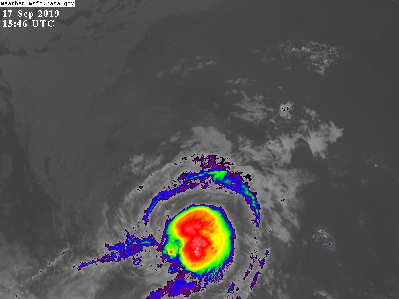
GOES16502019259J27s7Z.jpg

回復

使用道具 舉報

簽到天數: 1650 天

[LV.Master]伴壇終老

老農民版夜神月|2019-9-17 02:07 | 顯示全部樓層
NHC展望提升至High,80%/80%
1. A small area of low pressure centered several hundred miles
south-southwest of Manzanillo, Mexico, continues to become better
organized.  Any significant increase in organized thunderstorm
activity will likely result in the formation of a tropical
depression tonight or tomorrow.  Beyond mid week, strong upper-level
winds from the system to the east could inhibit further development
while the low moves slowly west-northwestward or northwestward.
* Formation chance through 48 hours...high...80 percent.
* Formation chance through 5 days...high...80 percent.

two_pac_2d10916.png two_pac_5d10916.png

回復

使用道具 舉報

簽到天數: 3291 天

[LV.Master]伴壇終老

t02436|2019-9-17 23:53 | 顯示全部樓層
升格14E,上望75節。
000
WTPZ44 KNHC 171448
TCDEP4

Tropical Depression Fourteen-E Discussion Number   1
NWS National Hurricane Center Miami FL       EP142019
900 AM MDT Tue Sep 17 2019

Deep convection has intensified over the small area of low pressure
that NHC has been monitoring for several days.  Both SAB and TAFB
estimates indicate that there is now enough organized thunderstorm
activity to initiate advisories on a tropical depression, and the
initial wind speed of 30 kt matches the overnight scatterometer
data and the subjective Dvorak estimates.

The initial motion is an uncertain 335/8 kt, with steering provided
by a distant low-level ridge to the east.  The cyclone is forecast
to gradually turn toward the northwest and west-northwest during the
next several days as it runs into the southwestern side of a mid-
latitude ridge centered over northwestern Mexico. The biggest
complication is Tropical Storm Lorena to the northeast, which some
of the model guidance, such as the 6Z GFS, shows a binary
interaction with at longer term, which could induce a more northward
motion. While I can't rule that out, the forecast will stay closer
to the models that show less interaction, such as the more westward
HWRF and ECMWF solutions, and the NHC forecast is close to a blend
of those models.

While almost all of the guidance indicates strengthening of this
depression into a hurricane in a few days, this forecast is
problematic because of the proximity to Lorena.  Convective outflow
from Lorena could induce more easterly shear than is currently
forecast if the tracks get closer together.  For now, since the
cyclones are forecast to remain a fair distance from one another,
this wind speed prediction assumes that the low-shear environment in
most of the models materializes, and the forecast follows the
corrected-consensus intensity guidance HCCA.

FORECAST POSITIONS AND MAX WINDS

INIT  17/1500Z 11.9N 108.2W   30 KT  35 MPH
12H  18/0000Z 12.9N 108.9W   35 KT  40 MPH
24H  18/1200Z 14.5N 110.2W   45 KT  50 MPH
36H  19/0000Z 15.7N 111.8W   50 KT  60 MPH
48H  19/1200Z 16.5N 113.0W   55 KT  65 MPH
72H  20/1200Z 17.1N 114.1W   70 KT  80 MPH
96H  21/1200Z 17.3N 115.3W   75 KT  85 MPH
120H  22/1200Z 17.5N 117.0W   60 KT  70 MPH

$$
Forecaster Blake
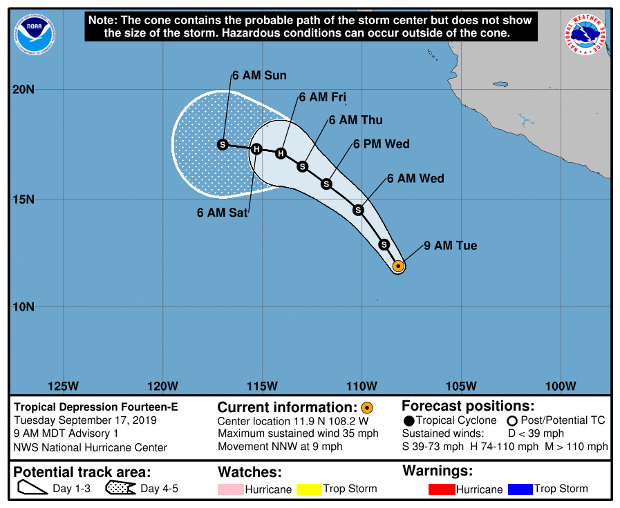
144926_5day_cone_with_line.png

GOES15462019260KGwObH.jpg
回復

使用道具 舉報

簽到天數: 1650 天

[LV.Master]伴壇終老

老農民版夜神月|2019-9-18 07:36 | 顯示全部樓層
NHC17/21Z報升格14E為TS,命名Mario
746
WTPZ44 KNHC 172038
TCDEP4

Tropical Storm Mario Discussion Number   2
NWS National Hurricane Center Miami FL       EP142019
300 PM MDT Tue Sep 17 2019

Thunderstorm activity continues to grow over the center of the
cyclone, with a banding feature trying to form in the western
semicircle.  While the subjective estimates are unchanged from
earlier, the objective estimates are rising, which matches the
increased convective organization trend on satellites.  Thus the
initial wind speed is bumped up to 35 kt on this advisory.

Mario is moving northwestward, with that general motion anticipated
for the next two days due primarily to a mid-latitude ridge centered
over northwestern Mexico.  A slow west-northwest track is forecast
at long-range due to the orientation of the weakening ridge. Global
models have come into much better agreement overall, and the new NHC
track forecast is shifted to the west during the next few days since
the models suggest little-to-no interaction with Tropical Storm
Lorena.

With the guidance showing less interaction with Lorena, it seems
probable that further strengthening will occur in a low-shear,
warm-water environment.  Interestingly, the guidance is actually
lower than this morning, although it is difficult to pinpoint any
reasons for the change. I've elected to let the morning forecast
ride for one more advisory to see if the guidance comes back
upward, and the latest wind speed prediction is at the upper end of
the guidance envelope.


FORECAST POSITIONS AND MAX WINDS

INIT  17/2100Z 12.3N 108.7W   35 KT  40 MPH
12H  18/0600Z 13.3N 109.7W   40 KT  45 MPH
24H  18/1800Z 14.7N 111.3W   50 KT  60 MPH
36H  19/0600Z 15.8N 112.6W   55 KT  65 MPH
48H  19/1800Z 16.5N 113.5W   60 KT  70 MPH
72H  20/1800Z 16.8N 114.3W   70 KT  80 MPH
96H  21/1800Z 17.0N 115.0W   70 KT  80 MPH
120H  22/1800Z 18.0N 116.5W   60 KT  70 MPH

$$
Forecaster Blake
203923_5day_cone_no_line_and_wind.png ep1419.0gif.gif
14E_171800sair.jpg goes16_ir_14E_201909172315.jpg

回復

使用道具 舉報

快速回覆
您需要登錄後才可以回帖 登錄 | 立即加入

本版積分規則

0908morakot

    主題

    帖子

    69萬

    積分

    12級[颶風Hurricane]

    Rank: 12Rank: 12Rank: 12

12級[颶風Hurricane]

發訊息

本平台僅供學術討論之用,預報應以氣象局為準

威普網站虛擬主機贊助公司

臺灣第一個天氣類型社群平台 即時天氣資訊、精準颱風動態

線上客服
FB傳送訊息
廣告行銷
精準行銷 物超所值
官方粉專
發佈 快速回復 返回頂部 返回列表