開啟輔助訪問
 找回密碼
 立即加入

13L.Lorenzo 二次巔峰短暫上C5 大西洋中部北上轉化

簽到天數: 1650 天

[LV.Master]伴壇終老

老農民版夜神月|2019-9-27 01:12 | 顯示全部樓層
本帖最後由 老農民版夜神月 於 2019-9-27 01:37 編輯

NHC26/15Z報判定達標C4,並預測此系統後續仍有略微增強的趨勢
501
WTNT43 KNHC 261453
TCDAT3

Hurricane Lorenzo Discussion Number  16
NWS National Hurricane Center Miami FL       AL132019
1100 AM AST Thu Sep 26 2019

A review of microwave satellite imagery from last night suggests
that Lorenzo underwent an eyewall replacement cycle, with the
outer eyewall becoming predominant around 06Z-09Z.  Around that
time, the hurricane started to rapidly intensify, with the eye
becoming much better defined in conventional satellite imagery.  Raw
Data-T numbers from both subjective and objective versions of the
Dvorak Technique suggest that the maximum winds have increased to
near 115 kt, which will be the initial intensity for this advisory.
The initial wind radii have been revised based on a recently
received scatterometer overpass.

The initial motion is 295/11.  Lorenzo is approaching a developing
break in the subtropical ridge caused by a series of mid-latitude
troughs to the northwest of the hurricane, and the track guidance
models are in excellent agreement that Lorenzo should recurve
through the break during the forecast period.  There are no
significant changes to the guidance since the last advisory, and
there are no significant changes to the forecast track either.

Data from the SHIPS model suggest that Lorenzo will be in an area
of maximum potential intensities of 125-135 kt for the next 3-4
days.  This suggests that the rapid intensification should end in
the next 6-12 h as the actual intensity approaches those speeds.
Fluctuations in strength due to eyewall replacement cycles are
expected during the 12-36 h period.  The global models suggest
that Lorenzo will subsequently interact with an upper-level trough
during recurvature, which should cause a period of increased shear
and some weakening of the cyclone around 48 h.  By 120 h, the
hurricane should weaken due to movement over colder water and into
strong shear in the mid-latitude westerlies.

While its exact ranking will be determined later, Lorenzo is one of
the largest and most powerful hurricanes of record for the central
tropical Atlantic, with the only comparable hurricane in recent
times near there being Gabrielle of 1989.


FORECAST POSITIONS AND MAX WINDS

INIT  26/1500Z 15.4N  40.2W  115 KT 130 MPH
12H  27/0000Z 16.7N  41.4W  125 KT 145 MPH
24H  27/1200Z 18.5N  42.6W  125 KT 145 MPH
36H  28/0000Z 20.2N  43.5W  120 KT 140 MPH
48H  28/1200Z 21.9N  43.9W  110 KT 125 MPH
72H  29/1200Z 25.2N  43.3W  100 KT 115 MPH
96H  30/1200Z 29.0N  41.0W  100 KT 115 MPH
120H  01/1200Z 34.0N  37.0W   90 KT 105 MPH

$$
Forecaster Beven

145442_5day_cone_no_line_and_wind.png goes16_wv-mid_13L_201909261525.jpg
GOES16502019269CmmHA9.jpg goes16_vis-swir_13L_201909261305.jpg
goes16_ir_13L_201909261525.jpg goes16_ir-dvorak_13L_201909261625.jpg

回復

使用道具 舉報

簽到天數: 3279 天

[LV.Master]伴壇終老

t02436|2019-9-27 14:00 | 顯示全部樓層
已轉西北進行,03Z再調升評價至125節
000
WTNT43 KNHC 270233
TCDAT3

Hurricane Lorenzo Discussion Number  18
NWS National Hurricane Center Miami FL       AL132019
1100 PM AST Thu Sep 26 2019

Lorenzo has intensified even more this evening, with a clear eye
characterized by warm temperatures of up to 17 degrees
Celsius. The eye is now completely surrounded by a ring of
convection with cold cloud tops less than minus 70 degrees Celsius.
The subjective Dvorak intensity estimates from both TAFB and SAB,
as well as the objective intensity estimate from UW-CIMSS ADT
unanimously support increasing the initial intensity to 125 kt.
Lorenzo is a very large hurricane, with tropical storm force winds
extending over 200 n mi from the center in the northern semicircle
,
and a cirrus cloud canopy that spans greater than a 10 degree
latitude by 10 degree longitude area.

The initial motion is now north-northwest, or 330/12 kt. Model
guidance is in very good agreement throughout the 5 day period on
the future track of Lorenzo. The hurricane will move through a break
in the subtropical ridge currently to its northwest over the next
couple of days, gradually turning to the north then northeast as it
rounds the periphery of a ridge to its east. Late in the forecast
period, Lorenzo will begin to accelerate as it gets caught in
southwesterly flow ahead of an approaching mid-latitude trough. The
model guidance made a slight shift to the left since the previous
advisory, but since the same guidance shifted right earlier today, I
did not want to make much of a change to the track. The official
forecast track is very near the previous one, and is now on the
right side of the consensus guidance.

The environment around Lorenzo is expected to change little over
the next day or so. Both dynamical and statistical guidance are
suggesting that the hurricane is nearing peak intensity. Therefore
only fluctuations in strength due to eyewall replacement cycles are
expected through about Friday night. Over the weekend, some moderate
westerly shear ahead of the approaching mid-latitude trough could
begin to slowly weaken the cyclone. Late in the forecast period,
the combination of strong upper level southwesterly winds and
cooler sea surface temperatures should cause a faster weakening
trend. The official forecast is essentially an update of the
previous one, and a little higher than most of the guidance through
the first 48 hours.

FORECAST POSITIONS AND MAX WINDS

INIT  27/0300Z 17.6N  41.5W  125 KT 145 MPH
12H  27/1200Z 19.1N  42.3W  125 KT 145 MPH
24H  28/0000Z 21.0N  43.3W  120 KT 140 MPH
36H  28/1200Z 22.7N  43.8W  115 KT 130 MPH
48H  29/0000Z 24.4N  43.6W  110 KT 125 MPH
72H  30/0000Z 27.8N  41.8W  100 KT 115 MPH
96H  01/0000Z 31.8N  39.0W   95 KT 110 MPH
120H  02/0000Z 37.5N  33.2W   85 KT 100 MPH

$$
Forecaster Latto

023458_5day_cone_with_line.png

GOES05402019270nK7Okv.jpg

20190927.0530.goes-16.ir.13L.LORENZO.125kts.939mb.17.1N.41.2W.100pc.jpg
回復

使用道具 舉報

簽到天數: 53 天

[LV.5]常住居民I

天篷大元帥|2019-9-29 15:01 | 顯示全部樓層
美國國家颶風中心:140節
在我印象中從來沒有記錄過不曾以熱帶氣旋狀態登陸的五級颶風,這會是有史以來第一次嗎!?值得觀察。
以下為國家颶風中心的資料
000 (原文)
WTNT43 KNHC 290235
TCDAT3

Hurricane Lorenzo Discussion Number  27
NWS National Hurricane Center Miami FL       AL132019
1100 PM AST Sat Sep 28 2019

Lorenzo has rapidly strengthened this evening.  An eyewall
replacement cycle completed earlier today, with a recent SSMIS
microwave overpass showing that a new eyewall about 30 n mi in
diameter now completely encircles the eye.  The cold cloud tops
surrounding the eye have expanded, with a solid ring of temperatures
measuring colder than minus 70 degrees Celsius.  In addition, the
eye has cleared, with satellite derived cloud-top temperatures now
above 15 degrees Celsius.  Throughout the evening, the objective and
subjective intensity estimates have climbed, with 0130 UTC special
classifications from TAFB and SAB as well as a recent UW-CIMSS ADT
estimate unanimously agreeing on a 140-kt initial intensity.  This
makes Lorenzo an extremely dangerous category 5 hurricane.


The initial motion is now northward at 9 kt.  Lorenzo will be
steered north through a break between two subtropical ridges through
tonight, with a turn to the north-northeast expected on Sunday.
After Sunday, Lorenzo will begin to get caught up in increasing
southwesterly flow ahead of an approaching mid-latitude trough. This
will cause the cyclone to accelerate northeastward through the end
of the forecast period.  The official track forecast is essentially
an update of the previous one, and is near the middle of the
consensus aids.

Lorenzo will likely peak in intensity overnight as it remains in the
current favorable environment.  Some fluctuations in intensity are
possible on Sunday mainly due to eyewall replacement cycles.  By
Sunday night, Lorenzo will begin to feel the effects of some
southwesterly shear ahead of the approaching trough, while it also
moves over waters of lower oceanic heat content.  These factors
should induce a steady weakening trend through 48 hours.  After that
time, SSTs below 26 C should cause a faster weakening trend.  By 72
hours, the cyclone will begin interacting with the approaching
trough and an associated cold front, which will begin a transition
to an extratropical low.  This transition is forecast to complete by
120 hours, but it could happen a little sooner than that.  The
official forecast was increased through the first 48 hours due to
the increase in initial intensity, and then blends to near the
previous official forecast by 72 hours.

With this latest advisory intensity, Lorenzo becomes the strongest
hurricane in history this far north and east in the Atlantic basin.


Key Messages:

1.  Lorenzo is a large hurricane, and its hurricane- and
tropical-storm-force wind fields are expected to expand further
during the next several days.  Regardless of Lorenzo's exact track
near the Azores, strong winds are becoming increasingly likely on
the islands Tuesday night and Wednesday, and residents there should
monitor the progress of the hurricane.

2.  Large swells generated by Lorenzo will continue to spread across
much of the western and northern parts of the Atlantic basin during
the next few days.  These swells will produce life-threatening surf
and rip currents.


FORECAST POSITIONS AND MAX WINDS

INIT  29/0300Z 24.2N  44.9W  140 KT 160 MPH
12H  29/1200Z 25.5N  44.7W  135 KT 155 MPH
24H  30/0000Z 27.1N  44.1W  125 KT 145 MPH
36H  30/1200Z 28.8N  43.3W  115 KT 130 MPH
48H  01/0000Z 30.8N  42.0W  105 KT 120 MPH
72H  02/0000Z 36.7N  35.3W   95 KT 110 MPH
96H  03/0000Z 45.0N  23.5W   75 KT  85 MPH
120H  04/0000Z 52.2N  10.7W   60 KT  70 MPH...POST-TROP/EXTRATROP

$$
Forecaster Latto
000(僅供參考的機器翻譯)
WTNT43 KNHC 290235
TCDAT3

洛倫佐颶風討論編號27
新創建國家颶風中心邁阿密FL AL132019
AST AST PM 2019年9月28日下午1100

洛倫佐(Lorenzo)今天晚上迅速加強。眼牆
更換週期已於今天早些時候完成,而最近的SSMIS
微波立交橋顯示,在30英里左右處有一個新的眼牆
直徑現在完全包圍了眼睛。冷雲頂
眼睛周圍已擴大,溫度穩定
測量溫度低於攝氏零下70度。除此之外
眼神已清除,現在有了衛星得出的雲頂溫度
高於15攝氏度。整個晚上,目標和
0130 UTC特別版,主觀強度估計有所提高
TAFB和SAB以及最新的UW-CIMSS ADT中的分類
估計一致同意140 kt的初始強度。這個
使洛倫佐成為極端危險的5級颶風。

現在的初始運動是向北移動9 kt。洛倫佐將
通過兩個亞熱帶山脊之間的斷裂帶向北
今晚,預計將在周日轉向東北東北部。
星期日之後,洛倫佐(Lorenzo)將開始陷入困境
在接近中緯度谷之前向西南方向流動。這個
最終將導致旋風向東北加速
預測期。官方的天氣預報基本上是
前一個的更新,並且在
共識幫助。

洛倫佐(Lorenzo)可能會在一夜之間達到強度峰值,因為它仍然存在於
當前的有利環境。強度的一些波動是
可能在周日出現,主要是由於眼牆更換週期。通過
星期天晚上,洛倫佐(Lorenzo)將開始感受到一些
在即將來臨的低谷之前向西南方向剪切,同時它也
在海洋熱量較低的水域上移動。這些因素
應在48小時內引起穩定的減弱趨勢。之後
時間,低於26 C的SST將導致更快的減弱趨勢。乘72
小時,旋風將開始與臨近
槽和相關的冷鋒,這將開始過渡
到溫帶低點。預計此過渡將在以下時間完成
120小時,但可能會比這早一點。該
由於以下原因,官方預測在前48小時內有所增加:
初始強度的增加,然後融合到附近
之前的官方預報是72小時。

憑藉最新的諮詢強度,洛倫佐成為最強的諮詢人
大西洋盆地北部和東部的歷史颶風。


關鍵信息:

1.洛倫佐(Lorenzo)是大颶風,其颶風-和
熱帶風暴風場有望進一步擴大
在接下來的幾天中。不管洛倫佐的確切足跡如何
在亞速爾群島附近,大風的可能性越來越大
星期二晚上和星期三這些島嶼,那裡的居民應該
監視颶風的進度。

2.洛倫佐(Lorenzo)產生的大浪將繼續擴散
在此期間,大西洋盆地的西部和北部大部分地區
接下來的幾天。這些浪潮會產生威脅生命的衝浪
和裂口電流。


預測位置和最大風

初始29 / 0300Z 24.2N 44.9W 140 KT 160 MPH
12H 29 / 1200Z 25.5N 44.7W 135 KT 155 MPH
24H 30 / 0000Z 27.1N 44.1W 125 KT 145 MPH
36H 30 / 1200Z 28.8N 43.3W 115 KT 130 MPH
48H 01 / 0000Z 30.8N 42.0W 105 KT 120 MPH
72H 02 / 0000Z 36.7N 35.3W 95 KT 110 MPH
96H 03 / 0000Z 45.0N 23.5W 75 KT 85 MPH
120H 04 / 0000Z 52.2N 10.7W 60 KT 70 MPH ... POST-TROP / EXTRATROP

$$
預報員拉托


預報圖

預報圖
回復

使用道具 舉報

簽到天數: 53 天

[LV.5]常住居民I

天篷大元帥|2019-10-2 13:39 | 顯示全部樓層
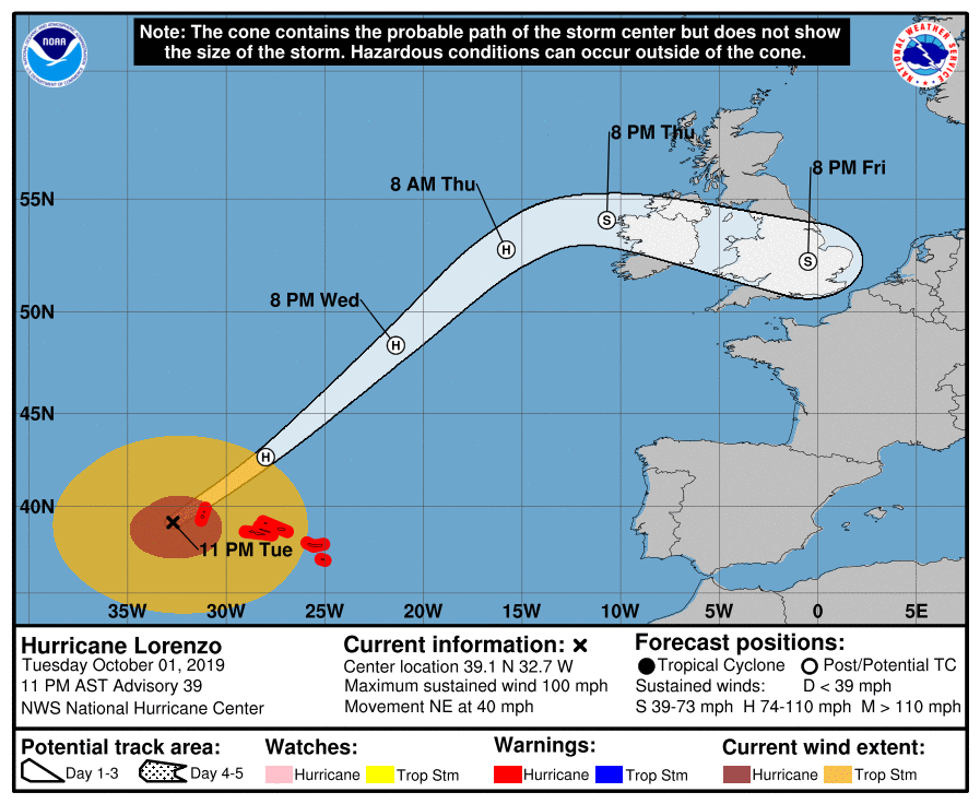
亞速爾群島正在颶風警告的範圍內,國家颶風中心預告12小時內會成為溫帶風暴。
(以下是該機構資料)
000 (原文)
WTNT43 KNHC 020249
TCDAT3

Hurricane Lorenzo Discussion Number  39
NWS National Hurricane Center Miami FL       AL132019
1100 PM AST Tue Oct 01 2019

Lorenzo's convective cloud pattern has eroded significantly during
the past 6 hours, with an eye no longer evident in infrared
satellite imagery.  However, a ragged remnant eye feature is still
present in passive microwave imagery, and that data indicates that
the mid- and upper-level circulations are tilted about 15-20 nmi
northeast of the low-level center due to strong southwesterly
vertical wind shear of 25-30 kt. Satellite intensity estimates have
also decreased and now support around 75 kt. However, the intensity
is being maintained at 85 kt due to Lorenzo's faster forward speed,
which is now about 10 kt more than it was on the previous advisory,
offsetting the possible decrease in the tangential winds.  The 64-,
50-, and 34-kt wind radii had to once again be expanded in nearly
every quadrant, but especially to the southeast, based on a 2305 UTC
ASCAT-B overpass. The larger wind field is now expected to result in
sustained hurricane-force winds occurring across portions of the
western and central Azores on Wednesday morning.

Despite the hurricane's extremely large size, Lorenzo has continued
to accelerate northeastward and is now moving 045/35 kt. Lorenzo's
forward speed should gradually level off near 40 kt on Wednesday,
and then gradually begin to decrease by Thursday morning when the
cyclone turns more eastward toward Ireland.  By late Thursday,
post-tropical Lorenzo is forecast to turn east-southeastward,
crossing Ireland and southern England. The latest NHC model guidance
is tightly packed about the previous forecast track, so only minor
tweaks were required, and new advisory lies close to an average of
the various consensus model forecast tracks.

Lorenzo is currently moving over sea-surface temperatures (SST) near
24 deg C, and that isn't taking into account any cold upwelling that
is likely occurring beneath the very large hurricane.  With only
colder water ahead of the cyclone, coupled with vertical shear
increasing to more than 40 kt by 12 hours, rapid transition to a
powerful post-tropical/extratropical cyclone is expected shortly
after Lorenzo passes the Azores.  However, only gradual weakening is
foreast during the next 24 hours due to baroclinic interaction with
an upper-level trough and frontal system.  After that time, a more
rapid rate of weakening is expected when Lorenzo will be moving over
Ireland and England.

Lorenzo's expansive circulation is producing very large seas over
the north Atlantic. Full information can be found in High Seas
Forecasts from the following agencies:

The NOAA Ocean Prediction Center under AWIPS header NFDHSFAT1, WMO
header FZNT01 KWBC, and online at
ocean.weather.gov/shtml/NFDHSFAT1.php

The UK Met Office under WMO header FQNT21 EGRR and online at
http://www.metoffice.gov.uk/public/weather/marine-high-seas/

Meteo France under WMO header FQNT50 LFPW and online at
http://www.meteofrance.com/previsions-meteo-marine/bulletin/
grandlarge/metarea2

Key Messages:

1.  Lorenzo is expected to bring hurricane- and tropical-storm-force
winds to the Azores beginning within the next couple of hours, with
those dangerous conditions continuing into Wednesday afternoon.
Hurricane and Tropical Storm Warnings are in effect for the Azores.

2.  Swells generated by Lorenzo have spread across much of the
North Atlantic, and are affecting the east coast of the United
States, Atlantic Canada, the Bahamas, portions of the Greater and
Lesser Antilles, and portions of the coast of Europe.  These swells
will produce life-threatening surf and rip currents.


FORECAST POSITIONS AND MAX WINDS

INIT  02/0300Z 39.1N  32.7W   85 KT 100 MPH
12H  02/1200Z 42.7N  28.0W   75 KT  85 MPH...POST-TROP/EXTRATROP
24H  03/0000Z 48.4N  21.4W   70 KT  80 MPH...POST-TROP/EXTRATROP
36H  03/1200Z 52.8N  15.8W   65 KT  75 MPH...POST-TROP/EXTRATROP
48H  04/0000Z 54.1N  10.7W   55 KT  65 MPH...POST-TROP/EXTRATROP
72H  05/0000Z 52.3N    .5W   35 KT  40 MPH...POST-TROP/EXTRATROP
96H  06/0000Z...DISSIPATED

$$
Forecaster Stewart
000 (僅供參考的機器翻譯)
WTNT43 KNHC 020249
TCDAT3

颶風洛倫佐討論編號39
NWS國家颶風中心邁阿密FL AL132019
1100 PM AST星期二2019年10月1日

洛倫佐的對流雲模式在
過去6個小時中已明顯腐蝕,在紅外
衛星圖像中不再可見。然而,
被動微波成像中仍存在殘存的殘眼特徵,該數據表明,
由於強西南
風垂直切變,中
高層環流向低層中心東北方向傾斜了15-20 nmi 。 25-30克拉 衛星強度估計值
也有所降低,目前約為75 kt。但是,強度
由於Lorenzo的前進速度較快,因此將其保持在85 kt,
現在比以前的通報要快10 kt,從而
抵消了切向風的可能減少。在64,
50-,和34-KT風半徑不得不再次擴大在幾乎
每一個象限,尤其是東南的基礎上,2305 UTC
ASCAT-B立交橋。現在預計更大的風場將導致
周三上午在亞速爾群島中西部的
部分地區發生持續的颶風風。

儘管颶風規模很大,但洛倫佐仍繼續
向東北加速發展,現在移動045/35 kt。羅倫佐的
前進速度應在周三接近40 kt時逐漸趨於平穩,
然後在周四早晨逐漸
向東移向愛爾蘭時逐漸降低。到週四晚,
預計熱帶後洛倫佐將東偏東,
穿過愛爾蘭和英格蘭南部。最新的NHC模型指南
與先前的預測軌跡緊密相關,因此僅需進行一些細微
調整,並且新的建議接近
各種共識模型預測軌蹟的平均值。

洛倫佐目前正在超過
24攝氏度的海面溫度(SST)上移動,這並未考慮到
在超大颶風下可能發生的任何冷上升流。僅
旋風分離器前的水較冷,加上垂直剪切力
在12小時內增加到40 kt以上,
預計
在Lorenzo經過亞速爾群島後不久,將迅速過渡到強大的後熱帶/偏熱帶氣旋。但是,
由於斜壓作用與
上層海槽和額葉系統的相互作用,接下來的24小時內只會逐漸減弱。在那之後,
當洛倫佐(Lorenzo)將越過
愛爾蘭和英國時,預計將出現更快的減弱速度。

洛倫佐(Lorenzo)的廣闊環流正在
北大西洋上空產生巨大的海洋。可以
在以下機構的“ 公海預報”中找到完整的信息:

NOAA海洋預報中心位於AWIPS標頭NFDHSFAT1,WMO
標頭FZNT01 KWBC下,並在線位於
ocean.weather.gov/shtml/NFDHSFAT1.php

英國氣象局位於WMO標頭FQNT21 EGRR下並在線位於
http://www.metoffice.gov .uk / public / weather / marine-high-seas /

Meteo France,位於WMO標頭FQNT50 LFPW下,並在線位於
http://www.meteofrance.com/previsions-meteo-marine/bulletin/
grandlarge / metarea2

關鍵消息:

1. Lorenzo預計
在接下來的幾個小時內將把颶風和熱帶風暴的力量帶到亞速爾群島,而
這些危險情況一直持續到星期三下午。
颶風和熱帶風暴警告對亞速爾群島有效

2.洛倫佐(Lorenzo)產生的海浪已經擴散到
北大西洋的大部分地區,並正在影響美國的東海岸
,加拿大的大西洋,巴哈馬,大和
小安的列斯群島的部分地區以及歐洲的部分地區。這些膨脹
會產生危及生命的海浪和裂隙電流。


預測位置和最大

風速初始化02 / 0300Z 39.1N 32.7W 85 KT 100 MPH
12H 02 / 1200Z 42.7N 28.0W 75 KT 85 MPH ...後轉/後轉
24H 03 / 0000Z 48.4N 21.4W 70 KT 80 MPH。 ..後衝/超跑
36H 03 / 1200Z 52.8N 15.8W 65 KT 75 MPH ...後衝/超機器人
48H 04 / 0000Z 54.1N 10.7W 55 KT 65 MPH ...後衝/ EXTROTROP
72H 05 / 0000Z 52.3N .5W 35 KT 40 MPH ...後增/增幅
96H 06 / 0000Z ...已廢棄

$$
預報器Stewart


預報圖

預報圖
回復

使用道具 舉報

12
快速回覆
您需要登錄後才可以回帖 登錄 | 立即加入

本版積分規則

本平台僅供學術討論之用,預報應以氣象局為準

威普網站虛擬主機贊助公司

臺灣第一個天氣類型社群平台 即時天氣資訊、精準颱風動態

線上客服
FB傳送訊息
廣告行銷
精準行銷 物超所值
官方粉專
發佈 快速回復 返回頂部 返回列表