開啟輔助訪問
 找回密碼
 立即加入

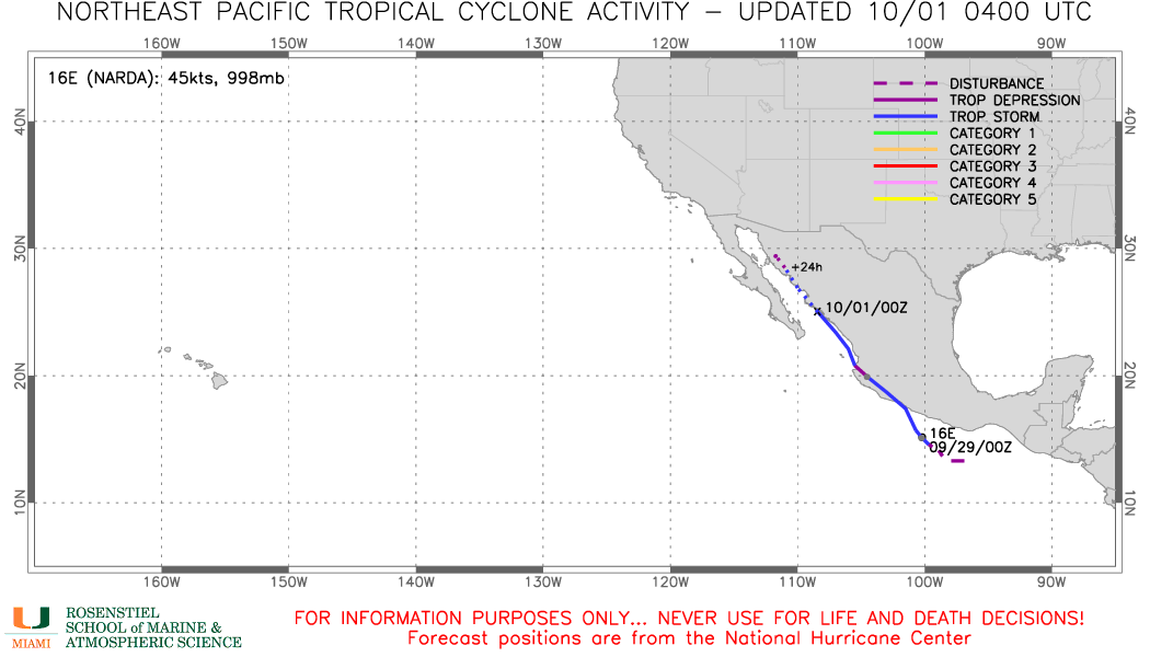
16E.Narda 沿墨西哥西岸近岸北上 三次登陸

簽到天數: 2414 天

[LV.Master]伴壇終老

2019-9-28 00:09 | 顯示全部樓層
  熱帶風暴  
編號:16 E
名稱:Narda

  基本資料  
擾動編號日期:2019 09 27 23
命名日期  :2019 09 29 11
撤編日期  :2019 10 02 19
登陸地點  :墨西哥 克雷塔羅州
           阿瓜斯卡連特斯州
           坎佩切州

  巔峰時期資料  
近中心最強風速:45  kt
海平面最低氣壓:998 百帕

  過去路徑圖  

  討論帖圖片  
94E.INVEST.25kts.1006mb.13.3N.98.2W

20190927.1440.goes-16.ir.94E.INVEST.25kts.1006mb.13.3N.98.2W.100pc.jpg

  NHC:60%  
2. A large area of disorganized showers and thunderstorms located near
the southern and southwestern coast of Mexico is associated with an
elongated surface trough.  A low pressure system is forecast to
develop along this trough during the next day or two, and it is
likely to become a tropical depression or tropical storm this
weekend or early next week while moving west-northwestward to
northwestward at about 10 mph near the southern and southwestern
coast of Mexico.  Regardless of development, heavy rainfall, with
the possibility of flash flooding and mudslides, is expected near
the Pacific coasts of Guatemala and Mexico during the next few days.
* Formation chance through 48 hours...medium...60 percent.
* Formation chance through 5 days...high...80 percent.

two_pac_2d2.png

以上資料來自:NHC、颱風論壇整理製作

評分

參與人數 1水氣能量 +15 +1 收起 理由
t02436 + 15 + 1

查看全部評分

回復

使用道具 舉報

簽到天數: 3291 天

[LV.Master]伴壇終老

t02436|2019-9-29 00:06 | 顯示全部樓層
15Z升格潛在熱帶氣旋16E,僅上望40節。
000
WTPZ41 KNHC 281451
TCDEP1

Potential Tropical Cyclone Sixteen-E Discussion Number   1
NWS National Hurricane Center Miami FL       EP162019
1000 AM CDT Sat Sep 28 2019

The area of disturbed weather along the southwestern coast of Mexico
is gradually becoming better organized. There is no evidence of a
well-defined center at this time, but satellite animation suggests
that a circulation could be forming just south of Acapulco.  Since
there is a risk of tropical-storm-force winds along the coast of
Mexico, the government of Mexico has issued a Tropical Storm Warning
for a portion of southwestern coast, and advisories have been
initiated on Potential Tropical Cyclone 16-E.

Earlier ASCAT data indicate that the disturbance has been producing
winds of about 30 kt, mostly within its southern portion. The large
envelope of the disturbance is interacting with the high terrain of
southern Mexico, and the environment is not ideal for strengthening,
but it is good enough for the disturbance to reach tropical storm
status.  By the end of the forecast period, the shear is expected to
be high, and the system should weaken.

The initial motion is obviously highly uncertain since there is not
a good center to track. The best estimate is toward the northwest
or 315 degrees at 11 kt.  High pressure over the Gulf of Mexico
will continue to steer the disturbance or the cyclone toward
the northwest and then north-northwest very close to the
southwestern coast of Mexico, and then into the Gulf of California.
This is the solution provided by the reliable models.

If the system develops its center closer to the coast, there is a
chance that the circulation moves inland earlier than anticipated
resulting in faster weakening.  Regardless of how strong the system
becomes, torrential rains are expected along the southwestern coast
of Mexico during the next few days.


FORECAST POSITIONS AND MAX WINDS

INIT  28/1500Z 14.9N 100.4W   30 KT  35 MPH...POTENTIAL TROP CYCLONE
12H  29/0000Z 16.0N 101.5W   35 KT  40 MPH...TROPICAL STORM
24H  29/1200Z 17.5N 103.5W   40 KT  45 MPH
36H  30/0000Z 19.5N 105.5W   40 KT  45 MPH
48H  30/1200Z 22.0N 107.5W   40 KT  45 MPH
72H  01/1200Z 26.0N 111.0W   30 KT  35 MPH
96H  02/1200Z 27.0N 111.5W   25 KT  30 MPH
120H  03/1200Z 29.0N 112.0W   20 KT  25 MPH...POST-TROP/REMNT LOW

$$
Forecaster Avila

145243_5day_cone_with_line.png

GOES15502019271ToucCw.jpg
回復

使用道具 舉報

簽到天數: 3291 天

[LV.Master]伴壇終老

t02436|2019-9-29 15:12 | 顯示全部樓層
03Z已命名Narda
234
WTPZ41 KNHC 290242
TCDEP1

Tropical Storm Narda Discussion Number   3
NWS National Hurricane Center Miami FL       EP162019
1000 PM CDT Sat Sep 28 2019

Late afternoon visible satellite imagery and ship observations
show that the disturbance's circulation has become better defined.
In addition, there has been an increase in convective banding around
the western portion of the system.  As a result, the system is
being classified as a tropical storm.  The initial wind speed is
maintained at 35 kt, which is in agreement with earlier
scatterometer data, and the latest TAFB Dvorak classification.

Narda is located within an area of moderate northeasterly
shear and is likely to interact with the mountainous terrain of
southern Mexico on Sunday.  As a result, only slight strengthening
is indicated within the next 24 hours, followed by some weakening
as the system moves near or over the southwestern coast of Mexico.
The latter portion of the intensity forecast is quite uncertain.
If the system tracks to the right of the official forecast it would
likely weaken and dissipate over southern Mexico, but if it remains
farther west or just offshore, it could be stronger than indicated
below.

The tropical storm is moving northwestward at about 8 kt.  A strong
deep-layer ridge over the southeastern United States should
continue to steer the disturbance northwestward during the next
couple of days.  The latest runs of the GFS and ECMWF both take
the system inland within the next 24 hours, however the ensemble
means favor a track near, but just offshore of the coast.  The NHC
forecast is similar to the previous advisory, but the confidence
after 36-48 hours is quite low due to the potential land
interaction.


FORECAST POSITIONS AND MAX WINDS

INIT  29/0300Z 15.4N 100.6W   35 KT  40 MPH
12H  29/1200Z 16.7N 101.6W   40 KT  45 MPH
24H  30/0000Z 18.3N 103.7W   40 KT  45 MPH
36H  30/1200Z 20.3N 105.7W   35 KT  40 MPH
48H  01/0000Z 22.2N 107.4W   40 KT  45 MPH
72H  02/0000Z 24.9N 109.5W   35 KT  40 MPH
96H  03/0000Z 25.5N 109.8W   25 KT  30 MPH
120H  04/0000Z 26.5N 110.0W   20 KT  25 MPH...POST-TROP/REMNT LOW

$$
Forecaster Brown

053400_5day_cone_with_line.png

GOES06502019272jVkzAO.jpg
回復

使用道具 舉報

簽到天數: 3291 天

[LV.Master]伴壇終老

t02436|2019-9-30 01:00 | 顯示全部樓層
路徑比預期東偏,目前中心已在沿岸,稍後將登陸墨西哥,預計24小時後出海仍有重回TS機會。
ZCZC MIATCUEP1 ALL
TTAA00 KNHC DDHHMM

Tropical Storm Narda Tropical Cyclone Update
NWS National Hurricane Center Miami FL       EP162019
915 AM CDT Sun Sep 29 2019

...CENTER OF NARDA NOW NEAR THE COAST OF MEXICO...

Satellite imagery and data from coastal stations in Mexico indicate
that the center of Narda is northwest of the previous advisory
position and it is now located close to the coast of Mexico near
Zihuatanejo.   The Mexican Navy station at Puerto Vicente recently
reported sustained winds of 38 mph (62 km/h) and a wind gust of 52
mph (84 km/h).


SUMMARY OF 915 AM CDT...1315 UTC...INFORMATION
----------------------------------------------
LOCATION...17.6N 101.7W
ABOUT 15 MI...25 KM W OF ZIHUATANEJO MEXICO
MAXIMUM SUSTAINED WINDS...45 MPH...75 KM/H
PRESENT MOVEMENT...NW OR 325 DEGREES AT 15 MPH...24 KM/H
MINIMUM CENTRAL PRESSURE...998 MB...29.47 INCHES

$$
Forecaster Beven
NNNN
333
WTPZ41 KNHC 291456
TCDEP1

Tropical Storm Narda Discussion Number   5
NWS National Hurricane Center Miami FL       EP162019
1000 AM CDT Sun Sep 29 2019

The center of Narda either re-formed to the northwest or
accelerated its forward motion during the night, as surface
observations from Mexico and satellite imagery indicate that it is
now located along the coast of Mexico near Lazaro Cardenas.  The
initial intensity is held at 40 kt based on the Mexican
observations and little change in the satellite intensity estimates
since the last advisory.  First-light visible imagery suggests that
the cyclone's circulation is elongated east-west, with the center
located on the eastern side of the elongation.

The initial motion is a rather uncertain 325/13 kt.  Over the next
couple of days,  Narda will be steered generally northwestward along
the southwestern periphery of a large high pressure area.  After
that time, a mid- to upper-level trough approaching the northern
Baja California peninsula from the west should cause the system to
turn north-northwestward.  The new forecast track is parallel to,
but moved significantly to the right of, the previous forecast due
to the initial position and motion, and it keeps the center over
portions of western Mexico for the next 12-24 hours before bringing
the system over the southeastern and eastern portions of the Gulf of
California.

The intensity forecast is highly uncertain.  The official forecast
will follow the scenario of the previous forecast in calling for
Narda to weaken to a depression while over Mexico, and then call
for some re-intensification later in the forecast period when the
system emerges over water in a light shear environment.  However,
there are two alternative scenarios.  The most likely of these is
that the circulation dissipates as it passes over the mountains of
western Mexico, which is a distinct possibility if the system goes
as far inland as currently forecast.  The least likely is that the
center reforms offshore, which could lead to significant changes in
both the intensity and the track forecasts.

The primary threat from Narda is very heavy rainfall, which should
result in life-threatening flash flooding and mudslides over
portions of the southern coast of Mexico.  Rainfall totals of up to
15 inches are possible.


FORECAST POSITIONS AND MAX WINDS

INIT  29/1500Z 18.1N 102.1W   40 KT  45 MPH
12H  30/0000Z 19.3N 103.6W   30 KT  35 MPH...INLAND
24H  30/1200Z 21.5N 105.6W   25 KT  30 MPH...OVER WATER
36H  01/0000Z 23.2N 107.3W   30 KT  35 MPH
48H  01/1200Z 24.5N 108.6W   35 KT  40 MPH
72H  02/1200Z 26.5N 109.9W   35 KT  40 MPH
96H  03/1200Z 28.0N 110.5W   25 KT  30 MPH...INLAND
120H  04/1200Z...DISSIPATED

$$
Forecaster Beven

145910_5day_cone_with_line.png

GOES16402019272PhiL1w.jpg
回復

使用道具 舉報

簽到天數: 3291 天

[LV.Master]伴壇終老

t02436|2019-10-1 12:43 | 顯示全部樓層
03Z再次登陸
408
WTPZ41 KNHC 010249
TCDEP1

Tropical Storm Narda Discussion Number  11
NWS National Hurricane Center Miami FL       EP162019
900 PM MDT Mon Sep 30 2019

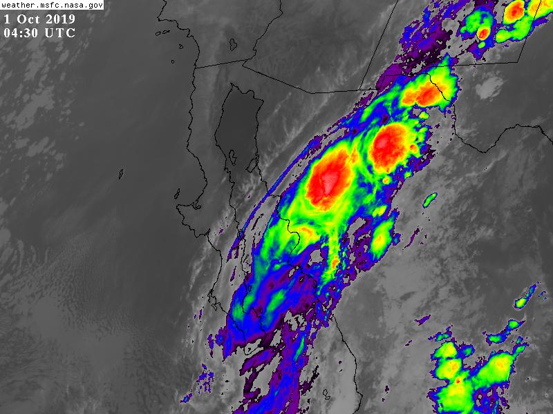
Passive microwave satellite imagery, especially a recent 2326 UTC
SSMI/S pass, continue to show that a small mid-level eye feature has
remained close to the northwestern coast of mainland Mexico since
the previous advisory, with the center now located just inland near
Los Mochis.  Earlier scatterometer surface wind data indicated
winds to near 40 kt about 40 n mi south of the center, and
extrapolation of the position of those winds would place them near
the coast now, and justifies lowering the current intensity to 40
kt.  Deep convection near the center has also decreased markedly
over the past few hours, further suggesting that the intensity has
likely decreased.

Narda has continued moving northwestward at an unusually fast
forward speed, or 325/17 kt. There is no significant change to the
previous track forecast or reasoning. The latest model guidance
remains in excellent agreement on Narda maintaining a northwestward
trajectory around the southwestern periphery of a large deep-layer
ridge for the next 48 hours, with the center remaining inland or
very near the coast during that time. The new NHC forecast track is
essentially on top of the previous advisory track, and lies close to
an average of the tightly packed consensus model tracks.

Now that Narda's center has moved inland again over the mountainous
terrain of coastal Mainland Mexico, steady weakening is expected
during the next 48 hours.  However, tropical-storm-force winds are
still possible, especially due to funneling along some of the
concave-shaped coastlines near Huatabampito and Guaymas before Narda
weakens to a depression in 24 hours or so.  Terrain interaction
should result in the small cyclone becoming a remnant low or
dissipating by 48 hours.

The main threat posed by Narda continues to be very heavy rainfall,
due to large amounts of moisture being advected northward and
northeastward over Mexico on the eastern side of the cyclone's
circulation.  These rains, which could total as much as 15 inches in
a few locations, will result in life-threatening flash floods and
mudslides.  Furthermore, the very humid mid- and upper-level remnant
moisture plume is expected to spread northeastward across northern
Mexico and into portions of the U.S. Southern and Central Plains
through at least Wednesday, enhancing the threat for heavy rainfall
and flash flooding in these areas.  For additional information,
please see excessive rainfall products issued by the NOAA Weather
Prediction Center at
https://www.wpc.ncep.noaa.gov/qpf/excess_rain.shtml.


FORECAST POSITIONS AND MAX WINDS

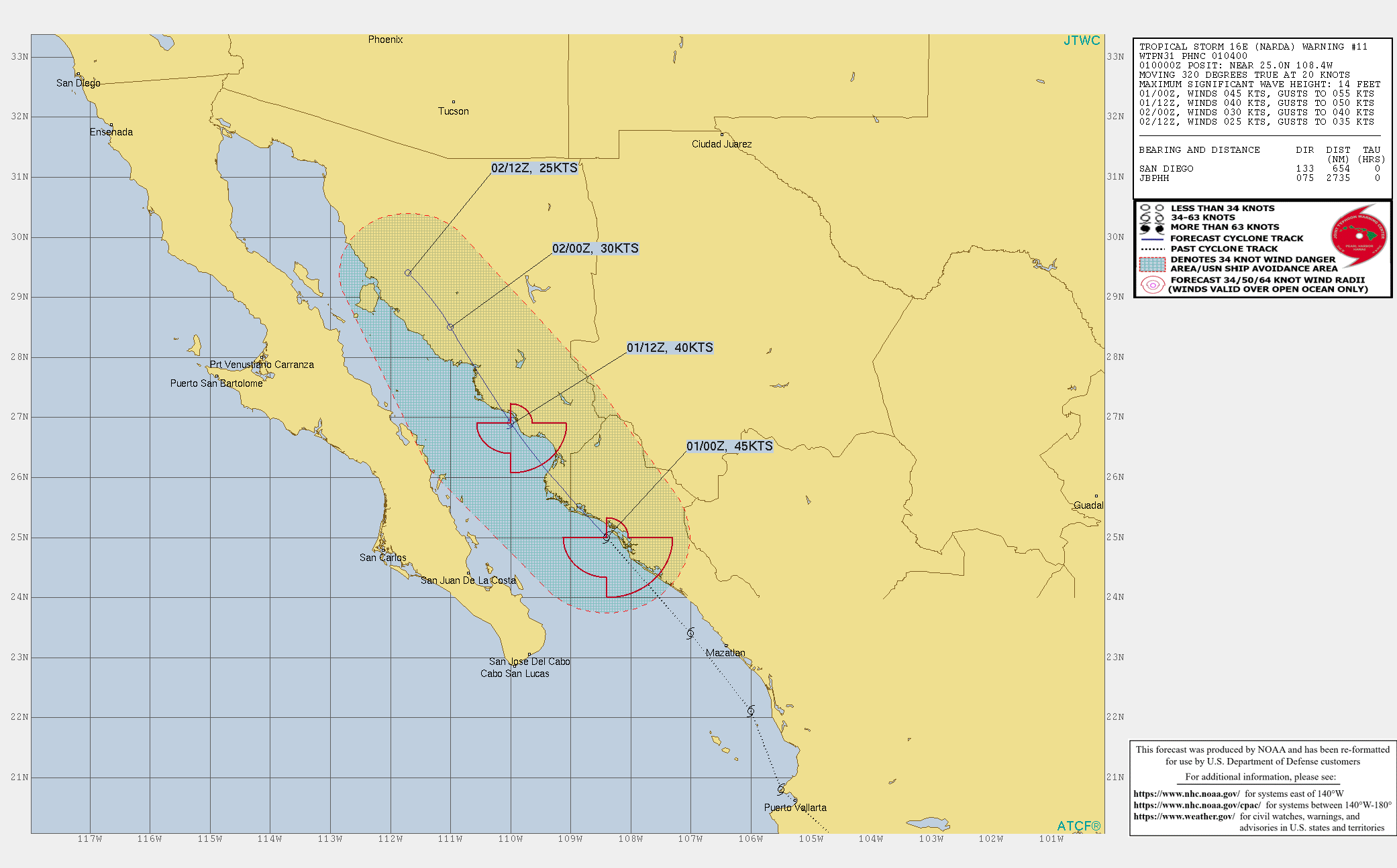
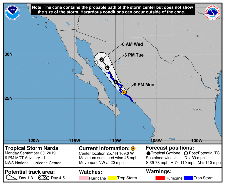
INIT  01/0300Z 25.7N 109.0W   40 KT  45 MPH...INLAND
12H  01/1200Z 26.9N 110.0W   35 KT  40 MPH...OVER WATER NEAR COAST
24H  02/0000Z 28.5N 111.0W   30 KT  35 MPH...INLAND
36H  02/1200Z 29.4N 111.7W   25 KT  30 MPH...INLAND
48H  03/0000Z...DISSIPATED INLAND

$$
Forecaster Stewart
025354_5day_cone_with_line.png

ep1619.gif

GOES04302019274GyMuUc.jpg

latestPAC.png
回復

使用道具 舉報

快速回覆
您需要登錄後才可以回帖 登錄 | 立即加入

本版積分規則

0908morakot

    主題

    帖子

    69萬

    積分

    12級[颶風Hurricane]

    Rank: 12Rank: 12Rank: 12

12級[颶風Hurricane]

發訊息

本平台僅供學術討論之用,預報應以氣象局為準

威普網站虛擬主機贊助公司

臺灣第一個天氣類型社群平台 即時天氣資訊、精準颱風動態

線上客服
FB傳送訊息
廣告行銷
精準行銷 物超所值
官方粉專
發佈 快速回復 返回頂部 返回列表